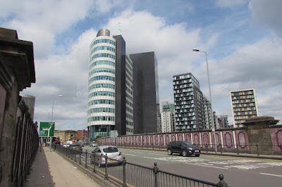
 |
| 2018 |
For those who don’t know Redbank nestles behind Cheetham Hill Road, rising up from the River Irk like a series of terraced olive groves starting at Scotland which faced the river.*
Not of course that there was anything exotic about the place. The area was well developed by the middle of the 19th century and rows of back to back properties existed beside a mix of industry.
 |
| 1936 |
I hazard a guess that the bright sunlight of early spring struggled to lift the spirits and banish the noise of assorted industrial processes which vied with the all pervading smell from the tannery.
 |
| 1930 |
The transformation began in the late 1930s when the houses were demolished and replaced by low rise industrial units which eventually also were demolished.
Now I am not old enough to have seen that transformation but there will be people who have.
After all, a person born in 1930 will be just 88 as I write this and could have played amongst the half demolished houses in 1936, worked in one of the small factories or warehouses thirty-years later and have been invited by a grandchild to view a flat in one of the tall apartment blocks that look down on Redbank today.
 |
| 1960 |
Location Redbank, 1850-2018
 |
| 1966 |
Pictures; the new developments, 2018 from the collection of Andy Robertson, and in 1936, m5139, later in the year, J F Stirling, m05142, and 1960, m05145 and 1966, T Brooks, m60605 courtesy of Manchester Libraries, Information and Archives, Manchester City Council, http://images.manchester.gov.uk/index.php?session=pass
*This stretch of Cheetham Hill Road was Ducie Bridge
Interesting article with fantastic photos.
ReplyDelete