Showing posts with label Alderfield Road. Show all posts

Tuesday, 20 January 2026

Waltham House ............. another of the lost houses of Edge Lane

Waltham House, 1959
This is Waltham House in the spring of 1959 and it was coming up for its 96th birthday but like many of those grand houses stretching along Edge Lane it had seen its best years.

It had been built in 1863 and was the home of Frederick Townley who a decade or so later had moved up the road to Stockton Range opposite the new church.

By then Waltham House was home to the Mr and Mrs Fowler, their three daughters, three servants and Mr Fowler’s brother.

Mr Fowler and his brother were “provision merchants” with a business on Corporation Street.

And in the fullness of time I will come back to the Fowler’s but for now it is their twelve roomed house which interests me.

Waltham House was one of the more impressive properties along that bit of Edge Lane which runs from  High Lane up to the junction with Wilbraham Road.

It was a big detached property standing in extensive grounds, set back from Edge Lane and approached along a curving drive.

And it would have been one of those properties you couldn’t have missed given that it had two entrances from the lane and before Wilbraham Road had been cut in the late 1860s would have commanded fine views north across open land up to Longford Brook and south to Turn Moss.

Not that the curious passerby would have seen much of the house as the front and rear were screened by rows of trees and  the northern boundary hidden by a line of green houses.

Waltham House 1893
That said it appears on the OS maps by name all of which I suspect would have gratified its owners who no doubt lived comfortable lives secluded behind those trees and that long stone wall which still runs along the lane.

Their neighbours might not have had their homes recorded on the OS map but were still proud enough of their properties to bestow fine sounding names on them.

West of Waltham House was Edgecombe Mount, Waterford, Hascombe, the Oaks and Thornlea, all built by the 1870s.

But these splendid names did not save them and most went during the 20th century.  Too big and too uneconomic to run their very size along with their grounds made them perfect for late 20th century redevelopment.

And now pretty much all that is left are the stone walls that fronted Edge Lane and the odd gate post with a lost name carved on it.

Waltham House, 1907
That said Thornlea has survived as the name of the flats that now occupy the site.

All of which brings me back to Waltham House which lasted longer than most and which during the last war was used by the Civil Defence, according to A E Landers who took the photograph of the house back in 1959.

It is an intriguing little story which needs following up but for now I am racking my brains to see if I can remember it.

In 1969 it appears not to have been occupied and may have been demolished when Belgravia Gardens was developed sometime in the 1990s, which means I should remember it.

Sadly I don’t and that more than anything reinforces that simple observation that you should never take anything for granted.

Pictures; Waltham House, nu 14 Edge Lane, A E Landers, 1959 m17783, courtesy of Manchester Libraries, Information and Archives, Manchester City Council, http://images.manchester.gov.uk/index.php?session=pass and detail of Edge Lane in 1893 from and the OS map of South Lancashire, 1893, courtesy of Digital Archives Association, http://www.digitalarchives.co.uk/ and Waltham House from  1907 OS map

Saturday, 3 January 2026

Mr and Mrs Heywood’s fine house ...... pushing back the history of Edge Lane

Looking towards Chorlton, with Heywood's house on our left, 1914
There will be someone I know who has the answer to the mystery of those two houses on Edge Lane which stood between Longford Park and Alderfield Road.

Mystery is perhaps over egging it a bit but they are there on the maps from the 1890s appear on the rate books for 1863 and will have been demolished well within living memory.

Now I can be pretty sure that they date from 1863 and the first residents will have been Mr & Mrs  Heywood who occupied the house beside the park and Mr John Bury who lived in the adjoining property.

The Heywood family can be tracked to Didsbury in 1851, Stretford a decade later and so I guess the move just across the boundary into Chorlton made sense.

Our two houses and a few more, 1893
Given that they were in Stretford in 1861 and the rate books show them on Edge Lane two years later I rather think they were the first occupants.

And it was an impressive house consisting of thirteen rooms, set in its own grounds and  with commanding views across open land to the north and south.

Mr Heywood variously described himself as a Land agent and Commission Agent who left his wife Hannah sufficient money for her to style herself as of “private means.”

And there is no doubt the family were well off.  In 1851 at the age of 38 he described himself as “retired” and on his death in 1874 left his wife Hannah £7000 and when she died in the November of 1911 she in turn left £12987.

Looking towards Stretford, 1914
All of which put them in good company for the other residents of the grand houses which stretched back towards the village were equally well off  describing themselves as professionals and merchants and living in properties which commanded rateable values of  up to nearly a £100 in the mid 1860s.

These represented what could be described as the first development boom, preceding the one that transformed the area around the Four Banks by almost 20 years.

In part I suspect it will have owed a lot to the arrival of the railway at the bottom of Edge Lane in 1849 which provided these people of plenty with a swift route into town and allowing them also to live in what was still a rural community.

One of the grand houses on Edge Lane and Alderfield Road ,1959
But a century later these grand homes were too big for modern living and they fell to the cheap jack developer who carved them up into bed sits or wiped them away altogether.

After all the the foot print of a house like ours along with its garden could accommodate a large block of flats with space left over for a car park

Happily those that survived have either been converted into more stylish flats or returned to single families.

Sadly ours were torn down.  I am not exactly sure when, but in 1969 the home of Mr and Mrs Heywood was occupied by a James Ashcroft while its neighbour had been subdivided.

So it will have been after that but when is as yet unclear.

On the other hand as so often happens someone  well pop up with the answer.

We shall see.

And within hours of posting the story Peter Thompson, commented that "the Alderfield Road flats were built in 1973. I worked on them as an apprentice painter and decorator aged 16, my first ever job."

And that I am guessing is just the start.

Additional research by Andy Robertson   

Next; some of the other fine homes of the people pf plenty on Edge Lane a century and ore ago

Pictures; looking north along Edge Lane with the Heywood house behind the wall to our left, 1914, Identifier m17758 , and looking towards Stretford, 1914, m17758, Edge lane north east junction with Alderfield Road, A E Lander, 1959, m17783, courtesy of Manchester Libraries, Information and Archives, Manchester City Council, http://images.manchester.gov.uk/index.php?session=pass and detail of Edge Lane in 1893 from and the OS map of South Lancashire, 1893, courtesy of Digital Archives Association, http://www.digitalarchives.co.uk/

Monday, 16 December 2024

That old bowling green and tennis club on Edge Lane and a mystery

The Club house, date unknown
Now here is one of those stories which intrigue me.

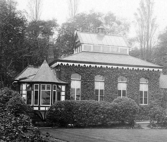
This is the Edge Lane Club House which confusingly was actually set back from Alderfield Road just by the boundary with Longford Park.

It was the home of the the Edge Lane Bowling and Tennis Club, which dated back to the 1860s.

Looking out from those big windows the 80 shareholders and 40 subscribers had a grand view of the Bowling Green and tennis courts.

Nor was that all for in 1886 our historian Thomas Ellwood commented that “the club grounds comprise something over two statute acres, and on this land there has been formed a bowling green, gymnasium, children’s playground, croquet and quoiting grounds, and four lawn tennis courts, besides a large and spacious billiard pavilion, and other apartments for club purposes.  

All are well kept, and interest in the various games is stimulated by a system of prizes.  In the past years opportunities have been afforded also for members, their families and friends, to participate in and enjoying garden and other parties, thus giving increased attraction and interest, and tending in no small degree to the welfare and success of the club.”*

It had begun as a modest club, “formed by a number of gentlemen who used to play bowls on the green then adjoining the Horse and Jockey.  For exclusive use of the green was reserved one afternoon in each week, in return for a small annual subscription, and the players generally partook of tea afterwards, and spent the evening together over a friendly game of cards." 

The club grounds in 1893
By the 1880s they were off Edge Lane and in 1924 they converted their grass courts into hard courts.**

This I suspect was in no small measure to the fact that they were according to the Manchester Guardian “one of the strongest in the Manchester district.”**

But something happened to the club and this I have yet to discover.

They are still there on that site a full decade later but by 1950 the club took the decision to wind themselves up.

In the June of that year they had held an Extraordinary General Meeting and decided “that in view of the sale by the Company of the whole Land, Premises and the Contents thereof situe at Kenwood Road, Stretford and as this prevents the Company from carrying on its business as a Club under the terms of its memorandum, it is herby resolved to wind up the Company voluntarily.....”***

Now here is the mystery for back in 1934, the club house, bowling green and courts by Alderfield Road are clearly marked on the OS map for that year, as are a bowling green, tennis courts, and pavilion and at the end of Kenwood Road.

So I am intrigued as to what happened to make the club move from its original site to Kenwood Road and then to decide to sell that site which effectively closed them down.

The story will be there but it will involve a bit of digging for I doubt that there will be many left who can recall the events of 64 years ago.

It maybe that the war and the immediate post war period were lean times.  That OS map shows more bowling greens and tennis courts in Longford Park which must have been a counter attraction.

So perhaps the club just ran into money difficulties relocated to Kenwood Road and sold that site too.

They had met at the old club house on Alderfield Road for their historic decision in 1950, but it maybe that by then the “the club grounds [comprising] something over two statute acres" had already been sold.

All of which leads to an attempt to date the properties that were built on the Kenwood Road grounds.

These could be from the late 1940s or a bit earlier or later and only a search of the street directories will establish a date and a hunt for the archives of the club.

So that is about it, from a club house to a mystery, all in a day’s blogging.

Location; Chorlton-cum=Hardy Manchester

* T. L. Ellwood, Bowling Greens, History of Chorlton-cum-Hardy, number 26, South Manchester Gazette, May 15, 1886

**Manchester Guardian, April 11, 1924

***The London Gazette, July 21 1950

Picture; the Edge Lane Club House, date unknown, courtesy of Bruce Anderson, and detail of the Edge Lane Bowling and Tennis Club, from the OS map of South Lancashire, 1893, courtesy of Digital Archives Association, http://www.digitalarchives.co.uk/

Saturday, 1 June 2024

Down Edge Lane at Alderfield and Rye Bank in 1845 ............ avoiding Mrs White and Mr Gresty

Edge Lane 1845
Now that stretch of Edge Lane which runs out of the old township up to Longford Park is somewhere I don’t often visit.

And that is a shame because it was one of those parts of Chorlton which had some fine houses built during the last quarter of the 19th century with stories which have yet to be discovered.

But today I am drawn to what I might have seen in the 1840s had I walked the road out from the village and up to Longford House which had been the home of Thomas Walker, one time pillar of Manchester society but also a radical politician who campaigned for the abolition of the slave trade, supported the French Revolution and was indicted for treason in 1794.

The family lived at Barlow Hall from the late 18th century spending the summer there before moving back for the winter to their town house on South Parade which faces what is now Parsonage Gardens.  And it was there that a mob attacked Walker who was forced to drive them off by discharging a pistol in the December of 1792.

Walker survived both the attacks and was acquitted of treason, after which he retired to the new family home at Longford House where he died in February 1817 and was buried in the parish church on the green.

Edge Lane in 1893
Now had I walked along Edge Lane in the summer of 1845 Longford House would not have been visible from the road and I would have to content myself with gazing at the row of trees that bordered the lane and which ran out on all sides surrounding the estate from the prying eyes of people like me.

I suppose I might have wandered across the fields which lay to the east of the estate.

These were Alder Field farmed by Mary White and Rye Bank farmed by James Gresty and on to Reap Bank.

But I would have had to be careful, the first two were arable fields probably growing barley and William Chessyre’s Reap Bank was Meadow land and no farmers now or then is happy at people wandering over their crops.

That said I wonder just when those fields were given over to development.  By 1893 there were two grand houses on the site of Alderfield and what is now Alderfield Road had been cut, pretty much ending where it does today.

It shouldn’t be too difficult to track the history of those two houses using the rate books, directories and census records and from that begin to plot the development of this small area which was home also to one of our oldest Bowling clubs.

And with that I rather think there will be more stories to add to those that have already been told on this little bit of Chorlton.

Pictures; detail of the area from the 1845 OS map for Lancashire, and the OS map of South Lancashire, 1893, courtesy of Digital Archives Association, http://www.digitalarchives.co.uk/

Next; creeping development along Edge Lane and a few interesting people.