Showing posts with label The Meadows. Show all posts

Monday, 27 July 2026

Hardy Farm ............ the picture I have never seen before

Now there are not that many pictures of Hardy Farm and that is a shame.

I included one of the most well known in the book on Chorlton but always cast around for more.*

During the writing of the book I became familiar with some of the farmers who lived there in the 19th century and collected stories from some who knew it from their child hood in the 1940’s and 50’s.

But the memories are fading and it will soon be a full half century since it was swept away for the ill fated UMIST sports scheme.

That said this picture brought back memories for  my friend Marion Jackson who remembers Hardy Farm.

“In my childhood the shed where the cows were milked was to the right. In front was a yard and further back to the right the orchard where the pigs were.


The track went down in front and then through the hawthorn hedges to Jacksons Boat.

I so loved my Sunday visits here with my father in the 40s. This was on his route to work in Sale from Withington by bike. Everything that my beloved father found interesting he showed to me.

This was a special favourite; I guess it reminded him of home in Cork. I used to look at the posh houses in South Drive as we cycled....guess where I lived for a happy 30 years? What a lovely life I have had.”

And that is all I have to say other than a thank you to Marion for sharing her recollections .

Picture; Hardy Farm, 1966, courtesy of Manchester Libraries, Information and Archives, Manchester City Council, http://images.manchester.gov.uk/index.php?session=pass

*The Story of Chorlton-cum-Hardy, Andrew Simpson, 2012, https://chorltonhistory.blogspot.co.uk/2011/11/the-story-of-chorlton-cum-hardy.html


Monday, 6 July 2026

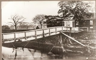
A history of Chorlton in just 20 objects number one ...... a bridge across the Mersey 1816

Now this will be a short series featuring objects which tell a story of Chorlton in just a paragraph and is also a challenge for people to suggest some that are personal to their stories.

They are in no particular order, and have been selected purely at random.

This was the first bridge across the Mersey on the edge of the township.  Samuel Wilton built it in 1816 at a cost of £200, but the ferry and the right to transport passengers across the Mersey were still in place in 1832 when the pub and the surrounding land were put up for sale.

At the time it was the landlord of the pub who benefited from the ferry charges.  The toll of a 1d to cross the bridge was abolished in the 1940s.

Picture; from the Lloyd collection 1865

Saturday, 27 June 2026

A day out on the meadows ..... circa 1910


The caption reads, “the footbridge over the stream at Brook Road entrance to the meadows. 

 From this bridge there was a diagonal path across Boat Meadow to Jackson’s footbridge which was part of the normal path from the green to the pub by the Mersey.” 

It is dated 1910.

The picture is a perfect reminder that the area was farmed as meadow land which involved regularly flooding the land from a series of irrigation ditches.

Picture; from the Lloyd collection

Saturday, 20 June 2026

A lost bridge across the Brook


Now I think it is time for a walk across the meadows in search of Mosley Bridge.

It was a small bridge over the Brook put up by Charles Walker and later washed away.  Charles Walker was the son of Thomas Walker, the radical, and lived at Longford Hall and the bridge connected his land on either side of the brook.

In the 1830s it was destroyed by a flood, and a new one was built where the brook joins the Mersey which makes it easy to find.  It’s there on the old tithe map of 1845 and looks to be roughly where the bridge is today.

But I am not sure that this is our bridge.  Over the last fifty years the banks and the land on either side of where the brook runs into the Mersey have been raised a number of times but from memory the masonry looks old.  And a bridge does show up on the right spot not only the tithe map of 1845 but on the earlier OS for 1841 and the later OS of 1888-93.

So far I have not come across any old photographs of the bridge but there is a painting made by J Montgomery in 1963 looking east along the line of the Brook.  Stand on that exact spot today and to the south there is a dense collection of bushes and small trees which were entirely missing when Montgomery recorded the scene.

But neither his or the modern view are how it was.  Back in the 1840s, to the south of the Brook on what was Charles Walker’s land were water meadows, while away to our left just beyond the field was Walker’s orchard.

Now before I take a walk down to the spot I should really ask my old botanist pal David Bishop whose knowledge of the place goes back to the 1970s and whose blog at http://friendsofchorltonmeadows.blogspot.co.uk/ is a wonderful collection of information about the land and the plant life along this stretch of the Mersey on the edge of our township.

Picture; Courtesy of Manchester Libraries, Information and Archives, Manchester City Council, Junction of Gore Brook [Chorlton Brook] and the River Mersey, J Montgomery 1963, m80140

Friday, 22 May 2026

Watching the Meadows change ......... June 1965

I wonder just how many people remember this scene?

We are on the Meadows, and according to the caption this was “June 16, 1965, Clearing Water Street Cleansing Department, View of Hardy Depot”.

It is one of the photographs generated by Neil Simpson who “ worked on the Town Hall Photographer's Collection Digitisation Project, in the Central Library, which currently is Volunteer led and Volunteer staffed.

The negatives in the collection are dated from 1956 to 2007 and there are approximately 200,000 negatives to be digitised at three minutes a scan.


This is an image I have never seen before and I am guessing the building must be Hardy Farm.

That said I am puzzled by the bit of the caption referring to Water Street and am not too arrogant to admit to being stumped by it.

I have never come across the name during all my years in Chorlton, or in the research I have done.

So this is one to turn over to anyone who remembers the scene, walked that bit of Hardy Lane or can offer an explanation to the name.

Of course there might be a clue in the buildings in the distance which don't suggest we are looking at where Hardy Lane runs out on to the Meadows.

I wonder whether were instead on Turn Moss with Stretford in the distance.

And that just leaves me to open up the debate, which no sooner had I posted the story and Bill Sumner replied, with,

"I think the view above is taken from the bottom of Bradley Lane next to the water treatment/sewage works. the line of electric pylons is correct and is still there today, but the gas holder is not the one at Gorse Hill Stretford but the one at Dane Road Sale. 


Looking on Old Maps I cannot find a Water St either. The Dane Roadd Gas Holder was built in 1935 on the old sewage works site and was built as an extension to Stretford Gas Co that also supplied Sale and Ashton on Mersey. 

The gas holder in Stretford would have been out of sight to the left of photo. The old cottage would have disappeared because the Stretford Works was enlarged and a row of staff houses built here in the 1960's, probably the reason this photo was taken. Thanks for the new view"

And quick as a flash Neil also responded with "I can answer some of your questions Andrew. 

This image was in a set taken for Manchester Corporation's Cleansing Department, who were based at a huge site on Water Street near MOSI in Manchester. 

They had a Destructor on that site (is an incinerator) and roughly sorted the refuse collected into 'for burning' or 'tipping'.

Some of the refuse for tipping was taken to Hardy Lane Farm as they were using it to 'reclaim' land.

Bill Sumner was quite right in saying that the Gasholder was the one at Dane Road as I worked that out earlier."

And the final word goes to Ann who spotted the obvious, "have just read your comment, think the quotation should read ' Cleaning water, Street Cleansing Dept' Comma missing. Explains why there isn't a Water Street in Chorlton."

Not much more to say than thank you,  Bill, Neil.and Ann

Location; the Meadows

Picture; June 16, 1965, Clearing Water Street Cleansing Department, View of Hardy Depot, courtesy of Manchester Libraries, Information and Archives, Manchester City Council, http://images.manchester.gov.uk/index.php?session=pass


Tuesday, 28 April 2026

Living on our Meadows ...... stories from the Brownhill family

We are on the meadows, when people still worked and lived there.

Now everyone knows about the sewage works which were first established here in the 1870s, continued well into the last century.

Less well known perhaps is that two families of those who worked on the plant lived close by, and their houses stood by what is now the footbridge over the Brook.

The rest as they say belongs to Catherine Brownhill who sent over these pictures and the accompanying story.

“Hi Andrew, Malcolm (my husband) lived at No. 1 Cottage, Withington Sewage Works. Hughie  and Lily Edwards lived next door. Lily was 90 last October and Malcolm & his brother went to visit her. 

He has taken some pictures of photographs from her album. 

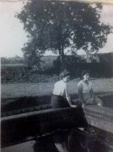
Over the next few days I’ll send them to you with as much info as I can. This picture is likely Lily and a friend at the Sewage Works. Ivygreen Road houses are in the background. The 2 cottages would be to the right of this picture. The tree is still there today.

This is the same tree with the ‘cottages’ in the picture. They were sturdy brick built semi-detached houses. 

Malcolm’s Dad, Jack Brownhill can be seen bowling in a game of cricket. 

The cottages were at the end of the cobbled road just where the bridge is. 

Below are the four Brownhill children. Jack and Irene were their parents. 

Over the years Irene worked in the laundry on Crossland Road and in three chip shops, on the Green and Beech Road. She attended the school on the Green. 

Pictured are Jeanette, Malcolm, Graham and Ray with the air gun.

The last one for today. 

These buildings were in front of the cottages and to the left and the buildings behind housed the engine room and various sheds. 


Back to the photo, where the car/van is this was a barn where straw was stored for the sheep in the fields and chickens were kept in one of the rooms to the right. Malc’s Dad had a Morris Minor and all the lads would take turns to drive it, Malc could only just see above the steering wheel. 

It was chopped up at the end of its life and was put over the bank of the brook. 

Bits of it may still be there, though we think that when the banks were reinforced in recent years the motor debris may have been cleared. This would have been to the left of where the bridge is now”.

Location; the Meadows

Pictures; living on the Meadows, circa 1950s-60s, from the Brownhill Collection

Saturday, 11 April 2026

What a difference 68 years makes …….. deep in Chorlton

Now here is an image of Chorlton which will nudge some memories.

We are on that twisty path which leads off from Brookburn Road, following the line of the Brook.

I have walked it countless times over the years, but only always remember it as a tree lined route into the heart of the meadows.

As such on a wet February day with the light fading fast it can be a magical place, which is no less so in high summer when the dense vegetation makes it a place where you can feel quite alone.

Originally the road had been constructed to give access to the sewage plant which was built and enlarged from the 1870s.


Before that the area which we now call the Meadows, and which was part of the flood plain for the Mersey had been farmed as meadowland, which is a type of farming dating back to the 17th century and involves careful flooding of the land at intervals, for the production of early grass to feed the cattle.

In the 1930s, bits were used for tipping rubbish and more recently it has become part of the Mersey Valley, whose wardens dramatically altered the landscape with whole planting of trees.

So, this picture is a revelation of how it once looked.  The caption says, “Chorlton-cum-Hardy, Brookburn Road, Withington Sewage Works, Boy Scouts Hut, Entrance to Manchester Corporation (Rivers' Dept), Withington Sewage Works from Brookburn Road, Boy Scouts Hut in middle distance”.

Leaving me just to say, ......... step forward those who remember it as such.

Location; Chorlton

Picture; Entrance to Manchester Corporation (Rivers' Dept), Withington Sewage Works from Brookburn Road, Boy Scouts Hut in middle distance, 1958, R.E. Stanley,  courtesy of Manchester Libraries, Information and Archives, Manchester City Council, http://images.manchester.gov.uk/index.php?session=pass

Friday, 6 February 2026

A painting of the meadows, a mystery ……….. and stories yet to be told

This is Hawthorn Lane, which is part of the Old Road, which snaked through Chorlton from Hardy Lane, skirting the parish church before heading off east across the Meadows to Stretford.

We can’t be sure when it was painted, or whether it was an attempt to recreate a much earlier scene.

But what I do know, is that it is the work of Thomas Crowhurst, who was living at no. 15 St Clements Road from 1872 till 1892.

He describes himself variously as a “Teacher of Drawing” and “Artist, teacher and landscape painter”, and he was born in Cornwall in 1835.

His wife Ellen was also a teacher and they employed a Governess who was also a “Teacher of French and German”.

I can track them from 1866 when he was living in Cheetham Hill, but lose them after 1891, although there are hints to where they lived subsequently.

The painting was acquired by a friend about 4 years ago, and is important because it is only one of two dating from the 19th century which I have come come across.

There in the distance is St Clements Church, and I suspect there will be plenty of people who spend a bit of time trying to locate exactly where Mr. Crowhurst stood when he painted the scene.

Walking the lane today, there is one possible bend which might be the one shown, but of course the view across to the church has changed beyond recognition.

In the 19th century this was still meadow land, farmed specifically for the purpose of growing “spring grass”, but during the last century the area was subject to Corporation waste tipping, followed by dramatic landscaping by the wardens of the Mersey Valley which created pretty much what we see today.

So that makes Thomas Crowhurst’s painting so important.

But never one to shy away from a bit of family prying I went looking for the man and his family and there is a story ……….. indeed quite a few.

Back in 1871 he was living with his wife Ellen in Walnut Street, in Cheetham Hill, and gave his occupation as a “Clerk in a Wholesale Drapery House” and Ellen appears not to be employed.
Walnut Street is still there and consists of modest terraced houses, which are a contrast to the property they moved to when they settled in Chorlton.

Just where they worked as teachers is yet to be discovered, but they had a full house in St Clements Road.  Along with the two of them, there was a son, two boarders, two servants and Ms Bertha Rath the Governess.

What is equally intriguing is that one of the two boarders, was their niece, and a decade later she is listed as “adopted daughter”.

She was Dora Helen Cornish and a search of the census records reveals someone of that name, of the right age, and birthplace living with her mother in the south.

All of which betokens more stories.

And in the meantime, perhaps a walk down Hawthorn Lane, armed with his paintings and the task of comparing the scene today with that of when Mr. Crowhurst put paint to canvas.

Location; Hawthorn Lane

Picture; Hawthorn Lane, Thomas Crowhurst, date unknown

Sunday, 21 December 2025

The Lost Chorlton pictures ......... no 7. ......... snow across the meadows

The meadows are a special place for me.

During the time the lads were growing up it was a place we went to a lot, often with the dog and always looking for adventures.

More recently it became a subject for research, because long before it became a nature reserve, a place to tip household rubbish or even before the sewage works, it was farmed as meadowland.

This was a particular form of farming which involved the flooding draining and flooding again of the open land in a specific way and designed to grow “early grass” for feeding to the cattle.

Sometime in the winter of 1978 or '79 I wandered across the stretch from Brookburn Road to the Mersey.

It was a bitterly cold day, more cold than we get these days and the snow stubbornly refused to melt.

I suppose if I checked back using the weather records I could pinpoint the exact year but I won’t.

Location; Chorlton


Picture; the meadows,1978-79 from the collection of Andrew Simpson

Sunday, 14 December 2025

Two parks .....a recreation ground ..... the stolen village green ..... and the Mersey Valley ... now that's our new book

 The story of Chorlton’s open spaces has yet to be told, and with that story will come heaps of memories.

Alexandra Park, 1937

And prompted by those two thoughts, Peter and I have embarked on the our next book which will explore the stories of all our open spaces from the Rec on Beech Road, to Chorlton Park, Alexandra Park and that large open piece of land out by the Mersey.

Chorlton Park, circa 1930s

Along the way we will take in Chorlton Green which was stolen by Sam Wilton sometime in the early 19th century, and only returned to the village after the death of his last daughter in the 1890s..

Added to this we will include a chapter on the bowling greens as well as the fields and market gardens when Chorlton was still a rural community.

We are particulary pleased that my old friend David Bishop has agreed to write the chapter on the Meadows.  

The Meadows, 2019

David is a well known botanist who regularly is asked to speak on a range of topics related to his work and recently addressed an American University.  

He was in at the beginning of the project to turn the neglected area of land by the river into the Mersey Valley, and in fact started exploring the area soon after the sewage works had closed down in the 1970s.

There will be those who question the inclusion of Alexandra Park, but both our families have used the facility over the years, and I bet lots of Chorlton people also have fond memories, so it’s in the book.

Nor will we stop there because we could also include people's gardens, providing of course they would be happy to show them off, once a year when Chorlton proud gardeners open their gardens to the public.

The Meadows, 1979
And that just brings me to the request because there will be lots of people with their own stories, and pictures which we would like to include., and of course those gardens. 

These can be sent as a comment to the blog, or to the Facebook sites, Chorlton History, and Glad to be in Chorlton, or by phone to me on 0161 861 0105.

So to start you all off.  There was a barrage balloon of the Recreational Ground, Chorlton Green once had a drinking fountain, The Meadows regularly hosted winter skating and Chorlton Park was built with a civic theatre.

The lost drinking fountain, Chorlton Green, circa 1900

Location; Chorlton and a few bits beyond

Picture; Sunday in Alexandra Park, 1937, from Manchester, heart of the Industrial North, Manchester Chamber of Commerce, 1937, Chorlton Park circa 1930s, and the lost water fountain on Chorlton Green, circa 1900, the Lloyd Collection, and the Meadows in 2019, and 1979, from the collection of Andrew Simpson


Tuesday, 25 November 2025

The day I thought I was in the country …… urban tales from Chorlton-cum-Hardy

Now, the purist will immediately point out I was not in Chorlton nor the countryside.


But on a hot summer’s day sometime at the end of the 1970s I rather thought I was.

I had taken myself off across the meadows and discovered the old weir at that bend in the Mersey.

The weir had been built in the 18th century to break the force of a flood surge which might have damaged the aqueduct carrying the Duke’s Canal.

The river regularly flooded in earlier centuries and once in the 1840s the force of that surge was so strong it damaged the weir itself.

Even now the base of the weir can still be marshy and after a wet winter the water will stretch out into the surrounding land.

On the day I discovered the spot there was just a hint of water but enough for the cows who grazed on the grass.

And it was the cows, the pasture and the steeple that offered up the illusion of somewhere rural.

Although I did have to frame the picture to miss the tower block and get the chapel of Stretford Cemetery in the centre.*

And before any one sneers, .... yes the quality of the pictures was poor.  In my defence I was just beginning to develop and print images using smelly photography and the negatives have sat in our cellar for over 40 years.

Location; the meadows west of the Mersey, circa 1978, from the collection of Andrew Simpson

*Stretford Cemetery, https://www.trafford.gov.uk/residents/births-deaths-and-marriages/burials-and-cremations/cemeteries-and-crematoria-in-Trafford/stretford-cemetery.aspx


Saturday, 22 November 2025

The mystery at Ivygreen ..........

Now I know I am on Ivygreen Road and the date will be around 1980 but exactly where almost defeats me.

So, hence the mystery.

My very first inclination was that I took the pictures at the top end, but that wouldn’t have given me that clear view across to the pumping station.

All of which means that we are at the Bowling Green end, and this is the site of Allan Court.

And that offers up a surprise because it means that the blocks of flats post date my arrival, although I have no recollection of them being built.

But the entrance in the photograph corresponds to what is now the drive into the car park so I am fairly certain where I was on that winter day in 1980.

Added to which other pictures in the batch include views of the rear of the parish churchyard and a shot up St Clements Road to the village green.

So it follows that I was at the bottom of Ivygreen.

At which point there may be those that mutter about a non story, but not so, because both images give a very clear idea of what the meadows once looked like, before the trees and bushes were planted and before they matured to make it impossible to see far away across to the river.

All that we now need, is for someone to describe what had been here on this bit of land beside the road.

I rather think it was a builder’s yard which may have belonged to Joe Scott, and at one time also used by the Walker Brothers who later moved into the barn at Higginbotham’s Farm.

Well we shall see

Location; Chorlton

Picture; Ivygreen Road, 1980, from the collection of Andrew Simpson

Thursday, 9 October 2025

That rural scene in the heart of Chorlton …….

Of course, the title would not pass the test of accuracy, given that we are actually just over the border into Stretford and the description rural is stretching it a bit.

But you would be forgiven into thinking that with the fields, cows and church spire we could be in the sort of landscape loved by Constable.

And in as much as it will never be built on and there were cows it could be sort of rural, and that was just what I thought when I came across the scene in 1979.

I was standing on the top of the weir built to protect the Duke’s Canal from a flood surge and rebuilt in the 1840s after it’s failed to stem the storm waters. 

Then and now I still enjoy the view, and while the pool in front of the weir can shrink it never quite goes away and after a wet period will fill up.


As for the church spire it is not some medieval church but was built when Stretford cemetery was opened in 1885.

All of that said I like the spot.

And it does have echo of the past, because if you ignore the cemetery to the right and the spire, the view would not look so different to someone standing on the same spot in the 1850s.

Back then.much of this land was meadowland.


Location; looking out from the weir in the bend of the river

Pictures; a lost rural scene, 1979 from the collection of Andrew Simpson


Monday, 29 September 2025

Sad stories of the deaths at Sally's Pond..... out on Turn Moss …….

This is the newspaper report on the death of Samuel Wood, for which Chris Geliher sent over to me about an hour ago.

Manchester Evening News, 1887

Chris added that “I came across this and thought it might be of interest to you Andrew if you haven't already seen it. It comes from the Manchester Evening News and is dated July 14th 1887”. 

Now I hadn’t and the story drew me.

Sally's Hole, Sally's Pond, 1958
Sally’s Hole was a pond on Turn Moss, whose name is lost centuries ago but the popular understanding was that a young woman named Sally downed in the water and that the death was suicide.

It is a place I often write about.”*

Today despite being filled in sometime in the 1960s the location can still be found just off the old carter’s track that leads out across the meadows to Stretford.

It surrounded by trees and overgrown vegetation and get there just as the light is fading and it sems a foreboding place which even in summer is dank and dark, and standing there offers up an unsettling feeling where anything is possible.

Alas the trees and vegetation are relatively new and instead through the 19th century and beyond the pond was in an open space with views in all directions, but even so it had a reputation as a place not to linger.

Travis Street, 1916
But linger I did  and began looking for the three named individuals who played a part in the story.  Woods, turned out to be Samuel Woods who was living on Travis Street in 1884 and paying a weekly rent of six shillings which was a cut above most of the rents paid.  

The street is still there running from Fairfield Street to London Road, but all the houses have gone, and today it is bordered at one end by part of the Mayfield Railway station and with the rest being grass verges hiding a series of nondescript car parks.

And so far that is about it for Mr. Wood, sadly the genealogical platforms show that he shares no one who has claimed his as a relative.

And another account, 1887
As for Henry Mellor he was 21 when he came across the body and described himself as a “gardener domestic” living with his parents on Chorlton Green.

PC Hobden has yet to come out of the shadows, but his records may be in the archives of the Greater Manchester Police Museum, and there is more on Henrry Mellor.

And I bet the two of them will have talked about the incident and in doing so rekindled the scary mystery of Sally’s Hole.

Leaving me just to thank Chris, who turned up another press cutting which allows a little more detail and the chance of more researc,

Picture; Sally’s Field, J Montgomery, 1958, copied from a 1945 photograph, m80104, Travis Street, 1916, m10665, courtesy of Manchester Libraries, Information and Archives, Manchester City Council, http://images.manchester.gov.uk/index.php?session=pass

*Sally's Hole,  https://chorltonhistory.blogspot.com/search?q=sally%27s+hole


Sunday, 31 August 2025

Snaps of Chorlton No 10, farming some where in Chorlton


An occasional series featuring private and personal photographs of Chorlton.

This is one of my favourite pictures in the collection and it is special for a number of reasons.

First it was lent to me by my friend Allan Brown who had lived here around the village green for his entire life and the seated couple are his grandmother and great grandfather which take his link with the township back into the 19th century.

But it is also because it is one of the few photographs of Chorlton which show people still working the land.

I don’t have a date or a location but we may be in the last quarter of the 19th century somewhere in Chorlton but it featured in my book The Story of Chorlton-cum-Hardy.*


Picture; from the collection of Allan Brown

*http://chorltonhistory.blogspot.co.uk/search/label/A%20new%20book%20for%20Chorlton

Wednesday, 20 August 2025

Defending Chorlton and Didsbury from the fury of the Mersey

Now there is a caption competition here but I leave that to the swift of mind who can call up a witty aside on the turn of a sixpence.

All I will say is that we are back in 1966 at that point on the Mersey where the new bridge crosses the river by the pub.

And not for the first time over the last few centuries work is underway on the river banks,

These have been raised and raised to protect us from the river which in the past could flood with little warning and cover the meadows in a lake which stretched for miles.

The last time this happened on our side of the Mersey was in 1912 and there are pictures of the flood water poring over the weir which had been built to protect the Duke’s Canal.

There are plenty of stories of those flash floods which during the 19th century were common enough to enter local folk lore and have been reproduced in the book on Chorlton-cum-Hardy.*

And that is about all I am going to say other than that the story of Jackson’s Boat and its many different names is covered in that book and in the latest on Chorlton’s pubs and bars.**

But I shall just finish with one last comment on the image which and has recently come to light through a new project.

Neil Simpson tells me that "the Town Hall Photographer's Collection Digitisation Project, which is Volunteer led and Volunteer staffed, is in the process of systematically scanning the 200,000+ negatives in the collection dating from 1956 to 2007.

The plan is to gradually make the scanned images available online - initially on Manchester Archives+ Flickr and later on other Archives+ digital platforms.***"

*Manchester City Council Archives+ Town Hall Photographer's Collection Flickr Album...

And that is all I have to say other than a thank you to Neil and the team.

Location; Chorlton

Picture; Down by the Mersey, 1966, courtesy of Manchester Libraries, Information and Archives, Manchester City Council, http://images.manchester.gov.uk/index.php?session=pass

*The Story of Chorlton-cum-Hardy, Andrew Simpson, 2012, https://chorltonhistory.blogspot.co.uk/2014/12/the-story-of-chorlton-cum-hardy.html 

**A new book on the pubs and bars of Chorlton, https://chorltonhistory.blogspot.co.uk/2017/05/chorlton-pubs-and-bars-book-has-arrived.html

***Manchester City Council Archives+ Town Hall Photographer's Collection Flickr Album...

Tuesday, 19 August 2025

The benign and fairly gentle River Mersey


The Mersey up by the meadows and down past Jackson’s Boat can seem a benign and fairly gentle stretch of water.

And this picture taken some time in the early 20th century captures just such a moment.

It was taken on the edge of the township by Red Bank Farm which was lonely outposts hard by the river, well away from the rest of community.

Another peaceful scene, May 2009
It is a peaceful scene on a warm sunny day and you can see why our commercial photographer went to the trouble to take the scene.

As it turns out he took more than one and there are a whole series shot on the same day along this part of the water.

He must have had it easier then to get the water’s edge.

Most of the river at this point is today viewed from towering banks built and added to over the centuries as the main defence against a powerful threat to the lives and livelihoods of all those who lived beside it.

And a less peaceful scene, February, 1991
Generations of farmers have laboured to construct this natural wall to repel the flood waters of the Mersey and three are plenty of moments when our benign and fairly gentle stretch of water burst even these defences, in what were sometimes flash floods and often such an immense tide of water that it created a huge lake several miles wide across the meadows.

Here below in the February of 1991 the Mersey was just lapping the top of the uppermost bank.


Location; along the Mersey

Pictures; from the Lloyd collection, circa 1900, and the collections of David Bishop, 1991 and Andrew Simpson, 2009

Friday, 25 July 2025

A photograph, a lost stream and a bit of a detective story


It’s often the way it works.

You start off with a picture and in beginning to uncover its secrets discover a whole lot more.

So there I was with this 1950 photograph from the Lloyd collection.  The caption just said “The ‘Marsh Meadow’ [Marshe Brow] from the ‘The Tip’. 1950."

It is in itself a pretty historic picture marking as it does one of the last times this stretch of land will have been worked on a regular basis.  As such it will be part of a continuity that stretches way back into our rural the past.

So as you do I set out to locate the exact spot which was easy enough to do.  It is at the point on the modern meadows where Ivy Green Road suddenly twists north to join Cartwright Road and Hawthorn Lane.

Now I never quite understood the logic of this as the rest of Ivy Green carries on only to peter out as a dead end.  But look at the old Tithe map and the OS map and the original lane turns north and then east which today is Hawthorn Lane.

And our picture was taken I think just inside the entrance to the Meadows by the gate from Ivy Green.  This was Lloyd land and back in the 1840s was farmed by John Cookson of Dark Lane whose 59 acres were mostly on land along Buckingham Road where it joins Manchester Road.  It was a mix of mainly arable with some pasture and meadow land.  But like many of our farmers he also had land away from the farm on the meadows and this was Marsh Brow which was five acres of meadow.

But in trawling across the field names I also came across Row Leech and what I have looked at on all the maps but not seen.  For here is confirmation that the Rough Leech Gutter which ran from just north of Sandy Lane across the township and under Edge Lane by the parish church finished in a big pond on Turn Moss.

“Meadow land was not only a common enough feature here in the township but important to the way we farmed.    Meadowland is grassland that is kept damp by the use of ditches called carriers worked by sluice gates fed from the Mersey.


The skill is to keep the land fed with water up to an inch in depth through from October to January, for about fifteen to twenty days at a time before allowing the water to run off into the drainage ditches.  The land must then be left to dry out for 5-6 days so that the air can get to the grass.  The early watering took advantage of the autumnal floods which brought with them a mix of nutrients and silt which enriched the land.

All this requires constant vigilance and Higginbotham the farmer on the Green would expect to visit his fields once every three or four days to see that the water was evenly distributed, and that there was no accumulation of weeds. This was not a task that could be entrusted to an unskilled manager, as the weather and time of year dictated the level of water that needed to flow from the irrigation ditches.  And as the weather got colder it would be important to watch for a hard frost which if it were severe enough could turn the meadow into ‘one sheet of ice which will draw the grass into heaps which is very injurious to meadows.’

Not that this stopped Alfred Higginbotham annually flooding one of his fields in the early 20th century to provide a skating ring for the village.

The rewards for all this care and hard work were many.  During the winter the water protected the grass roots from frost allowing the grass to grow several weeks earlier while in hot summers it kept the grass lush and provided grazing for the cattle as well as hay.*

And just as I was finishing the story I came across an interesting post on Making a Meadow on Ivy Green from the site Friends of Chorlton Meadows,

http://friendsofchorltonmeadows.blogspot.co.uk/2012/10/making-meadow-on-ivy-green.html

Pictures; from the Lloyd collection and detail of Marsh Brow and Row Leech from the OS map of Lancashire 1841, courtsey of Digital Archives, http://www.digitalarchives.co.uk/  

*The Story of Chorlton-cum-Hardy, Andrew Simpson, 2012

Thursday, 3 July 2025

Of floods and weirs and floating hay ricks


"It was," wrote Thomas Ellwood the local historian
“no uncommon thing to see the great level of green fields completely covered with water presenting the appearance of a large lake , several miles in circuit.”

It was for this reason that the weir was built.  Just beyond the point where the Brook joins the Mersey and at a bend in the river the weir was built to divert flood water from the Mersey down channels harmlessly out to Stretford and the Kicketty Brook.

After a heavy flood in August 1799 broke the banks where Chorlton Brook joined the Mersey, there were fears that the Bridgewater Aqueduct across the flood plain could be damaged by flooding it was decided to build an overflow channel improving the course of Kicketty Brook and build the stone weir.

Not that it always worked.  Soon after it had been built flood water swept it away and during the nineteenth century neither the weir nor the heighted river banks prevented the Mersey bursting out across the plain.

In July 1828 the Mersey flood water transported hay ricks from the farm behind Barlow Hall down to Stretford only later to bring them back, while on another occasion one man was forced to take refuge in a birch tree till the following morning.

Later floods proved to be even more destructive, destroying a bridge across Chorlton Brook and making for six major floods between  December 1880 and October  1881. The last time the weir took an overflow of flood water was 1915.

On a cold bleak and rain swept morning it is possible to sense the importance of the weir.

Stretching out from the wall is a deep and placid pool of water home to ducks and broken by bunches of water plants.

But with just a little imagination how different it might have been on a stormy night when the river swollen with rain water burst over the weir.

Pictures; Higginbotham’s field in flood, J Montgomery 1963, painted from a photograph dated 1946, m800092, Courtesy of Manchester Libraries, Information and Archives, Manchester City Council, picture of weir in 1915 from the collection of Tony Walker

Tuesday, 10 June 2025

That “bright little suburb” ………… Chorlton-cum-Hardy and its pub across the water

Now I can see that attraction of these two picture postcards which were marketed by the Rapid Art Photography Company sometime in the 1930s.

In the previous fifty years, great swathes of Chorlton had been built over, and what had once been fields, farms and market gardens had become rows of terraced and semidetached houses for the middling people who worked in the city and wanted the vestiges of a rural setting when they came home.

And that stretch of land from the old Chorlton village to the Mersey offered just that degree of open countryside, with the added benefit of a pub on the banks of the river.

None of this was lost on the Manchester Guardian which reported on May 10th, 1914, that “Jackson’s Boat is the picturesque connecting link between Chorlton and Sale.  There is no boat there now, whatever there may have been at one time, but there is a half penny toll bridge for foot passengers and a pleasant inn.  You need not pay the half penny if you prefer to take a glass at the inn”.

Concluding that “Chorlton itself is a particularly bright little suburb.  

It somehow has the clean, cheery, holiday aspect of a seaside resort.  

Chorlton has been described as the favourite suburb of newly married couples, and perhaps what one notices is a honeymoon atmosphere”.*

And where better for a romantic stroll than across the Meadows to the pub across the water.

The footbridge dates from the 1880s and replaced an earlier one constructed by Samuel Wilton in 1818, although landlords of the pub continued to retain the right to ferry people across the river by boat and charge a fee well into the 1830s.**

In its time the pub was known variously as the Old Greyhound, the Greyhound and the Boathouse, and dates from the 1780s.

And for the eager tourist wanting to travel out from the city centre, “the tram fare to Chorlton is 1d to Seymour Grove, or 1½d. right through to the village, [while] a third class  railway contract costs 18s a quarter, which works out at about 1s 5d. a week”.

To which I can only add that on the side of the trams and over printed on the railway tickets should have been the simple entreaty “Go South you young couples”.

Location; Chorlton

Pictures; Jackson’s Boat, circa 1930s, courtesy of Jennie Brooks

*Where to Live and when to Buy, The Manchester Guardian, May 10th, 1914

**Jackson’s Boat, https://chorltonhistory.blogspot.com/search/label/Jackson%27s%20Boat