Showing posts with label Chorlton Row. Show all posts

Monday, 30 June 2025

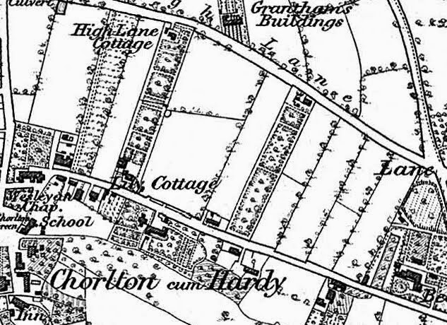
Chorlton Row, a road half as old as time


You have to get up early to see Beech Road at its best, preferably on a spring or summer morning when there is no traffic on the road.

 Only then can you can get a real sense of how it twists and turns following long forgotten obstacles like the old beech tree which stood for most of the 19th century almost opposite Reeves Road and the field boundaries which cut into the road.

For me the best vantage point is at the corner of Wilton Road by the railings of the Rec. Look up towards Barlow Moor Road and its twists and turns more than once, while its lazy route down to the green is even more pronounced.

I guess it will be almost as old as time, linking Barlow Moor Road with the village green and in probability was there before the Tudor buildings which include the Horse & Jockey. Various dates have been suggested for the block but its position beside the road as it turns onto the green would suggest that it post dates the road.

Picture; detail from the 1854 OS by kind permission of Digital Archives Association, http://digitalarchives.co.uk/

Wednesday, 20 March 2024

Coming soon ….. The Streets of Chorlton

The Simpson & Topping partnership are working on a new series of books which will explore the stories behind the doors of some of our most loved places.


And along the way will challenge that widely held belief that there are no streets in Chorlton which is an idea that regularly floats across social media and pops up in the odd pub quiz.

To be fair the last “street” disappeared over a century and a bit ago, but they did exist, can be found in the historical records and were once well known.

Names like Chorlton Row, Lloyd Street, Cross Street, Back Lane and House Yard Road have long since vanished from living memory but along with Pitt Brow and Lane End they were places where people lived.

Chorlton Row [Beech Road] 1854
So, the series will start with the ever-popular Beech Road which for centuries was just a twisty turny rural lane connecting Chorlton Green with Barlow Moor Lane.

Had you walked it in say 1850 you could have marvelled at the few posh houses along its path, caught a glimpse of old Mr. Gratrix in his farm house, chatted with Mrs Sutton in the garden of her thatched wattle and daub cottage and stayed to gaze at the blacksmith engaged in the magic of heating and hammering.

Throw in a pint in the Traveller’s Rest which was a modest beer shop almost facing the village green and you pretty much had the lot.

Andrew has begun writing the stories behind the doors and Peter is busy sourcing previously unknown old pictures as well as painting a few new ones.

If you think your road, lane, close or avenue has a story do let us know.

Location; Chorlton

Picture; Peter’s painting based on a photograph of Beech Road, from the early 20th century, Chorlton Row, 1854, from the OS map of Lancashire, 1854, courtesy of Digital Archives Association, http://digitalarchives.co.uk/

Friday, 22 November 2019

Beech Road offers up some more stories

It’s not the best picture I have taken but this one of Beech Road early this morning offers up clues to our past.

Looking up Beech Road, June 2018
Ever since I wrote,  The Story of Chorlton-cum-Hardy, I have been fascinated by what the township would have been like in the 1850s.*

Now that is not as difficult or fanciful as it might seem.

The book was about what Chorlton would have been like during the first half of the 19th century and was drawn from contemporary accounts, old maps, along with census returns, rate books and the tithe records.

Putting all these together it is possible to reconstruct Beech Road as it would have been, including the location of the houses, and fields, and the residents, as well as the owners of both the land and the properties, and finally what was actually being grown in the fields on either side of what was then called Chorlton Row.

So looking again at the picture, it is possible to pick out the twist in what was really just a country lane, which in 1850, accommodated a set of cottages which jutted out roughly opposite the skip and later was dominated by a huge beech tree.

Further along on the left was the home of the Holt family and was known variously as Beech Cottage and later Beech House, while out to the right was a set of fields which were a mix of arable and pasture.

Along Chorlton Row and on to Round Thorn, 1853
From where I took the picture you would also have had a fine view of Lime Bank at Round Thorn.**

The house is still there, although much knocked about and is hidden by Carringtons.

It dates back to the early 19th century and may in fact have been built during the closing decades of the previous century.

In the 1840s it was the home of the Morton family and on the evening of evening of Tuesday June 20 Mr Morton took a stroll down the Row and onto the Green and the school where on this night he would chair a meeting of the local tax payers which threatened a rebellion.

But that is a story for another time.

Location; Chorlton Row

Pictures; detail from the OS map for Lancashire 1841-53, courtesy of Digital Archives, http://www.digitalarchives.co.uk/ and the collection of Andrew Simpson

*The Story of Chorlton-cum-Hardy, 
https://chorltonhistory.blogspot.com/2011/11/the-story-of-chorlton-cum-hardy.html

 https://chorltonhistory.blogspot.com/2011/11/the-st

**Lime Bank, https://chorltonhistory.blogspot.com/search/label/Lime%20Bank