Showing posts with label East Manchester. Show all posts

Thursday, 25 September 2025

When East Manchester became Eastlands


Now there will be those who accuse me today of just taking a few pictures of east Manchester and coming up with some not very subtle sentences to connect them together.  

And that is not so far off the mark.  Yesterday I was reflecting on the changes that overtook the area in just over a decade and half and today I want to continue the theme.

We washed up on Butterworth Street in the January of 1973 and I suppose made a little bit of history.  We and the other five couples were all students or husband and wives of students who attended Manchester Polytechnic which had taken over six flats in the complex that had once housed the Mill Street Police Station, Fire Station and Ambulance Station.  Only the police remained and the six flats which had once been home to the families of fire fighters were now the first residential accommodation run by Manchester Poly.  So in a sense we were making history, while all around us something of a bigger bit of history was unfolding.

East Manchester was one of the centres of industrial production.  Here was the colliery, gasworks, chemical plants, and iron and steel foundaries bounded by the canal and railway lines, and because all these places of enterprise needed a work force here too were the rows of terraced houses, corner shops and pubs.

We arrived just as the area was changing.  Bradford Colliery had closed in 1968 and at the same time many of the old terraced houses were being cleared to make way for the large block of flats close to Grey Mare Lane.

Gazing out across the market at the decks of flats at night was I have to say an impressive sight and reminded me of ocean liners out at sea.  But Fort Beswick had a much shorter life than the terraced houses it had replaced and came down just twenty or so years after they had gone up.  Even at the time they presented a grim appearance in daylight and the idea that families with very young children would be comfortable or safe on the top decks of the block now seems a little absurd.

But there were still plenty of the old traditional houses around and what contributed to their demise was the swift deindustrialization of the area.  In 1951 72% of Britain’s working population was engaged in manual labour* and here in east Manchester they had their pick of places to work.

Just up the New Road was Clayton Aniline, with its tall chimney which belched out different coloured gasses at different times and turned the sky different shades.  Then there were the wireless works up by Philips Park, the canal, the railway lines and countless small lock workshops along with the gas works and the big engineering factories down through Openshaw and into Gorton.

Despite the closure of the colliery in 1968 there was much still working when we arrived five years later. But just a decade and a bit after that much of it had gone. The area was renamed Eastlands and ambitious plans were drawn up to make it the centre of our bid for the 1996 and 2000 summer Olympic Games.  Neither submissions were successful but it was where Manchester hosted the 2002 Commonwealth Games with its exciting new stadium on the site of the old Bradford Colliery.

In a rather odd twist of coincidence my eldest son found work during the Commonwealth Games at the stadium which had been built almost on the spot where just thirty years earlier I had lived.  Nor was this all, for his journey to work along the Ashton Old Road took him close to where I had worked.

I went looking for both sites recently.  The scaffolding yard on Pottery Lane is an open space, and Butterworth Street and our block of flats is just hardcore under Alan Turing Way.  Although I did find a tiny stretch of the road that ran between Mill Street and Butterworth Street along the side of our block, not a blue plaque I grant you but all that is left of when we were there, and of course in a bigger way a little bit of what was there when Eastlands was East Manchester and there were factories, and foundries and much else that was industrial.

Pictures; Courtesy of Manchester Libraries, Information and Archives, Manchester City Council, Butterworth Street, Luft M 1991, m55776, Grey Mare Lane, 1962 Hotchin, F, m15440, Grey Mare Lane, Hotchin, F, m15450, Grey Mare Lane flats, Milligan, H, 1971, m12519, http://images.manchester.gov.uk/index.php?session=pass

Wednesday, 23 November 2022

Remembering east Manchester


Now I was there when they demolished the winding gear at Bradford Colliery in 1973.  

Well that is not strictly accurate.  It was there when we went out in the morning and gone when we got back.  It may even have been a few days before I noticed.  It was one of those places you took for granted.

In the same way we woke one Sunday to the dull persistent sound of some big engines being tested off towards Pottery Lane and again in the way of these things we only realized that it had been going all day when it stopped around tea time.

But then the area was still full of industry.  Just up the New Road was Clayton Aniline, with its tall chimney which belched out different coloured gasses at different times and turned the sky different shades.  There were the wireless works up by Philips Park, the canal, railway lines and countless small workshops.

It is all very different now.  The Aniline went in 2007, most of the smaller industrial units vanished during the Thatcher years and that great sprawling block of deck access flats which was almost brand new when we arrived has gone without a trace.

They say you should never go back to places where you lived and were happy, and as I tried to get my bearings on what was the corner of the Old Road and where Grey Mare Lane stood I did have to agree.

Not that I hasten to add that this is some sort of nostalgic bit of tosh for a lost golden age.  True there was a real sense of community but few would want to return to houses which were past their best with damp walls sagging roofs and the occasional infestation.  Nor I think would there be any appeal in living next to shunting yards and watching clean washing get streaked with soot or live in the shadow of some great grimy factory.
Most who hanker for this never had to live it and never would.

Now I know a little of what I am talking about because although we may only have lived there a year I spent a chunk of my early life in a similar industrial area.  The long rows of terraced houses hard by factories, mills and marshalling yards had been built in the 1780s and time had not been kind to them.  I fell asleep to the clunk of railway wagons in the nearby shunting yards, woke to the sound of steel shod boots of  men passing the door on the way to the local mill and knew it was dinner time by the siren from the same mill announcing the mid day break.

All of which is a belated introduction to David Hall’s book Working Lives: The Forgotten Voices of Britain’s Post Working Class.  It is according to the review “an oral history of post war industrial Britain,” covering “the lives of working people in the 1950s and 1960s.”**

Here are stories of awful industrial accidents of Saturday night outs and mean streets dwarfed by mills, forges and collieries.

It is an industrial landscape and way of life that has in the main vanished and one that those of us who knew east Manchester will share with David Hall who came from Bradford. His was a world bounded by canals, railway line, gas and chemical works and  of factories and lived out under grey smoke filled skies to the incessant sound of noisy forges and engineering plants.

Now as I said nostalgia does nothing for me, but his book goes someway to recreating both my own childhood and that part of east Manchester I got to know just as it was being lost.  And is a real reminder of the transformation of industrial Britain.

Pictures; Courtesy of Manchester Libraries, Information and Archives, Manchester City Council, Bradford Colliery during demolition, 1973, m60850, Grey Mare Lane and Ashton Old Road, 1962, Hotchin,F, W., Ralph, m15433, Grey Mare Lane west side, Hotchin, F. W., Ralph, m15435, Grey Mare Lane Flats, Milligan, H, 1971, m12519, http://images.manchester.gov.uk/index.php?session=pass


*Hall David, Working Lives: The Forgotten Voices of Britain’s Post Working Class. Bantam £25
** Stephen Armstrong, The Sunday Times, August 19 2012

Monday, 30 May 2022

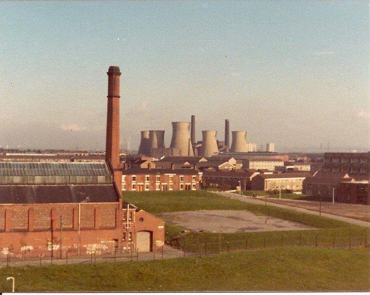
Bradford Power Station, east Manchester in 1976


I have to say I have fond memories of east Manchester.

We lived there for just a year from 1973 to’74 in one of the flats which had once housed the families of fireman.

Our back windows looked out on the old yard which had  held the ambulance and fire engines at the rear of the Mill Street Police station.

From the front windows we could gaze over the stalls of the market to the newly built flats which at night resembled nothing less than an ocean liner all lit up on the night sky.

When we arrived they had yet to demolish the pit head structures of Bradford Colliery and our Sunday afternoon walks came up against engineering factories, steel works and Clayton Aniline.

And when we left we just exchanged a flat off Grey Mare Lane for a house in Ashton and continued to daily pass through the area for another few years.

But by 1976 I was back in south Manchester living in Chorlton and it would be a decade before I went back.  
In the meantime much of that industrial landscape vanished, and now even our block of flats is no more.

So I was pleased when Eileen gave me permission to reproduce these images of the Bradford we knew.  They speak for themselves.
And the correction from Neil Simpson, "I'm sure you know, but the official name of the power station in Bradford was Stuart Street Power Station, built originally by Manchester Corporation and fed slack coal by underground conveyor from the adjacent Bradford Colliery".*

None of which I did, so thanks Neil.
 
To which Philip Gregson added "My Dad's place of work, plus my Uncle Alex. The place where he was definitely happiest, work-wise. Many a happy Christmas party in the staff canteen. Had a few walks round the plant, unofficially of course. 

Taken to see most of the plant, the conveyor from the adjacent pit, the coal crushers, turbine generators etc. 

It was a dominant feature next to Philips Park of course, and in spite of its familiarity, still scared me with its overhead transmission cables crackling in the rain, as electricity tracked across the ceramic insulators. We used to run underneath out of fear. 

I did an article on the station on Manchester History. 

When my Dad passed we drove him to the Station and around the Velodrome (with permission) paused in Stuart St by the main gates. Later scattered some of his ashes in the grounds and in Philips Park formal gardens where he and Mum would visit especially on Tulip Sunday. Happy Days, such beautifully maintained gardens at one time".

And with the comment came this picture of a party at the Power Station to which Philip adds, "I'm RHS, looking left kneeling on chair".

Location, Bradford, Manchester

Pictures;  Bradford Power Station, 1976, courtesy of Eileen Blake, and party at the Power Station, circa 1ate 1950s from the collection of  Philip Gregson

Tuesday, 30 November 2021

Clearing the lot .............. Manchester .... 1967

We are in east Manchester, with two pictures that perfectly sum up the extent of the house clearance programmes of  the middle decades of the last century.

Windcroft Street, 1967
It is easy to take a hard line against the policy that swept away whole communities, along with their streets, homes and identities.

Friends point to the destruction of properties which with a bit of tender care might have lasted for another fifty or sixty years, pointing out that in many cases what replaced the rows of terraced houses were themselves poorly built and badly planned, with the result that they too have vanished.

But there is no doubting that large numbers of the city’s housing stock was past saving, and what we forget is that the policy of clearance and rebuild had been going since the beginning of the 20th century, with the creation of places like Wythenshawe which  pre-dated the last world war.

Ashford Street, 1967
What I never fully understood was the extent to which the rebuilding plans totally obliterated not only the houses, but patterns of streets which had in many cases existed from the early years of the 19th century.

And for a historian that can be frustrating, because having found a location in the historic record it can prove difficult to even come close to finding it, added to which some of the remaining streets had their names changed.

Still it is a small niggle, when set against the destruction of old and tired housing stock, much of which sat in the shadow of factories, iron works, and circumvented by dirty rivers and neglected canals.

And here I have to own up  to getting confused about the location of some of streets, which Paul Forrest kindly pointed out, "Actually it was Bradford/Lower Openshaw and not Beswick although part of the Beswick Electoral Ward. 

When the planners cleared the area in the mid 60s and later built the concrete monstrosity nicknamed Fort Beswick (now also demolished) the planners mistakenly extended the borders of Beswick as far as Grey Mare Lane. I grew up amongst those same streets shown in the photos".

In my defence they wouldn't let me do Geography O level and as a result I fell back on old street directories.  So thank you Paul.  And I shall close with more from Paul.


Windcroft Street, 1967, well a bit of it
"The districts were all quite close together in this part of Manchester; hence I think the reason for the confusion. Beswick extended from Ancoats (Every St) up Ashton New Road as far as Rowsley St and Ardwick extended up Ashton Old Road as far as Blackthorn St where I was born although even my father recorded my place of birth as Beswick! 

I was baptised at St Jerome Ardwick near Rylance Street which was three streets away. Bradford began after Blackthorn St on Blackrock St and from Rowsley St and went up to the border of Clayton on Ashton New Road, and Lower Openshaw on Wellington St off Ashton Old Road where I remember there was a boundary marker sign between the two districts. 

People probably will think I am a bit of a pedant on this matter but I think it important from a historical perspective and old maps show the districts quite clearly. Ashford St may have been in Beswick as I don’t recognise the name after 50+ years, but Windcroft St was in Bradford.

Location; Manchester

Pictures; Clearing the lot, 1967,  "Courtesy of Manchester Archives+ Town Hall Photographers' Collection", 
https://www.flickr.com/photos/manchesterarchiveplus/albums/72157684413651581?fbclid=IwAR35NR9v6lzJfkiSsHgHdQyL2CCuQUHuCuVr8xnd403q534MNgY5g1nAZfY


Tuesday, 17 March 2020

The new east Manchester, pictures from the 1970s


I have been reflecting on those industrial landscapes which many of us grew up in.*

They were a product of the 19th century, continued to dominate many parts of our towns and cities into the 1970s and vanished like snow in the winter sun during the last two decades of the 20th century.

Their going was down in part to town and city planning but mostly to the fairly rapid deindustrialization which saw the end much of our heavy industry.

Most of the factories, mills and warehouses went in a cloud of dust and debris leaving wide open spaces we now call “brown sites” and some with imagination or not so good imagination in to flats for those seeking a new inner city experience.

What also went were the old rows of terraced housing replaced by new social houses and flats.  But as these went up the factories were coming down presenting the newly re-housed families with a bleak future.

Some of that change was caught in a series of pictures by my friend Eileen Blake.  They are a remarkable record of east Manchester in the 1970s.  Here are the new schools and housing estates, nestling beside the older terraced houses and still dominated by the remnants of the old industry, including the gas works and power station.

Pictures; from the collection of Eileen Blake

*http://chorltonhistory.blogspot.co.uk/search/label/Industrial%20landscapes