Showing posts with label St Andrew's Square. Show all posts

Sunday, 17 May 2026

The lives behind the doors ….. numbers 2-14 St Andrew’s Square

Now, it has become quite popular to take a house and tell its story over time.

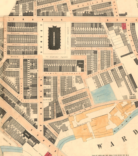
St Andrew's Square, 1849
Long before a certain television series did just that with a property in Liverpool, I had done the same for our house in Chorlton, along with the two I grew up in, in south east London, and the home of our Josh and Polly who live in Leicester.

And over the years I have dipped into the history of heaps of houses, including Homer Street and Coronation Square, both of which were in Ancoats and which were developed in the late 1830s.

Back then the area was just beginning to change from what one account described as a place “of fields [where] the waters of the River Medlock which are close by ran pure and sweet and were the home of beautiful trout.” *

Within a generation the fields had been covered with mills, factories, foundries and dye works along with mean terraced housing and the Medlock began its long association with filth and pollution.

The area, 1819

And so to the challenge laid down by Bob and Del Amato to find out about what was there on the site of what is now their business. **

The warehouse of Amato Food Products stands on what was once a row of fourteen terraced houses which faced St Andrew’s Church. 

I can’t be exactly sure when the square was developed, but the church was opened in 1831 but by 1839 the properties show up in the rate books.

Eighteen years earlier according to Johnson’s map of 1819 the area up from the river to the canal was still open land although already it was edged with buildings.

St Andrew's Square, no 2 at the bottom, 2021

But the 14 properties along the southern side of the square were a cut above their neighbours .

The houses consisted of five rooms and they commanded a weekly rent of just over 5 shillings, which is higher than the surrounding streets.

And many of the residents were drawn from the skilled working class, including a railway clerk, a tailor, a dressmaker and a bookkeeper, along with a salesmen, painter and book keeper.

Their origins were as varied as their occupations with a fair few having come from Scotland, Yorkshire and the Lakes, with others from Cheshire as well as Salford.

I could have picked any of the 14 homes but ended choosing no. 2 St Andrew’s Square for no other reason than it was the first in the row as entered the square from St Andrew’s Street.

Today it is the western end of the Amato warehouse, but in 1851 it was home to Mr. and Mrs. Cruickshank, and their five children, Elizabeth, May, Emma William and James.

Mr. Cruickshank was 43 years old, had been born in Manchester and gave his occupation as a Miller.  His wife Hannah was three years younger and was from Salford.  Three of the children were born in Chorlton on Medlock and the youngest in Oldham, and despite the fact that they ranged in age from 20 down to 13, only William who 15 is listed as working.

Looking east along the square, 2021

I doubt that any of them had attended the school at the other end of the square but certainly some of the children from the other houses will have done.  

The school appeared in an earlier blog story but deserves to be revisited.***

What is interesting is that the square does not appear in the street directories until the beginning of this century, by which time our house was occupied by Samuel Boole who was a labourer for Manchester Corporation, his wife Ethel, their five children and Ethel’s mother.  

Like many families of the period, they appear to have moved across the city, and we can track their movement by where their children were born. The eldest of the children was born in Chorlton-on Medlock and the rest in Ancoats.

In time I shall dig deeper into the stories of both the Boole family and the Cruickshank’s, as well  the occupants of the other thirteen houses.

Inside the warehouse, 2021

All of which just leaves me to ponder on what remains may lie below the warehouse.

Location; Ancoats

Pictures; St Andrew’s Square, 2021, courtesy of Angela Wallwork, and St Andrew’s Square in 1849, OS map of Manchester and Salford, 1844-49,  and the area in 1919 from Johnson's map, courtesy of Digital Archives Association, http://digitalarchives.co.uk/

*Commemorative Booklet, St Andrews Church Ancoats, 1831-1931

** Amato Products Ltd, https://amatoproducts.co.uk/

***Looking for the lost ...... one street over time in Ancoats ..... no 4 the school by Homer Street https://chorltonhistory.blogspot.com/2020/07/looking-for-lost-one-street-over-time_7.html


Wednesday, 17 September 2025

The hatter, the policeman’s wife and a nice line in tapenade, and fresh pasta …….. stories from St Andrew’s Square

I doubt I would ever have explored St Andrew’s Square if I hadn’t taken up the invitation of Bob and Del Amato to visit their food warehouse.

St Andrews Square, 1851

I knew the square and had wandered past it but had never stopped even to stare at what had become a car park and a home for light industry.

The square is one of those little bits of half forgotten Ancoats, which long ago lost its residents, it’s church, and its school.

The residents began to go in the clearance programmes of the 1930s, the school followed sometime later, and by the end of the following decade the church stood alone, until it closed in 1958.

A few years ago I did some work on Homer Street which backed on to St Andrew’s Square and had fully intended to widen my research but never did.*

And so today I have decided to rectify that  omission.  

The square is actually just an L shape which takes up the south and east side of the site of St Andrew’s Church.

I can’t be exactly sure when the square was developed, but the church was opened in 1831 and by 1839 the properties show up in the rate books.

St Andrew's Church, 1964

And just eighteen years earlier on Johnson’s map of 1819 the area up from the river to the canal was still open land although already it was edged with buildings.

St Andrew’s Square, along with Homer Street seems a cut above some of the other streets.

The houses consisted of five rooms and they commanded a weekly rent of just over 5 shillings, which is higher than the surrounding streets.

And many of the residents were drawn from the skilled working class, including a railway clerk, a tailor, a dressmaker and a bookkeeper, along with a salesmen, painter and book keeper.

Their origins were as varied as their occupations with a fair few having come from Scotland, Yorkshire and the Lakes, with others from Cheshire as well as Salford.

So I know that Margaret Mills at number 16 St Andrew’s Square, who was married to a police constable, came from Scotland, and shared her home with seven others, including a nephew, a niece, her father, sister in law and two lodgers.

And not to be out down, her neighbour, Mr. Maddoy the hatter, shared his house with his wife his sister inlaw and her three children, all of whom were engaged in the hat industry.

The plan will be to follow the square’s fortunes over the next century and a bit, charting the different families who lived there, the changing use of the land, and the changes over the last few years.

St Andrew's Square

Which leads me back to Amato Foods, because their site was for a while a sheet metal works, before it became site was used as a vehicle repair centre by the post office, and now a food warehouse.

And I am indebted to Bob and Del for sharing the survey that was undertaken on their site and which offered up some  interesting insights to the the previous occupants.

But more about them, along with the story of the church and the school another time, leaving me just to mention the wonderful tapenade and fresh pasta which Amato Foods make in the premises, along with their delivery service offering a range foods that can be delivered to the door, but I wont because that would be advertising, so I shall just direct you to the links.**

Location; St Andrew’s Square, 

Pictures; St Andrew’s Square  in 1851, from Adshead map of Manchester 1851, courtesy of Digital Archives Association, http://digitalarchives.co.uk/, St Andrew’s Square, 2021, courtesy of Amato Food Products, and St Andrew’s Church, 1964, T Brooks, m10604, courtesy of Manchester Libraries, Information and Archives, Manchester City Council, http://images.manchester.gov.uk/index.php?session=pass

*Homer Street; https://chorltonhistory.blogspot.com/search/label/Homer%20Street

** Amato Products Ltd, https://amatoproducts.co.uk/ and to order, info@amatoproducts.co.uk

Sunday, 15 September 2024

Looking for the lost ...... one street over time in Ancoats ..... no 7 St Andrew’s Church

The story of one street in Ancoats, and the people who lived and worked there.*

One hundred years of St Andrew's
Homer Street nearly made its 100 birthday but the passage of time and a grand slum clearance plan did for it sometime just before 1938.

Its parish church which was St Andrew’s survived for another three decades before it too was demolished.

The church had opened in 1831, and according to one account had been built in “the midst of fields [when] the waters of the River Medlock which are close by ran pure and sweet and were the home of beautiful trout.” **

At the time “the congregation of St Andrew’s was in its early years a fairly comfortable middle-class body, [with] most of the pews in the church being privately rented by people of substance. But by the middle of the century it was surrounded by rising Lancashire industry and black slums filled the parish."***

Inside St Andrew's, date unknown
Surprisingly within just thirty years after it was built and not long after the creation of those “black slums”, the population of the area was in decline.

But it would be Corporation’s slum clearance programme which finally depopulated the area.

So much so that he vicar of St Andrew’s described the area in 1939 as one of “debris and desolation.”

And yet so loyal was the former congregation that many who had been moved out to estates in the north of the city and Wythenshawe in the south returned to attend services, including the popular Sunday School.

St Andrew's date unknown
In 1931 the church had produced a commemorative booklet, which makes fascinating reading.

What I didn’t know was the church also issued a set of souvenir porcelain to mark the event.

And for the picture of these I have Kath Kelly Hughes to thank who saw an earlier story about Homer Street and posted the picture on social media along with two of the church before its demolition.

She added “ I attended St Andrews Sunday school it's a part of my childhood”.

Sadly the site of the church is now an overgrown bit of discarded land, which for a while was home to industrial units.

I think the spot deserves better.

All of which is just a start I hope of a whole set of new stories.

To which I can add that having approached the city Councillors for the area moves were in hand to improve the area.


Pictures; commemorative porcelain, and pictures of St Andrew’s courtesy of Kath Kelly Hughes


*Homer Street,  https://chorltonhistory.blogspot.co.uk/search/label/Homer%20Street

**Commemorative Booklet, St Andrews Church Ancoats, 1831-1931

***A Centenary in Ancoats, St Andrew’s School, Manchester Guardian, June 13 1936

Saturday, 19 February 2022

Ghost streets …….. and the onward march of the cranes

Now it seems everywhere you look there are those cranes which relentlessly march across the city, leaving in their wake a mix of tall residential and commercial towers.

The onward march of the cranes, Travis Street, 2022
You encounter them on the main roads into the city, west into Salford, all over the Northern Quarter and now in ever larger numbers in the shadow of Piccadilly Railway Station.

And it is of that area around Fairfield Street, north towards Travis Street and the site of St Andrew’s Church, and south beyond the great railway viaducts that I want to write about.

But before anyone leaps to their keyboard to call down wrath on the cranes and the developers, historically this is but a new round of urbanization which had already covered the area with narrow streets, mean houses and a variety of industrial units from mills to foundries, and dyeworks, interspersed with timber yards.

My copy of Adshead’s map of Manchester from 1851 clearly shows the degree to which 19th century speculative builders had created a densely packed network of streets and courts, which nestled beside those factories and hemmed in by railway lines, canals and the river.

From the river to the Square, 1851

For over four decades I have been fascinated by their history and keep coming back to the stories of the houses and the people who lived there. *

Of course, they have all gone, swept away by a mixture of municipal house clearances over two centuries, further helped by Mr. Hitler’s bombs, along with the grand plans of the railway companies which cut a swathe through those streets with their giant railway viaducts.

To which we can add the deindustrialization of the centre of Manchester which saw the mills, dyeworks and foundries close to be replaced by small businesses, car parks and open spaces.

But with a bit of imagination and armed with old maps of the area it is possible to gain a sense of just how many houses existed because much of the street plan still exists.

When the old jostles with the new, 2022
So there are still a heap of tiny narrow streets branching off Fairfield Street,  St Andrews’ Square and Travis Street.  

They may have lost their buildings but the sheer number of them brings home the density of the area.

So there is the challenge, all you have to do is wander past Piccadilly Railway Station and plunge eastwards, but do so soon, because within a few years the cranes will have done their job.

Location; east of Piccadilly Railway Station

Pictures; between Travis Street and Fairfield Street, 2022, from the collection of Andy Robertson, and in 1851, 1851 from Adshead map of Manchester, 1851, courtesy of Digital Archives Association, http://digitalarchives.co.uk/

*Fairfield Street, https://chorltonhistory.blogspot.com/search/label/Fairfield%20Street

Homer Street, https://chorltonhistory.blogspot.com/search/label/Homer%20Street

St Andrew’s Square, https://chorltonhistory.blogspot.com/search/label/St%20Andrew%27s%20Square


Wednesday, 10 February 2021

That Ancoats war memorial ….. and some good news

Just a week ago I wrote about the perilous state of the war memorial in St Andrew’s Square.*


It had been erected in 1921 to commemorate the men from St Andrew’s Church who fought in the Great War.

But the closure of the church in 1958, and its demolition three years later left the stone cross increasingly isolated, and over the next sixty years it was pretty much left alone and forgotten.

A large tree threatened the stability of the cross and in the summer months vegetation all but obscured the war memorial.**

I was unsure of who to contact, given that the church authorities had signed off the former church land a long time ago, and so I contacted the relevant elected Manchester City Councillors.

That same day Cllr Sam Wheeler was in touch asking for more details and today his colleague Cllr Jon-Connor Lyons emailed me with the good news that the area had been cut back, and that the Council officers were looking into who owned the land.

So a good start, with the promise that the men of St Andrew’s Church will no longer be forgotten

Location; St Andrew’s Square, Ancoats,

Picture; the wall memorial St Andrew’s Square, Ancoats, 2021, courtesy of Angela Wallwork, Amato Food Products***

*Neglected and forgotten ……. the men from St Andrew’s in Ancoats, https://chorltonhistory.blogspot.com/2021/02/neglected-and-forgotten-men-from-st.html

**Heritage Report, St Andrew’s Church, Lee, Anthony, Report No.SA/2019/12


Tuesday, 2 February 2021

Neglected and forgotten ……. the men from St Andrew’s in Ancoats

I am profoundly saddened at the fate of the war memorial to the 70 men of St Andrew’s

Church in Ancoats, which is in a sorry state.


It was erected in 1921 am along with a tablet which was located inside the church records commemorates the men who fought in the Great War.

The inscription on the cross read, "To the glory of God and in perpetual memory of the Churchmen of this Parish and Congregation who gave their lives in the War, 1914-18, this Cross and the Tablet in the Church are erected by their fellow-churchmen", but the words are now illegible, and as yet I have no idea of the fate of the stone tablet.


The church closed in 1958 and was demolished in 1961, and some where there may be a record of where it went, which I shall go looking for.

As for the cross it is in a perilous state, after sixty years of neglect.  It leans slightly to one side, has lost a bit of the head on its east facing side, and is surrounded by undergrowth and litter.

I can not think that just a few years after that great outpouring of interest in the Great War, which came with a plethora of commemorations, this war memorial stands in such a terrible state, or that its fate is so uncertain.

All of which just leaves me the task of looking for the 70 names on the tablet and trying to bring them out of the shadows.

I have started with an Alfred Pickering who in 1915 was living at 13 Teer Street.  The street is still there off the Ashton New Road , but the houses have long gone.

So far I haven’t been able to locate him for certain on the census return, but I do have this from the National Roll of Honour, which records that he enlisted in 1915 and survived the war.

There are also references to an Alfred Pickering in the Manchester City Battalions Book of Honour, which records that five men with that name were employed by Manchester Corporation Tramways Department, the Co-operative Wholesale Society, Richard Goodiar Ltd of 8 Mosley Street, Charles Macintosh and Co Ltd, and Peter Spencer and Sons.


Not much I know but a start.

Leaving me just to thank Angela Wallwork of Amato Products who took the pictures of the cross on Friday.

Amato Products supply food and other products to restaurants across Greater Manchester and beyond and their warehouse faces on to the site of the demolished church on St Andrew’s Square.


I would also want to thank Anthony Lee, Senior Project Manager (Heritage Management), Salford Archaeology, School of Science, Engineering & Environment, whose Heritage Report on the site of St Andrew's Church prompted the story.****

And that is it while I go looking for the men of St Andrew’s Church …. There are more stories about St Andrew’s Square, and its neighbour Homer Street along with the history of Ancoats.****

But just as I posted the story, Martin H. Prestwich, commented that a tablet commemorating men from the Second World War was removed to the Manchester Miracle Centre, formerly All Souls Church, corner of Every Street and Harding Street, which he writes, is recorded on the "Imperial War Museum website,  https://www.iwm.org.uk/memorials/item/memorial/15901"

That said this host building looks equally empty and I fear the worst.

But Cllr Sam Wheeler of Manchester City council who is one of the three elected representatives for the area, has seen the story and is looking in to what can be done for the cross.  Which is a fine outcome.

Location; St Andrew’s Square, Ancoats,

Picture; the wall memorial St Andrew’s Square, Ancoats, 2021, courtesy of Angela Wallwork, the National Roll of Honour, and the memorial tablet, 1931, courtesy of  Anthony Lee

* St Andrew’s Church Centenary Commemorative booklet, 1931 Manchester Archives & Local History Library, 283.4273.M341

** Amato Products Ltd, https://amatoproducts.co.uk/ and to order, info@amatoproducts.co.uk

***Heritage Report, St Andrew’s Church, Lee, Anthony, Report No.SA/2019/12

**** Ancoats, https://chorltonhistory.blogspot.com/search/label/Ancoats