Showing posts with label Oswald Fields. Show all posts

Tuesday, 4 January 2022

Oswald Field, five cottages, a slice of rural Chorlton, and a bit of a mystery part 1


Today I decided to take a walk along one of the old field boundaries.

But of course as you would expect I have chosen to take the journey sometime in the summer of 1845.  Now this is not as difficult as it would seem and I shall not slide into some fanciful romantic recreation of an idyllic rural spot.

The walk is based on the maps and records of the time, and I want to start with an advert.  It is a little later than 1845, well actually twenty-one years to be  exact but it is a good starting point, because in that year the five cottages and land belonging to Charles Bracegirdle were put up for auction.

It has much to tell us for not only do we have the name of the owner, but also those of the tenants, some of whom had been here in the summer of my walk, and we know their occupations, the rents they paid, and from all this something of what the cottages were like.     But all of that is for later.

The summer of 1845 was mixed.  The earlier part of the year had been cold with “heavy snow falls in March and despite a warm April May had been cold and dull.  June by contrast was fine, but July brought thunderstorms and August was dull cloudy and wet.  Only with September and harvest time did things improve, and the rest of autumn was mild and fairly dry.”*

So this is not the most promising of times to walk a field boundary.  We are on the eastern edge of Oswald Field, which today faces that piece of open land on the corner of Oswald Road looking north and west towards Claridge Road. We know it as Oswald Field, earlier it went by the name of Oswald Croft  and by the early 20th century was part of Oswald Lane, which in those days ran from Oswald Road down to Manchester Road.  And for most of that century it was a narrow little road bounded by the backyards of Claridge Road and Fielden Terrace.

But in the summer of 1845 the lane was in the heart of Chorlton countryside.  Our five cottages stood on the eastern side of the boundary, fairly close to what is now Oswald Road.  In front of them a line of trees only partly obscured views across open land towards the Botanic Gardens, the Duke’s Canal and Trafford.

All around them there were small orchards and woodland, but for the Aldcroft and Barret families who had young children I guess it would have been the ponds which preoccupied them.  There were plenty of these.  Most were the result of digging for marl and clay and within just a short walk there were sixteen of varying size and I guess depth. Some like the large one directly opposite was described as a pond while others were marked as "Marl Pits.”**

Despite the evidence of the marl and clay diggings this was mostly meadow and pasture land and like the rest of the township was rented by a number of different tenant farmers and market gardeners.

So if we had followed the boundary away from the cottages it would have brought us to Red Gates Farm which today is the site of the library and the main road out of the township to Manchester.

Then as now it would have been busy with farmers and market gardeners travelling into the city with food for the markets and itinerant traders and carriers arriving with goods to sell or orders to deliver.  There would also have been that Sunday trade, escaping the confines of industrial Manchester just 4 miles away for a walk with the family in the countryside or visiting our beer shops, pubs and hotels.

Their first port of call might well have been the old Royal Oak, or the beer shop of Mrs Leech, roughly I think where Manchester Road joins the modern Wilbraham Road.  All of which has taken us away from our original field boundary and so is perhaps a good time to stop.

Pictures; advert from the Manchester Guardian, September 16th 1865, detail from the 1841 OS Map of Lancashire courtesy of Digital Archives, http://www.digitalarchives.co.uk/


*Stratton, J.M, Agricultural Records, 1969

**the pond was on that southern side of Oswald Road, now occupied by the six semi detached houses, while the marl pits are now under Oswald Road school.

Saturday, 10 April 2021

Oswald Field, five cottages, a slice of rural Chorlton, and a bit of a mystery part 3


I think this will be the last of the stories on Oswald Field.

Over the last few days I have walked its field boundary, explored the five cottages and tried to discover something of the people who lived there.

But I am content to end with the man who owned the five cottages and just over three acres of land, most of it at Oswald Field but a little on the Row* close to the blacksmith just before the road ran into the green.

And here is the mystery that I have alluded to for despite owning property which qualified him to vote in parliamentary elections he appears not to have owned his own house living instead as a lodger in several homes and variously described himself as a cordwainer [shoemaker], and retired gardener while on his will he is called a labourer and left effects of under £200.

He was born in Great Warford in Cheshire in 1783.  There were Bracegirdle’s in Great Warford in the 1840s and 50s.  One was a farmer, another a book seller and another was a weaver.  Now the place was small enough for him to be related but at present it is an avenue of research I shall leave to someone else.

More promising is his connection with Methodism.  He was at one point superintendant at the Sunday school and some at least of the people he lodged with were Methodists as were two of the men who proved his will.

And it may be that this also gives a clue to when he arrived here in the township.  He is not mentioned as part of the early Wesleyan congregation during the 1820s and the first documented mention of him is 1840 but we may just be able to push that date back.  John Hall who had owned the five cottages on Oswald Field died in 1838 and like Charles was a Methodist.  If the properties passed to Charles on John Hall’s death then either he was already here or settled here around that time.

The income from all the properties and land amounted to £54 a year which is not a substantial amount and will explain why he worked variously as a cordwainer, gardener and labourer.

I doubt that we will ever know his prime occupation and it maybe that some were seasonal or dictated by circumstances.  In the June of 1841 he had been lodging with Joseph Brundrett who was a shoemaker and a decade later he gave his occupation as the same while in 1861 when he was living at Clough Farm he described himself as a retired gardener.

And yet as a man with a vote he was one of a small and significant section of the community.  There were only 27 of them entitled to vote in 1840 out of a total adult population of 341 and given that only men could vote this marked him out as one of only 18% eligible to participate in Parliamentary elections.

And as a Methodist he made up a large proportion of those who could vote in all the elections from 1832 through to 1854. In 1835 just over a quarter of the electorate were Methodists.

They were a close knit group who married into each other’s families lived close together and no doubt discussed the issues of the day.

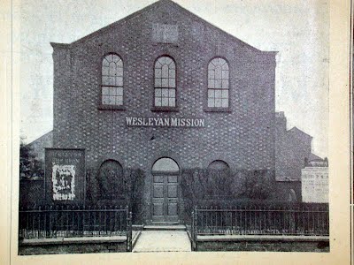
Sadly nothing that Charles said or thought has survived, but we do have his likeness.  It was published in the Wesleyan Church Souvenir Bazaar Handbook for 1908.

It shows a man with a mass of white hair, but even this presents a mystery.  The name below the picture is of a James Bracegirdle, which I take to be Charles.  Again I might be wrong, but there is no record of a James in the township either in this period, or for the rest of the 19th century.  So I guess this must be he, or it may just be another mystery to add to the rest.

Picture; Charles Bracegirdle & the Wesleyan Chapel from Wesleyan Church Souvenir Bazaar Handbook for 1908, courtesy of Philip Lloyd 

*The Row is now Beech Road and his acre of pasture land is today the site of the gated poperties

Friday, 9 April 2021

Oswald Field, five cottages, a slice of rural Chorlton, and a bit of a mystery part 2

Oswald Road

 I  recently walked the field boundary of Oswald Field and today I want to think about the cottages.

There were five of them and they might have looked something like Grantham’s Buildings which stood on High Lane from the 1830s through to the late 1970’s.

I think we can date them from sometime after 1832 and maybe more exactly to around 1835 because in that year a John Hall qualified for a Parliamentary vote here in Chorlton on the strength of owning freehold houses on Oswald Croft.

Five years later the properties appear to have passed to Charles Bracegirdle who is listed in the electoral register for 1840 and with the changed ownership has come a slight change in the name from croft to field.

Red Gates farm, 1845
Now at this point I become a little pedantic.

It is possible that Oswald Croft and Oswald Field are not the same place, but there are no similar properties close by, and the boundary between Oswald Field and High Meadow was in the 1840s known as Oswald Lane, a name it retains till this day.

So I think we can be pretty sure they are one and the same.

But I am not sure of what these five cottages would have been like.

They might like Grantham’s Buildings on High Lane and Brownhill’s Buildings on what is now Sandy Lane have been two up two down properties, but it is equally likely that they consisted of just a single ground floor room with another on top.  There were plenty of one up one down cottages and rows of such across the township.

What I think we can be certain is that they were made of brick.  In the 1840s there were still upwards of fifty wattle and daub cottages but all the new build does seem to have been in brick.  Now I have written about our cottages  and perhaps it is enough to say that they would have been fairly basic, with a brick or slab floor resting directly on the bare earth, a privy and a communal well.

There was a wide disparity in the rents that were paid on the five, with one commanding an annual rent of £16, another £13 and two at £6 and the last at £4.

But I am not sure that this had anything to do with the houses themselves but more to do with the accompanying land.  The higher rented two were described as houses with land while the remaining three were with either “house and garden” or just “house”.

And this fits with the occupations of the tenants.  So Peter Langford who paid an annual rent of £13 in 1845 described himself as a gardener which may mean he derived some of his income from growing food for the Manchester markets.

Certainly he was perceived as a notch up from his neighbours because it is his name which appears as the lead tenant in the properties which allowed Charles Bracegirdle a Parliamentary vote in 1854.

And indeed three years earlier he had described himself as a market gardener on an acre of land.  While others living in the block described themselves as labourers.

Assuming then that the properties were all much the same it might be possible to get some idea of what they were like by comparing rents across the township.

At £6 a year a tenant would have paid 2s 3d or 11p a week while the lower rent of £4 would have worked out at 1s 6d or 7½p a week.  This put them broadly in the middle of the rented properties in 1845.

Rents as % of the total in 1845

Of course this still might hide enormous differences in the quality and repair of the houses but it is a start, and I guess means that our people on the edge of the township were living in homes which were much the same as their neighbours across the township.

And like all our people the length of tenancy seems mixed, some like Peter Langford stayed on Oswald Field for twenty years while others upped and move on in a fairly short space of time which I suspect is another area for some interesting research.

The rate books begin in 1845 and detail landlord and tenant throughout the rest of the century so it should be possible to plot tenancy times.

The last part of the story is still unclear.  Charles Bradshaw died in October 1864 his will was published in the following January and the houses did not them come to auction until the September of 1865.

I don’t know who bought them but I do know they were gone by 1871. I have yet to find out what happened to the tenants or an exact date for their demolition, but that is all possible.  The rate books for the 1860s will reveal when the date of their going and a trawl of the later census returns will show where the tenants settled.

But that is for another time.  Tomorrow I want to pursue the mystery of Charles Bracegirgdle.

Pictures; Grantham’s Buildings High Lane,  m17675, courtesy of Manchester Libraries, Information and Archives, Manchester City Council, http://images.manchester.gov.uk/index.php?session=pass detail from the 1847 Tithe map of Chorlton-cum-Hardy, advert for the auction of the five cottages and land, Manchester Guardian 1865

Saturday, 25 January 2020

What is in a name? Part 1 .... Oswald Lane and Fielden Avenue


Fielden Avenue today

It is often those little roads in the township which intrigue me most.

Take Fielden Avenue and Oswald Lane, which today consist of just one row of terraced houses and a more recent development.

But track them back over time and there are some fascinating little stories here.

Back in the 1840s Oswald Lane was just that, a small lane running from what is now Manchester Road with fields on either side and a row of cottages just where it now joins Oswald Road.

Oswald Field in 1841
It was known as Oswald Field.

The area was on the edge of the Isles, and already was surrounded by clay and marl pits many of which were filled with water.

Fifty or so years later and Fielden Terrace had been built.

These were a row of houses set back on the east side of what is now Fielden Avenue, and sometime between 1894 and 1903 they were joined by another row of smaller properties facing them.

Here lived some of the people who made up the New Chorlton which had grown rapidly from the 1880s.

People who did not make a living from the land as had the residents in Oswald Field, but were plumber’s warehousemen, sign writers and brick makers.

Oswald lane in 1894
And some were directly involved in the development of that New Chorlton.

Men like Thomas Leah who described himself as a brick maker and will have worked at the brick works which had started up at the beginning of the 20th century along Longford Road.

Or Henry Scott, lathe maker [plasterer] who lived with his family at number 2 and had moved up from London just twenty years earlier.

He has a special connection for me because he built our house and his son Joe was the first to live in the place and who went on to build a lot of the houses around Beech Road.*

Oswald Lane in 1973
All of which a little away from Fielden Terrace, which has continued to reflect the changes that have been going on to Chorlton.

During the Manchester Blitz, it received four fire bombs, and a fifth landing just behind on Oswald Road.**

Since then the big houses on the eastern side have gone, and there has been new build.

Now I rather think this is just the start of more stories on this little bit of Chorlton.

Pictures; detail from the 1841 OS Map of Lancashire  and the OS for South Lancashire, 1894, courtesy of Digital Archives,

*The Story of a house, http://chorltonhistory.blogspot.co.uk/search/label/The%20story%20of%20a%20house

**The Manchester Bomb Maps http://enriqueta.man.ac.uk/luna/servlet/detail/maps2~1~1~342739~123267:Manchester?sort=Reference_Number%2CPage%2CCurrent_Repository

Sunday, 23 June 2019

A correction ………… down at Oswald Field with John Anthony Hewitt

Now, I like the way that stories on the blog are often followed up by contributions by people.

And today I am pleased that John Anthony Hewitt took the time to offer up a personal recollection on a story I ran yesterday, which was all about Oswald Field.*

Anthony wrote,

Hi Andrew Simpson, good story, but I could feel my ears burning. Please allow me to correct an error in your narrative. You have referred to Claridge Road and Fielden Terrace in the same context, but that is not historically accurate. 

It was only during the 1950s that the name of Clarence Road was changed to Claridge Road. 

The 1894 map records Fielden Terrace as mentioned in your story, however, the 1915 map shows the name had changed to Fielden Avenue, a name retained to the present day. 

In fact, I have reason to believe that Fielden Terrace was the name of the road, whereas the row of houses was named Sunnyside. These houses have been demolished and bungalows built as replacement homes. A photograph of Sunnyside, aka Fielden Terrace, below is no m17819 from the ML Collection and dated 1873. 

The houses are numbered left to right 26-2, the house with the street and terrace names is no. 26 (ML has the numbers reversed). My childhood home was no. 22, third from the left. As a further anomaly, all the houses had 3-room cellars, including the coal storage room, except for nos 22-26, which had only 2-room cellars. 

The cellar room at the back of the house had not been dug out with the handed down reason that the space was occupied by a very large tree. Now that I am older and have become more familiar with local history I rather suspect that the real reason may have concerned possible marl pits, although this is no more than a suspicion”.

To which I shall just say thank  you to John Anthony

John Anthony Hewitt © 2019

Location; Chorlton

Picture; Chorlton-cum-Hardy, 2-26 Fielden Avenue, Sunnyside (2-4), 1973 m17819, courtesy of Manchester Libraries, Information and Archives, Manchester City Council, http://images.manchester.gov.uk/index.php?session=pass

* Oswald Field, five cottages, a slice of rural Chorlton, and a bit of a mystery part 1, https://chorltonhistory.blogspot.com/2019/06/oswald-field-five-cottages-slice-of.html

Monday, 26 June 2017

In search of the Black Brook as it flows through Chorlton


It exists that much I know, because it is there in contemporary accounts from the 19th century and even showed up in a joint local authority report on “strategic flood risk assessment.*

It seems to have run along what is Upper Chorlton Road, crossing north of the Library and then out to Longford Hall feeding a largish pond not far from where Longford Road joins Ryebank Road.

Our local historian Thomas Ellwood mentions it in one of his articles in 1885 linking it to a “footpath from West Point to Brooks’s Bar as a means of communication between Hulme and the village, along which a brook ran, afterwards arched over and utilised by Mr. Brooks as a main sewer for his property, which he drained into the watercourse called Black Brook. The brook frequently flooded the footpath during heavy rain, and old William Hesketh, who lived at the Pop Cottage, was often awakened at night by the cries of travellers for help and guidance through the water.”**

And just a year later turns up in a letter to the Manchester Guardian from a T. Clarke of Athelstone House, High Lane, who drew a connection between the watercourse and “fevers of a malignant character.” “If you take the Manchester Road, in the Black Brook, immediately by the ‘Oswald’ you will have a place of danger and offence.  I believe the ‘The Oswald’ has several times been visited by fevers of a malignant character”***

‘The Oswald’ or Oswald Field was roughly a little north of the library and extending to Oswald Road. From the early 19th century there was a row of cottages here and by the 1880s Oswald Lane ran from Manchester Road up to Oswald Road.

Today only the little stretch of that original Oswald Lane from Manchester Road survives having been re cut in the 1980s, but its old route is preserved in the footpath which continues on to join Oswald Road.

Looking at the 1841 OS it is possible to see the course of the Black Brook, hugging the edge of Oswald Field before running into the biggish pond and onto Longford Park.

By then it was fully culverted. Tracking it back further east is difficult.  It flowed for a while along what id Manchester Road and must have headed north to towards Upper Chorlton Road, but this would take it directly across the path of Longford Brook.

And that is the problem.  That wonderful book The Lost Rivers of Manchester by Geoffrey Ashworth mentions a Black Brook but that is much further east and any way becomes Cringle Brook out by Burnage which leads me to another communication with the Environmental Agency and a closer scrutiny of the SFRA document.

Meanwhile someone will write in to tell me the exact course and the mystery will be solved.

Picture; Oswald Fields, from the OS map of Lancashire, courtesy of Digital Archives, http://www.digitalarchives.co.uk/

*Manchester City, Salford City and Trafford Councils Level 2 Hybrid SFRA, Maps Index, Final March 2011
**Thomas Elwood, History of Chorlton-cum-Hardy, Chapter 6, Roads, December 12th 1885
***The Sanitary Condition of Chorlton-Cum-Hardy, Manchester Guardian May 19th, 1886.

Wednesday, 12 March 2014

What’s in a name? ........ Part two, fifty years in the story of Oswald Lane and Fielden Avenue

Oswald lane in 1961
Now as much as Oswald Lane and Fielden Avenue fascinated me I have to admit I had not walked down either of them for a long time.

So when I decided to write about them recently it was to revisit how they had changed from the country lane that was Oswald Lane and the fields where Fielden Avenue now sits.

Back them the land was a mix of “ponds and waste”, the gardens and cottages which stood beside Oswald Field and the "wood and pond" worked by Mary White.

Oswald Lane today
And in the course of doing the research I went down to Manchester Road and followed the meandering Oswald Lane past the end of Fielden Avenue and on to where the lane joins Oswald Road.

The houses that backed on to the northern side of the lane have gone and the lane itself has been repositioned to turn at right angles and join Claridge Road leaving the old line of the lane as a narrow footpath which I suspect was pretty much as it was back in the 1840s.

Now as I never tire or telling people I do have a habit of travelling the old lanes and roads of Chorlton as they might have been in the mid 19th century so to walk that footpath just west of Fielden Avenue was a tad like it might have been in 1840.

Oswald lane in 1973
Well just a tad and before any one accuses me of romantic speculation based on a vivid imagination I will close.

And leave you with another image of Oswald Lane, this time in 1973, just three years before I would wash up here in Chorlton.

Pictures; Oswald Lane, 1961, A H Downes, M18075, and in 1973, H Milligan, m18155, courtesy of Manchester Libraries, Information and Archives, Manchester City Council, http://images.manchester.gov.uk/index.php?session=pass and part of the footpath once Oswald Lane today from the collection of Andrew Simpson

Sunday, 27 May 2012

Coming soon, Oswald Field, five cottages, a slice of rural Chorlton and a bit of a mystery


It started as a simple story of five cottages on the edge of the township, and turned into something much more.  They were the homes of gardeners, and shoemakers and might seem nothing very remarkable but they are full of our history, and have a bit of a mystery.

And while they were demolished sometime in the 1860s they have left their foot print just off Oswald Road to this day.


Picture; detail from the 1841 OS map of Lancashire by courtesy of Digital Archives,http://www.digitalarchives.co.uk/ /