Showing posts with label Ancoats in the 1850s. Show all posts

Monday, 15 June 2026

Pushing water up a hill …… looking for Mr. Mills in 1851

 Sometimes you know you are on a loser, but a mix of curiosity and a bit of stubbornness allied to the sheer fascination of digging deep into the past won’t allow you to stop.

John Broome and Jonathan Mills, 1828
And so it was with John Broome and Jonathan Mills who I first came across in a court case in 1828.

They were alleged to have taken part in a very nasty piece of vindictive bullying against a fellow apprentice in the Soho Iron Works in New Islington.

So far I haven’t been able to find out their fate at the Quarter Sessions only that they had both been ordered to find “sureties of £20 each to answer to any indictment at the sessions which having found, they were discharged”.*

Now £20 was a lot of money and there is no indication as to how they raised it.

But that was enough to set me off.

Not that I expected I would find out much.

After all we were dealing with two young men in 1828, who might not have lived long enough to make it into either the 1841 or 1851 census, and who any way could have moved away from Manchester or just slipped through the historical records.

Arthur Street, 1851

And it wasn’t a promising start because there wete plenty of John Broome’s in Manchester in the 1850s, but none quite fitted the profile.

Johnathan Miller was a tad different, because I found a Johnathan Miller on both the 1851 census in the Rate Books. This Mr. Mills gave his occupation as “Mechanic” and his age of 42 would have meant he was 19 in 1828, so just possibly still an apprentice.  
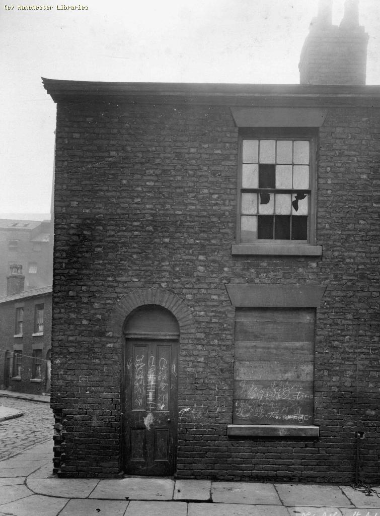
6 Arthur Street, 1901
He was living at 12 Arthur Street with his wife and three children in the heart of Ancoats, surrounded by textile mills engineering works and other industrial premises, all of which used machine power and in turn would have employed mechanics.

The family had been there from at least 1845 and were still there eight years later.  A decade later the family on Ashton New Road in Audenshaw and he described himself as a “labourer in a Chemical works”.  

I doubt we will ever now why he slipped down from a skilled job to being a labourer and while it is attractive to speculate it will not get us anywhere.

Of course this whole trail is based at present on two census returns and the assumption that this is our man, and that is a big assumption.

But the search did reveal a little bit about Arthur Street, which was bounded on two side by the River Medlock and on a third side by a railway viaduct and was located to the south of Fairfield Street closes to London Road Railway Station. 

It is now under the new development which is Mayfield. 

The family were paying a weekly rent of 3/8d and the maps of the period and a series of photographs taken around 1900 suggest that they were two up two down terraced properties.

Back of 6 Arthur Street, 1901
So a step up from the back to backs which many occupied but sufficiently close to the river and heavy industry to have offered little in the way of green verdant pastures.

And there the search for Jonathan Mills peters out,  reminding us that even if this is our man plenty of that water has flown back down the hill to make him and his family pretty obscure.

Location; Manchester in the mid 19th century


Pictures; extract from the Manchester Guardian, 1828, deatil of Adhead’s map of Manchester in 1851, courtesy of Digital Archives Association, http://digitalarchives.co.uk/, the site in 2023, courtesy of Goggle Maps, and 6 Arthur Street, m10771, Back of 6 Arthur Street, Bradburn A,m10771, Back of 6 Arthur Street, Bradburn A,m10772 courtesy of Manchester Libraries, Information and Archives, Manchester City Council, http://images.manchester.gov.uk/index.php?session=pass

Arthur Street, now part of the Mayfield development, 2023

*Manchester Guardian, July 5th 1828

Sunday, 17 May 2026

The lives behind the doors ….. numbers 2-14 St Andrew’s Square

Now, it has become quite popular to take a house and tell its story over time.

St Andrew's Square, 1849
Long before a certain television series did just that with a property in Liverpool, I had done the same for our house in Chorlton, along with the two I grew up in, in south east London, and the home of our Josh and Polly who live in Leicester.

And over the years I have dipped into the history of heaps of houses, including Homer Street and Coronation Square, both of which were in Ancoats and which were developed in the late 1830s.

Back then the area was just beginning to change from what one account described as a place “of fields [where] the waters of the River Medlock which are close by ran pure and sweet and were the home of beautiful trout.” *

Within a generation the fields had been covered with mills, factories, foundries and dye works along with mean terraced housing and the Medlock began its long association with filth and pollution.

The area, 1819

And so to the challenge laid down by Bob and Del Amato to find out about what was there on the site of what is now their business. **

The warehouse of Amato Food Products stands on what was once a row of fourteen terraced houses which faced St Andrew’s Church. 

I can’t be exactly sure when the square was developed, but the church was opened in 1831 but by 1839 the properties show up in the rate books.

Eighteen years earlier according to Johnson’s map of 1819 the area up from the river to the canal was still open land although already it was edged with buildings.

St Andrew's Square, no 2 at the bottom, 2021

But the 14 properties along the southern side of the square were a cut above their neighbours .

The houses consisted of five rooms and they commanded a weekly rent of just over 5 shillings, which is higher than the surrounding streets.

And many of the residents were drawn from the skilled working class, including a railway clerk, a tailor, a dressmaker and a bookkeeper, along with a salesmen, painter and book keeper.

Their origins were as varied as their occupations with a fair few having come from Scotland, Yorkshire and the Lakes, with others from Cheshire as well as Salford.

I could have picked any of the 14 homes but ended choosing no. 2 St Andrew’s Square for no other reason than it was the first in the row as entered the square from St Andrew’s Street.

Today it is the western end of the Amato warehouse, but in 1851 it was home to Mr. and Mrs. Cruickshank, and their five children, Elizabeth, May, Emma William and James.

Mr. Cruickshank was 43 years old, had been born in Manchester and gave his occupation as a Miller.  His wife Hannah was three years younger and was from Salford.  Three of the children were born in Chorlton on Medlock and the youngest in Oldham, and despite the fact that they ranged in age from 20 down to 13, only William who 15 is listed as working.

Looking east along the square, 2021

I doubt that any of them had attended the school at the other end of the square but certainly some of the children from the other houses will have done.  

The school appeared in an earlier blog story but deserves to be revisited.***

What is interesting is that the square does not appear in the street directories until the beginning of this century, by which time our house was occupied by Samuel Boole who was a labourer for Manchester Corporation, his wife Ethel, their five children and Ethel’s mother.  

Like many families of the period, they appear to have moved across the city, and we can track their movement by where their children were born. The eldest of the children was born in Chorlton-on Medlock and the rest in Ancoats.

In time I shall dig deeper into the stories of both the Boole family and the Cruickshank’s, as well  the occupants of the other thirteen houses.

Inside the warehouse, 2021

All of which just leaves me to ponder on what remains may lie below the warehouse.

Location; Ancoats

Pictures; St Andrew’s Square, 2021, courtesy of Angela Wallwork, and St Andrew’s Square in 1849, OS map of Manchester and Salford, 1844-49,  and the area in 1919 from Johnson's map, courtesy of Digital Archives Association, http://digitalarchives.co.uk/

*Commemorative Booklet, St Andrews Church Ancoats, 1831-1931

** Amato Products Ltd, https://amatoproducts.co.uk/

***Looking for the lost ...... one street over time in Ancoats ..... no 4 the school by Homer Street https://chorltonhistory.blogspot.com/2020/07/looking-for-lost-one-street-over-time_7.html


Wednesday, 20 August 2025

The Prince’s of Loom Street ……. lost streets of Manchester no. 97

History has not been kind to Loom Street in Ancoats or for that matter Naval Street, Cotton Street and Elizabeth Street.

Cotton Street, 2023
These were the narrow streets you would have encountered in the space between Oldham Road to the north and Great Ancoats Street to the west.

Loom Street never featured in any of the early street directories and now parts of it have been relegated to a car park while its eastern section is underneath a modern set of industrial units.

And when it did appear in the 1911 directory, the only entry is for one firm at no. 8 which was “Wansker, David, trimming manufacturers” .

All of this despite the fact that in the mid-19th century it consisted of 116 houses, many of which were small back-to-back cottages and the street let out in to 14 closed courts of various sizes.

But then I am not surprised given that a section of Blossom Street which ran parallel was renamed Naval Street, and nearby Elizabeth Street has vanished under a non-descript brick slab.

Back in the 1970s Loom Street came to the attention of the Manchester Historical Association who produced a pack of original source material about the street and focusing on one family.  

The pack was designed to be used in the classroom introducing school students to the skill of interrogating documents and using them to build a picture of life in a working class part of the city during the middle decades of the 19th century.

Loom Street and Murray's Court, 1851
I long ago lost or gave away my copy and as yet I haven’t been able to track down a replacement.  But given that the family were called Prince and they lived in Loom Street in the middle decades of the 19th century, I followed the creators of the pack and went looking for them in the census records and there they were living at no. 9 in 1851.  The Rate Books show that they occupied the house from a decade earlier and were still there in 1857.

They paid a weekly rent of 3 shillings and six pence to the estate of the Earl of Elsmere who had who had an extensive portfolio of properties in Loom Street and the surrounding streets.

I can’t be sure exactly where their house was on Loom Street but I rather think it will have been on the northern side close Cotton Street.  The houses were demolished when St Chad's School on George Leigh Street was extended south and St Michael’s Roman Catholic Church was built next door sometime around 1867. 

Loom Street and St Mary's Court, 1849

And that extension with the construction of the church resulted in the demolition of numbers 1 -9 along with a small, closed court known as Murray’s Court which only a few years earlier had been known as St Mary's Square.

All a tad confusing.  On one level I doubt the loss of these houses caused much of a stir given that some including the home of the Prince’s were small two roomed back to backs.

Murray’s Court consisted of 8 back to backs and access was through narrow passages leading off Loom and George Leigh Streets, presenting us with a location where the sun fought to penetrate the open space, and fresh air struggled against the various smells of close living.

Loom Street and St Michael's RC Church, 1894
The upside of the renovation of the buildings that replaced numbers 1-9 and Murray’s Court in 2016 has been the careful restoration of a wall memorial stone dedicated to the memory of “The Very Rev Thomas Cannon Byrne Rector 1878-1907”, which in time will offer up more research possibilities.

But alas the historical records are less forthcoming about the Prince family after 1857 and to date have offered up no details of the inhabitants of Murray’s Court.

In time something will pop up but not yet. Thomas and Hannah Prince were married in 1830 and both signed their names rather than making a mark. He gave his occupation as a spinner, and two of their five children were also engaged in the textile trade as piecers.

And had you wandered along the street in the 1850s, the majority of those who you might have met were in occupations related to the manufacturer of textiles, while others were labourers or engaged in skilled trades, like dress and makers, some bricklayers and even a Policeman.

Trying for posterity, Naval Street, 2023

Most were born in Manchester or from the surrounding towns with a few from Yorkshire and Ireland.

And few have been remembered by history, if history ever bothered to acknowledge them at all.

Leaving me just to reflect that some of the present occupants of the area have tried to leave their mark on at least one of the forgotten streets.

Location; Ancoats

Pictures; Naval Street, and Cotton Street, 2023, from the collection of Andrew Simpson, and Loom Street in 1849 from the OS map of Manchester & Salford, 1849, in  1851, from  Adhead’s map of Manchester, 1851, and in 1894 from the OS map of South Lancashire, 1894, courtesy of Digital Archives Association, http://digitalarchives.co.uk/


Saturday, 5 October 2024

It ain’t da Vinci …… travels through Ancoats and the canal they stole

An occasional series looking at the less well executed pieces of street art.

It ain't da Vinci, Radium Street, 2023

Well, that is how the story started but as so often happens it took a few twists and turns.

The art is relatively new, and was not there back in 2020, when I last wandered down Radium Street, which is how the story took its first turn, because originally this was German Street and sat along with Bengal Street and Poland Street running from Great Ancoats Street down Union Street and the Rochdale Canal. 

German Street, 1851
And the canal with the Ashton Canal which is a little further south assisted in the development of this area as an important textile manufacturing centre in the early decades of the 19th century.

Many of those cotton mills still exist but long ago became part of that gentrification revolution which saw them converted into residential apartments and smart offices and studios.

Not that I have anything against that development, but along the way, someone stole a bit of the Rochdale Canal.

To be strictly accurate it was a branch of the canal which ran off the main canal just a little east of Poland Street, and then by degree had another off shoot which ran west crossing Radium Street beside our piece of art.

The Bee Hive Mill, 2023

Looking at the picture on the wall it struck me that it stood beside a bridge, but on peering over the causal observer is rewarded with nothing more exciting than an over grown car park.

But back into the 19th century this was an important section of the canal and was boarded by a mix of textile mills, coal yards, the Phoenix Iron Works and the Behive Mill Cotton Mill

School Court, 2023
The coal yards and the Iron Works have long gone, but the Behive Mill which dates from 1824 is still there with its workmanship entrance on Jersey Street.

As is School Court which today is just an uninviting little dead end a little way down from that painting and the remnant of the branch canal.  

Apart from the name there is no other indication that this was the site of St Paul’s Church School which in the mid 19th century is shown on the maps as a substantial building.  

I have yet to find out anything about the building and it has gone by the 1890s, all of which will mean a trip to the archives to track its story.

I suspect if the students of the school had been invited to paint a wall they may well have improved on the 21st century spray can artist.

Well its an opinion.

Radium Street/ German Street, 2023
As for the canal it is less that it was stolen and just filled in when no one wanted it anymore.

Location; Ancoats


Pictures; Radium Street, School Court, Behive Mill, Jersey Street, 2023 from the collection of Andrew Simpson,  and extract from the Manchester Guardian, 1828, deatil of Adhead’s map of Manchester in 1851, courtesy of Digital Archives Association, http://digitalarchives.co.uk/ and Radium Street, 2023, courtesy of Google Maps