Showing posts with label Canals. Show all posts

Saturday, 4 April 2026

That house over the canal ……….. 41 Chorlton Street

Now, I am reunited with a building that has fascinated me for over 52 years.
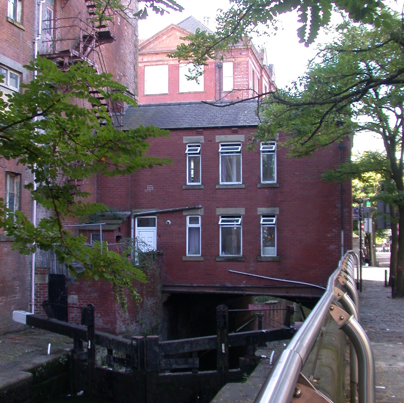
The house in 2016

It is the one that stands on Chorlton Street and straddles the Rochdale Canal.

I always assumed it had once been the home of the lockkeeper, and alternated between thoughts of how cool it would be to live there, with the obvious ones of living directly over a stretch of water on a very busy city street.

Back in the early 1970s it seemed to be unoccupied and as the years went by I had less reason to go down that part of Chorlton Street and just forgot about the place.*

But now I see it appears to be occupied again, and after someone recently asked me about it, the fascination has returned, and with it a mystery.

It does not appear on street directories for the 19th or early 20th centuries, and in 1851 is clearly shown as two buildings, one of which is a warehouse and a place of business and the other residential.

The warehouse and house, 1851

That said a Mr. John Holroyd is listed in the Rate Books for 1863 occupying 41 and 43 Chorlton Street in a property owned by the Rochdale Canal Company.  

All of which was confirmed by a street directory for the same year which describes him as “Lock keeper”.

And as every researcher knows once you have a reference in the historical records, it all comes together.

So, the same Rate Books record the property belonging to the Rochdale Canal from 1847 through into the late 19th century but the census returns stubbornly refuse to record who lived in 41 and 43.

Just occasionally there is a break through and from 1871 through to 1895 and I know that Barton Manchester and his family were there.  

A decade earlier he had been working the canal boats as an assistant, and on the night of the census was with William Wignall and Mr. Wignall’s family on a 50 ton “flat” boat moored on the Dukes Canal.

The house, 1955

He married Elizabeth Baron in 1867 and four years later they were settled in the house over the water.  He described himself as as a waterman.  Ten years later is listed as a “Lock keeper” and he and Elizabeth had a young family with the eldest of the four children aged 7 down and the youngest just 1.

And there the family stay, until his death in 1895.  Elizabeth had died in 1890 and both are buried in Philips Park.** He left £502 and a family that were launched on careers which took them away from the waterways.  The eldest was a clerk to a solicitor, and by 1911 was a “Railway Traffic Regulator", while the others were in various skilled occupations.

In time I will search out their lives, but for now I wll close with what little more I know of Mr. Manchester.  I doubt we will find a reference to his birth or any earlier historical records before 1861.

I know that when he married Elizabeth he was illiterate, giving his mark beside the signature of his wife.  

But there is a clue to that earlier life, and that comes from his first name, which is replicated by another “waterman” who in 1861 was plying another canal, working a boat with his father and family.  He too was called Barton, and I wonder if there is any connection with the aqueduct that carried the Duke’s Canal over the river Irwell at Barton -Upon-Irwell.

The house and canal, 2016

Fanciful perhaps, but possible.

Leaving me just book time to explore the lives of Thomas and Mary Holroyd, Willam Diamond, and Alexander Heap all of whom at some point resided in that house over the canal on Chorlton Street.

To which I can now add this from Hayley Flynn, "I thought you might like some info I found on the house on Chorlton Street over the canal. 

I'm writing a little bit about it at the moment and noticed you'd also been curious over the years - love the occupants you tracked down - Barton Manchester! 

This is the recent update I've written in my article: 

It seems that the Canals and Rivers Trust were the owners of the house until it was sold to an individual, Michael Maybin, in the early 2000s. Maybin continued to live in his flat in Hulme, presumably renting the property out. He died in 2019, evidenced by a police appeal to locate his next of kin; since then the house has remained occupied.

When you look on google maps it's after 2019 that the front of the house has physical changes too, which I guess would signal new occupants but I've not found any new documents relating to the owners so maybe it's still part of his estate".

Location, Manchester

Pictures; 41 Chorlton Street, 2016, from the collection of Andrew Simpson,  British Waterways narrow boats, proceeding to Hassall's Warehouse, Ducie Street, leaving Chorlton Street Lock, 1955, m54248, courtesy of Manchester Libraries, Information and Archives, Manchester City Council, http://images.manchester.gov.uk/index.php?session=pass and 41 &43 Chorlton Street, 1851 from Adshead’s map of Manchester 1851 courtesy of Digital Archives Association, http://digitalarchives.co.uk/


*Little David Street, https://chorltonhistory.blogspot.com/2016/10/lost-and-forgotten-streets-of_14.html

**Philips Park Cemetery, Plot FNon Conformist 426 


Friday, 29 March 2024

Discovering Cromford Canal ……. walks in the Lea Woods ….. no. 2

I collect canals, and today it is the Cromford Canal.

The canal, 2024
It was opened in 1794 and just two centuries later “was acquired by Derbyshire County Council as an Amenity Waterway”.

According to my Priestly’s account of the “Navigable Rivers, Canals, and Railways, Throughout Great Britain”, it was “eighteen miles in length” passed the Codnor Park  and Butterley Iron Walks, traversed the Rivers Amber, Erewash and Derwent and disappeared into several tunnels, before being joined by the Cromford and High Peak Railway just half a mile from Cromford.

Had I been transporting goods in 1830 along the canal I would have been charged “1d per ton per mile for coal, coke, lime and limestone intended to be burnt into lime, and 1½d for iron, iron-stone, lead and other minerals , marble, alabaster, and other stone and timber”.

The canal, 1830

We walked just a short section from the former railway station before turning down a footpath which follows the Lea Brook.

The Pumping Station, 2024

But in that short distance we encountered heaps of industrial buildings, including a Pump House, several outbuildings and plenty of ruined structures, all of which are now part of the collection.

Water and green stuff, 2024
Long ago our bit of the canal to the footpath and been drained and nature in the form of trees and bushes and taken over, but in places the water reappeared and along its length there was still evidence of the stone embankments.

Added to which across the length of the walk there was an abundance of wild garlic which fascinated our Arlo who at 5 was full of harvesting as much as he could.

It is a popular "water amenity" and on a bright warm sunny spring day it was fun meeting a host of walkers along with the couple who oblivious to all of us sat and exchanged a long lingering kiss.

So another to add to the my book of canals, and despite its peaceful appearance this would have been a working canal which terminated not far from Arkwright’s spinning mill which had been opened just 23 years earlier.

And so that is it.

Location; Lea Woods, Cromford

The kiss, 2024

Pictures; walking the canal, 2024, from the collection of Andrew Simpson and a section of the Cromford Canal, 1830 from Bradshaw’s The Inland Navigation of England and Wales, 1830,  courtesy of Digital Archives, http://www.digitalarchives.co.uk/


One of many forgotten buildings, 2024


*Priestly, Joseph, “Navigable Rivers and, Canals, and Railways, Throughout Great Britain, 1830


Thursday, 13 July 2023

Not all adventures end well ......... beyond South Bermondsey looking for green fields

It is just one of those things that the more adventures you have, the more chance that some will turn out to be grim and a disaster which is the reverse of that well known bit of graffiti ...... “You have to kiss a lot of toads before you meet your Prince Charming”.

Me, circa 1959
I will have been about ten and on Saturdays, flush with pocket money I often took myself off down to the station, looking for adventure for just one shilling return.  Sometimes we might push it to two shillings but that ate into the reserves which were for sweets and drinks along the way.

On this occasion we settled on the short journey of one stop from Queens Road to South Bermondsey.  This alone should have been the warning that green fields and wide open spaces were unlikely to be what we found.

To compound it, the day started wet and grey and continued much the same.

But in that sense of adventure that took Marco Polo east to China, and Columbus west to the New World we bought the tickets and travelled north.

I don’t remember much other than on getting out of the station we headed down a long road and found a canal.

Now when you are ten water is fun, whether it is a lake, the River or as in this case a canal.

And I am sure that the Grand Surrey Canal was once a busy dynamic waterway with lots to see and marvel at, but in 1959 great stretches of it had been closed for a decade and a bit.

South Bermondsey Railway Station, 2006
Our bit might still have been open, but it was a dismal spot that we had found.

We took shelter under a railway bridge and watched as the wind drove the rain across the canal, counting the various odd things floating towards us.

And our stay lasted no more than a quarter of an hour and while we ventured a little further along the road from the station, by common consent this had been a failure, .... one to mark down as a toad rather than a Prince Charming.

Recently I have been thinking about that adventure and once went looking for the canal only to draw a blank, forcing me to conclude I had imagined it or mixed two adventures up.

Looking at the map there is no canal any more, just a road, which turns out to be Surrey Canal Road.

And the clue is in the name and the fact that it runs pretty straight from Iderton Road to Fokestone Gardens.

Our bit of the Grand Surrey Canal, 1830
Retracing our steps a full 59 years after our adventure, I rather think we walked down Iderton Road and sheltered under the railway bridge which now crosses Surrey Canal Road.

Since then I have read up on the Canal, which was first suggested in 1801 was opened by 1810 and closed by the 1940s.

In this I was helped by “my Bradshaw”* and the Canal Trio.*

Between them they offer up a fascinating account of our waterways produced when the canals were still at their peak.  And it may be a surprise that Mr Bradshaw not only did railway guides much to Mr Portillo’s  gain, but also Canals***.

His collection of coloured maps of the canal system are wonderful and sit beside the detailed descriptions of each canal company from the work of John Walker, Richard Nicholson, and Joseph Priestly.***

Looking back on the adventure it might have been fun to have had the two canal books with us.

Location; South Bermondsey

Pictures; me about the time of the adventure, 1959 from the collection of Andrew Simpson, South Bermondsey Railway Station, Tom Betts, 2007, on the public domain and detail of the Grand Surrey Canal, going towards Camberwell, 1830, The Inland Navigation of England and Wales 
1830, George Bradshaw courtesy of Digital Archive Association, http://www.digitalarchives.co.uk/

* The Inland Navigation of England and Wales
1830, George Bradshaw

**Historical Account of the Navigable Rivers, Canals, and Railways Throughout The United Kingdom, John Walker, Richard Nicholson, and Joesph Priestly, 1830

*** Great British Railway Journeys is a BBC documentary series presented by Michael Portillo. It premiered in 2010 on BBC Two, and has returned every year for a total of ten series.


Tuesday, 23 February 2021

Tales of past canals …. Shelton Lock and adventures with a narrow boat .... 1947

Now, I have been fascinated by canals ever since I came across a disused one close to where my grandparents lived in Chellaston.


I would have been no more than 10, and the sight of an overgrown waterway with the lock gates hanging at crazy angles as they rotted away from neglect, set me wondering about the purpose of this stretch water.

Of course,  I didn’t think about its history, or its future, after all most 10 year old’s only live in the present, and when I went looking for Shelton Lock just about a decade ago, it had vanished.

It stood by the trolley bus terminus, but after 62 years even the terminus has  gone leaving just the New Bridge Inn as a clue to the canal, which is now a footpath.

All of which is an introduction to Narrow Boat, by L.T.C. Rolt, who recorded a series of canal trips in 1939, at a time when the canal network was in decline.

The volume of traffic had been declining for over half a century and with it was the strong possibility that a way of life which had existed for 170 or so years would also go.

In his introduction he wrote, “Most people know no more of the canals than they do of the old green roads which the pack-horse trains once travelled.  

The canal network around Manchester, 1831

Of all the authors who have written of their journeyings about England, only Mr. Temple Thurston chose to travel by water, and his delightful book ‘The Flower of Gloster’, being published nearly thirty years ago, stands on the small shelf in my library which is sufficient to contain all that has been written on canals.  

For they have lapsed into the  neglected obscurity which overtook the turnpikes when the railway disposed the stage-coach and ruined the great posting house along Watling Street and the North Road.  Now the motor-car has brought the road into its own again, but the canals gave withdrawn still further into the shadows.  

Knowledge of them is confined to the narrow hump-backed bridges which trap the incautious motorist, or to an occasional glimpse from the train of a ribbon of still water winding through the meadows to some unknown destination”.*

The Rochdale Canal, 1979

Which is pretty much where I came into the story in 1959, looking over the bridge at Shelton Lock and wondering at that sheet of still green water, almost entirely hidden by reeds broken only by the odd floating bit of debris.

Fifteen years earlier most of canals were still being used, and this was what allowed Mr. Rolt to borrow a relative’s narrow boat and make a series f journeys, which became the book.

The Rochdale Canal, 2003

But Narrow Boat is not just a catalogue of watery adventures, but a record of the men, women, and children who still worked the canals, and description of their way of life.

There is  a detailed glossary at the back, which includes a definition of a barge and how it differs from a narrow boat and much else.

Added to which there are some fine period photographs and a wealth of images by the artist Eric Gaskell, whose chosen method was the lino cut.

So far, I am only on chapter one, but have also ordered up ‘The Flower of Gloster’, which between them will add to my knowledge of the of a time when many people had turned their back on canals.


And I notice that his map includes the Derby Canal which ran through Shelton Lock, which means I might just get a description of the waterway in happier times.

Leaving me just to say that the canal was closed in the 1960s, but there are plans to excavate it.**

Alas while he got as far as Middlewich, the glories of our own canals in Manchester were a narrow boat too far.

Pictures; from the collection of Andrew Simpson, 1979-2003, map of the canal network around Manchester from Bradshaw’s map of 1830, The Inland Navigation of England and Wales, and the extract from Joseph Priestley’s Historical Account of the Navigable Rivers, Canals, and Railways, 1830 courtesy of Digital Archives http://www.digitalarchives.co.uk/ 

*Narrow Boat, L.T.C. Rolt, 1944 page 11

**Shelton Lock, https://en.wikipedia.org/wiki/Shelton_Lock and The Derby Canal, https://en.wikipedia.org/wiki/Derby_Canal#:~:text=The%20Derby%20Canal%20ran%2014%20miles%20%2823%20km%29,in%201793%20and%20was%20fully%20completed%20in%201796.


Wednesday, 23 September 2020

50 ways to use a gasometer …….. no. 32 a block of apartments

I collect gasometers.  


They are a vanishing collector’s dream, and I have to confess I restrict myself to pictures and stories.

Once every self-respecting town would have its own gasworks and the accompanying gasometer to store the manufactured gas.

As a kid I was fascinated by the telescopic ones, which rose and fell with the amount of gas they held, and have always thought the steel and iron lattice frame which contained them were things of beauty.

But then I never lived next to one.

And today few people do, as increasingly they are redundant and are on the danger list.

Many have gone, but occasionally some have benefited from a bit of imagination, like the surviving ones by the Regents Canal.

Now I have to confess that I have never walked the Regents Canal.

When I was growing up in south east London I had little reason to go and visit it, especially as we had our own near by in the form of the Surrey Canal.

And on the rear occasions we made a visit home, Well Hall and the family offered up all we needed for a holiday.


All of which brings me to “50 ways to use a gasometer …….. no. 32 …. a block of apartments", and my friend Bronwen, who alerted me to the fate of those along the canal.

She was reflecting on our conversation about gas holders and commented “I think there are many older buildings now part of tourist attractions but there is something interesting these re old gas ironworks. We were by Regents Canal not so long ago where they have incorporated the ironworks into apartments.  We came across them as  part of my brother in law's London Walks.*

So, there you have it, I can now add the Regents Canal gasometers to my collection, and for anyone who wants to know more about them, just follow the link to an interesting article from the Hackney Gazette, dated 2019.**

Leaving me just to thank Bronwen for sending up the pictures.

Location; Regents Canal

Pictures; Regents Canal, 2020, from the collection of Bronwen Woods

*info@battlefieldjourney.com, https://www.battlefieldjourney.com/london-walks/markets-kites-and-canals/?fbclid=IwAR3_u_bExcRHhiZ_tJqWWgAlTJccgsUhJkSHS0ueNrXFyC8XHdjuIA1kRKc

**“‘Regent’s Canal gasholders should be turned into a museum, not taken apart’ urges East End Waterway Group’s founder Tom Ridge”, Emma Bartholomew, October 15,  2019 Hackney Gazette, https://www.hackneygazette.co.uk/news/heritage/hackney-history-regent-s-canal-gasholders-1-6321714


Tuesday, 21 July 2020

Lost in Gorton …… part one on coming across a canal

Now Andy is nothing but dedicated, and yesterday he set off to Gorton in search of adventure.

The lost canal, 2020
He had “got up early and went to Gorton. First snap at 7.15 am”.

And I am guessing that sometime around 8.30 he happened on the canal that runs under Abbey Hey Lane.

Today it is just a scenic footpath, but at the back end of the 18th century and through the next, it was the Stockport branch of the Ashton Under Lyne Canal, which ran from Manchester to Ashton and on to Oldham.

According to Mr. Priestley’s Guide,* Royal ascent was granted in June 1792, and the year after permission was also given to “to extend the said Canal from a place called Clayton Demesne, in the township of Droylsden, in the parish of Manchester aforesaid to a place on the turnpike-road in Heaton Norris, leading between Manchester and Stockport, opposite the house known by the sign of the Three Boars’ Head, and from , or nearly from, a place called Taylor’s Barn, in the township of Reddish to Denton to a place called Beat Bank, adjoining the turnpike-road leading between Stockport and Ashton-Under-Lyne …..”**

The canal, 1830
The canal and branches “were made 31 feet wide at top and 15 at the bottom and in a depth of 5 feet.  The locks are 70 feet long and 7 feet wide”.***

And for those with an interest in recreating the business model, in 1792 the company advertised its rates as ½d per ton per mile for lime, lime stone, dung, manure, clay, sand, and gravel, and 1d for coals, cannel coal, stone, and other minerals and timber.  Three years later the rates had risen from ½d per ton per mile to 1d and 3d for all other goods.

The walk, 2020
The Stockport branch was constructed in 1793, and opened for business four years later.

It left the main canal at the Stockport Junction between locks 10 and 11 at Clayton and terminated at Stockport Basin.

It carried a mixed cargo, supplying cotton to the mills along its route as well finished textiles, as well as coal and grain.  In its earliest days it also carried passengers between Manchester and Stockport.

But like so many of our inland waterways it suffered from railway competition, and commercial carrying ceased in the 1930s, and by the 1950s was barely navigable.****

Location; Gorton

Pictures the lost canal at Abbey Hey Lane, 2020, from the collection of Andy Robertson, and the Stockport branch of the Ashton-Under-Lyne Canal, 1830, from The Inland Navigation of England and Wales, George Bradshaw, 1830, courtesy of Digital Archives Association, Digital Archives Association, http://www.digitalarchives.co.uk/


*Map of the Inland Navigation and Railways of Great Britain, Joseph Priestly, 1830

**ibid Priestly page 39

***ibid Priestly, page 40

****Stockport Branch Canal, https://en.wikipedia.org/wiki/Stockport_Branch_Canal

Friday, 17 April 2020

Watersmeet …… Stretford ….. doing the essential walk and making it historic .... no. 1

We each take those “essential walks” in a different way, and in Andy’s case it had to be beside water, and that meant a stretch of one of his favourite canals.

And after that walk was over he shared it with me, adding, “This is where I did my daily exercise today, just happened to have my camera with me”.

Already a friend of his responded, with “Many thanks for lovely photos, keep exercising your camera”.

And I hope he does.

I could have gone into the history of the canal, but that’s been done.*

Location; Stretford


Pictures; Watersmeet, Stretford, 2020, from the collection of Andy Robertson


*Memories of the Duke’s Canal at Stretford, https://chorltonhistory.blogspot.com/2014/05/memories-of-dukes-canal-at-stretford.html

Thursday, 1 August 2019

What’s in the colour of the water? …………….. down with Andy Robertson at the canal

Yep ……… this is nothing more than a water story, occasioned by the recent heavy rain.

July 2019
One of Andy Robertson’s favourite haunts is Pomona, and like so many of us, he is drawn to water.

And so, for no reason other than that I too like canals and water, here are two of those then and now pictures, although I grant you, they are only separated by a few months.

Andy was there yesterday, sent over the images adding “I am sure the canal in Pomona land doesn't always look as brown as it did today”, which led us to speculate on the impact of the amount of rain we have experienced.

April, 2019
That said I bet a full century ago, that same canal would have offered up a full range of colours, depending on what was being discharged directly into it from the many warehouses and factories which lined its banks.


Leaving me just to reflect that "the water ain't what it oughta".*

Location; Pomona

Pictures; the colour of canal water, 2019, from the collection of Andy Robertson

*With a nod and smile to a classic Heineken advert, 1985https://www.youtube.com/watch?v=86CZQGdxyMs

Monday, 7 January 2019

Telling the story of our canals ………… a new book in the making

Now if you were born in the first half of the last century, you will have seen our canal network slowly decline, from a once proud and busy set of waterways, to a dismal, neglected and in places dangerous afterthought.

The Rochdale Canal, 1980
But many are now fully restored and while they may not anymore be used to transport goods, they offer up opportunities for recreation, from those who take to the water in colorful boats to those who walk the water or cycle its paths enjoying the scenery and reflecting on the history.

And all of that, has inspired Peter and I  to write a new book, which will feature the much-loved Cheshire Ring.

Like all the other Topping/Simpson books, it will be a mix of original Peter paintings, contemporary and old photographs, along with stories about the canals, the people who worked on and around them, and the buildings and places of interest which survive along the line of each waterway.

The Rochdale Canal, 1979
The chapters will be designed so that they can be walked, cycled, or sailed, with plenty of places to stop off to take in the sites, or the local hostelries.

At this point we are still in the planning stage, and welcome contributions, which can be stories, photographs or memorabilia.*

For our part Peter has already begun painting some of the iconic buildings on the Ring, and I have started the research, which has taken me back to my favourites which are Bradshaw’s The Inland Navigation of England and Wales, and  Joseph Priestley’s Historical Account of the Navigable Rivers, Canals, and Railways, published in 1830.

Both are full of maps historical background and wonderful descriptions of the network in its heyday.

Added to which there are some fascinating memories from people who describe the canals when they were still working waterways, children who played along the derelict towpaths, and plenty from those who take to water for holidays or the odd weekend.

All of which leaves me to share my own favourite canal which is the Rochdale, which will be well known to those who take it to cross through the city from the Castlefield to the Dale Street Basins.

Manchester Canals, 1830
"The canal is one of the main links in the chain of inland navigation between the east and west seas, being made for vessels of such size as enables them to navigate the tide way, and to pass between Liverpool and Hull without the expense of reshipping their cargoes, thus affording great advantages to the populous towns of Manchester, Rochdale, Halifax, Wakefield and others on the banks of the intermediate rivers. 

The Baltic produce can thus be readily conveyed into Lancashire and the manufacturers of Lancashire in return exported through the ports of Goole and Hull to Hamburg, Petersburg, Lubeck and other continental markets. 


The Rochdale Canal, 2003 
The stone from Cromwell Bottom and its neighborhoods is hereby also conveyed to Rochdale and Manchester. 

These connections are likely to make it ultimately an undertaking of considerable profit to the proprietors.” **

So, our own international highway and one that carried everything from “corn, timber, woollen cloth, coals and raw materials.”

But like all our canals find it difficult to compete with the railways and finally closed in 1952, although the section through the heart of the city from Castlefield to Piccadilly proved profitable and stayed open.

Pictures; from the collection of Andrew Simpson, 1979-2003, map of the canal network around Manchester from Bradshaw’s map of 1830, The Inland Navigation of England and Wales, and the extract from Joseph Priestley’s Historical Account of the Navigable Rivers, Canals, and Railways, 1830 courtesy of Digital Archives http://www.digitalarchives.co.uk/ 

*You can contact us by leaving a comment on the blog, or emailing peter@pubbooks.co.uk or leaving a message at 07521 557888


** Priestley, Joseph, Historical Account of the Navigable Rivers, Canals, and Railways, 1830, Page 579


Monday, 5 January 2015

One to do ............ The Peak Forest Canal talk tomorrow at Furnes Vale

Now canals have always had a special fascination for me and I reckon the talk at Furness Vale History society on the Peak Forest Canal System promises to be a good one.

The illustrated talk will be at Furness Vale Community Centre, Yeardsley Lane, on Tuesday January 6 at 7.30.

Non members are always welcome and admission is £1.50 including refreshments.

*Furness Vale History Society, http://furnesshistory.blogspot.co.uk/