Showing posts with label Chorlton in the 1850s. Show all posts

Friday, 26 June 2026

Mr Gratrix's clay pipe lost in our garden in 1845

The pipe found in the garden, 2014
It is not much of a piece of history but I found it in our front garden which makes it special and takes me back to sometime in the 19th century.

It is a bit of clay pipe and was probably thrown away by some one working this bit of land, or by someone passing along what was then called the Row.*

It is even just possible it came from night soil brought in from Manchester to spread on the fields of Chorlton.

'Like any time in history some of the most revealing clues to how people lived are contained in the rubbish they threw away.  Across the township one of the most common items to resurface is the humble clay pipe.

Found in the parish churchyard, 1980
Usually they are broken and often turn up on their own, although sometimes a whole batch has been unearthed over a period of time all quite close together.

They were the pipe of the working man, and some working women.  

Inexpensive, easy to make and made in huge quantities, they are a true example of a throw away product.  

They were smoked in the home, in the pub and at the work place.  

The evidence from sites in some of the poorer parts of London show that the owners smoked heavily.**

Clay pipes come in many different sizes, some with long stems and decorated bowls and date from anytime from the 17th through to the 20th century.  The last clay pipe manufacturer in Manchester only ceased trading in 1990.

The most interesting pipe to come back out of the earth was found in the archaeological dig of the church in the 1980s.  It can be dated to between 1830 and 1832, and may have been bought to commemorate the coronation of William IV.  


The William IV pipe, 1830-32
It bears the inscription “William IV and Church” around the rim and is highly decorated with the royal coat of arms flanked by a lion on one side and a unicorn on the other.  

It is also unusual because it was found in one of the graves inside the church.  

The final burial in the grave was that of Thomas Watson aged 54 in 1832.  

There are those who might well imagine the pipe being placed alongside the coffin of Thomas Watson in imitation of the ancient practice of placing grave goods alongside the departed.  

The less romantic will counter with the obvious observation that it was the casual act of one of the grave diggers.  

Either way it is unusual for the bowl to survive.   More commonly it is the stem which is turned up and even these are found as fragments.


Detail of the pipe
Clay pipes were never expected to last.  At best they might survive for a few weeks and in many cases just days.  But then they were cheap.  

Very little has been published on the price of pipes but adverts dating from 1799 have unglazed ones selling at 2s 6d [12½p] a gross.  Just over 130 years later the 1930 Pollock catalogue was selling them at 4s [20p] a gross.  Longer pipes did cost a little more but these were not the choice of the working man in the fields.  

Shorter pipes could be smoked while working and it is these that turn up in the fields around the township.'***

So I wonder about my bit of pipe.

I would like to think it belonged to Samuel Gratrix who was farming this bit of Egerton land in the 1840s, but chances are it was discarded by someone passing along the Row, or worse still dropped into a privy somewhere in Manchester, only to make its way with a cart load of night soil along the Duke's canal to Chorlton.

But that along with Mr Gratrix and his field belong to another story.

Pictures; clay pipe, 2014  from the collection of Andrew Simpson, and other pipes from the report on the Archaeological dig conducted by Dr Angus Bateman during 1980-81


*The Row or Chorlton Row is now Beech Road

** Pearce, Jacqui, Living in Victorian London: The Clay Pipe Evidence, 2007, Geography Department at Queen Mary, University of London

***from the Story of Chorlton-cum-Hardy,   http://chorltonhistory.blogspot.co.uk/2011/11/the-story-of-chorlton-cum-hardy.html

Thursday, 25 June 2026

Chorlton farmers ............. Mr and Mrs Bancroft farming at Park Brow from 1841

Now I don’t have a picture of James Bancroft, but given that he was born in 1802 and spent his life at the plough I doubt he would have had the time or the inclination “to sit and be done in oils.”

The gravestone of James and Betty Bancroft
But I know a bit about him and it is enough to take the story of Park Brow Farm into another chapter.

In 1851 he was farming 60 acres of land and living with his wife Elizabeth and their six children in the eight roomed farmhouse on the corner of what is now Sandy Lane and St Werburgh’s Road.

I can’t be sure but I think the family will have moved into the tenancy sometime between 1838 and 1841.

They were originally from Stretford and their last child was born in Stretford in 1838 but three years later they appear on the census return at Park Brow.

And there the family stayed well into the 1880s, by which time James and Elizabeth were dead and the farm was run by their two unmarried daughters.

As Chorlton farms go Park Brow was at the top end of the middling farms.  The very big ones like Barlow Hall Farm at 300 acres and Hough End Hall and Dog House Farm at 240 were big, but there were plenty more that were much smaller and the majority of land holdings were between just 1 to nine acres.

At which point it is worth saying that Hough End Hal and Dog House were actually in Withington not Chorlton.

60 acres  would have made Mr and Mrs Bancroft respectable farmers whose land was split between arable and meadow land.

In 1851 they employed four agricultural labourers of which three lived with them and like the family had all been born in Stretford.

“Living in” was still a common practice in the middle decades of the 19th century and while the labourers got paid less their board, and lodging came free and usually they could expect their clothes to be washed and mended.

Park Brow Farm in 1845
In most cases the agreement lasted for a full year and it was a system which suited both farmer and worker and tended to apply particularly to young employees.

The farmer got the guarantee of a labourer for the year and the farm worker was assured somewhere to stay which was especially important when as was often the case they were still quite young.

So of our three living in labourers in 1851 one was 20, the second 17, and the third just 15 and a decade later the carter Edward Cook and the cowman Isaac Evans were both 17.

Like most of the farms in the township the land belonging to the farm was spread out and so while the Bancroft’s rented land along the north side of what is now Sandy Lane it was interspersed with fields farmed by Thomas Cookson and George Lunt and the rest of the Park Bow fields were off to the south beyond Chorlton Brook.

In time I will go looking for the rest of the family but for now I shall just leave you with that sombre fact that James and Elizabeth’s gravestone in the old parish churchyard survived the developers and can still be seen today.

Location; Park Brow Farm, Chorlton-cum-Hardy

Picture, gravestone of James and Elizabeth Bancroft, Chorlton parish church Yard, 2009, and Park Brow 1845 from the Tithe Map from the collections of Andrew Simpson and Philip Lloyd

Tuesday, 16 June 2026

The lost woods of Chorlton …… and a mystery concerning Mrs Lydia Brown and John Holland

We are looking out on John Holland’s Wood which stretched west along Chorlton Brook towards the Bowling Green Inn.

John Holland's Wood, circa 1900, looking towards Brook Farm

Today the footpath to our left is Brookburn Road which once ran east to Barlow Moor Road and west into the village and then out again to eventually cross Turn Moss to Stretford.

John Holland's Wood, formerly the Cliffs, circa 1900
I can’t be sure exactly when it became known as John Holland’s Wood, but John Holland had taken over the family farm in 1865 on the death of his father. 

The Holland family were farming 54 acres around Chorlton from at least 1841 and their holdings were dotted about the township.

These included a strip of land on Row Acre which was the large field running along Beech Road, a stretch on the northern border beyond the Longford Brook and the delightfully named Back of the World which was located where Chorlton Brook joins the Mersey to the south of the stone bridge.

The Cliffs and Brookburn Farm, 1854
Back then, according to the 1854 OS map the stretch we can see in the picture was more heavily wooded, and was known as the Cliffs, which was rented by Lydia Brown who lived at Brook Farm, and farmed across the township, on land which she owned and land she rented from the Lloyd Estate.  

Added to which she owned the smithy on what is now Beech Road, the property used by the wheelwright, Mr. Brownhill on Sandy Lane and a portfolio of cottages.

We even have a snatch of a conversation she had with the journalist Alexander Somerville who came  to Chorlton-cum-Hardy in the summer of 1847 looking for potato blight, the disease which had ravaged Ireland, and was that summer causing concern in Derbyshire.

He stopped at Brook Farm, and reported his conversation with Mrs. Brown who complained about the ash trees which grew around the fields  “which are not only objectionable as all other kinds are in and around cultivated fields but positively poisonous to other vegetation, and ran through the ground causing much waste of land, waste of fertility, and doing no good whatever.  Squire Lloyd is the landlord.  

Brookburn Farm, circa 1900

Mrs. Brown a widow, is the tenant.  She keeps the farm in excellent order so far as the landlord’s restrictions will allow.  But neither herself nor her workmen must ‘crop or lop top’ a single branch from the deleterious ash trees."

And what is exciting is that we know just which fields she was referring to.  These were Rye Field and New Hey which were plots 317 and 318, and ran beside the woods and today form part of Chorltonville.

Despite not yet finding her on the census record I can track her and her husband across the Rate Books from the 1840s through to the mid 1870s.

The woods and Rye Field, 1845

And here is the mystery, because while Lydia Brown lived at Brook Farm which was roughly on the site of Brookburn School, the Holland family are also recorded at a Brook Farm which was according to the tithe record on the bit of Manchester Road which  for a century and a bit was the Conservative Club.

All of which is compounded by the census records which in 1861 place the Holland farm house  on Brookburn Road.

I will leave it to Eric, and who else cares to attempt an explanation, suggesting only that perhaps Lydia had given up farming by 1861, and was happy to live off the rents from her properties, leaving the Holland family to move closer to the woods which took their name.

Sadly, it is no longer possible to recreate the scene and reproduce an image from roughly the same spot.

The trees have vanished under what is part of Chorltonville and a new residential development which was built on the old dairy.

Location; Chorlton

Pictures; John Holland’s Wood, and Brook farm from the Lloyd collection and the Cliffs in 1854 from the 1854 OS map of Lancashire showing a section of Chorlton-cum-Hardy, courtesy of Digital Archives Association, http://www.digitalarchives.co.uk/ and theTithe map of Chorlton-cum-Hardy, 1845

Friday, 16 May 2025

A chance find and the beginnings of a story on Wilbraham Road

Now this is a story that has yet to find an ending and in the telling will eventually reveal much about how and why Wilbraham Road follows the course it does.

The three proposed routes crossing close to Red Gates Farm
I have always taken this long road which stretches from Chorlton up to Fallowfield for granted.

After all it was cut in the late 1860s and so is pretty much one of the features of the area.

Our own historian Thomas Ellwood writing in 1885 confined himself to the observation that “it was formed some sixteen years ago by the late Lord Egerton, father of the present earl. It extends from Wilmlsow-road at Fallowfield to Edge-lane, along which a main sewer runs to within a short distance of the railway bridge at Chorlton station.  

From here it passes through the fields to Barlow Moor-lane, adjoin Lane-end, crossing High-lane, Cross-road and Beech-road, thence through various gardens, finally emptying itself into the Chorlton Brook at a point about 200 yards below the bridge which crosses the stream to Jackson’s Boat.”

So as far as Mr Ellwood was concerned the road was less interesting than the sewer which ran beside it.

I on the other hand have long been intrigued by why it was built and the benefits it might have brought to the township.

But other than clocking the date it was cut that was about it, until recently when going through the Egerton Papers in the Archives at Central Ref I came across a map showing the proposed route.

It is dated 1853 and actually shows three possible routes all to the west of the current line.

The description is less than helpful confining itself to just “plan of projected new road from Rusholme to Stretford” and there are no accompanying notes.  Now these may be elsewhere in the papers and so I will have to go off and look.

And until I find those notes I cannot be sure why three routes are shown.  All three are close together.

The first marked in blue would have crossed Martlege just below Red Gate Farm where the Library now stands and the other two coloured in brown and red just a little further to the west and two would have involved crossing Longford Brook.

Martledge, Renshaw;s Buildings now the the Royal Oak
Now why none of these routes was chosen is as yet unclear, there may have been issues with the land especially around the Isles** or it may it may have been because they ran close to Red Gate Farm and crossed Longford Brook.

All of which is one of those little bits of history yet to be uncovered.

That said the map is a wonderful source of information about the outer reaches of the township showing each of the properties and the fields, and natural features either side of the proposed routes.

So along with searching for more on the planned road I will be returning to our 1853 map.

Picture; detail from the plan of projected new road from Rusholme to Stretford, Egerton Papers, M24 /1/15 1853, courtesy of Manchester Libraries, Information and Archives, Manchester City Council, http://www.manchester.gov.uk/info/448/archives_and_local_history

*Egerton Papers, M24 /1/15

**Ellwood, Thomas, L, Roads and Footpaths, Chapter 6, History of Chorlton-cum-Hardy, South Manchester Gazette, December 12 1885

***this is the area abound Longford Road which was popularly known as the Isles and was dominated bt small lazy little water courses feed ponds and pits which had been dug to extrach clay and marl

Saturday, 3 February 2024

The tree …… Marsh Leach Meadow and Mr. William Whitelegg

So, it started with a picture of the tree on Manchester Road beside the bus stop and the Co-op Undertakers.

Tree shapes, 2022

It isn’t a particularly old tree, although someone with more tree knowledge might correct me.

But it got me thinking about what this stretch of Manchester Road would have been like in the middle of the 19th century.

And yes, the OS map for 1854 shows a line of trees advancing up along the road from Longford Brook to Dark Lane.

Manchester Road, 1854
Inconveniently back in 1854 our tree was not there.

This I know because both the 1854 map and the slightly earlier tithe map show the road treeless as as far as Red Gates Farm up to the Longford Brook. 

They were Egerton land and farmed by William Whitelegg who lived at Red Gates Farm which is now the site of the Library.

The two fields were called Long Field and Hulme Marsh Leach.

Long field was farmed as pasture and its neighbour Hulme Marsh Leach was a mix of arable and meadow land.

While opposite on the other side of the road were King High Marsh, Horse Field and High Meadow which were arable and meadow.

You won’t find Longford Brook, it had already been culverted by 1854 while Dark Lane is now Buckingham Road.

And these too were farmed by Mr. Whitelegg who in total rented 68 acres and could include in the roll call of field names, Gilbury Marsh, United Field, Brick Croft Barn Pit,  and Long Dog Platt.

Along with an orchard of 2 acres and a small garden where he grew a selection of fruit destined for the Manchester markets.

Location; Chorlton

Picture; Tree shapes, 2022, from the collection of Andrew Simpson and Manchester Road, 1854, from the OS map of Lancashire, 1854, courtesy of Digital Archives Association, https://digitalarchives.co.uk/

Additional material from the Tithe Schedule, 1845

Friday, 26 January 2024

Princess Road …. Chorlton-cum-Hardy …. two mysteries .. only one solved

Princess Road was off Neale Road and is now Pinewood Road.

Princess Road, 1933
I came across it while searching for something else, and it was one of those niggling little mysterious which needed solving. 

It is there on the 1901 census and  in the Rate Books for the 1870s.

So far so good, it just became a matter of tracking exactly where it was in  Chorlton-cum-Hardy.

The 1911 street directory recorded that it was off Neal Road, which was confirmed by later maps.

But what makes it a little more interesting is that its name was changed in advance of the big cull on repetitive street names across the city which saw Regent Road become Reeves, Church Road turn in to Chequers, and the demise of countless other old Chorlton road names.  

Most appear to have happened in the late 1960s or early 70s, but not so Princess Road which had bucked the trend and become Pinewood sometime between 1933 and 1956.

All I suspect a little nerdy which I fully accept, but for another mystery which is its appearance in the Rate Books for 1870s.

It appears just the five times in the Chorlton Rate Books, with just the one property which is owned by the Lloyd Estate and home to a Mr. Charles Chambers who paid an annual rent of £12.

Before 1875, Mr. Chambers was residing at Pitts Brow which was the was the slightly raised bit of land on the north side of where High Lane joins Edge Lane.

Six years later the 1881 census has him at Ash Tree Cottage which the census records as Wilbraham Road, but I think was more properly on Manchester Road, opposite the Lloyds.

Ash Tree, 1853

Maps from the 1850s show a collection of cottages at this point, which Thomas Elwood, our own historian, described in some detail.

They appear in one of his newspaper articles from 1885, in which he singled out Ash Tree Cottage which took its name from “a fine old ash tree which stood at the centre of Manchester Road, at the foot of which a man used to engage in prayer at a certain time every day”.*

But the cottage looks to have gone even before it appeared in his article, for while it is there in the April of 1881, it had gone by the time the Withington Board of Health published its map later in the year.

All a rad confusing, more so because on that map Manchester Road named as the road running up from High Lane to Wilbraham Road, which was cut in the late 1860s.

So, one Princess Road mystery solved but a second left to be explored.

Location; Chorlton

Pictures; Princess Road 1933, from the OS map of Manchester and Salford, 1933-34, and Ash Tree Cottage, 1853, from the OS map of Lancashire, courtesy of Digital Archives Association,  http://digitalarchives.co.uk/

*Ancient Wood and Plaster Dwellings, Chapter IV, History of Chorlton-cum-Hardy, South Manchester Gazette, November 28th 1885


Thursday, 11 November 2021

Of clay pits ...... meandering streams …….. and plenty of ponds …… walking west of Martledge in 1854

That stretch of Chorlton beyond the library heading west towards Longford Park will always be the “long roads” to me.

Looking west across the Isles to the Longford Estate, 1882
It consists of Nicolas, Newport, Longford and Oswald Road, and the name made perfect sense for one of the areas carved out for leafleting and canvasing.

The area was developed in the early 20th century as Chorlton was transformed from small rural community to a suburb of Manchester.

As late as 1894, the area of the “long roads” was still open land with only a small stretch of Oswald Road which terminated just past Vincent Avenue.

But piece by piece the urban crawl from the 1900s made a steady advance towards what is now Longford Park, and with the houses came a brick works, which was meant to have a short life but one which drifted into the middle of the last century.

Newport Road, date unknown

That brick works created clay pits, two of which were located north of Longford Road, roughly parallel to Copley Road, and I suspect these were responsible for a series of drownings reported by the press in the 1920s.

It looks to have been a dismal spot, and there are plenty of anecdotes from people I interviewed who remember playing in the disused brickworks and by those clay pits as kids in the 1960s. 

David O’Reilly remembered  “the Clay Pits” which were “situated to the immediate east of Longford Park, just the other side of the interrupted Rye Bank Road - it was a series of mounds and gulleys, the left over from previous workings of the old brick works factory with its tall chimney.  

It was a forbidden play place and it was guarded by an almost mythical man named 'Duffy'! 

With another 9 year old boy, I recall daring ourselves to go into this derelict building one day and even crawling under the tunnel - through rubble to a place where I could look up inside the chimney and see the small hole of daylight at the top". 

Although the scene might just have been lifted a wee bit by the set of allotments behind Sark Road, which are now under the Peveril Close estate.

That said the area had always had a in industrial feel, as for generations people had been digging down to extract marl and clay for farming and building.

In the 17th century there is even a recoded dispute about who had the rights to the extraction of materials from the ground.*

Looking out across the Isle towards Longford Estate,
And by the 1850s the area was full of small pits and little meandering water course which gave the area the name of the Isles.

That said the land either side of Longford Road was a mix of meadow, pasture and arable, with intriguing names like Spear Pit Field, The Reap Acre Fields, Long Raids Bung, Great Raids Bung and Little Raids Bung.

They were owned by the Egerton and Lloyd Estates, which had bought up most of the township of Chorlton in the 18th century.

And in 1854 this stretch was farmed by William Knight who farmed 72 acres and Mary White 77 acres.

Leaving me just to conclude that the romantic in me would have liked to walk the fields in the 1850s, from Red Gate Farm west to the Longford estate, when Martledge was still one of the three hamlets of Chorlton-cum-Hardy.**

Pictures;  looking out across the Isle towards Longford Park,  1882 courtesy of Miss Booth, and Newport Road, date unknown, from the Lloyd Collection, and The Isle west to Longford Estate,1854 from the 1854 OS map of Lancashire showing a section of Chorlton-cum-Hardy, courtesy of Digital Archives Association, http://www.digitalarchives.co.uk/ 

*Booker John, A History of the Chapels of Didsbury & Chorlton, 1857, Chetham Society Manchester

** Martledge was the area around what is now the Library and disappeared in the great housing boom which started in the 1880s.


Saturday, 9 October 2021

Making their home in Chorlton, Nu 1 the Cope Family

Oak Bank in 1841
An occasional series about people who settled in Chorlton.

Frederick Cope had moved here from Oxford Street in 1845.  He described himself as a spirit and wine merchant and was in partnership with his brother.  They had a number of premises across the city including 12 Exchange Street, opposite the Exchange and close to St Anne’s Square and St Anne’s Church.

The family bought Oak Bank   which consisted of
 "three entertaining rooms, six bedrooms, excellent kitchen, scullery, cellars, &c.  The outbuildings consist of two coach houses, stabling for four horses, gardener's room, wash house, laundry, &c.  There are good gardens well stocked with fruit trees and about three acre. "
It stood in a parcel of land bounded by Wilbraham Road, Barlow Road, Sandy Lane and Corkland Road

As well as the house and gardens there was a stretch of land running along Barlow Moor lane to Lane End which was a mix of woodland and meadowland which was rented. Later still Frederick bought the farm tenanted by Thomas Cookson at Dark Lane, Martledge.

The estimated rental value of Oak Bank was £130 and with its rateable value of £120 marked it out as the highest rated domestic property in the township.  Added to this was the farm at Dark Lane which also commanded an estimated rental value of £130.

All of this makes the Cope family very wealthy, and as we shall see from other well off families who moved into the township they played little part in the politics of the community.

The Sawyers Arms, 1973
So while Frederick had been active in the 1830s calling for an improvement into the policing of Manchester,  later tried to secure a property vote in 1841, and twice served on the Grand Jury his names does not appear in any of the records for Chorlton nor were any of the family buried here.

They remained rooted in the city and their business continued to expand during the decade.  In 1857 the partnership had acquired the Exchange Tavern on St Mary’s Gate and may well have owned the court which bore their name also off St Mary’s Gate which was given over to business and industrial businesses.  In 1853 Frederick’s daughter was married not in the parish church but in Manchester cathedral.  And briefly for a while had links with the Sawyers Arms on Deansgate

From, THE STORY OF CHORLTON-CUM-HARDY, http://chorltonhistory.blogspot.co.uk/2011/11/the-story-of-chorlton-cum-hardy.html

Picture; detail from the OS map of Lancashire, 1841-53, courtesy of Digital Archives, http://www.digitalarchives.co.uk/ and Sawyers Arms, H Milligan, 1973,m50482,courtesy of Manchester Libraries, Information and Archives, Manchester City Council

* Valuable Property in Chorlton-cum-Hardy, The Manchester Guardian, June 28, 1845

Friday, 8 October 2021

Wash day in Chorlton in 1851

Now the washing machine gave up on us recently.

Sutton's Cottage, on the Row, 1851  now the site of the Launderette
All of which seemed more of a disaster given that launderettes are now hard to track down.

Of course they do still exist but you have to go looking for them and soon they will be as much a part of the past as the washer woman or the char.

And washer woman like the char are just that, occupations which were common well into the beginning of the last century but no more.

Most of us will be able to find a family member who fell back on taking in washing or charring somewhere in their family history, and in my case it was Marie Lowe forced to char after the death of her husband in 1848.

He had been a framework knitter in a declining industry and on his death she had to support their four children.

So for her it was a necessity and one that lasted for just a while to meet the immediate needs but for others it was their chosen occupation.

And here in rural Chorlton in the 1850s there were more than a few women who did just that.

In the March of 1851 none of the char woman  working in the township were married.

Of the seven who worked as charwoman, Sarah Ann and Elizabeth Green were in their twenties, as was Mary Axon.  Eliza Axon was thirty, and Ann Turner 18.  The remaining two  who were Mary Gresty aged 71 and Mary Hesketh 69 were widows.

For many married working women the alternative here in the township was to wash other peoples’ clothes, either by attending at the customer’s house or washing them at home.

Renshaws Buidling now the site of the Royal Oak
There were 23 of them and most were married with some of the younger ones working alongside their mothers.  They were by and large concentrated along the Row, up by Lane End and in a cluster by the Royal Oak in Renshaws Buildings.

Before the widespread use of hot water and soap, the traditional way of washing clothes was by using cold water and homemade alkalis to dissolve the grease. For centuries wood ash was the most common material for dissolving grease.

The real work came after soaking the clothes in the solution of water and wood ash and involved forcing water through the fibres using a wooden bat.

At its simplest this was just a matter of hitting the clothes with the bat before wringing out the water using a wringing post set in the ground.

The clothes were wrapped around the post and by degree the clothes were wrung dry.

All of which makes me reflect that for us it was just a matter of waiting a few days for the repairman.

Pictures; Renshaws Buildings and Sutton’s Cottage circa 1850 by Barrie Sparshot, 2011

Adapted from THE STORY OF CHORLTON-CUM-HARDY, Andrew Simpson, 2012, ,http://chorltonhistory.blogspot.co.uk/2011/11/the-story-of-chorlton-cum-hardy.html


Saturday, 17 July 2021

One hundred years of one house in Chorlton part 124 ............ poaching returns to Chorlton

The continuing story of the house Joe and Mary Ann Scott lived in for over 50 years and the families that have lived here since.*


They came in the night or very early in the morning and picked the entire crop of cherries from the tree in the front garden.

It promised to be a good crop, and while we lost some to the birds, there were still plenty left.

Now I am sanguine about the theft, after all in the great sweep of horrible things unfolding across the world, stealing our cherries ranks pretty low.  And I am the first to accept that I did my share of scrumping as a kid in south east London.

But theft it still is, and my only consolation is that the cherries were not quite ripe, and the thieves clearly didn’t know they were stealing Morello cherries, which are best not eaten raw.


Having had my rant I was reminded that poaching was a common occurrence when we were still a rural community.

"It was the most obvious rural crime along with stealing from the fields.   

For some this was an acceptable practice.  It might take the form of stealing game or produce from a local landowner and justifying it on the basis that the landlord had much and they had little.  

And there is no doubt that during periods of the 19th century, poverty and scarcity stalked the fields, and for many families driven by hunger poaching was a means to an end.

Rural accounts suggest this was often committed by people in the same neighbourhood.  

But our close proximity to Hulme and Manchester meant that some rural crimes were committed by urban visitors.  

So it was that in the October of 1855 an organised gang from Hulme descended on the farm of William Knight and stole eight loads of potatoes only to return the following Sunday and attempt to take another two and half loads. The crime is interesting because we have the names, addresses and occupations of the thieves. 

Just across the Mersey in the preceding decades, there were cases of poaching fraud and robbery.  Peter Gleave was fined £5 after he had been caught setting snares in the grounds of the Trafford family, James Hall had stolen money from the farmer who employed him  and three men had been apprehended for repeatedly passing fake bank notes.

And it is worth noting that the penalties if caught of poaching in the 19th century could be very severe."**

Still odd that it should reappear last night here on Beech Road.

Now I could go on, but the details of the poaching stories along with the references to the newspaper account are available in the book.**

Location; Beech Road

Picture; the poached cherry tree, 2021, from the collection of Andrew Simpson

The Story of a House, http://chorltonhistory.blogspot.co.uk/search/label/The%20story%20of%20a%20house

**The story of Chorlton-cum-Hardy, Andrew Simpson, 2012, https://chorltonhistory.blogspot.com/search/label/A%20new%20book%20for%20Chorlton


Tuesday, 27 April 2021

If it’s Monday …… it’s washing day ……. keeping Chorlton clean in 1851

Of course, I doubt people still stick to set days for set tasks, and the arrival of the washing machine has made any day wash day.

Washing day, Chorlton, 2021

Back in the 1850s it was very different.

Here in Chorlton, many married working women washed other peoples’ clothes, either by attending at the customer’s house or washing them at home. *  

In 1851 there were 23 of them and most were married with some of the younger ones working alongside their mothers.  They were by and large concentrated along the Row, up by Lane End and in a cluster by the Royal Oak in Renshaws Buildings. **  

Ceylon, 1944

Before the widespread use of hot water and soap, the traditional way of washing clothes was by using cold water and homemade alkalis to dissolve the grease. For centuries wood ash was the most common material for dissolving grease.  

The real work came after soaking the clothes in the solution of water and wood ash and involved forcing water through the fibres using a wooden bat.  At its simplest this was just a matter of hitting the clothes with the bat before wringing out the water using a wringing post set in the ground.  

The clothes were wrapped around the post and by degree the clothes were wrung dry.  Here in the township there were ready supplies of water but not that close for our washer women up by Renshaw’s Buildings who relied on nearby wells.  Some however would have been employed by the wealthier members of the township to come to the house and do the washing there.

Pictures; washing day in Chorlton, 2021, from the collection of Andrew Simpson and Ceylon, 1944 from the collection of Bob Ward

Adapted from The Story of Chorlton-cum-Hardy, Simpson Andrew, 2012, https://chorltonhistory.blogspot.com/search/label/A%20new%20book%20for%20Chorlton

*Thompson, Flora, Candleford Green 1943,  from Lark Rise to Candleford, Penguin Classics, London,  2000 Pages 494-495 Miss Lane employed a professional washerwoman for two days every six weeks, arriving at 6 in the morning

** The Row is now Beech Road, Lane End is where High Lane, and what was Barlow Moor Lane and Sandy Lane meet, and Renshaw’s Cottages are on the site of the present Royal Oak


Wednesday, 8 April 2020

So what did our farmers do in the spring of 1854 and who was Henry Stephens?

Row Acre, now the Rec in the late spring of 2013
April and May can offer up bright sunny days which are all too deceptive because the air can still be bone cold.

Yet there is no doubting that spring has arrived which for those who make their living from growing food means that things have become just that bit more busy.

In his book on farming which pretty much was the manual of what to do on the land Henry Stephens wrote that spring in contrast to winter “is the season of revivification, of passing into active exertion, of hope, nay of confidence in what we do will succeed – of hope ripening into fruition as the earnest of prospective plenty is presented in the reproduction of the herds and flocks, and in the world of life which springs into view immediately after the industrious hand has scattered the seed on the ground.”*

Sowing seeds in spring, 1854
Not that Mr Stephens was some naïve townie, he was an immensely practical man rooted in the land whose book set out in great detail how to run a farm.

So once he had dispensed with this welcome to spring he reminded his readers that the weather could be “exceedingly variable, from sunshine to cloud ......... the sky is very clear when the air is free of clouds.  The winds are very sharp, when coming from the N. or N.E direction; they are frequent, blowing strongly sometimes from an eastern and sometimes a western direction.”

The Row, showing Row Acre, 1844
Now I have no idea how many of our farmers and market gardeners would have had a copy of his book which was regularly reprinted throughout the mid and late 19th century but it pretty much had everything you could want.

So the section on spring covered everything from sowing crops, looking after livestock to “turning dunghills and composts” and hiring farm servants.

And on this spring morning I have to say that reading his book and looking out across at the Rec is to be
reminded of our rural past when once most of our people derived their livelihoods form farming or from trades which supported the production of food.

Until the late 1890s the Rec was known as Row Acre and was farmed by Mr Higginbotham and the Bailey family.

Mr Higginbotham on Row Acre, circa 1890
The Higginbotham's had their farm house on the green and the Bailey's lived on what is now Beech Road on the site of Ivy Court.

Both had other parcels of land across the township but what makes Row Acre just that bit more interesting was that it was still farmed in long thin strips as our farmers had done in the Middle Ages.

And for those who want that added bit of detail, Mr Higginbotham's land was the stretch that ran up Beech Road beside Cross Road.

Now that is a bit practical information that I think Mr Stephens would have approved.

Pictures; the Rec in 2013, sowing seed from the Book of the Farm page 509, ploughing on the Rec circa 1890 courtesy of Mr Higginbotham from the Lloyd collection, and detail from the 1841 OS map for Lancashire by kind permission of Digital Archives, http://www.digitalarchives.co.uk/

* Henry Stephens, the Book of the Farm, 1854 Page 429

Wednesday, 1 August 2018

When you arrive too late ....... the curious building down a ginnel beside Silverwood Avenue part 1

Now here is one of those “heads up” which everyone will nod in agreement but instantly forget.

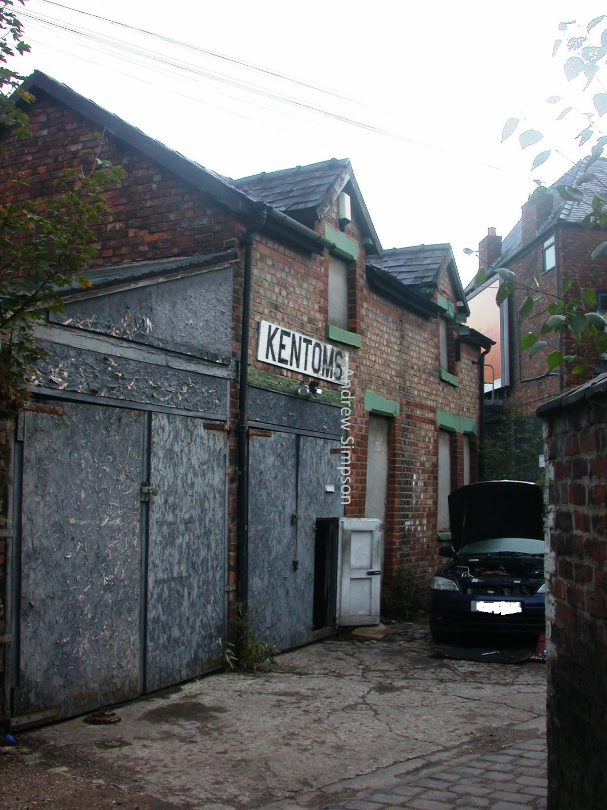
The garage in 2009
This is the workshop at the bottom of a ginnel off Siverwood Avenue, but is also visible from Barlow Moor Road.

From at least the  1960s it was a lock up garage, which when I took the picture was called Kentoms.

But there will be people who will remember the previous owners, perhaps right back to when it became a workshop.

In 2009 these were Ken and Tom, and Andy Holland has promised to tell me more about buildings from 1903.

Wandering back down to the site last week I noticed that it is being transformed, into what I don’t know.

I checked the Planning Portal but could only find a reference to the property dating back to 2009.

It looks to be one of remaining coach houses of which there are a few dotted around, but my problem is that there does not seem to be any large houses in the immediate vicinity which might have owned the building.

Clough Farm and Oak Bank, 1853
The nearest grand house was on the opposite side of the road roughly where Needham Avenue runs out into the Post Office car park.

This property was there by the early 19th century and has quite a history.  This was Oak Bank and was home in its time to the wealthy Morton family and later still the Cope’s who ran a chain of wine shops and drinking establishments in Manchester.

It stood in its own grounds which ran along Barlow Moor Road as far as Sandy Lane, and was bounded by what are now Zetland, Corkland and Wilbraham Roads.

By 1894 the estate had shrunk too little more than a pocket hemmed in by the houses on Corkland Road, Wilbraham Road and Maple Avenue and while its garden still extended west to Barlow Moor Road this too would be surrendered to housing by the beginning of the 20th century.

Ken & Tom's business, 2009
Today all that is left is a stone gate post with the name of the house and a bit of the old wall.

All of which means I gone looking elsewhere, and there is a candidate, although I suspect it was less a coach house and more a barn which was part of Clough Farm exactly where the present mystery building stands.

In 1845 this was the home and farm of Margaret Taylor who rented 10 acres of land which stood directly to the west of our building and down to Barlow Moor Road and High Lane.

She farmed a mix of arable, clover and meadow land and looking at the 1853 OS map, the footprint of the buildings includes part of a structure resembling the garage.

Being developed, 2018
Added to which the tithe schedule for 1845 records she occupied and paid rates and rents on “Home buildings, yard and garden”.

Now if that is the case our building is much older than I had thought.

Alas the present development looks to have retained only the shape of the old building.

The historic external brick work is missing but may be replaced, and its future use is unclear.

Next; Tyfords the Grocers, Andy Holland and heap more on that place.

Location; Chorlton


Pictures; map of Barlow Moor Lane, 1852, showing Clough Farm and Oak Bank, courtesy of Digital Archives, http://www.digitalarchives.co.uk/  and Kentoms Building 2009 & 2018, from the collection of Andrew Simpson


Thursday, 12 March 2015

Saving the home of Mr Sharpe on Beech Road

Well it is a place with plenty of history which I have feared would soon be gone.

133 Beech Road survived a serious fire which destroyed half its roof, and while a planning application had been in from 2011 nothing seemed to be happening.

The application was  “for conversion of single dwelling house to five self contained flats and refurbishment of shop unit (A1), involving a two storey rear extension and rear dormer windows.”

And now it appears that some work is being done and the word is that it will indeed become flats. 

Historically it is one of our oldest surviving houses, only beaten by the farm houses and Lime Bank.

It was home of Mr Daniel Sharp who lived there from certainly 1841 and maybe earlier.

He was a wine merchant and may have moved into the property with his new wife after their marriage in 1833.

Sadly she died in 1846 leaving him a widow until his own death in 1861.

Although that is not the full picture because in 1852 he married his servant Ann Bailey who was much younger than him. 

The marriage seemed not to be successful for nine years later she is no longer with him and in his will made shortly before he died having left her nothing he adds a codicil and awards her a small sum of money.  It is a story I will return to. 
The house has had a varied set of occupants since then gaining the jutty out bit at the end of the 19th century 

And even featured in a television series.

Now its conversion may seem an awful fate for the old house but I suspect better than its demolition which was what I feared.

This way we will retain something of what is one of the oldest residential buildings in Chorlton, only beaten by our surviving farmhouses and Lime Bank.

Mr Sharpe's house does appear on the blog** and in the book*** and I regularly correspond with one of his descendants.

Pictures; from the collection of Andrew Simpson 2013  and Tony Walker 1980

*Manchester City Council Planners, 131 Beech Road, Chorlton Manchester, http://www.publicaccess.manchester.gov.uk/associateddocs/MCCList1.aspx?095811/FU/2011/S1