Showing posts with label Ancoats. Show all posts

Monday, 15 June 2026

Pushing water up a hill …… looking for Mr. Mills in 1851

 Sometimes you know you are on a loser, but a mix of curiosity and a bit of stubbornness allied to the sheer fascination of digging deep into the past won’t allow you to stop.

John Broome and Jonathan Mills, 1828
And so it was with John Broome and Jonathan Mills who I first came across in a court case in 1828.

They were alleged to have taken part in a very nasty piece of vindictive bullying against a fellow apprentice in the Soho Iron Works in New Islington.

So far I haven’t been able to find out their fate at the Quarter Sessions only that they had both been ordered to find “sureties of £20 each to answer to any indictment at the sessions which having found, they were discharged”.*

Now £20 was a lot of money and there is no indication as to how they raised it.

But that was enough to set me off.

Not that I expected I would find out much.

After all we were dealing with two young men in 1828, who might not have lived long enough to make it into either the 1841 or 1851 census, and who any way could have moved away from Manchester or just slipped through the historical records.

Arthur Street, 1851

And it wasn’t a promising start because there wete plenty of John Broome’s in Manchester in the 1850s, but none quite fitted the profile.

Johnathan Miller was a tad different, because I found a Johnathan Miller on both the 1851 census in the Rate Books. This Mr. Mills gave his occupation as “Mechanic” and his age of 42 would have meant he was 19 in 1828, so just possibly still an apprentice.  
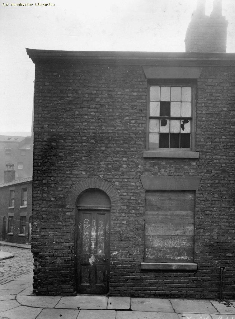
6 Arthur Street, 1901
He was living at 12 Arthur Street with his wife and three children in the heart of Ancoats, surrounded by textile mills engineering works and other industrial premises, all of which used machine power and in turn would have employed mechanics.

The family had been there from at least 1845 and were still there eight years later.  A decade later the family on Ashton New Road in Audenshaw and he described himself as a “labourer in a Chemical works”.  

I doubt we will ever now why he slipped down from a skilled job to being a labourer and while it is attractive to speculate it will not get us anywhere.

Of course this whole trail is based at present on two census returns and the assumption that this is our man, and that is a big assumption.

But the search did reveal a little bit about Arthur Street, which was bounded on two side by the River Medlock and on a third side by a railway viaduct and was located to the south of Fairfield Street closes to London Road Railway Station. 

It is now under the new development which is Mayfield. 

The family were paying a weekly rent of 3/8d and the maps of the period and a series of photographs taken around 1900 suggest that they were two up two down terraced properties.

Back of 6 Arthur Street, 1901
So a step up from the back to backs which many occupied but sufficiently close to the river and heavy industry to have offered little in the way of green verdant pastures.

And there the search for Jonathan Mills peters out,  reminding us that even if this is our man plenty of that water has flown back down the hill to make him and his family pretty obscure.

Location; Manchester in the mid 19th century


Pictures; extract from the Manchester Guardian, 1828, deatil of Adhead’s map of Manchester in 1851, courtesy of Digital Archives Association, http://digitalarchives.co.uk/, the site in 2023, courtesy of Goggle Maps, and 6 Arthur Street, m10771, Back of 6 Arthur Street, Bradburn A,m10771, Back of 6 Arthur Street, Bradburn A,m10772 courtesy of Manchester Libraries, Information and Archives, Manchester City Council, http://images.manchester.gov.uk/index.php?session=pass

Arthur Street, now part of the Mayfield development, 2023

*Manchester Guardian, July 5th 1828

Sunday, 17 May 2026

The lives behind the doors ….. numbers 2-14 St Andrew’s Square

Now, it has become quite popular to take a house and tell its story over time.

St Andrew's Square, 1849
Long before a certain television series did just that with a property in Liverpool, I had done the same for our house in Chorlton, along with the two I grew up in, in south east London, and the home of our Josh and Polly who live in Leicester.

And over the years I have dipped into the history of heaps of houses, including Homer Street and Coronation Square, both of which were in Ancoats and which were developed in the late 1830s.

Back then the area was just beginning to change from what one account described as a place “of fields [where] the waters of the River Medlock which are close by ran pure and sweet and were the home of beautiful trout.” *

Within a generation the fields had been covered with mills, factories, foundries and dye works along with mean terraced housing and the Medlock began its long association with filth and pollution.

The area, 1819

And so to the challenge laid down by Bob and Del Amato to find out about what was there on the site of what is now their business. **

The warehouse of Amato Food Products stands on what was once a row of fourteen terraced houses which faced St Andrew’s Church. 

I can’t be exactly sure when the square was developed, but the church was opened in 1831 but by 1839 the properties show up in the rate books.

Eighteen years earlier according to Johnson’s map of 1819 the area up from the river to the canal was still open land although already it was edged with buildings.

St Andrew's Square, no 2 at the bottom, 2021

But the 14 properties along the southern side of the square were a cut above their neighbours .

The houses consisted of five rooms and they commanded a weekly rent of just over 5 shillings, which is higher than the surrounding streets.

And many of the residents were drawn from the skilled working class, including a railway clerk, a tailor, a dressmaker and a bookkeeper, along with a salesmen, painter and book keeper.

Their origins were as varied as their occupations with a fair few having come from Scotland, Yorkshire and the Lakes, with others from Cheshire as well as Salford.

I could have picked any of the 14 homes but ended choosing no. 2 St Andrew’s Square for no other reason than it was the first in the row as entered the square from St Andrew’s Street.

Today it is the western end of the Amato warehouse, but in 1851 it was home to Mr. and Mrs. Cruickshank, and their five children, Elizabeth, May, Emma William and James.

Mr. Cruickshank was 43 years old, had been born in Manchester and gave his occupation as a Miller.  His wife Hannah was three years younger and was from Salford.  Three of the children were born in Chorlton on Medlock and the youngest in Oldham, and despite the fact that they ranged in age from 20 down to 13, only William who 15 is listed as working.

Looking east along the square, 2021

I doubt that any of them had attended the school at the other end of the square but certainly some of the children from the other houses will have done.  

The school appeared in an earlier blog story but deserves to be revisited.***

What is interesting is that the square does not appear in the street directories until the beginning of this century, by which time our house was occupied by Samuel Boole who was a labourer for Manchester Corporation, his wife Ethel, their five children and Ethel’s mother.  

Like many families of the period, they appear to have moved across the city, and we can track their movement by where their children were born. The eldest of the children was born in Chorlton-on Medlock and the rest in Ancoats.

In time I shall dig deeper into the stories of both the Boole family and the Cruickshank’s, as well  the occupants of the other thirteen houses.

Inside the warehouse, 2021

All of which just leaves me to ponder on what remains may lie below the warehouse.

Location; Ancoats

Pictures; St Andrew’s Square, 2021, courtesy of Angela Wallwork, and St Andrew’s Square in 1849, OS map of Manchester and Salford, 1844-49,  and the area in 1919 from Johnson's map, courtesy of Digital Archives Association, http://digitalarchives.co.uk/

*Commemorative Booklet, St Andrews Church Ancoats, 1831-1931

** Amato Products Ltd, https://amatoproducts.co.uk/

***Looking for the lost ...... one street over time in Ancoats ..... no 4 the school by Homer Street https://chorltonhistory.blogspot.com/2020/07/looking-for-lost-one-street-over-time_7.html


Saturday, 16 May 2026

Looking for the lost ...... one street over time in Ancoats ..... no 5 “debris and desolation”

The story of one street in Ancoats, and the people who lived and worked there.*

Ancoats residents, 1920
Now I am a little closer to being able to date the end of Homer Street.

It went in the big slum clearance push in the 1930s when a large chunk of the area around St Andrew’s Church in Ancoats went in matter of a few years.

Homer Street dated from 1837 and so just missed its hundredth birthday

And while some may have mourned its passing I doubt that there were many.

According to the Corporation there were 1,045 properties in the area around St Andrew’s Church of which “990 were occupied dwellings and 47 business premises leaving eight properties either derelict or unoccupied.”**

They were in the words of the Manchester Medical Officer of Health both unfit and “dangerous or injurious to health [and in his opinion were] a clearance area.”

Homer Street, 1894
He added that “in general the dwelling houses were of a similar type throughout the area, all fronting directly on to the streets, which generally speaking were somewhat narrow.  

These were conditions one generally found in the area of this type of small houses; narrow passages and high back yard walls. 

Of the houses 872 fronted into streets 39 feet or less in width, 469 on to streets of 24 feet or less.  The yards in the majority of cases were small and the property in the majority of cases was old.

There were 154 houses over 100 years old, 109 over 90, and 723 over 60 years old.  The density was 79 houses to the acre on net area and 52 to the acre on the gross area.”

Now like many I lived in a small two up two down terraced house in the 1970s and such properties can still be found across the country are still doing the business of keeping people warm, and comfortable and will still have a long life ahead of them.

But these were built at the end of the 19th century and by and large had been well maintained.

Those like the one my grandparents occupied in Hope Street, dated back to the beginning of the 19th century and were past their sell by date by the 1930s, but lingered on into the 60s.

Not so Homer Street or it neighbours, Andrew’s Square, Gees Place, Dryden Street and Marsden Square, all of which had all gone by 1938. The Corporation judged that many were worth less than £50 and “719 in the area were verminous.”

Of course there were objections, ranging from the landlords of some of the properties to those who thought that the replacement homes in Smedley were not suitable, leading one witness to at the inquiry on the clearance plans to describe them as “barracks” adding it was not acceptable to “make the British workman, after he has done his work climb six flights of stairs.”

Back of the demolished school, 1966
Some also questioned the policy of not rebuilding new homes in the area, pointing out that for some the cost of travelling from the new estates in places like Wythenshawe was very expensive.

But the Corporation “had zoned the whole of the area for light industrial purposes” and this was pretty much how it turned out.

The old school on the corner of Homer Street which had been opened in 1836 went, and the site became a sheet metal works while the rest of Homer Street was left as open land finally becoming a bus depot in the 1960s.

That industrial development was slow to come and in the August of 1939 the Reverend A. R. Denn of St Andrew’s wrote to the Manchester Guardian that the cleared area as “a scene of debris and desolation” with “the remains of houses in various stages of demolition.  Some buildings remain standing with broken windows and derelict doors.  

All around one may see the foundations of houses and the remains of door steps and yards, brick bats and odd pieces of stone are strewn about on all sides, whist here and there nature tries to cover up this hideousness with weary looking grass.”***

Adding that it “reminds one of the pictures of Flanders during the last war, and resembles nothing so much as the after-effects of an air raid.”

And while his observations may well have been accurate and echoed many who felt “it was not a square deal for those who have to live and work amid it”, it is worth pausing to reflect on what the Corporation was trying to do.

According to Alderman Jackson that was nothing less than a programme “to tackle about 30,000 houses in Manchester” at a time when the City was still recovering in many ways from the Depression.

There is nothing now to see of Homer Street.

For a while the plan of the streets continues to appear on maps but by 1960 even these have gone.

But nature and commerce abhor a vacuum and the site had undergone new development with the empty and derelict bus depot replaced by a large modern food warehouse.

Location; Ancoats

Pictures; Mothers' Outing, St Andrew’s Church,1920,  m70137, and Sheffield Street back of St Andrew's Church,  Revill and Son Ltd, 1966 Brooks T, m12041 courtesy of Manchester Libraries, Information and Archives, Manchester City Council, http://images.manchester.gov.uk/index.php?session=pass and Homer Street, 1894, from the OS South Lancashire, 1894, courtesy of Digital Archives Association, http://digitalarchives.co.uk/

*Homer Street, https://chorltonhistory.blogspot.co.uk/search/label/Homer%20Street

**Ancoats Clearance Order, Manchester Guardian, September 26, 1934

***Debris and Desolation, A.R. Denn, letter to the Manchester Guardian, August 4, 1939

****Amato Food Products, http://www.amatoproducts.co.uk/

Friday, 15 May 2026

Looking for the lost ...... one street over time in Ancoats ..... no 4 the school by Homer Street

The story of one street in Ancoats, and the people who lived and worked there.*

Homer Street was located just south of St Andrew’s Church and was bordered by the canal to the north, the river to the south and London Road Railway Station to the west.

The houses date from 1837 and just six years after the church was built.

Back in 1831 St Andrew's  Church was in “the midst of fields [when] the waters of the River Medlock which are  close by ran pure and sweet and were the home of beautiful trout.” **

At the time “the congregation of St Andrew’s was in its early years a fairly comfortable middle-class body, [with] most of the pews in the church being privately rented by people of substance. But by the middle of the century it was surrounded by rising Lancashire industry and black slums filled the parish.***

Five years later the church opened a Sunday school on the corner of Homer Street and Arundel Street which in 1846 became a day school.

The school records show that teaching there was to use that modern description “challenging.”

In 1850 there was an average attendance at the day school of about 200 and four of five hundred boys and girls attended irregularly at the Sunday school.

And in 1866 the authorities went looking for forty boys who were absent one morning  concluding  that “the parents are sadly to blame for keeping their children at home” and on another occasion observed that “130 present at a time and the teacher ill, make it rather hard work to keep things straight.”

Given all of that I can sympathise with the comment made in 1864 that the school master was “glad that the week has closed so that one might have a little rest.”

But even by the 1860s the population of St Andrew’s parish was in decline and in 1891 the school reported that "the number of children on the books was gradually diminishing owing to properties being condemned as uninhabitable", although the final clearances  only got  underway in the late 1930s.

So that by 1936 the population had fallen from 16,000 a century earlier about to 3,000 with many families having been moved out to Gorton and Clayton.

That said the school still had about 230 students on roll and their attendance was very good winning them the Entwistle Memorial Shield for the best school attendance in the city’s elementary schools which seems a nice positive point to close on.

The site is now part of the warehouse of Amato Food Products.****

Location; Ancoats

Pictures; St Andrew’s School, Homer Street, 1920, m48646, courtesy of Manchester Libraries, Information and Archives, Manchester City Council, http://images.manchester.gov.uk/index.php?session=pass

*Homer Street

**Commemorative Booklet, St Andrews Church Ancoats, 1831-1931

***A Centenary in Ancoats, St Andrew’s School, Manchester Guardian, June 13 1936


Thursday, 14 May 2026

Looking for the lost ...... one street over time in Ancoats ..... no 3 Homer Street when the developer came knocking

The story of one street in Ancoats, and the people who lived and worked there.

North of the river, 1819
Homer Street was located just south of St Andrew’s Church and was bordered by the canal to the north, the river to the south and London Road Railway Station to the west.

A short walk in pretty much any direction would offer a mix of cotton mills, dye works and timber yards all of which provided work for the residents of our street.

I can’t be exactly sure when it was built, but St Andrews which is just one street away was opened in 1831 and by 1837 the properties show up in the rate books owned by a Mr Price.

And just eighteen years earlier on Johnson’s map of 1819 the area up from the river to the canal was still open land although already it was edged with buildings.

The area, 1966
Homer Street seems a cut above some of the others.

The houses consisted of four rooms and they commanded a rent of 1 shilling and 9d a week.

This was at a time when the best wages paid in the cotton factories in 1833, for a man in his 30s might earn 22 shillings and 8d.

Sometime between 1934 and 1988 the properties were demolished and the site is given over to a sheet metal works which continued to occupy the site until the 1960s when for a while the land was vacant.

During the 1970s and until quite recently the area was a bus depot which ceased operating at the beginning of this century.

It is now a food warehouse owned by Amato Food Products.*

It would be intriguing to know if anything the Homer Street properties still exist just below the surface.

Not that I would ask Mr Amato to dig a hole in his warehouse floor.

Location; Ancoats

Pictures; a section of Ancoats whre Homer Street was to be built in 18i6, from the Johnson’s map of Manchester, 1819 courtesy of Digital Archives Association, http://digitalarchives.co.uk/ and  St Andrew’s Square from St Andrews Street, facing west, 1966, T Brooks, m10604, courtesy of Manchester Libraries, Information and Archives, Manchester City Council, http://images.manchester.gov.uk/index.php?session=pass

Wednesday, 13 May 2026

Looking for the lost ...... one street over time in Ancoats ..... no 2 Homer Street and the Ward family

Now I would like to think that one of these young people could be Ethel Ward.


Students at St Andrews School, 1920
She was living with her parents at number 9 Homer Street and it is just possible she attended St Andrew’s School which was at the end of the road.

Homer Street and in particular number 9 has over the last few days drawn me in and I want to know more.

It was just a few minutes away from Fairfield Street and on a quiet night the Ward family would have heard the distinctive clunk of railway waggons being shunted in the nearby sidings, caught the smell from the river and the dye works and worried that young Ethel might do something daft beside the canal.

Homer Street, 1894
That said I remember my old friend Norman who had been born close by telling me how he had learnt to swim by being thrown in that same canal.

I last visited number 9 in 1851 when it was home to two families.

At that time I knew little about the property but now know that it consisted of four rooms which given that there were seven of them must have made it a squeeze.

Just exactly what the condition of number 9 was like is unknown, but by 1911 it was at least 74 years old having been built as part of the swift development of the area in the early and mid 19th century.*

The class of 1920, St Andrew's School, 1920
The earliest entry in the rate books is 1837 when the block was owned by a Mr Price who is still the owner in 1851.**.

I suspect Mr and Mrs Ward counted themselves relatively lucky because many of the surrounding properties consisted of just two and three rooms and were home to large families.

He was an electrician for Manchester Corporation and as such was a skilled worker.

They had been married for eleven years and Ethel as their only child.

For Ethel there would have been little that could be said to have offered up exciting places to play.

Just a short walk down Phobe Street was a tree lined Recreational Ground which backed on to the river but it was dominated by a cotton mill off to the east and the Ancoats Goods Yard to the north delivering a fair share of noise, smells and if the wind were in the wrong direction no doubt the old cloud of smoke.

Of course there is a danger in letting your imagination over play the industrial scene and I have also to concede that by the time our school picture was taken Ethel would have been fourteen and already working, perhaps in that very textile factory that overlooked the Rec.

St Andrew's Square, 1966
Her home and the rest of the houses on Homer Street had gone by 1938 although the street and some of the surrounding ones continued to appear on maps, but by the end of the century even their imprint had vanished under a site which had various industrial uses and now is a warehouse for Armato Food Products  and it was the current owners who suggested I might be interested in the site.***

Which is almost the end, but I have to add that in wandering the neighbouring streets I did come across a Mr Simpson living with his wife and two boarders in three rooms at number 17 St Andrew’s Street.  He was no relation but I like the way a random search throws up a Simpson.****

Pictures; St Andrew’s School, Homer Street, 1920, m48646, and St Andrew’s Square from St Andrews Street, facing west, 1966, T Brooks, m10604, courtesy of Manchester Libraries, Information and Archives, Manchester City Council, http://images.manchester.gov.uk/index.php?session=pass and Homer Street in 1894, from the OS for South Lancashire, 1894 courtesy of Digital Archives Association, http://digitalarchives.co.uk/

*Homer Street, Enu 12 272, Central, Manchester, 1911

**Manchester Rate Books, 1837- 1851

***Amato Food Products, http://www.amatoproducts.co.uk/

****St Andrews Street, Enu 12 188, Central, Manchester, 1911

Tuesday, 12 May 2026

Looking for the lost ...... one street over time in Ancoats ..... no 1 Homer Street

You won’t find Homer Street.

St Andrew's School, 1910
It disappeared sometime between 1934 and 1938 and I guess was part of an early clearance policy.

There will be ways of finding out but for now I am going to concentrate on the 100 or so years it was there when it was home to generations of families who worked in the factories the mills, and the timber and railway yards.

The project was prompted by my friend Bob Armato who commissioned a report on the area in advance of building a warehouse on the site.  By then Homer Street and the neighbouring properties on St Andrew’s Square, Gees Place, Dryden Street and Marsden Square had vanished so completely that they do not appear on any modern maps.*

Homer Street, 1851
But go back into the middle of the 19th century and they are all there.

It is difficult at present to get a sense of what the houses were like, but some at least were back to backs that looked out on to narrow and half enclosed streets and courts.

At the end of Homer Street was a reservoir and three streets down was the Mount Street Dye Works.

Sometime around 1851 the St Andrew’s National School was opened.  It is there on Adshead’s map of that year but is missing from the OS for 1849.

In time I will explore its story but so far I know that in 1911 the boys school had 248 students on roll although the average attendance was just 155, while the girls school had 272 with an average attendance of 160.

St Andrew Street, 1850
Some at least of the students would have been drawn from Homer Street.**

In 1851 it consisted of 15 houses which were home to 93 people.

The occupations of the residents included a porter, charwoman, several labourers, a carter and a number who did various jobs in the textile industry.

Most were from Manchester or the surrounding townships but a fair few as you would expect from the date were from Ireland.

At number 9 was Mr John McCormick a stone mason from Ireland living with his wife Mary who had been born in Manchester and their son James.  The house was also occupied by the five members of the Harris family.  Mr Harris and his wife were also from Ireland although their children were born here.

St Andrew's Church. 1960
There is much more and over the next few weeks I shall wander back to the beginning of Homer Street and forward into the 1930s in an effort to record some of the changes to the area and how the families of Homer Street fared.

But I shall conclude by observing that for almost all of its existence it didn't even get an entry in the street directories leaving me to fall back on St Andrew Street's listing for 1850***

Location; Ancoats


Pictures; St Andrew’s School, Homer Street, 1920, m48646, and St Andrew’s Church, 1964, T Brooks, m10604, courtesy of Manchester Libraries, Information and Archives, Manchester City Council, http://images.manchester.gov.uk/index.php?session=pass and Homer Street in 1851, from Adshead map of Manchester 1851, courtesy of Digital Archives Association, http://digitalarchives.co.uk/

*Amato Food Products, http://www.amatoproducts.co.uk/

**Homer Street, Enu 1u 2-6, London Road, Manchester, 1851

***Slater's Directory of Manchester & Salford, 1850, page 90

Friday, 19 September 2025

Doing the Ancoats Trail …….. 39 years on … part two

Now, something like 39 years ago I did the Ancoats Trail, which had been designed by Jaqueline Roberts as a guide to what were left of our late 18th and early 19th century buildings.


So, armed with the trail I shall be off on a day when the rain is not falling like stair rods and complete part one of the trip back into the city’s past.

Watch this space.

Location; Ancoats

Pictures pages from the Ancoats Trail, 1984


*The Ancoats Trail, Jaqueline Roberts, Education Service, Greater Manchester Museum of Science and Industry

Thursday, 18 September 2025

Doing the Ancoats Trail …….. 39 years on ...... part one

Now, something like 39 years ago I did the Ancoats Trail, which had been designed by Jaqueline Roberts as a guide to what were left of our late 18th and early 19th century buildings.

The Ancoats Trail, 1984
In 1815 Ancoats had more cotton mills and the largest number of households than any of the other rating districts in the city.

The population, swelled by large numbers of immigrants from Ireland as well as the surrounding area, rose from 11,039 in 1801 to 53,737 by 1861.

It was a crowded and teeming place, which visitors to Manchester either admired or like the Prussian, Johann Georg May thought was a “scene of melancholy.”

A view endorsed by another foreign visitor, who “saw the forest of chimneys pouring forth volumes of steam and smoke, forming an inky canopy which seemed to embrace and involve the whole place ......It is essentially a place of business, where pleasure is unknown as a pursuit, and scarcely rank as secondary considerations. 

The Bradley Street three, 1983
Every person who passes you in the street has the look of thought and the step of haste”

Richard Buxton who lived amongst the grime, smoke and melancholy was far more generous when he wrote, “The operative who lives in a large manufacturing town, sees plenty of the handyworks of his fellow-men in the giant steam-engine, the ingenious mule, which rivals the gossamer in spinning threads, the never-tiring power loom, and the countless other contrivances of mechanical skill which have resulted from the fertile brain of man.”

But this paean to industrial Manchester only serves to act as a contrast to the wonders of flowering plants and open fields. The worker might see “the triumphs of science and art but little of the works of nature. This renders him an intelligent, but to a certain extent, an artificial man.”

Bradley Street, 2016
It is no wonder I suppose that he should hold to the “many delightful walks, by pleasant streams through green woods.” All the more so when faced not only with the dirty industrial waterways, and satanic mills but awful hovels which were home to so many in Ancoats.

Speculators had followed the industrialist in laying out streets and building houses in the area and with no regulations much of the housing was of the worst type.

So here, are the first seven which featured in the publication.  Some like the three one up one down cottages on Bradley Street, survived after decades of neglect and were converted into offices.

They are the last remaining one up one down houses in Manchester. And were redeveloped in the late 90s and nothing is left of the original interior.

The Trail, part 1

Similar houses which have been excavated at Greengate in Salford opposite St Mary’s in Manchester reveal the small shoddy nature of this type of house.

They had room sizes of less than 3.5 m square with foundations of one brick depth.

Walking the Trail
Each ground floor room had a fireplace but there was no sign of floor covering nor a staircase and it is likely that access to the upper floor was by a wooden ladder.

Others on the list were grander, like the row on Lever Street, which have also survived.

They were built in the 1790s and were constructed on three floors with cellars and were occupied by artisan families. The uppermost floor would have been used as workshops and some of these surviving on Liverpool Road still have the longer and wider windows designed to admit the maximum amount of daylight.

So, armed with the trail I shall be off on a day when the rain is not falling like stair rods and complete part one of the trip back into the city’s past.

Watch this space.

Location; Ancoats

Pictures;  one up one down cottages in Bradley Street, 1983 from the Early Manchester Dwellings Group Bradley Street, 2016 from the collection of Andrew Simpson, and pages from the Ancoats Trail, 1984


*The Ancoats Trail, Jaqueline Roberts, Education Service, Greater Manchester Museum of Science and Industry

References
Hartwell Clare, Manchester2001 Penguin page273
May Johann Georg, quoted in Visitors to Manchester complied by L D Bradshw Neil Richardson Manchester 1987 page 25
Cooke Taylor William, Notes of a Tour in the Manufacturing Districts of Lancashire quoted in Visitors to Manchester page 36
Buxton R A page xii
Nevell Michael, Manchester the Hidden History The History Press page 149

Wednesday, 17 September 2025

The hatter, the policeman’s wife and a nice line in tapenade, and fresh pasta …….. stories from St Andrew’s Square

I doubt I would ever have explored St Andrew’s Square if I hadn’t taken up the invitation of Bob and Del Amato to visit their food warehouse.

St Andrews Square, 1851

I knew the square and had wandered past it but had never stopped even to stare at what had become a car park and a home for light industry.

The square is one of those little bits of half forgotten Ancoats, which long ago lost its residents, it’s church, and its school.

The residents began to go in the clearance programmes of the 1930s, the school followed sometime later, and by the end of the following decade the church stood alone, until it closed in 1958.

A few years ago I did some work on Homer Street which backed on to St Andrew’s Square and had fully intended to widen my research but never did.*

And so today I have decided to rectify that  omission.  

The square is actually just an L shape which takes up the south and east side of the site of St Andrew’s Church.

I can’t be exactly sure when the square was developed, but the church was opened in 1831 and by 1839 the properties show up in the rate books.

St Andrew's Church, 1964

And just eighteen years earlier on Johnson’s map of 1819 the area up from the river to the canal was still open land although already it was edged with buildings.

St Andrew’s Square, along with Homer Street seems a cut above some of the other streets.

The houses consisted of five rooms and they commanded a weekly rent of just over 5 shillings, which is higher than the surrounding streets.

And many of the residents were drawn from the skilled working class, including a railway clerk, a tailor, a dressmaker and a bookkeeper, along with a salesmen, painter and book keeper.

Their origins were as varied as their occupations with a fair few having come from Scotland, Yorkshire and the Lakes, with others from Cheshire as well as Salford.

So I know that Margaret Mills at number 16 St Andrew’s Square, who was married to a police constable, came from Scotland, and shared her home with seven others, including a nephew, a niece, her father, sister in law and two lodgers.

And not to be out down, her neighbour, Mr. Maddoy the hatter, shared his house with his wife his sister inlaw and her three children, all of whom were engaged in the hat industry.

The plan will be to follow the square’s fortunes over the next century and a bit, charting the different families who lived there, the changing use of the land, and the changes over the last few years.

St Andrew's Square

Which leads me back to Amato Foods, because their site was for a while a sheet metal works, before it became site was used as a vehicle repair centre by the post office, and now a food warehouse.

And I am indebted to Bob and Del for sharing the survey that was undertaken on their site and which offered up some  interesting insights to the the previous occupants.

But more about them, along with the story of the church and the school another time, leaving me just to mention the wonderful tapenade and fresh pasta which Amato Foods make in the premises, along with their delivery service offering a range foods that can be delivered to the door, but I wont because that would be advertising, so I shall just direct you to the links.**

Location; St Andrew’s Square, 

Pictures; St Andrew’s Square  in 1851, from Adshead map of Manchester 1851, courtesy of Digital Archives Association, http://digitalarchives.co.uk/, St Andrew’s Square, 2021, courtesy of Amato Food Products, and St Andrew’s Church, 1964, T Brooks, m10604, courtesy of Manchester Libraries, Information and Archives, Manchester City Council, http://images.manchester.gov.uk/index.php?session=pass

*Homer Street; https://chorltonhistory.blogspot.com/search/label/Homer%20Street

** Amato Products Ltd, https://amatoproducts.co.uk/ and to order, info@amatoproducts.co.uk

Sunday, 24 August 2025

Those who went from Ancoats to serve in the Italian army in the Great War

Manchester Guardian, 1919
“Italians seem to be re-establishing themselves in Ancoats as fast as the military authorities will allow.”*

Now I have long been fascinated by Little Italy and the contribution made to the life of the city by the Italians who settled there in the late 19th century.**

And as you do just naively assumed that when the Great War broke out in 1914 some at least would enlist.

Now at present I have no way of knowing who and how many did but the real story comes in to its own eight months later when Italy joined the war on the side of the Allies.

Even then I just assumed they would join up locally, but being Italian nationals they chose to return to Italy.

To Our Italian Comrades, 1915-1918, Manchester, 2014
The Manchester Courier reported in August 1915 that 70 young men had already left and went on to reveal that many older men were also planning to leave.

As always behind such decisions are a wealth of stories like those men who made the long journey only to be found medically unfit.

Or the  “young Italian medical man resident in Manchester [who had] the misfortune to be born in Berlin was at the outbreak of the war placed in a concentration camp by the English authorities [and] while anxious to join his colours to fight the Germans had to fraternize with the enemy prisoners [until] he could return to Italy only to find his eyesight debarred his entering the army and so was on his way back to England.”***

And behind that decision to leave for home came the equally difficult choice of uprooting the whole family and taking them back as well. As the Manchester Guardian observed “many of the poorer men will be careful to take their families with them, so that the Italian Government my provide for their maintenance if the need should arrive.”****

But once the war was over “men have been coming back-in some cases whole families have come back-to Ancoats, mainly, it may be under the pressure of economic considerations, but not-without a certain pleasure  in the return.” 

The reporter might have also added that for some at least the decision to serve in the Italian army had been at considerable economic sacrifice.

One such case highlighted by the Manchester Courier in 1915, involved a successful Italian ice cream vendor who sold his business and furniture leaving his wife to find work in a local firm to support their children.

Outside Nazaren Bela's Ice Cream shop, Jersey Street, 1922
Of course many of the stories that appeared in the papers during 1915 were in part designed to bolster the mood for war which had gone off the boil in the eight months since the start of the conflict.

And much had been made of the spontaneous demonstrations by “a considerable number of Italian subjects living in Manchester and Salford for the war” including a “procession through the main streets of the city to the Town Hall” just days after Italy joined the war.

It was estimated that 300 men might eventually leave for Italy and given that there were about 1000 Italians in the twin cities with upwards of 500 in Ancoats this was a major contribution to the war.

All of which puts into context that newspaper story of the return of so many to Ancoats.

Pictures; The Manchester Guardian, September 6 1919, Memorial “To our Italian comrades, from the collection of Sally Dervan, 2014, and outside Nazaren Bella’s Ice Cream Shop on Jersey Street, 1922, courtesy of Manchester Libraries, Information and Archives, Manchester City Council, http://images.manchester.gov.uk/index.php?session=pass

*Italy in Ancoats, the Colony coming back after the war, Manchester Guardian, September 6 1919

**Little Italy, http://chorltonhistory.blogspot.co.uk/search/label/Little%20Italy

***Manchester Courier, August 1915

****The Italian Colony, Excitement in Ancoats, Manchester Guardian, May 26 1915

Wednesday, 20 August 2025

The Prince’s of Loom Street ……. lost streets of Manchester no. 97

History has not been kind to Loom Street in Ancoats or for that matter Naval Street, Cotton Street and Elizabeth Street.

Cotton Street, 2023
These were the narrow streets you would have encountered in the space between Oldham Road to the north and Great Ancoats Street to the west.

Loom Street never featured in any of the early street directories and now parts of it have been relegated to a car park while its eastern section is underneath a modern set of industrial units.

And when it did appear in the 1911 directory, the only entry is for one firm at no. 8 which was “Wansker, David, trimming manufacturers” .

All of this despite the fact that in the mid-19th century it consisted of 116 houses, many of which were small back-to-back cottages and the street let out in to 14 closed courts of various sizes.

But then I am not surprised given that a section of Blossom Street which ran parallel was renamed Naval Street, and nearby Elizabeth Street has vanished under a non-descript brick slab.

Back in the 1970s Loom Street came to the attention of the Manchester Historical Association who produced a pack of original source material about the street and focusing on one family.  

The pack was designed to be used in the classroom introducing school students to the skill of interrogating documents and using them to build a picture of life in a working class part of the city during the middle decades of the 19th century.

Loom Street and Murray's Court, 1851
I long ago lost or gave away my copy and as yet I haven’t been able to track down a replacement.  But given that the family were called Prince and they lived in Loom Street in the middle decades of the 19th century, I followed the creators of the pack and went looking for them in the census records and there they were living at no. 9 in 1851.  The Rate Books show that they occupied the house from a decade earlier and were still there in 1857.

They paid a weekly rent of 3 shillings and six pence to the estate of the Earl of Elsmere who had who had an extensive portfolio of properties in Loom Street and the surrounding streets.

I can’t be sure exactly where their house was on Loom Street but I rather think it will have been on the northern side close Cotton Street.  The houses were demolished when St Chad's School on George Leigh Street was extended south and St Michael’s Roman Catholic Church was built next door sometime around 1867. 

Loom Street and St Mary's Court, 1849

And that extension with the construction of the church resulted in the demolition of numbers 1 -9 along with a small, closed court known as Murray’s Court which only a few years earlier had been known as St Mary's Square.

All a tad confusing.  On one level I doubt the loss of these houses caused much of a stir given that some including the home of the Prince’s were small two roomed back to backs.

Murray’s Court consisted of 8 back to backs and access was through narrow passages leading off Loom and George Leigh Streets, presenting us with a location where the sun fought to penetrate the open space, and fresh air struggled against the various smells of close living.

Loom Street and St Michael's RC Church, 1894
The upside of the renovation of the buildings that replaced numbers 1-9 and Murray’s Court in 2016 has been the careful restoration of a wall memorial stone dedicated to the memory of “The Very Rev Thomas Cannon Byrne Rector 1878-1907”, which in time will offer up more research possibilities.

But alas the historical records are less forthcoming about the Prince family after 1857 and to date have offered up no details of the inhabitants of Murray’s Court.

In time something will pop up but not yet. Thomas and Hannah Prince were married in 1830 and both signed their names rather than making a mark. He gave his occupation as a spinner, and two of their five children were also engaged in the textile trade as piecers.

And had you wandered along the street in the 1850s, the majority of those who you might have met were in occupations related to the manufacturer of textiles, while others were labourers or engaged in skilled trades, like dress and makers, some bricklayers and even a Policeman.

Trying for posterity, Naval Street, 2023

Most were born in Manchester or from the surrounding towns with a few from Yorkshire and Ireland.

And few have been remembered by history, if history ever bothered to acknowledge them at all.

Leaving me just to reflect that some of the present occupants of the area have tried to leave their mark on at least one of the forgotten streets.

Location; Ancoats

Pictures; Naval Street, and Cotton Street, 2023, from the collection of Andrew Simpson, and Loom Street in 1849 from the OS map of Manchester & Salford, 1849, in  1851, from  Adhead’s map of Manchester, 1851, and in 1894 from the OS map of South Lancashire, 1894, courtesy of Digital Archives Association, http://digitalarchives.co.uk/


Tuesday, 19 August 2025

Collecting for the Ancoats Hospital in the summer of 1924

I belong to that generation which was the first to grow up with the National Health Service.

School Daisy Day, date unknown
It over saw my birth in the General Lying In Hospital in Lambeth went on to look after me through the succeeding decades and is all the more a friend as I pass into my 66th year.

And for most of what I have needed it has continued to be free at the point of need offering the best medical care I could ask for.

But of course had I been born just a decade earlier my parents would have been expected to pay for my care not through their taxes but directly out of their pocket and like many would no doubt have been forced to dig deep from the family income.

All of which is a powerful reminder that there was a time when medical care was neither automatic nor a certainty for a large section of the population and that funding for our hospitals was still reliant on charity and big annual events.

Ancoats fancy dress day, date unknown
These ranged from The Alexandra Flag Days to local events and all were geared to raising cash which brings me back to a series of postcards from the collection of David Harrop and The Daisy Day Parade.

This was a regular event which began in June 1913 to raise money for Ancoats Hospital and consisted of selling artificial daisies and a fancy dress parade.*

All of which brings me back to the post cards.

An invitation, July 1924
Now I have no idea when the photograph was taken which means it could date from the 1920s and perhaps even from the events planned at the General Meeting held on July 17th to which Miss Miriam Buckley of 18 Dawns Street was invited.

It was held in the Out-Patients Department of the hospital and was the General Meeting for the Ancoats Daisy Day’s Hospital.

In time I might be able to track down the minutes and discover if she attended.

There is a reference to a Miriam Buckley aged 10 living with her parents at 59 Herbert Street, Ardwick in 1911 but after that the trail goes cold save for a  reference to her death in 1974.

The Manchester Guardian reports, July 21 1924
Either way I think she would have pleased with the events of the day which the Manchester Guardian reported “took the form of a fancy dress parade on the lines of the student’s procession on Shrove Tuesday.

In this case, however the industrial areas rather than the business centre of the city were tapped by the collecting boxes.  

The better to cover as large an area as possible the parade divided forces, one party going through Ancoats and by way of Ashton Old and New Roads to Belle Vue Gardens, the other combining Chorlton-on Medlock, Hulme, and Ardwick.


Fancy Dree, 1924
Numerous prizes were awarded for figures in the processions and there were prizes for those who collected the largest amounts.”**

I doubt that I will ever be able to confirm a date fo those young people in their Daisy Day fancy dress, but if I were to slip into speculation and fastened on July 1924, then some of those staring back at me may well have become proud parents in an NHS hospital in the years after its creation in 1948.

Now that would round the story off nicely.

Pictures; School Daisy Day, date unknown and invitation to Miss Miram Buckley, July 14 1924 from the collection of David Harrop, and Manchester Guardian, 1924, courtesy of Manchester Libraries, Information and Archives, Manchester City Council, http://images.manchester.gov.uk/index.php?session=pass

* A Daisy for Daisy Day, A History of Ancoats Dispensary in 100 Objects, https://ancoatsdispensary100.wordpress.com/2015/02/13/17-a-daisy-for-daisy-day/

**Fancy Dress Parade for the Hospitals, Manchester Guardian, July 21 1924