Showing posts with label Spinningfields. Show all posts

Saturday, 30 May 2026

Sidney Street …… little valued …….and now forgotten

This is Sidney Street or what is left of it.

Sidney Street, 2025

Once upon a time it ran off Hardman Street, taking a sharp right and becoming Thompson Street before joining Joddrel Street.

Sidney Street, 1974
Later Thompson Street was renamed Tivoli Street and just a decade ago you could still trace the route from Sidney Street following the old street plan.I did it regularly but by then it was pretty much all open land with just the road surface and a remnant of a building to bear witness that this had been a busy place.

I say busy but you would have to go back to the 1850s to find much stirring on Thompson Street which consisted of sixteen back to back houses on the northern side facing nine larger properties which backed on to Ashely’s Silk Mill, Hampson’s Hat Factory and Thompson’s Chemical Works.

Those railings, Sidney Street, 2025

A century later these had all vanished under large warehouses, which in turn were demolished to make way for a car park and a grassed verge.

Sidney Street, 1851

And now they in turn have gone and the site is occupied by a large 21st century building.

Sidney Street, and Thompson/Tivoli Street, 2012
But compare the image of Sidney Street today with that of 1974 and tiny vestiges of it most recent past is there from the iron railings of what is now a restaurant to the tiled rear of Invicata House.

Not so of course 25 dwellings that in 1851 ran along Thompson Street.

They were home to 113 people who made their livelihood in a mix of unskilled occupations, many of whom had been born in Ireland.

Typical were the families at number at 32 which was inhabited by Mr and Mrs Howarth, Michael and Mary Byrnes their son and stepson and Mary Baxter and her son. 

James Howarth was a porter, Michael Byrnes a bricklayer’s labourer, Mary a shoe binder and their sons worked as cotton piecers, while Mary Baxter was a washerwoman and her son a brick layer.

Tvivoli Street, 1968
In time I will explore Thompson Street in 1851and its varied occupants and try to fix when the properties vanished.  They were still there in 1893, but I guess will have been swept away soon after.

Alas nether Sidney Street or Thompson Street were deemed interesting enough to have been included in the street directories for the 19th and early 20th centuries, leaving their only trace in the Raye Books and census returns.

We shall see.

Location; Spinneyfields

Pictures; Sidney Street, 2025, from the collection of Andrew Simpson and in 1974 m5022, and Tivoli Street formerley Thompson Street, M05716, 1968, courtesy of Manchester Libraries, Information and Archives, Manchester City Council, http://images.manchester.gov.uk/index.php?session=pass and Sidney Street, Tivoli Street, 2012 courtesy of Google Maps, and Sidney Street in 1851, from Adshead’s map of Manchester, 1851, courtesy of Digital Archives, http://digitalarchives.co.uk/ 

Thursday, 24 April 2025

Looking for the lost and hidden bits of Spinningfields

I have been reflecting on how that place between Deansgate and the River remade itself as Spinningfields.

Hardman Street 2025

To be fair it has had many remakes.  I knew it in the 1970s and 80s as an area waiting for something to happen with tired looking buildings.  Go back another twenty years and the scars of the last war were all too visible from what the 1951 OS map recorded as “Ruins” and open spaces.

Hardman Street and Byrom Streets, 1951
Slide back a century and a walk down Hardman Street from Deansgate would have offered up a busy densely populated network of streets, closed courts and small industrial units.  

On the corner of Byrom Street and Hardman Street stood William Murray’s livery stables which described itself as the “Horse Bazaar” while close by were Ashley’s Silk Mill, Hampson’s Hat Factory and Thompson’s Soda Water Works.

In between were heaps of houses occupied by families who worked in a wide range of trades, plenty of unskilled labourers as well as washerwomen and street hawkers.

To these we can add a significant number of “beer sellers”, brewing and selling the stuff from their own front rooms.  So, on Byrom Street there were three listed amongst a total of 23 properties, while Hardman Street boasted two beer houses nestling between the Golden Eagle, Victoria, and Hope Pole Taverns which together made up just twenty-five households.

Hardman Street and Byrom Streets, 1851

And to gain some perspective you just need to walk down those two streets today which are narrow and short to get an idea of how close all these drinking establishments were and how many people they served, because each of these streets led off into back streets, alleys and closed courts.

All of which is a direct contrast to how the area has turned out, with its tall glass and steel towers its bars, offices, and restaurants.

Each time I go there I have to think hard to recall the place I knew, and once again I am forced back on the collection of pictures, I took over four decades ago.

Hardman Street and Byrom Streets, 2025
Google maps shows the bright new Spinningfields while in 1981 the same spot was dominated by what had been “The Hospital for Consumption and Disease of the Throat” which still had inscribed above one door “Tuberculosis Office”.

It is reminder of a grim time when infectious diseases like TB were rife, and treatment was pretty much reliant on segregation, rest and fresh air.

To this day I am still horrified by the practice of spitting in the street which seems to be on the increase and which for my generation and earlier generations ran counter to public health campaigns still evidenced in old signs which can be found on some public places and vintage trains, buses and trams.

I had quite forgotten that hospital but a series of pictures I took in 1981 jogged my memory and took me back to that corner of Hardman and Byrom Street before today.

Hardman Street from Crown Square
It was a protest march which terminated like so many in Crown Square and had taken us from All Saints up Oxford Road to Quay Street and Byrom Street.

That said it took a bit of time to match the 1981 picture with the present spot.

But I did and along the way thought again about how places change.

Location; Spinneyfields

Pictures; Hardman and Byrom Street, 1981 from the collection of Andrew Simpson, and again in 2025, courtesy of Google maps, and the area in 1951 from the OS map of Manchester and Salford, 1851 and in 1849 from the OS map of Manchester and Salford, 1849, courtesy of Digital Archives, http://digitalarchives.co.uk/ 

Hardman and Byrom Streets, 1981

Wednesday, 23 April 2025

From the swish to the seedy …..

For nearly sixty years I have wandered the city seeking out the narrow back streets along with the fine new public places which sparkle and shine.

Crown Square, Spinneyfields, 2025

And I delight in the contrasts between places like the new Spinneyfields with its mix of glass and optimism with the grubbier and almost edgy streets which long ago have almost been forgotten.

So, a few days ago I took myself off into Spinnyfields  which seems to be constantly on the cusp of change and as you do ended up a little to the north around Bridge Street, Southgate and King Street West.

Wagon and Horses and New Shambles Street, 1851
In the 1970s we would often dip off the main roads and end up in one of those back street pubs known only to a select band of locals and those who chanced on upon them.

And one we did frequent was the Wagon and Horses on Southgate, because it was close to the old cinema on Deansgate and was perfect for an early drink.

Often, we would be there just after it reopened in that waiting time after the shops and offices had closed and before the clubs and restaurants came into their own.

Which meant that on most nights there would be a mix of office workers and shop assistants finishing the day with a drink and the night people meeting up before they “did” the evening.

It was a time which I liked when this bit of the city went quiet after a busy day but was filled with the expectation of the fun which was just around the corner.

What I didn’t know when we sat in the Waggon and Horses in the mid 1970s was that it was doing the business of serving up beer as far back as 1851 when it was surrounded on two sides by the Pig and Carcase Market and the Bridge Street Market.

Southgate, 2025
Back then this bit of Southgate was called New Shambles Street which given the markets made perfect sense.

The road is quite narrow  and gives off onto Back Bridge Street, which is even narrower, becoming more an alley than a street.

It’s a bit neglected and long ago most of the properties along its track turned their backs on the street. Only halfway along where Butter Lane joins Back Bridge Street are there premises that you can walk into and buy something.

But if you carry on down our narrow street there is nothing much to see, except more recently this drum which stands in an open doorway.

I suspect it is used as a sort of table by the staff who work at the restraint which looks out on to Trinty Square.

It struck me as looking a little forlorn and matched the entire length of our street.

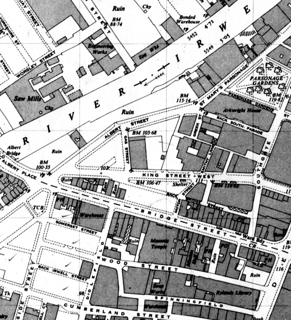
And not content I went looking for the story of the place over the century after it was surrounded by the markets.  In 1951 much of the area had suffered from the aerial bombardments of the Second World War and the OS map of that year shows areas marked “Ruins” along with heaps of open spaces and an air raid shelter on King Street West.

At the bottom of Back Bridge Street, 2025

Even here you sense chabge is on th eplanning table to which l have to say the Waggon and Horses is now Mulligans.

Southgate and surrounding streets, 1951

All a little different from Spinneyfields.

Location; Spinningfields and Back Bridge Street

Pictures; Crown Square, Southgate and Back Bridge Street, 2025, from the collection of Andrew Simpson and Wagon and Horses and New Shambles Street, 1851,  from Adshead’s map of Manchester, 1851, Digital Archives Association, http://www.digitalarchives.co.uk/ and Southgate and surrounding streets, 1951 from the OS map of Manchester and Salford, 1951

Tuesday, 22 April 2025

Lost in Spinningfields …….. with just the past as a guide

I must admit I do get confused in Spinningfields, or more accurately I get disorientated.

Looking down Hardman Street to Hardman Square, 2025

Even now almost two decades after the development began and following heaps of visits, I still lose my way and get a bit surprised at what I come across.

Looking up from Crown Square, 2025
But then most of the rebuilding happened while I was less focused on coming into town with the result that the place took off while I had my eyes elsewhere.

Added to which I remember it from the 1970s and early 80s when the area was best described as a place waiting for something to happen.

And that according to my Wikipedia began in 1997 when a property company purchased several buildings around the Rylands Library.  

The plan was to create a new business quarter and retail area which it dubbed a “Knightsbridge of the North”. *

Inevitably the business area was described as our equivalent of London’s Canary Wharf and by 2010 a report byLooking up  Manchester City Council noted that 16,000 people were employed in Spinningfields which accounted for over 35% of the City’s prime office space.**

And along with the offices, and a mix of restaurants has come residential towers and that footbridge across the river linking Spinningfields to New Bailey in Salford.

Hardman and Byrom Street, 1981

There will I guess be detractors, but I like the place, even given my ability to get confused.  It has a buzz and offers up plenty of photo opportunities but which do present challenges in matching my collection of old pictures with today.

Hardman and Byrom Street, 2024
So I looked out an image from the early 1980s of the end of anti-cruise missile demonstration.  It had begun in All Saints and snaked its way through the city before ending in Crown Square.  

The picture caught the last leg of the march as it made its way via Byrom Street, passing Hardman Street before terminating in the Square.

Standing at the corner of Hardman and Byrom Street recently it was hard to match that picture with the present.

Which I suppose explains my confusion.  It is a bit like staring through a very dirty window.  You can make out something but it is difficult to make sense of what you see.

That said the Spinningfields development has been so comprehensive that there is little left to remember, and you have to fasten on the remaining bits of the old street pattern. 

But that has a bonus because it always takes me back to explore the area in the past and that in particular in the 1840s and 50s when the area was a mix of back-to-back housing, as well as factories and markets.  Much of this was subsequently swept away with the development of warehouses, and offices which in its way was almost as comprehensive as its 21st century equivalent. ***

Hardman Street and surrounding streets, 1951
Which is where I came in, leaving me to ponder how as a resident of the area in 1851 I would have coped with wandering the streets a century later or today.

All I guess would be confusion.

Location; Spinningfields

Pictures; Hardman Street, 2025, and Hardman Street/Byrom Street in 1981 from the collection of Andrew Simpson, Hardman Street/Byrom Street, 2024, courtesy of Google Maps and Hardman Street and surrounding streets, 1951, from the OS map of Manchester & Salford, 1951

 *Spinningfields, https://en.wikipedia.org/wiki/Spinningfields

**Manchester City Council Report for Resolution, March 2010, https://www.manchester.gov.uk/egov_downloads/Spinningfields.pdf

***Spinningfields, https://chorltonhistory.blogspot.com/search/label/Spinningfields

Sunday, 20 April 2025

It’s all in the detail …… walking through Spinningfields in April


Sidney Street, Hardman Street, 2025


Welcome to Spinningfields Hardman Street, 2025 


Crown Square, 2025


Crown Square, 2025

Location; Spinningfields

Pictures; Hardman Street, Rose Street, Crown Square, 2025, from the collection of Andrew Simpson


Monday, 29 January 2024

Down at Spinningfields …….. remembering an older time

This is the corner of Hardman Street and Byrom Street sometime around 1983.

Byrom Street, circa 1983

I can’t be exactly sure of the date, but it will be in the early 1980s when it seemed that almost every Saturday there was a march and demonstration.

They ranged for calls to stop further cuts in public spending, demands for the withdrawal of US Cruise missiles and those Anti Nazi rallies.

This one was about the arms race and in particular the siting of a new generation of delivery systems for nuclear weapons by the United States Air Force here in Britain.

The march began at All Saints, threaded its way through the city before ending at Crown Square.

And this image was taken as the demonstration came to an end.

Byrom Street, 2022
Apart from bringing back memories of the time and my own impassioned youth it neatly supplied a reminder of what was here before the new Spinningfields.

Spinningfields is one of those bright shiny “new bits” of the city.

I often wander down there to take pictures and try and remember just what it was like when I first washed up in Manchester over 50 years ago.

To be honest it’s a bit of a blur and back in 1969 I don’t think I thought much of it.  It was just a  network of streets and buildings which had seen better times waiting for something to happen.

And then as you do I took my eye off the area and only returned as the developers were filling the place up with tall glass and concrete buildings, some pretty soulless open spaces and heaps of restaurants.

Byrom Street, 1893
Occasionally I would challenge myself to remember what it replaced with little success. 

But here is the answer because what is now modern buildings “more glass than wall” is the old Hospital for Consumption and Diseases of the Throat”.

I will go looking for its history, but for now that is it.

Queue for my old Facebook chum Alan Jennings, to offer up some of his priceless memories.

But I can add that, "The Hospital was established in 1875 in St. John Street, Manchester. 

It transferred to new premises in Hardman Street in 1886. In 1885 an in-patients hospital was opened at Bowdon, Cheshire, and in 1904 the Crossley Sanatorium at Delamere, near Frodsham, Cheshire, was built, named after the Chairman of the Board, W. J. Crossley, a major contributor to its cost".*

Location; Byrom Street

Picture; Byrom Street, circa 1983, from the collection of Andrew Simpson,  in June 2022, courtesy of Goggle Maps and the corner of Byrom and Hardman Streets, 1893, from the 1893 OS map of South Lancashire, courtesy of Digital Archives Association, https://digitalarchives.co.uk/

*Manchester Hospital for Consumption and Diseases of the Throat and Chest, Manchester City Council, https://www.manchester.gov.uk/directory_record/212450/manchester_hospital_for_consumption_and_diseases_of_the_throat_and_chest#:~:text=The%20Hospital%20was%20established%20in,Chairman%20of%20the%20Board%2C%20W.%20J.

Monday, 5 December 2016

On the edge of Spinningfields

I don’t pretend it’s the best picture or for that matter one with a fascinating story but that won’t stop me.

I was out on the Manchester side of the Irwell on the edge of Spinningfields.

It was sometime around half ten in the morning.

The restaurant had a few customers but none brave enough to sit outside and there was a regular procession of workmen from the many new developments wandering off to buy a coffee and second breakfast.

I am guessing that in another few hours the place would have been full.

And as we move towards Christmas I have no doubt that the other restaurants will get their fill of customers.

Location; Spinningfields

Pictures; Spinningfields 2016 from the collection of Andrew Simpson

Sunday, 4 December 2016

So what is stirring in Spinningfields? ..............

Now here is a bit of street furniture well worth looking up when the development is finished.

I would love to see the original design brief for the four structures and look forward to looking at them when they are finished and unveiled.

For now that is all you get other than to reflect on the way Spinningfields continues to change and in the process seems to recreate some of those narrow streets which were a feature of much of the city a century and a bit ago.

So for those who have wandered down there recently there is the new build between Quay Street and Hardman Square along with the one just round the corner which has the giant lampshades added to which as the HSBC has moved out across from Carlucci’s there are new bars and restaurants opening up all the time.

You can be sniffy about Spinningfields dubbing it just a version of Docklands where the buildings have no originality and remind you of any one of a dozen modern cities.

But I like it and I suspect the criticisms of it today could have been replicated by those a century and a bit ago who saw the Victorian equivalent going up in the commercial centre of Manchester and mourned the passing of those old ramshackle wood and daub properties which stretched back into the 17th century.

And that is it.

Location; Spinningfields


Pictures; Spinningfields 2016 from the collection of Andrew Simpson