Showing posts with label The Mersey. Show all posts

Friday, 25 September 2026

The Kickety Brook, Stretford, once a vital part of our flood defences


I first walked the Kickety Brook with my old botanist friend, David Bishop.

It doesn’t look much but it was vital in its day for protecting the Duke’s Canal at Stretford.

The Canal dates from the 1760s and was cut to bring coal into the heart of the city and also was used by our farmers and market gardeners to ship their produce into the Manchester markets.

But the canal was close to the Mersey which could flood with little warning. In July 1828 flood water transported hay ricks from the farm behind Barlow Hall down to Stretford only later to take them back, while later floods proved to be even more destructive with one destroying the bridge across Chorlton Brook.

It was, wrote Thomas Ellwood the local historian
“no uncommon thing to see the great level of green fields completely covered with water presenting the appearance of a large lake , several miles in circuit,” and he recorded six major floods between  December 1880 and October  1881

By then the stone weir had been in place for nearly a century.  It had been built after a heavy flood in August 1799 had broken the banks where Chorlton Brook joined the Mersey.  This had led to fears that the Bridgewater Aqueduct across the flood plain could be damaged in a subsequent flood.

The weir was designed to divert flood water from the Mersey down channels harmlessly out to Stretford and the Kicketty Brook.  Not that it always worked.  Soon after it had been built flood water swept it away and during the nineteenth century neither the weir nor the river banks prevented the Mersey bursting out across the plain.

This happened in 1840 and in the following year it was rebuilt by the engineer William Cubitt. After litigation the cost of repair was borne by the Bridgewater Trust who paid out £1,500, the Turnpike Commissioners £500, Thomas de Trafford £1,000 and Wilbraham Egerton £1,000.

Today, standing beside the weir you get little sense of the force of the river in full flood. In the winter there can be a pool of water at its base stretching out across the plain but on many occasion in the past on warm summer’s days even this bit of land can be bone dry.

And likewise the Kickety Brook seems just an overgrown and quite forgotten bit of water. The last time the weir took an overflow of flood water was 1915 when these two pictures were taken.

Pictures; Higgibotham's field in flood, 1946, from a painting by J Montgomery, 1963, m80092, courtesy of Manchester Libraries, Information and Archives, Manchester City Council, and 1915 pictures from the Lloyd collection

Thursday, 18 June 2026

Of floods and weirs and peaceful places, on the edge of Turn Moss


The weir in 1915
I really don’t do enough pictures on the blog and rarely do those then and now sort of stories.  So here with the help of Nigel Anderson and Michael J Thompson of Hardy Productions UK* are some shots of the weir on the edge of Turn Moss just where the river takes one of its dramatic twists.

Now the Mersey is prone to flooding and after a particularly bad flood in 1799 the weir was built to channel storm water across the plain and into the Kickety Brook and so lessening the danger to the aqueduct which carried the Duke’s Canal.

And floods and the story of floods regularly pop up on the blog including the tale of the weir and Kickety Brook,.

Almost the same spot today © Nigel Anderson
So when Michael told me that he and Nigel had been down at the weir I just had to ask permission to use their photographs, along with two from 1915 which was the last time it served the purpose it was built for.


Their pictures show a benign spot, but it was not always so.

The river could flood with little warning and on one occasion a farmer just had time to release his horses from the cart as the water swept across the open land.

The weir from the flood plain, 1915
Another time in the July of 1828 flood water transported hay ricks from the farm behind Barlow Hall down to Stretford only later to take them back, while later floods proved to be even more destructive with one destroying the bridge across Chorlton Brook.

It was, wrote Thomas Ellwood the local historian
“no uncommon thing to see the great level of green fields completely covered with water presenting the appearance of a large lake , several miles in circuit,” and he recorded six major floods between  December 1880 and October  1881.

Looking towards Kickety Brook from the weir © Michael J Thompson


Not that it always worked.  Soon after it had been built flood water swept it away and during the nineteenth century neither the weir nor the river banks prevented the Mersey bursting out across the plain.

This happened in 1840 and in the following year it was rebuilt by the engineer William Cubitt.

After litigation the cost of repair was borne by the Bridgewater Trust who paid out £1,500, the Turnpike Commissioners £500, Thomas de Trafford £1,000 and Wilbraham Egerton £1,000.

*Hardy Productions UK https://sites.google.com/site/hardyprodsuk/

Pictures; of the weir in 1915 from the Lloyd collection and the weir today courtesy of Nigel Anderson and Michael J Thompson


Wednesday, 11 February 2026

Crossing the Mersey in 1955 to Jackson's Boat


Like many of Derrick A. Lea’s pictures of Chorlton this one was made in the winter.

We are at Jackson’s Boat, that pub across the river and the year is 1955.

Now I have written about Mr Lea already and I keep getting drawn back to his images of Chorlton which were made in the 1950s.

They work for me on a number of different levels.

At its simplest they remind me of the style of pictures I grew up with.

But it is also that you don’t see many drawings, paintings or wood cuts of the township, so these are particularly appealing.

“The pub was built in the 18th century and so might count as the oldest in the township.  It was known variously as the Old Greyhound and the Boat House, before reverting back to the old Greyhound.  Briefly it was called Jackson’s Boat and then the Greyhound from 1834. 

The names may in part be explained by the origins of the site.    At some point a farmer called Jackson farmed the land and kept a boat for ferrying passengers across the river. 

Later still Samuel Wilton built a bridge in 1816 over the river at this point at a cost of £200.  

But the ferry and the right to transport passengers across the Mersey were still in place in 1832 when the pub and the surrounding land were put up for sale. 

The advert throws some light on how the relationship between owner and tenant. The land and pub were owned by John Marsland and tenanted by a George Brownhill who seems to have benefited from the ferry charges.  

The sale in 1832 went to Edmund Howarth who may well have placed Samuel in as tenant.”*

All of which may seem a long way from the picture, but not so.  In 1955 the bridge was free to walk across, but until the late 1940s there had been a toll, which had been there since Sam Wilton’s old bridge in 1816 and was just a continuation of the fee charged to cross the river by the ferry.

The gate was on the south side of the bridge and there are those who can just remember paying the penny to cross over, and one wonderful story of a young girl who chose to chance her luck and crossed by a more dangerous and unconventional way.

She lived in the Block which was a collection of cottages on Hardy Lane, and this seemed a quicker and cheaper alternative to a long walk or the penny payment.

Picture; Derrick A. Lea


Location; Chorlton

*The Story of Chorlton-cum-Hardy, Andrew Simpson 2012, https://chorltonhistory.blogspot.com/search/label/A%20new%20book%20for%20Chorlton

Wednesday, 20 August 2025

Defending Chorlton and Didsbury from the fury of the Mersey

Now there is a caption competition here but I leave that to the swift of mind who can call up a witty aside on the turn of a sixpence.

All I will say is that we are back in 1966 at that point on the Mersey where the new bridge crosses the river by the pub.

And not for the first time over the last few centuries work is underway on the river banks,

These have been raised and raised to protect us from the river which in the past could flood with little warning and cover the meadows in a lake which stretched for miles.

The last time this happened on our side of the Mersey was in 1912 and there are pictures of the flood water poring over the weir which had been built to protect the Duke’s Canal.

There are plenty of stories of those flash floods which during the 19th century were common enough to enter local folk lore and have been reproduced in the book on Chorlton-cum-Hardy.*

And that is about all I am going to say other than that the story of Jackson’s Boat and its many different names is covered in that book and in the latest on Chorlton’s pubs and bars.**

But I shall just finish with one last comment on the image which and has recently come to light through a new project.

Neil Simpson tells me that "the Town Hall Photographer's Collection Digitisation Project, which is Volunteer led and Volunteer staffed, is in the process of systematically scanning the 200,000+ negatives in the collection dating from 1956 to 2007.

The plan is to gradually make the scanned images available online - initially on Manchester Archives+ Flickr and later on other Archives+ digital platforms.***"

*Manchester City Council Archives+ Town Hall Photographer's Collection Flickr Album...

And that is all I have to say other than a thank you to Neil and the team.

Location; Chorlton

Picture; Down by the Mersey, 1966, courtesy of Manchester Libraries, Information and Archives, Manchester City Council, http://images.manchester.gov.uk/index.php?session=pass

*The Story of Chorlton-cum-Hardy, Andrew Simpson, 2012, https://chorltonhistory.blogspot.co.uk/2014/12/the-story-of-chorlton-cum-hardy.html 

**A new book on the pubs and bars of Chorlton, https://chorltonhistory.blogspot.co.uk/2017/05/chorlton-pubs-and-bars-book-has-arrived.html

***Manchester City Council Archives+ Town Hall Photographer's Collection Flickr Album...

Sunday, 6 July 2025

Of floods, tall embankments and dramatic happenings across Chorlton

Now anyone who walks the Meadows will have wondered at some stage about the tall embankments that run the length of the Mersey.

The Mersey, 1966
The river, which in the summer seems a gentle and benign strip of water, can in winter become a torrent, which some years threatens to over top even these tall flood walls.

And over the centuries they have done just that. 

In 1799 a particularly powerful flood, broke through the embankments along the Chorlton and Sale sides of the Mersey, while fifty years later another destroyed the weir which had been built to protect the viaduct of the Duke’s Canal.

And there are plenty of photographs from the early 20th century showing the extent of these floods including some from 1915 when the weir was last over topped and others showing vast stretches of land reduced to a great lake.

Our own historian, Thomas Elwood described a number of severe floods in the early 1880s and described in detail the dramatic events on June 14th, 1828, when the Mersey broke its banks near Barlow Hall, above Jackson’s Boat, during hay harvest time.*

The Mersey, 1828
The event occurred at about six on the Sunday evening while farmers were busy leading the hay.

The water rose so quickly that the horses had to be taken out of the carts and made to “stampede” to the nearest high ground.

The hay was carried down river lodging against the banks, where men, women and children assembled to rescue it but to no success.**

The Mersey, 1991
A George Lewis of Streford who had gone with his horse and cart to collect hay from the Ouzel meadow was caught by the flood and was trapped there till the morning while another Stretford man took refuge in a birch tree and was rescued the following day.

All which points to the importance of those embankments.  That said, it is unclear when they were built, but it is most likely they are very old and have been worked on over the centuries.

The Stretford Manor Court Records dating back to 1700 frequently mention the raising, thickening and mending the banks, while the name Wall roods for a field adjoining the river in Stretford, close to the weir is traceable as far back as 1588. ***

The Mersey, 2009
And according the historian T H Croften, in the adjoining township of Urmston, “at the Halmot, on October 5, 1614, amongst the officers appointed were both ‘Overseers of Watercourses’ and Banklookers’, whose duty was to make presentments to the Court" respecting any offences in their separate departments, respecting neglect of the water courses and ditches and the banks.

While Mr. Fletcher Moss in his book on Didsbury noted records kept by one of the parish clerks referred to the strengthening of the land between Northdenden and Gatley at nine shillings an acre in 1771 and the strengthening and repair of other parts of the banks.

Chorlton Brook, 1960
Leaving Crofton to add that “in 1840, when times were bad and work scarce, the local landowners joined together and made an assessment on their lands to raise funds, which enabled them to employ the poor all winter in raising the banks.  Probably the banks had been injured by the flood of August 1840, which had swept away the old overflow weir near the confluence of Chorlton Brook”. ****

More recently the banks along the Chorlton ees were also worked on, but sadly I can’t remember when.

Location; Chorlton

Picture; Down by the Mersey, 1966, courtesy of Manchester Libraries, Information and Archives, Manchester City Council, http://images.manchester.gov.uk/index.php?session=pass, the Mersey in 1991, courtesy of David Bishop, and in 2009, from the collecion of Andrw Simpson, 
the Junction of Gore [Chorlton] Brook and River Mersey, 1963, M80140, courtesy of Manchester Libraries, Information and Archives, Manchester City Council, http://images.manchester.gov.uk/index.php?session=pass

*T L Ellwood, Chapter 1, History of Chorlton-cum-Hardy, November 5, 1885, South Manchester Gazette,

**Dreadful Effects of the Late Storms, Manchester Guardian, July 27 1828

***Crofton, T L, A History of the Ancient Chapel at Stretford, 1899, page 31

****ibid Crofton, page 34

Sunday, 29 September 2024

Today I walked the old road ........ part two

The road twists and turns following the old field divisions and natural obstacles before running up beside the river bank.

Junction of the Gore [Chorlton] Brook, 1963
This was our first warning of the power of the Mersey. For here there is no gentle river bank sloping down to the water’s edge.

 Instead the road hugs a towering bank built and added to over the centuries as the main defence against a powerful threat to the lives and livelihoods of all those who lived beside it. Generations of farmers have laboured to construct this natural wall to repel the flood waters of the Mersey.

The village and the isolated farms were all built beyond the flood plain. Even so this was not always sufficient protection. The Mersey has on countless occasions risen and breached these towering banks sometimes even sweeping away the defences themselves.

It was for this reason that the weir was built. Just beyond the point where the Brook joins the Mersey and at a bend in the river the weir was built to divert flood water from the Mersey down channels harmlessly out to Stretford and the Kicketty Brook.

Not that it always worked. Soon after it had been built flood water swept it away and during the nineteenth century neither the weir nor the heightened river banks prevented the Mersey bursting out across the plain.

 In July 1828 the Mersey flood water transported hay ricks from the farm behind Barlow Hall down to Stretford only later to bring them back, while later floods proved to be even more destructive. It was, wrote Thomas Ellwood the local historian
“no uncommon thing to see the great level of green fields completely covered with water presenting the appearance of a large lake , several miles in circuit.”


Painting; Junction of Gore Brook and River Mersey, 1963, M80140, courtesy of Manchester Libraries, Information and Archives, Manchester City Council, http://images.manchester.gov.uk/index.php?session=pass

Montogomery is incorrect, at the point where it joins the Mersey it has become Chorlton Brook

Sunday, 10 July 2022

The not so safe bridge over the Mersey circa 1865


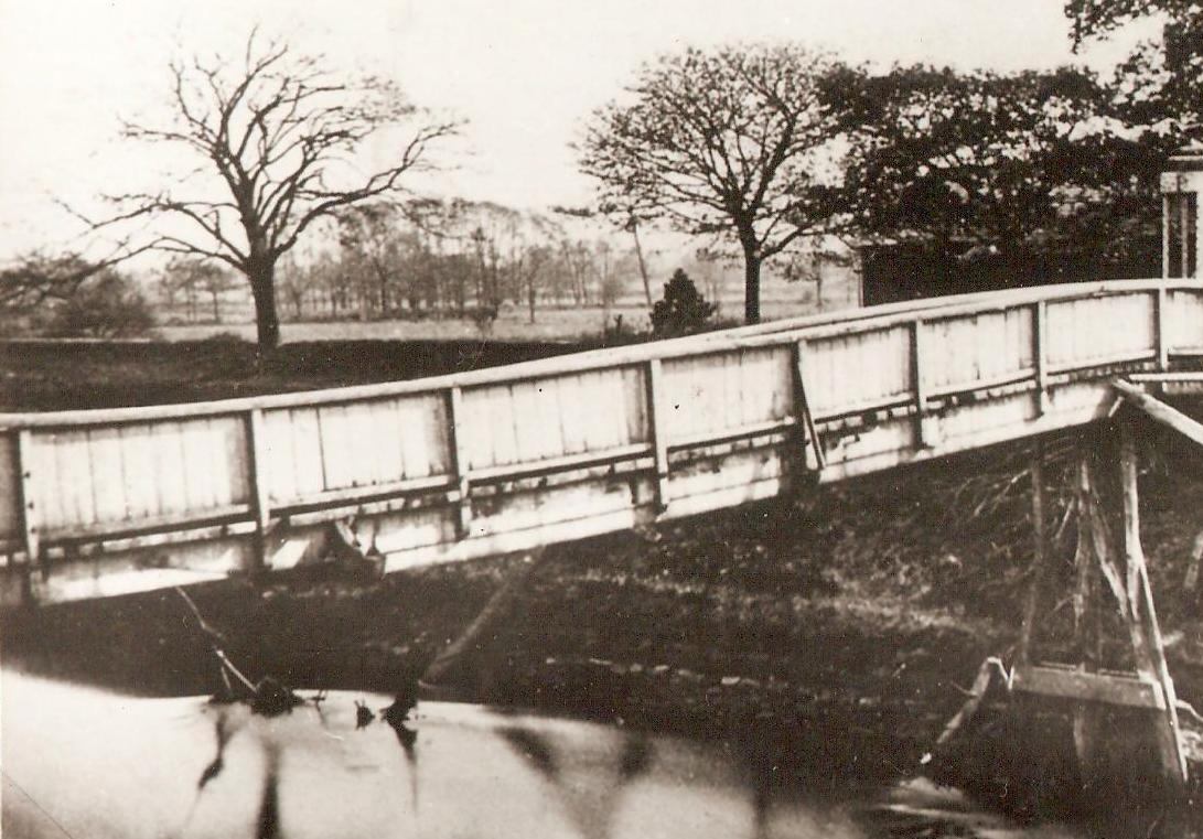
The old bridge 1865
This is one of the oldest pictures in the collection and dates from 1865.

We are on the bank of the river Mersey and just beyond the bridge is the pub.

“The pub was built in the 18th century and so might count as the oldest in the township.  It was known variously as the Old Greyhound and the Boat House, before reverting back to the old Greyhound.  Briefly it was called Jackson’s Boat and then the Greyhound from 1834.

The names may in part be explained by the origins of the site.    At some point a farmer called Jackson farmed the land and kept a boat for ferrying passengers across the river.


The pub sometime after 1881
Later still Samuel Wilton built a bridge in 1816 over the river at this point at a cost of £200.  

But the ferry and the right to transport passengers across the Mersey were still in place in 1832 when the pub and the surrounding land were put up for sale.

The advert throws some light on how the relationship between owner and tenant. The land and pub were owned by John Marsland and tenanted by a George Brownhill who seems to have benefited from the ferry charges.  The sale in 1832 went to Edmund Howarth who may well have placed Samuel in as tenant.”*

The old bridge and the missing central support 1865
And so back to the bridge which by 1865 was in a pretty poor state.

The central section had been swept away and judging by the way it slops down in the middle could not have made travellers feel particularly safe.

It did however survive until 1881, although the loss of the support on the Chorlton side a year earlier made a new bridge a necessity.

This was opened on October 14th 1881 which was all to the good given that the old one was washed away a few hours earlier.

But the new one like the old one had a secure door at the southern end which the landlord would open only after having been paid the toll.

Pictures; from the Lloyd collection

*THE STORY OF CHORLTON-CUM-HARDY 

Saturday, 14 May 2022

So farewell then to that bridge across the Mersey

No more [maybe] will countless thirsty walkers walk your way.*

Crossing the water, 1960
I have known you for over 40 years

And across your wooden planks 

I have happily sped to that pub over the River.

You date from the 1880s, and replaced

Sam’s Wilton’s wooden bridge of 1816

And both of you made it easier to cross

Making redundant that rowing boat

That countless landlords used to ferry 

Those wanting to cross the Mersey

Who still had to pay a bridge toll to walk over the water till the 1940s

Mr Wilton's bridge, date unknown
But now I read you are deemed unsafe

And “ the Engineers recommendations include 

A permanent repair or bridge replacement

With a review and a decision in due course

A temporary bridge installation would cost in the region of circa £220,000. ”**

I wait to know your fate.

Location; Chorlton

Pictures; the bridge over the water, 1960, Courtesy of Manchester Archives+ Town Hall Photographers' Collection, https://www.flickr.com/photos/manchesterarchiveplus/albums/72157684413651581?fbclid=IwAR0t6qAJ0-XOmfUDDqk9DJlgkcNbMlxN38CZUlHeYY4Uc45EsSMmy9C1YCk and Sam Wilton’s bridge date unknown, from the Lloyd Collection

*In homage to E.J.Thribb, the poet-in-residence at Private Eye. The character was created in 1972 by Barry Fantoni, who wrote the poems until 2010, when he was succeeded by other staff members

**News from Chorlton Park Ward Labour Party, If you would like to get in touch with us directly please feel free to email,cllr.joanna.midgley@manchester.gov.uk, cllr.dave.rawson@manchester.gov.uk cllr.mandie.shiltongodwin@manchester.gov.uk


Sunday, 27 March 2022

Crossing the Mersey at Jackson’s Boat

Now I am pleased the bridge over the river has survived, despite plans to demolish it.

It dates from the 1880s, replaces an earlier wooden one built in 1816, and saved travelers having to call out the landlord of the pub who would ferry them across the water for a small fee.

Not that the erection of the bridges deprived him of the lucrative service of acting as the ferry man, because both bridges could only be traversed by paying a toll which was only abolished in the late 1940s.

I remember being told by a friend that his grandmother had evaded the toll by climbing on the bridge and working her way along by holding on to the girders.


This picture of the bridge is new to me.  It was taken in 1960 and I smile every time I read the notice.

Location; The River Mersey,

Picture; the bridge over the water, 1960, "Courtesy of Manchester Archives+ Town Hall Photographers' Collection", https://www.flickr.com/photos/manchesterarchiveplus/albums/72157684413651581?fbclid=IwAR0t6qAJ0-XOmfUDDqk9DJlgkcNbMlxN38CZUlHeYY4Uc45EsSMmy9C1YCk 


Saturday, 8 November 2014

Crossing the Mersey back in 2012 with the Metro line

Now my much advertised trip on the newly opened tram service from Chorlton to the airport never happened.

I was all set; with camera charged and keen to take advantage of that glorious November sunshine which I reckoned would show the metro stops and the surrounding landscape off to their best.

But for very mundane and boring reasons it didn’t happen.

So the plan is for today and unlike Monday when it was just an adventure today there is a purpose.  We are off to meet our Saul at the airport and with Josh and Polly over from Sheffield and Ben and Ania around the tram seems a plan.

And as you do I was thinking back to the early days of its construction which for many was a tedious round of disruptions along the Barlow Moor Road, Hardy Lane and Mauldeth Road West corridors.

There were frequent diversions, and long waits at the traffic lights, but while all this was going on out by the meadows the engineers were working on crossing the river with the metro line.

Now I know of friends who went for regular walks just to watch the progress of the work and we managed one trip on a warm summer’s evening.

I should have taken a camera but didn’t so I am pleased that Andy Robertson did and captured the construction one July day back in 2012.

Andy regularly supplies some wonderful pictures for the blog and specialises in recording moments in our history which will soon just be a memory.

His series on the new build at Oswald Road, and his current projects recording the development down at Darley Avenue and our closed and endangered public lavatories are the stuff of history.

So that is it, just one day in the story of the Metro Mersey crossing, now just a memory.

Pictures; the metro crossing of the Mersey under construction, July 2014, from the collection of Andy Robertson

Saturday, 30 March 2013

The pub beyond the river, a ferry and a bridge


Hardy Lane circa 1912
On a warm summer’s evening a walk across the meadows to the Mersey and the pub beyond the river is one of those pleasant things to do.

Although walking back in the dark can be an adventure and one which more than once has left at least one of us down the ditch at the side of the lane.

And I guess it was ever such because the pub has been serving beer from the beginning of the 19th century and most probably before that.

The small community which lived in Hardy and those from the village who fancied a walk out with a drink at the end of it will no doubt have known it well.

But any one drinking there before 1816 would have had to rely on the ferry across the river until Samuel Wilton built his bridge.  Now Sam Wilton was canny and maintained the toll once charged by the ferry man and to ensure he got his money he added a stout door on the southern end hard by the pub.

The old bridge in 1865,  built in 1816
Nor was this charge dropped when the new bridge was erected in 1881 so while the door became an iron gate the toll remained and did so until well in to the late 1940s.

But I suspect the sale of beer was always secondary, and the prime money spinner for the tenant landlord was the land along with the crossing charge.

So Samuel Nixon who was there in the 1840s and 50 described himself as a farmer and according to the tithe schedule of 1845 tended nine acres of orchard and meadow land.

Now nine acres put him amongst the 60% of market gardeners in the township who farmed between one and nine acres of land growing the crops the city wanted to eat.


The old bridge and toll door, 1865
Of course like a handful of others he had diversified into other occupations as well as farming.  In his case this was  the crossing toll and the sale of beer.


I don’t know when Samuel Nixon took over the pub but it may have been when the place was sold in 1832.

He may even have seen the advert which led to Edmund Howarth buying the land, the buildings and of course the right to charge that toll.

It is a fascinating piece of history and well worth reproducing.

“By Mr. Nathaniel Pass, by order of the trustees named by the will of James Marsland, deceased at the house of Mr. George Brownhill, known by the name of Jackson’s Boat in Chorlton-with-Hardy, in the county of Lancaster, on Monday the 5th day of March, 1832, at five o’clock in the evening subject to conditions to be then produced.

The land around Jackson's Bridge 1841-53

The Inheritance in Fee-Simple or and in all that long established  and well accustomed Public-House, known by the name of Jackson’s Boat, aforesaid, with the outbuildings, garden, orchard, and several closes of Land thereto belongings, called the Bank, the Nearer Ford Mouth, Further Ford Mouth, and the Further Field, situto in Chorlton-with-Hardy aforesaid, but lying on the southerly or Cheshire side of the River Mersey, and containing together with the site of the said buildings, by recent admeasurement, 5a.2q. 16p of land, of the Lancashire measurement, or thereabouts.  

Together with the Ferry thereto belonging, and the right and priviledge of carrying passengers over the river Mersey, in the occupation of the said George Brownhill, as tenant.

And also all that Field or Parcel of LAND, called the Boat Field, situate in Sale in the county of Cheshire, containing 3a 0q. 14p. Of land, of the measure aforesaid, or thereabouts, in the occupation of John Marsland, and adjoining the land before mentioned.

The house and land in Chorlton-with-Hardy will be sold subject to an annuity of £26. 13s. 8d., payable during the life of a widow lady, aged 46 in April next.  The buildings are in excellent repair, and the land is of the first rate quality.
The pub circa 1881

The tenant of the public house will shew the premisises; and for further particulars apply to Mr. Marsland, or Mr. Samuel Alderley, of Sale; or to Meesrs. PASS and Shelmerdine, Althrincham.”**

Manchester Guardian February 18, 1832

At the time the pub was called Jackson’s Boat but it had during the early 19th century other names, including the Old Greyhound and the Boat House, before reverting back to the old Greyhound.  Sometime around 1832 it became Jackson’s Boat and then the Greyhound from 1834.

Just another of those wonderful ways history has of surprising you.

*The not so safe bridge over the Mersey circa 1865, http://chorltonhistory.blogspot.co.uk/2013/03/the-not-so-safe-bridge-over-mersey.html


**Manchester Guardian February 18, 1832

Pictures; from the Lloyd Collection and map of the land around Jackson's Bridge, courtesy of Digital Archives, http://www.digitalarchives.co.uk/