Showing posts with label Martledge. Show all posts

Tuesday, 27 October 2026

Walking in the north of the township in to Martledge in the summer of 1847, part one


Barlow Moor Lane, north to Martledge, a journey which will take in some great houses, a shop, farms and a pub as well as cottages of wattle and daub and brick

Barlow Moor Lane is a long road.

Standing at the point where the Row joins Barlow Moor Lane we have a choice, turn north and journey on to Martledge and then out of the township by various routes to Hulme and
Manchester, or south to Hardy Lane and on to the Mersey, Withington and Didsbury.

Martledge is much overlooked in most histories of the township so north it is.

And we will start with the Holt estate again.  Leaving the Row and heading north up Barlow Moor Lane we follow the east wall of the Holts, all the way to Lane End.  Everything on this side of the road dates from after 1908 when the last of the Chorlton Holts died and the estate sold off.

It finished at Lane End.  Directly opposite where today Sandy Lane begins was the grocer’s shop of Jeremiah  Brundrett.  It was a large house at one time known as Lilly Cottage.

The Brundrett’s were there long enough for the spot to become known as Brundrett’s corner  Facing the shop roughly on the site of the church was the home of Caleb and Ann Jordril.   Here was one of the last wattle and daub cottages.

Continuing north along the lane our journey would pass open fields until we reached the edge of Martledge.

Here to our left was Clough Farm and on our right Oak Bank House.

The farm stood roughly between Groby Road and Silverwood Avenue.   In that summer of 1847 it was occupied by Margaret Taylor and it would have been her farm land we would have seen as we walked up Barlow Moor Lane towards her home.

Today all of the land from Silverwood Avenue back towards High Lane and right back to Lane End was rented by her from the Egerton Estate.  There were 10 acres in all and it was a mix of arable, meadow and clover and included part of Scotch Hill.

Margaret was forty-seven.   Hers was no easy life.  To make 10 acres of land work and bring in a living required hard work.

Over and above the big points in the agricultural year of sowing, planting and reaping, there were the constant demands of weeding, chasing off pests and the journeys to the markets in Manchester.

These were tasks usually carried out by the whole family, but during the 1840s, she lost both her parents and two sisters which left her with just her 11 year old nephew.   Now Margaret was not alone in facing such loss, or in bringing up the child of her a relative.

Easing the chronic overcrowding meant that at least one child might be farmed out to relatives and Edward her nephew had been at Clough Farm since he was five and would still be there when he was 15 by which time she had married John Stretch.

From their fields they would have been able to gaze across at Oak Bank, one time home of William Morton and later the Cope family.  Oak Bank was a substantial building standing in its own grounds close to the modern junction of Barlow Moor and Wilbraham Roads.

Nothing now exists of the house but the path leading to it is now Needham Avenue. The house was situated in a garden which covered the area running on either side of Needham Avenue as far as Barlow More Lane in one direction and Corkland Road in the other.

The estate also included a large meadow field and small wood stretching back from Needham along Barlow Moor Lane to Lane End.

It had belonged to William Morton who had been there since 1821, but on death his will stipulated that the house and land had to be sold within five years.  

When this happened is not known but in 1845 a Miss Crofton was there paying rent to the Executors of Mr Morton.  

By 1847 the house and land were in the possession of Frederick Cope who rented both to John.  This was a short term arrangement and by 1850 the Cope family were living at Oak Bank.

William Morton had described himself as a member of the gentry.   Frederick Cope was a wine merchant who ten years earlier had been living with his wife and children on Oxford Street, close to where the University now stands.  Elizabeth had died by 1851.

Adapted from THE STORY OF CHORLTON-CUM-HARDY, http://chorltonhistory.blogspot.co.uk/search/label/A%20new%20book%20for%20Chorlton

Pictures; map of Barlow Moor Lane, courtesy of Digital Archives, http://www.digitalarchives.co.uk/  picture of Jeremiah  Brundrett, Wesleyan Handbook, 1908, courtesy of Philip Lloyd, and gravestone of the Morton family in the parish churchyard, from the collection of Andrew Simpson

Thursday, 17 September 2026

That lost picture of the Royal Oak in 1902 with young Thomas Kelsey

This is a picture of the old Royal Oak I have never seen before.

The caption gives a date of 1902 and refers to “the boy Thomas Kelsey, son of the landlord of the inn at the time.”

Now it is very unusual to be able to name a person in a Chorlton photograph from the early 20th century.

Usually we are just presented with a sea of faces whose identities are lost in time.

But this is different.

Thomas was born in 1893 in Salford and his parents ran the Duke of York pub at 186 Regent Road, before moving in 1895 to the Royal Oak here in Chorlton.

The pub trade ran deep in the family, Thomas’s father was working in the Glass House on Regent Road by 1881 when he was 18 years old and his parents had run a beer shop just off Regent Road.

But what makes this picture all the more interesting is the detail which it reveals about the pub.

The Royal Oak was originally a beer shop which dated back to the early 1830s and consisted of little more than four rooms.

But what intrigues me is the building behind which seems to have been added on by the 1890s.

The OS map for 1894 and 1907 show that pub had been enlarged and the 1911 census return records that there were eight rooms.

Nor is that all because George Kelsey appears to have been more than just a publican because the sign to our right announces that he was also in the business of “CABS, HANSOMS” and offered a LIVERY STATION.”

By 1921 the secondary business had morphed in "Kelsey Brothers" with Thomas describing himself as a "motor mechanic", a job he was still doing in 1939, by which time he was living with his wife Muriel and daughter at 6 Rippenden Avenue.

And  the premise had relocated to  what had been Renshaw's Buildings which had once been entirely residential but at some time the front had been converted into a garage.

This building was demolished sometime in the late 1920s or early 1930s and replaced by the present Royal Oak Pub, but in one picture the name Kelsey Brothers appears over the garage.

His father and family were still in the old Royal Oak serving up beer and cheer in 1921.

And like so much of the early 20th century the Kelsey family have progressed with the times, so while George Kelsey had run a beer shop his son had moved into the "motor trade" and his granddaughter was a clerk dealing with W

That said there is that finger print just below the sign, now that would be a real detective story.

Picture, the Royal Oak, 1902, m50447, courtesy of Manchester Libraries, Information and Archives, Manchester City Council, http://images.manchester.gov.uk/index.php?session=pass and Barlow Moor Road circa 1920s from the collection of Rita Bishop

Sunday, 5 July 2026

Renshaws Buildings in Martledge


Even I have to admit that this bit of road and kerb stone is not the most exciting picture of Chorlton and yet it is all that is left of Martledge that part of the old township which ran from the four banks down to the library.

All this week I have been writing about the place and today I want to focus on the building which ran along the side of this bit of road.  It was a block of six or maybe 12 dwellings and was variously known as New Buildings or Renshaws Buildings.

It was set at right angles to what is now Barlow Moor Road and in its time must have looked the part. It had a large impressive gable end and despite being farm cottages dominated this part of Martledge.

The block was owned and may have been built by John Renshaw sometime before 1832.  He was a market gardener living in a farm house on the Row* who also owned a number of cottages around the township.  Some at least would have been wattle and daub structures but Renshaws Buildings were made of brick.

Now I can be fairly confident that they predate 1832 because they are listed as part of his property qualification which entitled him to a Parliamentary vote in the newly reformed House of Commons.

And it maybe that they represent the first building boom here in Chorlton in the 1840s and 40s by speculative tradesmen who wanted to cash in on the population increase or maybe just the desire of local people to live in a house made of brick rather than wood, mud and straw.


It is unclear how many units there were but the evidence from the census and the old maps suggests that they were one up one down back to back dwellings.  By the beginning of the 20th century part of the block had been converted into commercial use and just before their demolition this bit was a garage.

They came down sometime in the 1920s or 30s to make way for the present Royal Oak pub.  I wish we had some written memories of what they were like but sadly we don’t.  On the other hand we do have a few photographs from the late 19th and early 20th centuries along with details of who lived there from the 1840s and the rents they paid, but for all that it is back to the book where you can see Barris’ reconstruction picture of Renshaws Buildings in more detail.  It is based on a number of the photographs and maps and we are looking at it from the west, as if were heading into the township from Manchester.  The kerb stone and narrow road are hidden on its eastern side.

*Today this is Beech Road and his home was on the site of Ivy Court facing the Rec

Pictures; from the collection of Andrew Simpson and Barri Sparshot

Friday, 3 July 2026

A lost photograph and a clue to a vanished building

Sometimes you fall across a picture by chance which fills in a gap in your knowledge and at the same time is a joy to look at in its own right.


It is also unusual in that it is not one I have seen before and I doubt that at first glance many today would be able to place it.

 It is a postcard sent in the summer of 1905 and shows that section of Barlow Moor Road running north from the junction with Wilbraham Road towards what would now be the library.

There is little that is familiar. But perhaps the first clue is the building of John Bailey, joiner and cabinet maker. It is still there today but is now the solicitor on the corner of Barlow Moor and Warwick Road. 

Adjoining the building and further down Barlow Moor Road there are other buildings which are still there today albeit with some changes.

All of which leaves the two buildings beside Bailey’s the joiner behind the chap leaning on the fence. The white building set back is the old Royal Oak which had been selling beer from early in the 19th century.

It was here in the 1860s that drunken mobs from Manchester had to be chased off by locals and earlier still the scene of a pub theft which resulted in the convicted thief being transported.

But it is the building to the right of the Royal Oak which really caught my attention. This is Renshaws Buildings owned by a local farmer who lived on the Row.* It dates from the very early 1830s and maybe even older.

It was one of a number of properties built for rent by local businessmen like Renshaw the farmer, Brownhill the wheelwright and Grantham the tailor.

They may have been the first wave of new brick built cottages, replacing the old wattle and daub properties and aimed at the increase in population in the township.

These were for the local market and the census returns show that they were inhabited by farm labourers and tradesmen.

I cannot be sure of when Renshaws Buildings went up but we can be sure they were in place by 1832 because their ownership along with other properties guaranteed Renshaw a property vote after the 1832 Reform Act

Looking at the number of units in Renshaws Buildings and the number of families recorded in the census record they have been one up one down dwellings in a block running at right angles to the main road.

The picture may also be unique in that it could be the last time it was photographed like this.

Within perhaps ten years the front had been converted into a garage and by the late 1920s had been demolished to make way for the new Royal Oak.

Today the only evidence that it was ever there is the kerb running down the south side of the pub.

So there you have it, this postcard from 1905 remains one of the best images of Renshaws Buildings, a building which I have followed from its construction sometime before 1832.

*Chorlton Row is now Beech Road

Picture; Renshaws Buildings and the Royal Oak circa 1905, from the Lloyd Collection

Saturday, 7 February 2026

The Booth family .............. a new family for a New Chorlton


I have been trying to clear up a few little mysteries about the Booth family who lived here on Manchester Road during the time when the township went through its most dramatic transformation.

This was when we leapt from being a small rural community into a suburb of Manchester and those tall rows of terraced and semi detached properties in long roads went up catering for the middling people who worked in the city but still wanted to live on the edge of the countryside. The Booth family saw all of that and despite still being here in the early 1940s I lose them after The Great War.

I came across Aaron Booth some years ago when I added four of his photographs to the collection.  They were taken in the summer and winter of 1882 of Martledge which was that part of the township from the four banks down to the Library.

And that was pretty much it.  I knew he and his family lived at Sedge Lynn which was an impressive Victorian house on Manchester Road and that he was businessman.

Then as you do I became more curious.  They were one of those new families with money behind them and business interests in the city who had made their home here just as the housing boom of the 1880s was about to take off.

We can track the family across the city from 1861 and during the next twenty years they lived in a succession of comfortable addresses on the edges of the city finally moving to Sedge Lynn in the November of 1881.
Before that date the evidence trail is a little vague but I am fairly confident that Aaron married Emma in 1853 and their first child was born two years later followed by another ten children.

These were the years when the family firm prospered.  In 1861 his packing company employed four men and seven boys and over the next few decades his work force increased as did the number of premises.  So while in 1863 he was located on the corner of South Street* and Albert Square by the 1890s he was listed at “3 & 6 Hall street, 20 Oxford st, St Peter’s, 12 St Peter’s square and 1 & 47 Lower Mosley Street.”

And by 1911 at the whole corner of Oxford Street and Lower Mosley Street as well as Hall Street and Chepstow Street.  On his death in 1912 he left £1,827 in personal effects.

All of which suggests that they were a comfortably well of Victorian family.  Sedge Lane was a detached house which in 1881 stood in splendid isolation in what was pretty much open land.  To the rear were the Isles a mix of ponds, tiny streams and fields which stretched up to Longford Hall, and to the west and east they were bordered by farms. It had had eleven rooms as well as a bathroom and kitchen and commanded an annual rent of £28.

And I have no doubt that they participated in the life of the community.  Aaron was an amateur photographer and it is reasonable to suppose that the rest of the family filled their leisure time with all sorts.  The 1911 Kemp’s Almanac for Chorlton boasted a host of cultural organisations from operatic and drama societies to a range of sporting ones and the city with its theatres was less than 15 minutes away on the train.

The children either followed their father into the family business or took up that increasingly suitable occupation for young women of teaching.  All of the girls lived at home and so is tantalizing to speculate on whether they taught in the local school or one of the new academies or crammers which were opening up across Chorlton to cater for the young middle class.

In a grimmer way they were also typical of the period.  Emma was just 49 when she died, and two of the children died even younger at 21 and 22.  In all ten of the family are in Southern Cemetery.  They were buried there between 1881 and 1942 in two plots close to Nell Lane.

But two of the children are not there and so far have eluded me as has the identity of the Miss Booth who originally made available the four 1882 photographs.  And then there is the mystery of where they lived after the Great War.  Aaron died in 1912 but there is evidence that they were still there at Sedge Lynn a little later, but by 1919 or 1920 they had gone.  This much I can be confident of because by 1920 the new impressive Savoy cinema had opened on the site of Sedge Lynn.

In the way of things some of the mysteries will be solved.  Out there in a parish magazine or in the local press will be a reference to them and when I next get into Central Library there will be the electoral registers which may place all of the children in the years after 1928, so still a lot to go on then.  And on the next fine day I will take myself off to the cemetery.

Which just leaves one last loose end.  In May 1969 the company Shepley Booth & Associates Ltd was wound up in Birmingham.  I have no way of knowing the connection but I am sure there is one, as each of the male sons of Aaron and Emma were given Shepley as a second name, so one more mystery.

And here is an addition which has only just occurred to me and changes the date of when I thought this picture was taken. As late as 1894 what we now call Nicolas Road was a thin strip of land with trees, running back from where the old bit of Manchester Road joined Barlow Moor Road ad onto open land.  At this stage Oswald Road stopped just beyond Vincent Avenue.

By 1907 it is shown as a path and possibly an unmade road with houses roughly where the Health Centre is.

All of which changes the date of the picture which I had always assumed was 1882 which is the date on a similar print but there in the distance is what I think is Oswald Road School which was completed in 1908.  Just goes to show!

Pictures; Sedge Lynn the Lloyd collection, the work place of the Booth family on the corner of Oxford Street and Lower Mosley Street, circa 1900 from Goads Fire Insurance Maps, courtesy of Digital Archives, http://www.digitalarchives.co.uk/ and 47 Lower Mosley Street where the Booths were also listed in 1895, photograph by H W Beaumont 1964, Courtesy of Manchester Libraries, Information and Archives, Manchester City Council m02925

*now Southmill Street

Sunday, 25 January 2026

A pub ... a farm.... and that walk through Chorlton-cum-Hardy in 1881

Now I grant you this isn’t the zippiest of titles, but it does the business.

We are standing at the junction of Barlow Moor Road and Wilbraham Road, looking up towards Martledge and the year is 1881.

Wilbraham Road was still relatively new having only been cut a decade and a bit before, but had already begun to attract some wealthy residents who settled along the stretch from Edge Lane towards Barlow Moor Road.

And that fulfilled the expectations of the Egerton estate who in the 1850s had considered a route which would run from Stretford through to Fallowfield, creating a new highway which could better connect Chorlton-cum-Hardy to Wilmslow Road and in turn open up the township to new developments as well as the possibility of more trade.


There had been a series of alternatives , all of which favoured a route to the north of the one built, but all seemed to have been abandoned possibly because the land was dotted with small water courses and ponds which had given the area the name of the Isles.

As it was the route chosen sliced through Manchester Road which ran away from the village and up to West Point and which by degree passed through Martledge which was one of the three hamlets which made up Chorlton-cum-Hardy.

Today, on a wet grey day when the rain clouds touch the tops of the houses, the best way to get a sense of the area is street google, which offers up a map, a satellite view and of course pictures of the properties along the way.


But I have the 1881 map, commissioned by the Withington Board of Health which is both very detailed and very attractive.

And because I can I have chosen to look at the bit which today is a mix of residential and commercial properties, including that car park.

I won't insult any one by commentating on the details that map reveals or a then and now commentary, anyone interested can do that for themselves.

What does fascinate me are the houses along that bit of Manchester Road which vanished under the car park and the long greenhouse behind the old Royal Oak which stood to the north of the present pub and had been dispensing beer and cheer from the early decades of the last century.

The present pub stands on the site of Renshaws Buildings which were a collection of ten back to back cottages which were constructed sometime before 1832.

Leaving me just to wander up Barlow Moor Road to where it joined Manchester Road and stand by the guidepost.  


And here the map throws up one of those tiny bits of history I like.  Back then the post faced a tree lined field, which today is the Co-op Undertakes, and was from 1920 a cinema, which in turn replaced a grand house called Sedge Lynn.  

This was the home of Aron Booth who in the summer and winter of 1882 took a series of photographs of Martledge of which only four have survived.

The Booth’s were one of those new families with money behind them and business interests in the city who had made their home here just as the housing boom of the 1880s was about to take off.


A housing boom which in a few short decades would not only engulf Martledge in rows of houses and shops but ensure that the name of the hamlet was forgotten, so that when people talked about the area they preferred to call it the new town or new Chorlton to distinguish it from the older community which lived around the village.


But what the map shows is that Sedge Lynn was built sometime between the beginning of 1881 and the April of that year, because the house is not there on the mapbut the family show up on the census return which was completed in April.

Leaving me just to trawl the Rate Books to confirm that date.

Location; Chorlton-cum-Hardy

Picture; Martledge, 1881,  from the map of Chorlton-cum-Hardy, 1881, Withington Board of Health, courtesy of Trafford Local Studies Centre Sedge Lynn and the view across the Isles towards Longford Hall  in 1882 courtesy of Miss Booth, from the Lloyd Collection


Friday, 16 May 2025

A chance find and the beginnings of a story on Wilbraham Road

Now this is a story that has yet to find an ending and in the telling will eventually reveal much about how and why Wilbraham Road follows the course it does.

The three proposed routes crossing close to Red Gates Farm
I have always taken this long road which stretches from Chorlton up to Fallowfield for granted.

After all it was cut in the late 1860s and so is pretty much one of the features of the area.

Our own historian Thomas Ellwood writing in 1885 confined himself to the observation that “it was formed some sixteen years ago by the late Lord Egerton, father of the present earl. It extends from Wilmlsow-road at Fallowfield to Edge-lane, along which a main sewer runs to within a short distance of the railway bridge at Chorlton station.  

From here it passes through the fields to Barlow Moor-lane, adjoin Lane-end, crossing High-lane, Cross-road and Beech-road, thence through various gardens, finally emptying itself into the Chorlton Brook at a point about 200 yards below the bridge which crosses the stream to Jackson’s Boat.”

So as far as Mr Ellwood was concerned the road was less interesting than the sewer which ran beside it.

I on the other hand have long been intrigued by why it was built and the benefits it might have brought to the township.

But other than clocking the date it was cut that was about it, until recently when going through the Egerton Papers in the Archives at Central Ref I came across a map showing the proposed route.

It is dated 1853 and actually shows three possible routes all to the west of the current line.

The description is less than helpful confining itself to just “plan of projected new road from Rusholme to Stretford” and there are no accompanying notes.  Now these may be elsewhere in the papers and so I will have to go off and look.

And until I find those notes I cannot be sure why three routes are shown.  All three are close together.

The first marked in blue would have crossed Martlege just below Red Gate Farm where the Library now stands and the other two coloured in brown and red just a little further to the west and two would have involved crossing Longford Brook.

Martledge, Renshaw;s Buildings now the the Royal Oak
Now why none of these routes was chosen is as yet unclear, there may have been issues with the land especially around the Isles** or it may it may have been because they ran close to Red Gate Farm and crossed Longford Brook.

All of which is one of those little bits of history yet to be uncovered.

That said the map is a wonderful source of information about the outer reaches of the township showing each of the properties and the fields, and natural features either side of the proposed routes.

So along with searching for more on the planned road I will be returning to our 1853 map.

Picture; detail from the plan of projected new road from Rusholme to Stretford, Egerton Papers, M24 /1/15 1853, courtesy of Manchester Libraries, Information and Archives, Manchester City Council, http://www.manchester.gov.uk/info/448/archives_and_local_history

*Egerton Papers, M24 /1/15

**Ellwood, Thomas, L, Roads and Footpaths, Chapter 6, History of Chorlton-cum-Hardy, South Manchester Gazette, December 12 1885

***this is the area abound Longford Road which was popularly known as the Isles and was dominated bt small lazy little water courses feed ponds and pits which had been dug to extrach clay and marl

Monday, 7 April 2025

Walking the Isles ........ lazy little streams running into ponds full of mystery

 Now the Isles have passed out of living memory.


They were a stretch of land running west from Manchester Road to Longford Hall, and were a mix of lazy little streams running into small ponds and were evidence of our earlier industrial revolution when residents dug out the marl to put on the land and clay to turn into bricks.

The business was well advanced by the 16th century and led to one legal dispute over who had the right to dig for “marle cloddes and turves on Chorlton More”.*

Later still of course the area became the site of the brick works, which was opened at the beginning of the last century and was supposed to have a short life but lingered on into the middle decades, before closing and eventually becoming the site for St John’s school and its playing fields.

During the interwar years, the newspapers carried stories of children drowning in the clay pits and there are still people who remember childhood adventures amongst the ruins of the old brickworks, and fearing the appearance of “Duffy” whose job was to guard the place.


All of which is an introduction to that 1881 map which has featured in the blog over the last few days.

It is very detailed and has the added advantage of being in colour making the presence of the ponds along with the Black and Longford Brooks much easier to pick out.

And not for the first time I have pondered on those open stretches of water and the potential danger they presented to young children, especially those who in the twenty-seven cottages which were located close to the edge of the Isles.

These cottages were there by 1854, and there is strong evidence from earlier maps that they date back to the beginning of the 19th century and possibly into the previous century.

They were the subject of an exchange of letters in the 1880 from residents who feared their proximately to the Black Brook put their residents in danger of infection, from what had become a polluted water course.


But the Isles, like so much of this part of Chorlton succumbed to the housing boom which began in the 1880s, and by the first decades of the last century the long roads of Oswald, Nicolas, Newport and Longford has made great inroads into what had been open land.

Added to which the very clay dug by the brickworks may have hastened the loss of the Isles, as those bricks were used in the construction of the houses which now cover the area.

Leaving me just to reprise a photograph from yesterday taken around 1882 by Mr. Aaron Booth from the back garden of his house, looking out across the Isles to Longford Hall.

And not long after the story went live John Anthony Hewitt added more to the story, 

“Please allow me a minor correction to your story, Andrew. If you are referring to the 2 rows of houses marked as Fielden Terrace, not all of those were cottages. 

The nearest row of 14 on what is now Oswald Road, were indeed cottages, as my parents, neighbours and their inhabitants called them in the 1950s. The neighbouring terrace, named "Sunnyside" on what is now Fielden Avenue, were 3-bedroom houses with cellars.


Not sure Sunnyside was old as the cottages. 

Those houses did not wear well having been demolished, 1980s I think (there had been a farewell street party), to make way for bungalows, whereas the cottages are still inhabited. 

I have attached a photo, circa 1955, of my childhood home, No. 22 (and numbers 24 & 26). The large blackened stone high up on the wall was engraved "Sunnyside." If it is any help, the landlord of No. 22 in the 1950s was a firm called S. Chesters Thompson, who were based somewhere in town - Deansgate area maybe”.

Pictures; The Isles, 1881,  from the map of Chorlton-cum-Hardy, 1881, Withington Board of Health, courtesy of Trafford Local Studies Centre Sedge Lynn and the view across the Isles towards Longford Hall  in 1882 courtesy of Miss Booth, from the Lloyd Collection, and Sunnyside, 1955 from the collection of John Anthony Hewitt

*A History of the Ancient Chapels of  Didsbury and Chorlton, The Rev, John Booker, 1857

Monday, 3 March 2025

A garden in Martledge on an August day in 1882


It looks like a fairly ordinary Chorlton garden and if pushed you might suggest a location bordering the meadows which pretty much means Meadow Bank or Ivygreen Road.  

But the title is the giveaway for we are in the garden of Sedge Lynn* and the open land beyond is not the meadows.  We are facing Oswald Road, and the long roads of Newport, Nicholas and Longford and the year is 1882.

In fact to be exact it is August 11th 1882 which was a Tuesday and judging by the light sometime around midday, but I could be wrong about the time.

It is the third of my pictures by Aaron Booth of Martledge where he with his family lived during the last two decades of the 19th century.

I would like to think we are looking at a garden in transition and given that they may only have been in the house for a few months that seems plausible.  So here is a Victorian garden in the making with its Victorian wooden wheelbarrow, spade and packing case and perhaps at a moment when the labourers had gone off for lunch.  Of the three in the collection this casual and untidy scene for me is the most endearing and sets you down on an ordinary day when ordinary things are being done 143 years ago.

And then there is the view.  Back then it was open land popularly called the Isles because of the large number of ponds and small streams that crisscrossed the area.  The land here is clay and for centuries it had been dug up to make bricks or as marl to spread on the fields.  The pits then filled with water and gave the place its distinctive feature.  I counted 17 such ponds around Oswald Field in 1841, and they were a mix of the small and very large.

The Booth family would have had an interrupted view across the Isles towards Longford Hall only obscured by a row of trees.  It was a view which would have lasted into the late 1890s, but within another decade it would have been lost as the first rows of houses went up on the newly cut roads of Nicholas, Newport and Longford and behind them the sprawling brickworks.

All of which makes our picture a poignant image and one made a little more special because the photograph was donated to the collection by one of five daughters.

* Sedge Lynn stood on Manchester Road on the site of the old cinema and became the Coop Funeral Undertakers

Picture; courtesy of Miss Booth, 1882, from the Lloyd collection

Thursday, 24 October 2024

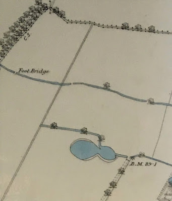
A map .....some ponds .... and a bit of the Longford Brook ……..

I am looking at one of my favourite maps of Chorlton-cum-Hardy.


It was produced for the Withington Local Board of Health in 1881, and I have Ricard Bond to thank for copying this section.

The Withington Local Board of Health was established following the Public Health Act of 1876, and covered the four townships of Burnage, Chorlton, Didsbury and Withington, and along with building the sewage works commissioned the map.

It is a beautifully detailed map and I have chosen the section which covers the area to the west of what is now the library stretching almost as far as the Longford Estate.

There is much to take in including the 27 properties that made up Fielden Terrace which was a community in itself, along with the Longford Brook, the Canal Feeder and the set of ponds some of which will have been the result of excavating marl and clay, a practice which went back to the 17th century.

These I have written about over the years and came back to recently.*


What I had never noticed before was the footbridge across the Longford Brook, which I guess vanished when this stretch went underground, leaving just a small section through Longford Park open to the sky. There are those who can remember when it was still there to see.  Equally another short bit in front of Copley Road was still exposed as late as 1934.

Just when most of it went underground is as yet unclear.  It was there in 1907 but had vanished by 1933.

And that is it.


"Although I copied the map, I also did not notice the footbridge until much later. As you say, this is a bridge over Longford Brook, not the canal feeder - the canal feeder is the watercourse running parallel to the Longford Brook, a little to the south, so OS have mis-labelled it. The section with the footbridge was culverted by the time OS surveyed a new map in 1892, see https://maps.nls.uk/view/126523724#zoom=5&lat=7759&lon=9124&layers=BT 

Note that the trees shown at top left are roughly where the present tree line of the eastern boundary of the disc golf course is located. The trees marked the then eastern boundary of the Longford estate but between 1876 and 1881, John Rylands and the Lloyd family exchanged lands, the result being the artificially straight boundary line running roughly N-S, to the east of the foot bridge. By 1892, Enriqueta Rylands had planted the present line of poplars, next to the boundary with Ryebank Fields, to mark the new boundary of her estate".

Location; Longford Road

Pictures; west of Martledge close to the Longford Estate, 1881 from the Withington Local Board of Health map, 1881,courtesy of Trafford Local Studies, and copied by Richard Bond

*Of clay pits ...... meandering streams …….. and plenty of ponds …… walking west of Martledge in 1854, https://chorltonhistory.blogspot.com/2021/11/of-clay-pits-meandering-streams-and.html


Wednesday, 21 August 2024

Martledge, that forgotten bit of Chorlton

As pictures go it is not the best quality but there is enough here to get a sense of this little bit of Chorlton.

The year is 1910 and we are just past the junction of Barlow Moor and Wilbraham Road.

This was once known as Martledge and until the 1870s was farm land with a few farmhouses, the old Royal Oak pub and block of houses known as Renshaw’s Buildings or just the New Buildings.

But during the 1880s this end of the township was developed pretty much as we know it today, with long lines of terraced and semi detached houses and parades of shops.

And this image captures this new Chorlton.  On the corner is the bank and beyond it is Renshaw’s Buildings which were a block of six two up two down houses or more likely twelve one up one downs.

They had been built sometime before 1832 by John Renshaw who lived on Beech Road.  He was a market gardener but diversified into property.

His block that you see was demolished to make way for the new Royal Oak and all that now survives of Renshaw’s Buildings is the kerb stone that runs at angles from Barlow Moor Road beside the pub.

Already by the beginning of the 20th century part of this old block had been turned into a cycle shop.

And just behind the wall of Renshaw’s was the entrance to the old Royal Oak which was more a beer shop than a pub and which dates from the 1830s.

Far away in the distance is the Temperance Hall and to our left parallel with the tram are a set of fine
Victorian houses which were demolished in the 1960s.

Picture; from the Lloyd Collection

Monday, 5 February 2024

Looking towards Oswald road ......another scene of lost Martledge from 1880


I have been visiting Martledge which has passed out of common knowledge, but was that part of Chorlton roughly from the four banks up to the Library.

Until the 1880s it was like most of the rest of our township a collection of cottages, farm buildings and open land.
 And in the summer and winter of 1882, Aaron Booth who lived at Sedge Lynn took a series of photographs of the area around his house.  This was Sedge Lynn and stood on the corner of Manchester Road and Nicholas Road.

He was a comfortably off business man who owned a packing business employing 7 men, and sometime after 1881 the family moved from Ardwick to Chorlton.  Only four of his photographs have survived but they are a rare insight into what Martledge was like.

Today I have chosen a picture he took from an upstairs backroom window looking out across what was called the Isles and is now the land stretching out along Oswald and Longford Roads to Stretford. In 1882 it was what it had always been, an open expanse of land dominated by ponds which had been dug out for marl for the fields and clay for house bricks.   The ponds were fed by little streams long since vanished.  Away to our left had been a row of cottages but the rest was just open land.

I rather think for any child it must have been a pretty wonderful place to roam, particularly on a warm summer’s day with little in the way of noise save the odd buzzing insects.  As a parent I might feel less happy.

There were I remember 17 ponds around what was Oswald Field where the cottages were and some were quite large and quiet deep.

Picture; from the Lloyd collection

Tuesday, 5 September 2023

When Withington stole a bit of Chorlton ....... today ... the story

 So tody you can discover the story of how Withington pinched a bit of Chorlton and how for almost a century people talked about the old and new villages.


Along the way there will be some rather dastardly individuals who engaged in murder, theft, and unruly behaviour, a thank you to Aaron Booth and the lost places of Martledge, Kemp’s Corner, and The Four Banks.

And at the centre of it all will be the day Withington stole Houghend from us, followed by the equally appalling disappearance of Martledge, with an investigation in to “All silk knickers and fancy cakes”.

The talk will be by Andrew Simpson ably assisted by Peter Topping and the magic lantern show begins at 1.30, today, Wilbraham St Ninian's Church Hall, Corner of Egerton Road South and Wilbraham Road, at 1.30pm and will last for about an hour, but by popular acclaim may go on a tad longer.

Admission £3 plus tea and coffee.

Another in the series of History talks at Chorlton Good Neigbours.

Pictures; Houghend, 2023, from the collection of Andrew Simpson, and Chorlton Park, 1934 from the OS map of Manchester & Salford, 1934

*Chorlton Good Neighbours, https://chorltongoodneighbours.org/


Monday, 4 September 2023

“All silk knickers and fancy cakes” …..and stories of grand theft .... tomorrow

 So tomorrow you can discover the story of how Withington pinched a bit of Chorlton and how for almost a century people talked about the old and new villages.

Houghend, 2023

Along the way there will be some rather dastardly individuals who engaged in murder, theft, and unruly behaviour, a thank you to Aaron Booth and the lost places of Martledge, Kemp’s Corner, and The Four Banks.

Wilbraham Road, circa 1890s
And at the centre of it all will be the day Withington stole Houghend from us, followed by the equally appalling disappearance of Martledge, with an investigation in to “All silk knickers and fancy cakes”.

The talk will be by Andrew Simpson ably assisted by Peter Topping and the magic lantern show begins at 1.30, tomorrow, Wilbraham St Ninian's Church Hall, Corner of Egerton Road South and Wilbraham Road, at 1.30pm and will last for about an hour, but by popular acclaim may go on a tad longer.

Admission £3 plus tea and coffee.

Another in the series of History talks at Chorlton Good Neigbours.

Location; Chorlton

Pictures; Houghend, 2023, from the collection of Andrew Simpson, and Wilbraham Road, circa 1890s

*Chorlton Good Neighbours, https://chorltongoodneighbours.org/


Sunday, 18 June 2023

Still in Martledge in 1910 with Red Gate Farm in the distance

Yesterday we were in Martledge around 1910 just beyond the junction of Barlow Moor and Wilbraham Road.

Today we have moved just a little further along and looking down towards Manchester Road with Red Gate Farm in the distance behind the tram.

Until quite recently Manchester Road was a continuous thoroughfare which crossed Wilbraham Road and by degree twisted and turned all the way to West Point.

But the development of the precinct and the building of the car park cut the road, and so while once it ran on beside Sedge Lynn and Barlow Moor Road past the farm which became the library now it is in two halves.

What I like about the image are the trees which front the houses on our right, all now vanished save for a few spindly ones on the kerb side.

And there also is what I think will be one of the orginal street lamps.

Picture; from the Lloyd Collection, circa 1910

Wednesday, 20 July 2022

The Titanic ……. Chorlton library …. a smelly stream and Mr Hastings ……… tales from the new book

 Today our new book, arrived from the printers. 

It is the second in the series “nothing to do in chorlton” and this one  is called "Martlege Lost and Found".

The first book has proved a runaway success, and so we been asked to repeat the format.*

The idea is that simple one where we choose six locations for you to sit, do nothing while we will tell stories of what went on at each of the six spots.

Tales which include the role of the Titanic in the history of Chorlton Library, a forgotten property developer, and the tale of a much-polluted stream, not forgetting a chunk of our lost industrial history as well as the magnificent Chorlton Ice Rink.

Like all our nothing books Martlege Lost and Found is divided into six short chapters which if you so choose can be “walked” with suitable stops to take in the views and the stories.

And to make it even easier we have made the book pocket size, selling it for the modest sum of £5, and is available from www.pubbooks.co.uk and Chorlton bookshop.

Arrived today
Location; from the former Four Banks, to the library and beyond

Picture; cover of nothing to do in chorlton, Martlege Lost and Found, 2022, and newly arrived today

The book, nothing to do in chorlton, Martlege Lost and Found by Andrew Simpson & Peter Topping, costs £5, is available from Chorlton Bookshop or us at  www.pubbooks.co.uk  

*nothing to do in chorlton, https://chorltonhistory.blogspot.com/search/label/A%20new%20book%20on%20doing%20nothing%20in%20Chorlton

Wednesday, 1 November 2017

“Martledge is reborn ...... or still lives on”

Now as regular readers to the blog will know I have been keen to resurrect Martledge which was the old name for that bit of Chorlton beyond the Four Banks.

Martledge, 2017
It disappeared as a name along with the fields, and farms of the housing boom which in just 25 years transformed the area.

So final was that change that the old name of Martledge was lost and in its place people called it New Chorlton of the new village to distinguish it from old Chorlton around the village green and up Beech Road.

Martledge, 1854
Not that we were immune to those name changes because Beech Road was for centuries called  Chorlton Row which might have confused a few people with hat other place with the same name in Chorlton on Medlock.

But at least someone has woken up to the old name of Martledge, sending Andy this addressed envelope which carried the title Chorlton-cum-Martledge.

And that was the story, until Andy owned up and told me he had given the name  Chorlton-cum-Martledge as his address to the company who saw no reason not to use it.

Ah well he had me for minute ........ still wouldn’t it be nice if it were true?

I might even start using Chorlton Row.

Location; Martledge,

Picture; address label, courtesy of Andy Robertson, and map of Martledge, 1854, courtesy of Digital Archives, http://www.digitalarchives.co.uk/ 

Monday, 16 September 2013

On Manchester Road in the summer of 1900 waiting to catch the horse drawn bus

Over the last few days we have been making our way through Martledge in the summer of 1910 and this is the final picture of the journey.

We are almost at the point where the road swings round to head north.

The parade of shops which was known as Hastings Buildings can be seen to the left behind the bus, and just out of sight on the left was Red Gate Farm now the site of the Library.

But we are a full ten years earlier than the other pictures and the clue is the horse drawn bus which was only withdrawn when the tram service was extended into Chorlton in 1907.

It is a wonderful period piece.

The houses all have fine hedges and high trees but those on the corner have long gone.

And on that sunny day possibly in 1900 the woman with the pram perfectly captures that mix of surprise and curiosity as the photographer sets about capturing the moment.

Only matched by the glances of the passengers on the bus who I suppose were no more expecting to be caught on camera.

There will be no one now who remembers these horse drawn buses which until 1901 were run by the Manchester Carriage Company.

In that year their operations were taken over by Manchester Corporation who moved fairly quickly to replace the horse with the tram.

On April 13 1903 a tram service from Bell Vue via Brook's Bar and Upper Chorlton Road was extended to West Point and four years later to Lane End.*

But the horse was to remain an important part of how people and goods were moved around the city for another few decades.

And just like there will be any one left who can realte their own experiences on the top deck of one of those horse drawn buses arriving by Red Gate Farm, I doubt that there will be many who also remember the houses on the corner.

All of which makes this a unique image of lost Chorlton.

*West Point is where Upper Chorlton Road, joins Seymour Grove and Manchester Road, Lane End was the junction between Sandy lane, Barlow Moor Road and High Lane.

Picture; from the Lloyd Collection