Showing posts with label Manchester Housing. Show all posts

Monday, 25 May 2026

Walking the mean streets of Manchester in the 1880s ………

Now, many of us will have been brought up with the stories of the appalling housing conditions in our cities, towns, and villages in the 19th century.

New gates, 1908
Just a few minute’s stroll from the imposing and elegant Georgian and Victorian government and commercial buildings were scenes of awful poverty, where the casual observer and interested researcher ventured with some trepidation.

The accounts of Dr. Kay, Frederick Engels and a heap of other writers are testimony to “how the other half lived”.

In the later 19th century surveys like that undertaken by Booth and Rowntree catalogued the poverty, and inequality in health, and housing provision.

To these can be added an excellent set of maps and notes on Manchester during the 1880s which like Booth and Rowntree’s work offer-coloured coded maps along with detailed descriptions which come from the reports of the officer of  Health for Manchester.*

I had come across some while researching at Central Ref a few years ago, but last week Craig Thomas offered up a link to a whole of set of digitized maps and reports.

They really are a cornucopia of wonderful things including a map of the Enumerator Districts for the city for 1871, which will make it easier for anyone wanting to locate a street.

44 Angel Meadow, 1900

And that pretty much is that I could say more, but what would be the fun of distracting you from looking for yourself.

That said there is a nice short Manchester Evening News report of how the maps were digitized.

Read more; Manchester Housing Conditions; https://chorltonhistory.blogspot.com/search/label/Manchester%20housing%20conditions

Location; Manchester

Pictures; Pictures; New gates, 1908, m8316, Angel Street, 1900, m85543, S.L.Coulthurst, courtesy of Manchester Libraries, Information and Archives, Manchester City Council, http://images.manchester.gov.uk/index.php?session=pass 

*Victorian Sanitary Survey Maps for Central Manchester, https://luna.manchester.ac.uk/ll/thumbnailView.html?startUrl=%2F%2Fluna.manchester.ac.uk%2Fluna%2Fservlet%2Fas%2Fsearch%3Fos%3D0%26lc%3Dmaps002~1~1%26q%3D%3D%22Project%3A%20Victorian%20Sanitary%20Survey%20Maps%20for%20central%20Manchester%22%26bs%3D100

**Forgotten maps of Manchester slums restored and available to view,  Nigel Barlow -April 3, 2019, https://aboutmanchester.co.uk/forgotten-maps-of-manchester-slums-restored-and-available-to-view/


Sunday, 18 January 2026

Lost stories in a forgotten street ……. the one behind Deansgate

Now it is easy to shudder and feel outrage at the accounts of housing conditions in the poor parts of Manchester in the first half of the 19th century.
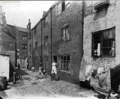
New Gates, Manchester,  1908
Overcrowding, back-to-back houses, closed courts where the sun fought to penetrate, and of course a lack of sanitation matched only by parts of the developing world are the stuff of social history.

But the history books and rarely the social observers of the time burrowed deep to offer up the personal stories of those who lived in the cellar dwellings and the one up one down properties, often built in the shadow of textile mills, and iron foundries and bounded by the polluted rivers that ran through the city.  

Dr Kay, Frederick Engels and a few foreign visitors did paint a grim picture.

And more revealing is the case notes of Dr Henry Gaulter who experienced the first outbreak of Cholera during the May to December of 1832. 

He kept a detailed record of the first three hundred patients he attended describing their physical condition, the onset of the disease and their living conditions but was forced to abandon the exercise as the numbers increased.*
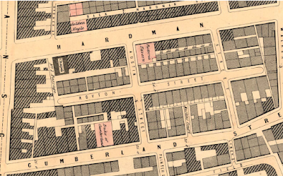
Royton Street, 1851
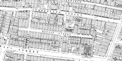
So, with that in mind I have plunged back into one street off Deansgate in 1851.  In that year it was home to 408 people who lived in 46 houses, nine of which were one roomed back-to-back properties, and the remainder, consisted of four rooms with weekly rents ranging from 1 shilling [5p] to 5s [25p].

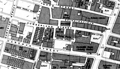
The street was Royton Street, and history has not been kind to it.  It never featured in any of the street directories for the 19th century, and progressively lost its houses and half its length to industrial development and finally vanished under the Spinnyfields project at the start of this century.

There are only two photographs of it in the City’s digital collection, and one of those I think has either been misplaced from somewhere else or is much older than the published date.**

I came across the place by chance a few days ago, wrote about it and planned to move on but the detail is as they say in the detail and so I trawled the 20 pages of the 1851 census and then went back for some of the surrounding closed courts.***

One bit of detail was the presence of a Catholic day and Sunday school in the middle of the street, which made perfect sense given that 36% of the street’s residents were born in Ireland and a cursory look at the surrounding area suggest that this was typical.
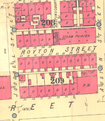
Royton Street, circa 1880-1900
Nor would the Irish accent be the only one you could hear, for while 50% were from Manchester, there were significant numbers of residents from Scotland, Wales, Yorkshire, as well other parts of Lancashire, seven from London, nine from Cheshire, and even one from Prussia.

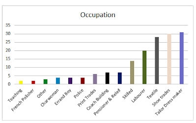
Their occupations were as varied as their origins, with a mix of textile workers, four policemen, an architect’s apprentice, and two teachers.

And there were the usual range of skilled trades from carpenters, painters, and glaziers to those engaged in the book and shoe trades, as well as tailors, dress makers, a blacksmith, oastler, and “brick setters.” 

But we are in one of the poorer areas of the city, and so here were labourers, house servants, and those on pensions, and poor relief.

To which we can add children, for over a third of the street were young people under the age of 15, and while plenty of these were attending school others by the age of 11, were employed as errand boys, apprentices, and servants.
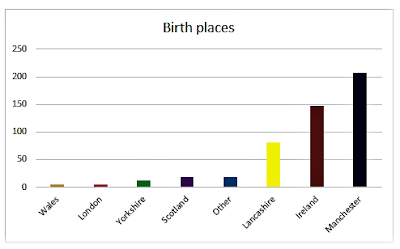
Birth places of Royton Street residents, 1851
The census also records the degree of overcrowding, so our 408 inhabitants lived in just 46 houses made up of 89 households.  

Nor does this deliver the true degree of overcrowding.  So picking just three houses, which were numbers one, three, and four, together they were home to 38 people.  

At number one there were 18, divided into three households, at number three, eight divided into two households, and at number four there were 12 living in three households.

It is a picture replicated across the entire street, and while there were some big families, there were also many lodgers.  In total the figure was 72, most of whom were unmarried, were not related, and were occupied in a variety of skilled and non-skilled occupations.  

Of the 72, only 11% were from Manchester, with the rest drawn from all parts of the country, with 43% from Ireland.
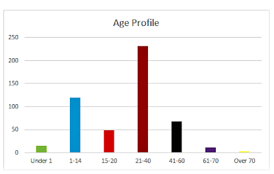
Age Profile of Royton Street residents, 1851

Almost every household included some lodgers, and while there were a few “lodging houses” most families shared their home with people they were unrelated to.

All of which raises the question of how big the houses were.  

There were 14 back to back properties which might have had three rooms but equally might have had just two, and the census return is silent on the total number of rooms for these or the remaining houses.  

The surviving properties listed in 1901 indicate that they consisted of four rooms, but by then there were only 14 left which leaves the other 32 a mystery.
Royton Street, 1849
Nor it appears were there any cellars, recorded on the 1851 census.  Now cellar dwellings do show up for other parts of the city, and people are recorded as living in them, so it seems Royton Street was cellar free, or at least, from cellar occupants.

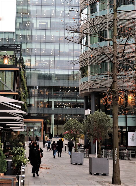
For the curious Royton Street was located between Hardman and Cumberland Streets and its course roughly follows the route of the Avenue in Spinneyfields
In the vicinity of Royton Street, Spinningfields, 2020

Occupations of Royton Street residents, 1851
Next, I have a fancy to explore some of the families and try to delve into what their lives were like.

Location; Off Deansgate, Manchester

Pictures; New Gates, 1908, m8316,  courtesy of Manchester Libraries, Information and Archives, Manchester City Council, http://images.manchester.gov.uk/index.php?session=pass, Spinneyfields, 2020, from  the collection of Andrew Simpson and Royton Street in 1849, from the OS map of Manchester and Salford, 1844-49, and Royton Street circa 1880-1900 from Goad's Fire Insurance maps, courtesy of Digital Archives, http://digitalarchives.co.uk/and Royton Street 1951, from the OS map of Manchester and Salford
All that was left, 1951

*Gaultier Henry, The Origin and Progress of the Malignant Cholera, 1833, London, & Appendix A, To the Report of the General Board of Health on the Epidemic Cholera of 1848 & 1849, 1850, London

**Royton Street, Manchester Libraries, Information and Archives, Manchester City, http://images.manchester.gov.uk/index.php?session=pass

***Lost and forgotten streets of Manchester .......... nu 95 Royton Street, 1951 https://chorltonhistory.blogspot.com/2022/02/lost-and-forgotten-streets-of.html 

Tuesday, 18 March 2025

On discovering Ainsworth Court …… a bit of that very ….. very old Manchester

Today I found Ainsworth Court which was off Long Millgate in the heart of the older part of Manchester.

Ainsworth Court, 1851
I can’t claim it is an earth-shattering discovery, but it was part of that twisty turny area of the city which was almost closed off to the rest of the world.

It was one of those closed courts where a collection of buildings looked out on an open space.  To its rear was the River Irk and it was accessed through a narrow entry.

I suppose its only real claim to fame was that for a few short years it was a Jewish place of worship, from around 1810 till the Halliwell Synagogue was opened fifteen years later.

Other than that, I have so far located a only few people who lived there in the 1850s and 60s.

In 1863 the rate books list four resident who variously described themselves as a bookkeeper, cabinet maker, machine broker and householder, and census returns suggest that most of the properties were occupied by just two or three people.  

Which is all to the good given that the same rate books record modest rents which I suspect means that the properties were small.

The Court was built sometime around 1794 and had vanished by 1894.

No pictures exist and the best I can offer are the houses on Long Millgate directly in front of the court.

The date is 1875 and it appears to show the entry from Long Millgate into the court.

Long Millgate, 1875

That same picture nicely locates the court to a spot beside what was then Cheetham’s Hospital School and the gate house is clearly visible.

Just exactly when the Court vanished is unclear but successive maps show different buildings of which the most recent is and extension to the Music School built in 2012.

It isn’t the stuff of great events but it is a bit little history, that record of the past which is all about vanished places and forgotten people.

So, I shall close with Francis Brewer who was the bookkeeper, John Whittaker the cabinet maker, George Schofield the machine broker and John Brewer the householder.

Two years earlier most of them were in the court with families and George Schofield was in residence from the 1860s through to 1871.

More to follow.

Location, Long Millgate

Pictures, Long Millgate, 1875, m79431, courtesy of Manchester Libraries, Information and Archives, Manchester City Council, http://images.manchester.gov.uk/index.php?session=pass and Ainsworth Court, 1851 from Adshead’s map of Manchester, Digital Archives Association, http://www.digitalarchives.co.uk/ 


Saturday, 19 February 2022

Ghost streets …….. and the onward march of the cranes

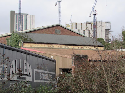
Now it seems everywhere you look there are those cranes which relentlessly march across the city, leaving in their wake a mix of tall residential and commercial towers.

The onward march of the cranes, Travis Street, 2022
You encounter them on the main roads into the city, west into Salford, all over the Northern Quarter and now in ever larger numbers in the shadow of Piccadilly Railway Station.

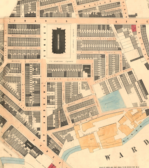
And it is of that area around Fairfield Street, north towards Travis Street and the site of St Andrew’s Church, and south beyond the great railway viaducts that I want to write about.

But before anyone leaps to their keyboard to call down wrath on the cranes and the developers, historically this is but a new round of urbanization which had already covered the area with narrow streets, mean houses and a variety of industrial units from mills to foundries, and dyeworks, interspersed with timber yards.

My copy of Adshead’s map of Manchester from 1851 clearly shows the degree to which 19th century speculative builders had created a densely packed network of streets and courts, which nestled beside those factories and hemmed in by railway lines, canals and the river.

From the river to the Square, 1851

For over four decades I have been fascinated by their history and keep coming back to the stories of the houses and the people who lived there. *

Of course, they have all gone, swept away by a mixture of municipal house clearances over two centuries, further helped by Mr. Hitler’s bombs, along with the grand plans of the railway companies which cut a swathe through those streets with their giant railway viaducts.

To which we can add the deindustrialization of the centre of Manchester which saw the mills, dyeworks and foundries close to be replaced by small businesses, car parks and open spaces.

But with a bit of imagination and armed with old maps of the area it is possible to gain a sense of just how many houses existed because much of the street plan still exists.

When the old jostles with the new, 2022
So there are still a heap of tiny narrow streets branching off Fairfield Street,  St Andrews’ Square and Travis Street.  

They may have lost their buildings but the sheer number of them brings home the density of the area.

So there is the challenge, all you have to do is wander past Piccadilly Railway Station and plunge eastwards, but do so soon, because within a few years the cranes will have done their job.

Location; east of Piccadilly Railway Station

Pictures; between Travis Street and Fairfield Street, 2022, from the collection of Andy Robertson, and in 1851, 1851 from Adshead map of Manchester, 1851, courtesy of Digital Archives Association, http://digitalarchives.co.uk/

*Fairfield Street, https://chorltonhistory.blogspot.com/search/label/Fairfield%20Street

Homer Street, https://chorltonhistory.blogspot.com/search/label/Homer%20Street

St Andrew’s Square, https://chorltonhistory.blogspot.com/search/label/St%20Andrew%27s%20Square


Wednesday, 7 July 2021

One hundred years of one house in Chorlton …. part 122 ....... Totò Looks For A House

The continuing story of the house Joe and Mary Ann Scott lived in for over 50 years and the families that have lived here since. *


Now I doubt that Joe and Mary Ann watched Italian films, but yesterday was Totò night in the house.

Rosa had arrived over from Milan on Friday, and we had bought in several films by Totò, who like Rosa was from Naples.

He is someone I have written about before, and over the years I have become quite a fan.**

Last night we chose Totò Cerca Casa, or Totò Looks For A House, which was made in 1949 and was the second most popular film of the year.

The sets were pretty basic, the humour fairly slapstick and some at least of the actors might have been better enrolling in acting school, but given all of that it was funny.

And while the plot was at best fairly implausible it did hold some truths.

Like most of post war Europe there was a severe housing shortage and Totò and his family end up in a number of different properties, each more unsuitable than the one before, including a school, a cemetery caretaker's house, the studio of an artist, a large luxury apartment and even the Colosseum before ending up in a psychiatric hospital.


Each location offers up comic possibilities, from a student rebellion led by Totò, to an apparent ghost at the cemetery, and the discovery that the luxury apartment has also been rented out to another family at the same time. 

Behind the humour of course is the very real hardship of people with no where to live.  

Naples was already a hard city to live in and the war made it harder.

Here in Britain there was the same lack of properties, which in turn led to the squatter movement was a direct response tin part to the shortage of accommodation because of war damage but also because some properties had been deliberately left unoccupied by their owners.

The campaign was nationwide and in London was coordinated by the Communist Party.

Here in Manchester the first successful squat was at the gun site near Alexandra Park which housed one family at 8 p.m., but by the following day contained a community of over 20 families and all available huts were occupied. It is a fascinating story and ended with the Corporation accepting the squatters as tenants.*** 


Joe and Mary Ann will I suspect have known about the Alexandra Park squat, and taken a keen interest given that they built decent and affordable houses across Chorlton.


But I have no idea whether they would have enjoyed Totò Cerca Casa or the selection of foods Rosa cooked up that evening, which included peppers, a selection of greens in olive oil and may favourite, a salad made from oranges and dressed with garlic, olive l and chillies.

 Pictures, Totò Cerca Casa, 1949 and a selection of Neapolitan dishes.

*The story of a house, https://chorltonhistory.blogspot.co.uk/search/label/The%20story%20of%20a%20house

Walking the streets of Naples with a comic genius ........ Totò, https://chorltonhistory.blogspot.com/2020/01/walking-streets-of-naples-with-comic.html

Totò 

***The forgotten story ………. a little bit of squatter history in Alexandra Park, https://chorltonhistory.blogspot.com/2020/07/the-forgotten-story-little-bit-of.html