Showing posts with label Manchester housing conditions. Show all posts

Tuesday, 18 March 2025

On discovering Ainsworth Court …… a bit of that very ….. very old Manchester

Today I found Ainsworth Court which was off Long Millgate in the heart of the older part of Manchester.

Ainsworth Court, 1851
I can’t claim it is an earth-shattering discovery, but it was part of that twisty turny area of the city which was almost closed off to the rest of the world.

It was one of those closed courts where a collection of buildings looked out on an open space.  To its rear was the River Irk and it was accessed through a narrow entry.

I suppose its only real claim to fame was that for a few short years it was a Jewish place of worship, from around 1810 till the Halliwell Synagogue was opened fifteen years later.

Other than that, I have so far located a only few people who lived there in the 1850s and 60s.

In 1863 the rate books list four resident who variously described themselves as a bookkeeper, cabinet maker, machine broker and householder, and census returns suggest that most of the properties were occupied by just two or three people.  

Which is all to the good given that the same rate books record modest rents which I suspect means that the properties were small.

The Court was built sometime around 1794 and had vanished by 1894.

No pictures exist and the best I can offer are the houses on Long Millgate directly in front of the court.

The date is 1875 and it appears to show the entry from Long Millgate into the court.

Long Millgate, 1875

That same picture nicely locates the court to a spot beside what was then Cheetham’s Hospital School and the gate house is clearly visible.

Just exactly when the Court vanished is unclear but successive maps show different buildings of which the most recent is and extension to the Music School built in 2012.

It isn’t the stuff of great events but it is a bit little history, that record of the past which is all about vanished places and forgotten people.

So, I shall close with Francis Brewer who was the bookkeeper, John Whittaker the cabinet maker, George Schofield the machine broker and John Brewer the householder.

Two years earlier most od them were in the court with families and George Schofield was in residence from the 1860s through to 1871.

More to follow.

Location, Long Millgate

Pictures, Long Millgate, 1875, m79431, courtesy of Manchester Libraries, Information and Archives, Manchester City Council, http://images.manchester.gov.uk/index.php?session=pass and Ainsworth Court, 1851 from Adshead’s map of Manchester, Digital Archives Association, http://www.digitalarchives.co.uk/ 


Monday, 18 November 2024

Walking the streets of Manchester in 1870 ......... of privies closed courts and foul passages..... Ludgate Street

Now Ludgate Street which runs from Rochdale Road into Angel Meadow should have fared better.

New gates, 1908, a closed court
There are no images of the place in the City collection, it warrants only one entry in a street directory and got a pretty poor press from the Manchester Guardian back in 1870.

You can still walk down it today.  It is one of the narrower streets in the city and is fronted by a mix of tall residential properties, and until recently was home to a warehouse, car park, and some open land.

And as such is not over remarkable but back in 1870 it attracted the attention of the Manchester Guardian and appeared as No. 3 of their series “In the Slums.”*

Ludgate Street, 1851
“Ludgate-street is a principal thoroughfare leading from Rochdale Road into Angel Meadow.

From each side of this street branch off many courts, each with its open gutter down the centre; and as the houses are built back to back, forming the front street and back yard at the same time.

In each of these courts we find privies and ashpits very dilapidated and dirty, and in many cases built over with rooms.

In Church court the privies open on to the yard or court, where boys and girls are playing about. ....... Foul passages past fouler places lead from these courts and streets, passages so narrow that it is impossible to avoid contact with that which decency would shun, but which is utterly unheeded by those who dwell here, such is the debasing effect of constantly living in such places.

Back Simpson –street, Marshall’s Court and many other places we have visited could be adduced to show how horrible this district is, but it is needless to reiterate facts.  In Factory Court there is one lodging-house registered for 20 beds. And 20 beds means 40 persons and for these 40 persons there are one privy and one ashpit, and these are partially destroyed by the fall of an adjacent wall.

Church Court off Ludgate Street, 1851
In Joinery-street there is a court with a foul privy, without a door, and full ashpit within five feet of the living room; and in a court off Brabham-street one privy, without a seat or door and in such a state that it cannot be approached, is the sole provision for seven houses.”

Nor was that quite all, because our intrepid journalist moved a little distance away to Newtown which he described as a suburb of Angel Meadow which had “plenty of open spaces, spaces which might act as lungs for the overcrowded district it adjoins and where a little fresh air might be found.”

Nearby in another building were “hundreds of cows’ feet waiting to be boiled and, and separated from them by a board only, a heap of bones of those which have preceded them."

44 Angel Street 1898 which backed on to Ludgate Street
Alas this was not to be because the area was full of piggeries.

Behind one street there were sixteen in a long block “without drainage or anything to carry away the filth; it soaks through and runs the amongst the soil till the place is offensive in the extreme for yards away."

Now I could go on but I won’t.  There were plenty of more pleasant places in the city which in the fullness of time will appear in our walks but for now that is it.

Next time; Deansgate and Davenport’s Court “where “scarcely a night passes but some robbery id committed ........ and almost under the shadow of the Cathedral tower.”

Location; Manchester in 1870

Pictures; New gates, 1908, m8316, Angel Street, 1900, m85543, S.L.Coulthurst, courtesy of Manchester Libraries, Information and Archives, Manchester City Council, http://images.manchester.gov.uk/index.php?session=pass and Ludgate Street in 1851 from Adshead map of Manchester, 1851, courtesy of Digital Archives Asscociation, http://digitalarchives.co.uk/

*In the Slums, Manchester Guardian, March 3, 1870

Wednesday, 16 October 2024

Lost stories in a forgotten street ……. the one behind Deansgate

Now it is easy to shudder and feel outrage at the accounts of housing conditions in the poor parts of Manchester in the first half of the 19th century.

New Gates, Manchester,  1908
Overcrowding, back-to-back houses, closed courts where the sun fought to penetrate, and of course a lack of sanitation matched only by parts of the developing world are the stuff of social history.

But the history books and rarely the social observers of the time burrowed deep to offer up the personal stories of those who lived in the cellar dwellings and the one up one down properties, often built in the shadow of textile mills, and iron foundries and bounded by the polluted rivers that ran through the city.  

Dr Kay, Frederick Engels and a few foreign visitors did paint a grim picture.

And more revealing is the case notes of Dr Henry Gaulter who experienced the first outbreak of Cholera during the May to December of 1832. 

He kept a detailed record of the first three hundred patients he attended describing their physical condition, the onset of the disease and their living conditions but was forced to abandon the exercise as the numbers increased.*
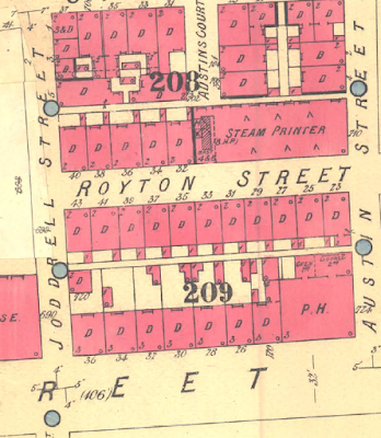
Royton Street, 1851
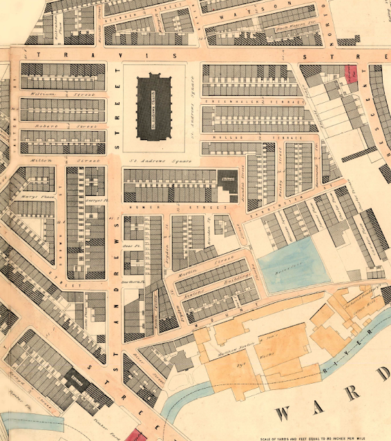
So, with that in mind I have plunged back into one street off Deansgate in 1851.  In that year it was home to 408 people who lived in 46 houses, nine of which were one roomed back-to-back properties, and the remainder, consisted of four rooms with weekly rents ranging from 1 shilling [5p] to 5s [25p].

The street was Royton Street, and history has not been kind to it.  It never featured in any of the street directories for the 19th century, and progressively lost its houses and half its length to industrial development and finally vanished under the Spinnyfields project at the start of this century.

There are only two photographs of it in the City’s digital collection, and one of those I think has either been misplaced from somewhere else or is much older than the published date.**

I came across the place by chance a few days ago, wrote about it and planned to move on but the detail is as they say in the detail and so I trawled the 20 pages of the 1851 census and then went back for some of the surrounding closed courts.***

One bit of detail was the presence of a Catholic day and Sunday school in the middle of the street, which made perfect sense given that 36% of the street’s residents were born in Ireland and a cursory look at the surrounding area suggest that this was typical.

Royton Street, circa 1880-1900
Nor would the Irish accent be the only one you could hear, for while 50% were from Manchester, there were significant numbers of residents from Scotland, Wales, Yorkshire, as well other parts of Lancashire, seven from London, nine from Cheshire, and even one from Prussia.

Their occupations were as varied as their origins, with a mix of textile workers, four policemen, an architect’s apprentice, and two teachers.

And there were the usual range of skilled trades from carpenters, painters, and glaziers to those engaged in the book and shoe trades, as well as tailors, dress makers, a blacksmith, oastler, and “brick setters.” 

But we are in one of the poorer areas of the city, and so here were labourers, house servants, and those on pensions, and poor relief.

To which we can add children, for over a third of the street were young people under the age of 15, and while plenty of these were attending school others by the age of 11, were employed as errand boys, apprentices, and servants.

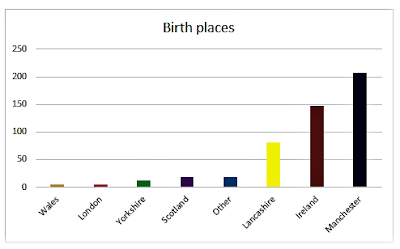
Birth places of Royton Street residents, 1851
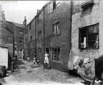
The census also records the degree of overcrowding, so our 408 inhabitants lived in just 46 houses made up of 89 households.  

Nor does this deliver the true degree of overcrowding.  So picking just three houses, which were numbers one, three, and four, together they were home to 38 people.  

At number one there were 18, divided into three households, at number three, eight divided into two households, and at number four there were 12 living in three households.

It is a picture replicated across the entire street, and while there were some big families, there were also many lodgers.  In total the figure was 72, most of whom were unmarried, were not related, and were occupied in a variety of skilled and non-skilled occupations.  

Of the 72, only 11% were from Manchester, with the rest drawn from all parts of the country, with 43% from Ireland.

Age Profile of Royton Street residents, 1851

Almost every household included some lodgers, and while there were a few “lodging houses” most families shared their home with people they were unrelated to.

All of which raises the question of how big the houses were.  

There were 14 back to back properties which might have had three rooms but equally might have had just two, and the census return is silent on the total number of rooms for these or the remaining houses.  

The surviving properties listed in 1901 indicate that they consisted of four rooms, but by then there were only 14 left which leaves the other 32 a mystery.

Royton Street, 1849
Nor it appears were there any cellars, recorded on the 1851 census.  Now cellar dwellings do show up for other parts of the city, and people are recorded as living in them, so it seems Royton Street was cellar free, or at least, from cellar occupants.

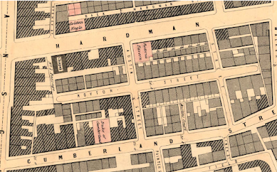
For the curious Royton Street was located between Hardman and Cumberland Streets and its course roughly follows the route of the Avenue in Spinneyfields

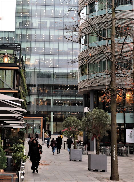
In the vicinity of Royton Street, Spinningfields, 2020

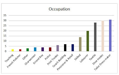
Occupations of Royton Street residents, 1851
Next, I have a fancy to explore some of the families and try to delve into what their lives were like.

Location; Off Deansgate, Manchester

Pictures; New Gates, 1908, m8316,  courtesy of Manchester Libraries, Information and Archives, Manchester City Council, http://images.manchester.gov.uk/index.php?session=pass, Spinneyfields, 2020, from  the collection of Andrew Simpson and Royton Street in 1849, from the OS map of Manchester and Salford, 1844-49, and Royton Street circa 1880-1900 from Goad's Fire Insurance maps, courtesy of Digital Archives, http://digitalarchives.co.uk/and Royton Street 1951, from the OS map of Manchester and Salford

All that was left, 1951

*Gaultier Henry, The Origin and Progress of the Malignant Cholera, 1833, London, & Appendix A, To the Report of the General Board of Health on the Epidemic Cholera of 1848 & 1849, 1850, London

**Royton Street, Manchester Libraries, Information and Archives, Manchester City, http://images.manchester.gov.uk/index.php?session=pass

***Lost and forgotten streets of Manchester .......... nu 95 Royton Street, 1951 https://chorltonhistory.blogspot.com/2022/02/lost-and-forgotten-streets-of.html 

Friday, 24 May 2024

Living in a two roomed cottage in a Manchester court in 1851


You won’t find Span Court I know I tried.  But I do know where it was and where it had been when it was home to hundreds of families from about 1780 till sometime after 1965.

It was one of those bits of infill, the product of speculative builders trying to squeeze as many houses as possible onto a small piece of land.  In this case the plot was off Artillery Street which runs from Byrom Street to Longworth Street behind Deansgate.  Courts like these might hold half a dozen houses which faced each other across an open paved area and in some cases were locked away behind other properties, with access down narrow alleyways.

Many were back to back houses consisting of just two rooms, made from poor quality materials with party walls which were just half a brick thick and floors laid directly onto the bare earth.
My great grandmother grew up in just such a property in Whiteman’s Yard and those in Span Court were little different.  True they had cellars which still in the middle of the 19th century might be occupied by families, but otherwise they resembled the one she was born in.

In 1844 Manchester stopped the building of new houses which did not have running water and a toilet in the house or the yard which meant that no back to back houses or courts were built, although in neighbouring Bradford and Openshaw such properties continued to be constructed.  By 1900 there were only 5,000 back to backs left in the city and these had all been removed or converted  to ‘through’ houses by 1939.*

Span Court consisted of six such properties.  The eastern side of the court backed on to three identical houses fronting Swan Court while the western three were set up against industrial buildings which later became a hospital.

And in those six houses in 1851 lived a total of thirty-three people who made their living from the bottom end of economic pile.  And so while there were 6 power loom weavers and a cooper and dress maker there were also an errand boy, a hawker and one who described himself as a pauper.
Now over the next few weeks I will be delving deeper into Spam Court and trying to tell its story, looking at the people who lived there and the surrounding streets.

*Parkinson-Bailey, John P, Manchester University Press, 2000

Pictures; Span Court in 1965 J. Ryder, m00211, Courtesy of Manchester Libraries, Information and Archives, Manchester City Council, Span Court from the 1842-44 OS map of Manchester & Salford, courtesy of Digital Archives, http://www.digitalarchives.co.uk/ and Artillery Street looking up from Byrom Street with Span Court off to the right,  from the collection of Andrew Simpson

Tuesday, 28 February 2023

What a difference a street makes ... contrasts in wealth and poverty


Today we are on a journey.  It is a short one in terms of distance just the space between two streets, but in almost every other sense it is a huge one.  

I want to walk from Span Court to St John Street and I have chosen 1851 as our point in time.  Spam Court was a collection of six back to back houses in a partially enclosed court off Artillery Street which runs from Byrom Street to Longworth Street behind Deansgate and I have written about them already.

They were one up one down with a cellar and did not rate an entry in the street directories which is not unsurprising given that those who lived here were on very modest means and some on the very margins of poverty.

In 1851 in those six houses lived a total of thirty-three people who made their living from the bottom end of the economic pile including six power loom weavers, a cooper, dress maker as well as an errand boy, a hawker and a pauper. More over in all but one of the six there were two families, one of which may have lived in the cellar or in one of the two rooms.  These were small houses, and the rooms may have been no more than 3.5 m square.

There would have been little in the way of furniture and the only natural light came from single windows that looked out on the narrow court.  They were not the worst of accommodation that the city had to offer and were perhaps slightly better than what could be found in the countryside but they were pretty basic.  Even in 1965 when the properties had been enlarged by extending back into the houses behind to make four rooms, living here would not have been my choice.

And as if to underline just how basic they were their yard was overlooked by the fine homes of St John’s Street, and it is to that place we shall go next.  Here in very grand houses lived accountants, a silk manufacturer and a retired calico engraver and printer.

The latter was John Holt whose father had made his wealth from making the engraving blocks used for calico printing and had eventually retired to a large estate in Chorlton.   John Holt would follow him sometime soon after 1851 but the family retained their interest in the area.*

Their home was the finest.  It is the only double fronted one on the street and had a huge and impressive bay window at the rear which extended over two floors.  Even today when the property has been turned into consulting rooms something of the style, comfort and good living is apparent. John and Sarah Holt lived here with their four children mother in law and two servants spread out over three floors.

But that fine bay window would have allowed them to gaze out on plenty more mean and basic cottages, for behind them were three small courts all with their own back to back properties which ran out on to Camp Street.

If the Holt’s however found this a little disconcerting they could console themselves with the thought that they owned all 24 of them.

In the midst of wealth there was indeed poverty but it was a profitable poverty for some.

Pictures; Span Court, J. Ryder, 1965 m00211, Courtesy of Manchester Libraries, Information and Archives, Manchester City Council,  detail from the 1842-44 OS map of Manchester & Salford, Digital Archives, http://www.digitalarchives.co.uk/ photographs of 11 St John Street from the collection of Andrew Simpson


*Camp Street, Holt Place, James Place, Longworth Street, Severn Street, Byrom Street, Great John Street, Gillow Street, Lower Byrom Street, Charles Street, Peel Street and City Road

Sunday, 15 January 2023

Trying to find the lives of the people behind the doors on Angel Street

Now tracking down the residents of some common lodging houses in the seedier part of Manchester in the late 19th century was never going to be easy.

But as part of the story of the people behind the doors of Angel Street it was something I wanted to do, if only to give these long lost people some substance.

After all living in a common lodging house and sharing a room if not a bed with a group of strangers marks you out as at the bottom of the pile and the chances are you will leave little of anything behind.

So in I wanted to piece together their lives before they arrived in Angel Street in 1901.

Some had been married and will have run a family home, others might have always been on the move from one temporary accommodation to another, but the census returns would at least anchor them somewhere every ten years before 1901.

And it would throw light on their occupations helping determine whether they had always been in jobs which were low paid, casual and uncertain.

There were 112 to choose from and not being a statistician I went for ten to begin with.  These included the young Matilda Walker aged 23, a single mother of two who gave her occupation as charwoman, a number of middle aged men and women from Manchester and two elderly men born in Ireland.

To make it easier to track the women I went for those who said they were single and pretty much split the men between those who were married and those who were unmarried.

Now any one who has searched for family relatives will know that crawling over the official records can lead to countless alternatives and a lot of dead ends.

And so it has been with my ten.  In some cases a census return would yield up a clue only to be marginalised when three other likely candidates offered themselves up.

Worse still many just didn’t appear at all.  They seem to have evaded the enumerator on census day, were not baptised and passed away leaving not even a death certificate.

Of course they will be somewhere but as yet not where I can find them.

I rather think some will have gone under different names, perhaps others left the country or were just never at the right place to be caught on an official document.

Matilda who was born in Salford may be the daughter of John and Matilda who were living at 33 Back Hampson Street in Greengate in 1891.

She is the only one roughly of the right age to show up on a census return, but I can’t find her for a decade before and likewise I lose her after 1901.

Nor have her children fared any better.  Sarah had been born in 1897 and John in 1901.  Of John there is not even a birth record and for his sister a choice of two 14 year olds who in 1911 were working as domestic servants, one in Surrey and the other around the corner from Angel Street.

Of the other nine there were a few false dawns and more dead ends.

Not that I shall stop.  The exercise remains a valid one and so I travel in hope.

Picture; Angel Street, 1900, Samuel L Coulthurst, m08978, courtesy of Manchester Libraries, Information and Archives, Manchester City Council, http://images.manchester.gov.uk/index.php?session=pass

Tuesday, 20 September 2022

Behind the door of 44 Angel Street revealing stories of the "common lodging houses"

Angel Street in 1901
I am back on Angel Street between 1897 and 1901.

Recently  I wandered down the street in the company of Samuel L Coulthurst who took a series of pictures of the people and their homes including one rare shot of the inside of number 44.

And today I am back having spent my time crawling over the census return for the same street in 1901.

The pictures reveal a row of late 18th and early 19th century houses similar to those which were going up across the city in the boom years as Manchester quickly became “the shock city of the Industrial Revolution”*

The south eastern side from what is now Rochdale Road up to St Michaels’s Fields had been built in 1794 and those we can see in the pictures were there by 1819**

What makes Coulthurst’s pictures all the remarkable is that having identified the houses it is possible to discover who was living in them just a few years later.

On Angel Street in 1898
Now I would love to be able to record who exactly was living at number 44 when in the May of 1897 Samuel took his pictures, but I can’t.

 The best I can do is identify who was there on the night of March 31st 1901 when the census was taken.

There were thirty two of them all male ranging from William Paxton aged 22 from Wigan who described himself as a street hawker to Thomas Reed from Ireland who at 74 was still working as a labourer.

All  them earned their living from manual work or the slightly more precarious occupation of selling on the streets.

Most were single although a few were widowers and while the largest single group had been born here there were those from the rest of Lancashire, as well as Ireland Scotland and even London.

I try not to be sentimental but you cannot help feeling a degree of sadness that so many of these men well past middle age were living crammed together in a common lodging house with nothing but a few possessions and the knowledge that with old age, sickness or just bad luck the future might be the Workhouse.

History of course has been unkind to them and most will have few records to stand as witness to their lives and so during the course of the next few weeks I want to track some of them and discover what their lives had been like.

Outside 44 Angel Street in  May of 1897
In the process I think we will uncover something of that shifting population at the bottom of the income pile and the extent to which they went from one overcrowded property to another.

Sadly the identities of those staring back at us are lost and so who they were and what happened to them cannot be revealed.

But that is not completely the case, because I think standing outside number 44 with his flat cap and parcel under his arm might just be Patrick Comer whose name appears above the door and who fourteen years later is still registered at the address on the street directory.

Patrick Comer
If this is him he seems to have had a varied life.  Born in Manchester sometime around 1850 he was variously a dyer, a joiner and in 1911 was both listed a step ladder maker and a clothes agent.

He never strayed far from Angel Street and can be found on Mount Street which runs into Angel Street and on Rochdale Road close by.

As for the others they are unknown and I doubt would still have been living at number 44 by 1901.

The very nature of these lodging houses meant that the residents were short term stay but we shall see.

Most of Angel Street also consisted of lodging houses and as I trawl the census return they reveal a rich cross section of those at the margins of late 19th century Manchester life.

And they point to number 44 being a tad unusual in that it was entirely male orientated.  The other lodging houses had more of a mix of men and women, married as well as single and some unmarried women with young children who defiantly refused to describe themselves as either married or widowed.

Inside number 44 Angel Street, 1897
It will indeed be a fascinating exploration of this part of the city.

Now that should be the end but there is just one last discovery, for I have tracked Mr Samuel L Coulhurst.

He was a book buyer from Salford, born in 1868 and living at number 4 Tootal Road Pendelton and in the fullness of time I think he also deserves a closer look.

Location, Angel Meadow, Manchester

Pictures; Angel Street, 1900, m85543 44 Angel Street, 1897, m08360, 44 Angel Street 1898, m00195, and Angel Street common lodging house, 1897, m08365, S.L.Coulthurst, courtesy of Manchester Libraries, Information and Archives, Manchester City Council, http://images.manchester.gov.uk/index.php?session=pass


**Asa Briggs, Victorian Cities, 1963

**The south east side of Angel Street are missing from Laurent’s map of Manchester in 1793 but are there the following year on Green’s map while the side photographed by Coulthurst show up on Johnson’s map of 1819.


Saturday, 26 February 2022

On Angel Street with the "common lodging houses" in 1900

On Angel Street in 1900
We are on Angel Street in 1900.

Now I can’t be exactly sure where along Angel Street we are  but I think it will be around the middle and it is just possible we are looking down from St Michael’s Fields  towards Rochdale Road.

The Street still exists today and there is still a pub at what would have been number 6, on the corner with Dyche Street.

Back then it was the Weavers Arms although now it goes under the name of The Angel Pub which  I guess will have been an inspired piece of thinking by someone attempting to re brand the place.

In time I will go looking for how long there has been a pub on this site and when it may have changed its name.

I suspect it may have had some lean years given that until recently there was little in the way of anything on any of the surrounding streets.

But now new build has gone up off Angel Street and a little further down are the new Co-op offices.

That said Angel Street is just a shadow of its former self.

But back in 1900 it was alive with houses, businesses and a cotton mill.

Now I knew I would never be able to identify the woman in the picture sitting on the steps, but I am became curious about her and where she lived.

So as you do I hunted down the street directories and census returns.
I was expecting the usual mix of small terraced properties sandwiched between factories timber yards and engineering works.

What I found were lodging houses, not one but lots of them.

I counted nine on a street which listed only eleven properties but these numbers hid a more interesting discovery that many of these lodging houses were collections of individual house which had become larger units.

So number 9 Angel Street also included numbers 11 and 13, and this was replicated all along.

Here then was one of those places given over to cheap accommodation where the residents were crammed in.

In nu 44 Angel Street, a "common lodging house"
And there was a uniformity here, men and women of all ages mostly at the lower end of the income range and from across the country and over the sea.

At number 44 there were 32 people staying and by one of those odd strokes of luck just four years earlier a Mr Coulthurst had wandered down Angel Street with his camera capturing our woman on the steps and even more remarkably taking a picture of an upstairs room at number 44.

Now four years is a long time in the life of a rundown lodging house just off Angel Meadow but it could just be that some of the 32 men  sleeping there on the night of the census in 1901 might have been in 1897.

Most were either single or widowed but there were some married couples.

Theirs were the jobs that paid little, and were as uncertain as any.  So amongst the 32 were Thomas Reed, 74 from Ireland who gave his occupation as "hawker" and Frederick Mason a labourer from Scotland aged 34.

And there are plenty more which leads me to think that here there is a real opportunity to wander across the census returns and try to track some of these people across the city and across occupations.

Now that should be a fascinating journey.

Pictures; Angel Street, 1900, S.L. Coulthurst m85543 and Angel Street common lodging house, 1897, S.L.Coulthurst, m08365, courtesy of Manchester Libraries, Information and Archives, Manchester City Council, http://images.manchester.gov.uk/index.php?session=pass

Saturday, 19 February 2022

Ghost streets …….. and the onward march of the cranes

Now it seems everywhere you look there are those cranes which relentlessly march across the city, leaving in their wake a mix of tall residential and commercial towers.

The onward march of the cranes, Travis Street, 2022
You encounter them on the main roads into the city, west into Salford, all over the Northern Quarter and now in ever larger numbers in the shadow of Piccadilly Railway Station.

And it is of that area around Fairfield Street, north towards Travis Street and the site of St Andrew’s Church, and south beyond the great railway viaducts that I want to write about.

But before anyone leaps to their keyboard to call down wrath on the cranes and the developers, historically this is but a new round of urbanization which had already covered the area with narrow streets, mean houses and a variety of industrial units from mills to foundries, and dyeworks, interspersed with timber yards.

My copy of Adshead’s map of Manchester from 1851 clearly shows the degree to which 19th century speculative builders had created a densely packed network of streets and courts, which nestled beside those factories and hemmed in by railway lines, canals and the river.

From the river to the Square, 1851

For over four decades I have been fascinated by their history and keep coming back to the stories of the houses and the people who lived there. *

Of course, they have all gone, swept away by a mixture of municipal house clearances over two centuries, further helped by Mr. Hitler’s bombs, along with the grand plans of the railway companies which cut a swathe through those streets with their giant railway viaducts.

To which we can add the deindustrialization of the centre of Manchester which saw the mills, dyeworks and foundries close to be replaced by small businesses, car parks and open spaces.

But with a bit of imagination and armed with old maps of the area it is possible to gain a sense of just how many houses existed because much of the street plan still exists.

When the old jostles with the new, 2022
So there are still a heap of tiny narrow streets branching off Fairfield Street,  St Andrews’ Square and Travis Street.  

They may have lost their buildings but the sheer number of them brings home the density of the area.

So there is the challenge, all you have to do is wander past Piccadilly Railway Station and plunge eastwards, but do so soon, because within a few years the cranes will have done their job.

Location; east of Piccadilly Railway Station

Pictures; between Travis Street and Fairfield Street, 2022, from the collection of Andy Robertson, and in 1851, 1851 from Adshead map of Manchester, 1851, courtesy of Digital Archives Association, http://digitalarchives.co.uk/

*Fairfield Street, https://chorltonhistory.blogspot.com/search/label/Fairfield%20Street

Homer Street, https://chorltonhistory.blogspot.com/search/label/Homer%20Street

St Andrew’s Square, https://chorltonhistory.blogspot.com/search/label/St%20Andrew%27s%20Square


Monday, 30 December 2019

In the midst of great wealth ....Span Court and St John's Street


I have been drawn back to Span Court.

It was a collection of six back to back houses in a partially enclosed court off Artillery Street which runs from Byrom Street to Longworth Street behind Deansgate.

They were one up one down with a cellar and did not rate an entry in the street directories which is not unsurprising given that those who lived here were on very modest means and some on the very margins of poverty.

In 1851 in those six houses lived a total of thirty-three people who made their living from the bottom end of the economic pile including six power loom weavers, a cooper, dress maker as well as an errand boy, a hawker and a pauper.

It is very easy to become blasé at the conditions in Span Court, after all historical empathy only goes so far, but this was living at the precarious end.  I rather think that Ann Cass aged 73 who described herself as a pauper had never had an easy life, and now she and her two daughters in their 30s were reliant on their combined wages as power loom weavers and what they got from Annie Harrison, their 38 year old lodger who was a band box maker.


Nor were they alone in taking in lodgers other families in the court were also doing the same and in most cases having to find space in what was at best two rooms and may even have been less, because the majority of  our houses were sublet.  Of the six, five had two families living in them as clearly defined and separate households.  Now these properties did have cellars and there were plenty of people living in the cellars of houses across the city according to the 1851 census.  But usually the enumerator recorded those who lived in the cellars.   But in this case no such records were made, ** which rather suggests that families and their lodgers were living in just one of the two rooms in each of the houses.

And in the case of John and Catherine Pussy it meant finding space for their five children ranging in ages from 20 down to three as well as their 19 year old lodger in what I guess was one room given that the house was shared with another family of four.

Span Court has gone but Artillery Street is still there and you have to walk it to get some idea of how narrow the street was and then try to picture the 83 people who lived mainly in the three courts off it or the 96 who lived on Longworth Street which ran from Artillery Street to St John Street.  The whole census patch amounts to ten streets and their small courts, most not much wider than Artillery Street and bounded by Deansgate and Byrom Street in which crowded a total of 497 people.

But it would be wrong to run away with the idea that this was just a collection of humble streets housing the least well off.  True the majority as the graph below shows  made their living from unskilled or factory work but there were also artisans, shop keepers small businessmen. And almost acting as an island of wealth was St John Street, then as now a place of fine late 18th and early 19th century houses whose residents included accountants, a silk manufacturer and a retired calico engraver and printer.

And it is this last “calico engraver” who I want to finish with as a contrast to Span Court.  James Holt had set up the family business sometime at the beginning of the 19th century had bought and maybe built his double fronted property on St John Street and in the fullness of time retired to Chorlton, leaving his son to run the business and retain in the family home in the heart of Manchester off Deansgate.  This was John Holt who would later in the 1850s move himself to our township.

But the family never gave up their interest in the area surrounding their town home and so by 1912 they owned seven of the fine houses on St John Street as well as shops cottages and a beer shop on the surrounding streets as well as land and the fine estate of Beech House in Chorlton.*

We have rather come to be conditioned by the rich living in gated communities set apart from the less well off and our wealthy families were no different.  Samuel Brooks had established his own estate which would be developed for the well off on the edge of Chorlton, and in the late 1830s Victoria Park Company was set up to “erect a number of dwelling houses of respectable appearance and condition, with gardens and pleasure grounds attached, with proper rules and regulations against damage an nuisances.”**

But the residents of the houses on the north side of St John’s Street backed on to Span Court while the Holt’s own fine house was not only beside a timber yard but its rear windows overlooked a coal yard and the densely packed court of Holt’s Place which consisted of ten small back to back properties.

So Span Court and the poor were never that far from the rich of St John’s Street which I suppose is an interesting take on that much quoted phrase, “the poor are always with us.”

Pictures;Span Court, J.Ryder, 1965, m00212, Courtesy of Manchester Libraries, Information and Archives, Manchester City Council, detail from 1842-44 OS map of Manchester & Salford, Digital Archives, http://www.digitalarchives.co.uk/, other pictures from the collection of Andrew Simpson


*Camp Street, Holt Place, James Place, Longworth Street, Severn Street, Byrom Street, Great John Street, Gillow Street, Lower Byrom Street, Charles Street, Peel Street and City Road

** A Short Account of the Victoria Park Manchester, Manchester Corporation, 1937

Monday, 3 March 2014

Who lived here in these houses in Christ Church Square in 1902?

Now I shouldn’t be surprised that the residents of Christ Church Square do not feature in the street directories of the early 20th century.

After all none of the occupations listed could be described as high on the income bracket.

Here was a window cleaner, some general labourers, a few charwomen and carters and an office boy.

None of which seem to have interested the compilers of those street directories.

In 1903 the place does not even rate a mention while eight years later the only two entries were for W.W.Buckley & Son, gear cutters and Dalton Lacquer Manufacturing Co.

So the 59 inhabitants of the 15 occupied houses are lost to history.

Well not quite because they all appear on the 1901 census which gets me closer to who was living in the houses in the two pictures but not exactly.

The houses can be seen on the OS map for 1894 but tracking them on the census return is less easy.

The caption on the photographs refers to numbers ?3 to 24 and these could be the three on the OS map and standing outside one is a man in a long leather overall while in the other there is that hand cart.

If pushed the man in the leather apron might just be Thomas Pollit, a 39 year old coal carter from number 24 or George Bough also a carter who shifted confectionery, and the lad beside the hand cart might Mr Bough’s son who was just 13 and worked as an office boy.

But all of that is just speculation.

Either way these three properties were back to backs houses and their mirror three houses faced on to Barrack Street which ran from Chester Road down to Queen Street.

The street directories are no more helpful on who occupied those mirror three.

And so that just leaves me to comment on the properties themselves in Christ Church Square.  They have that distinctive lime wash which I remember from my own home and which was less a way of brightening the yard and more a simple way of curbing infestations.

As for Christ Church Square it had seen better days.

Back in the 1840s the square faced out onto a burial ground and the “the Bible Christian’s Chapel called Christ Church and the Christ Church School (Day and Sunday).

By 1902 when our pictures were taken the chapel had gone and the burial ground seems to have become open land.

The school has expanded into the chapel and our house just faces it.

It’s a place and a story I will return to if only to establish that we are dealing with the same properties for one caption does also refer to numbers 25-35, Christ Church Square which do not appear on the census.

So confusion all round and perhaps a visit to Barrack Street and the mirror three.

We shall see.

But I shall  finish  with that outside lavatory which like the white wash walls I remember from my childhood.

Look very closely and you can make out the exterior door which night soil men would have collected the contents.

Pictures; Christ Church Square, A Bradburn, 1902, m25499, courtesy of Manchester Libraries, Information and Archives, Manchester City Council, http://images.manchester.gov.uk/index.php?session=pass and detail from the OS map of South Lancashire, 1888-1894 courtesy of Digital Archives, Association, http://www.digitalarchives.co.uk/

Tuesday, 18 February 2014

Municipal Housing in Manchester before 1914: tackling ‘the Unwholesome Dwellings and Surroundings of the People’

Jersey Street, 1910
Now I am a great fan of Municipal Dreams which celebrates the efforts and achievements of our early municipal reformers ever since I came across an article about Woolwich in south east London close to where I grew up.*

The articles are well researched, well written and thought provoking.

I had hoped that at some time the blog would focus on Manchester and today it has.**

"Manchester has been described as the ‘shock city’ of the Industrial Revolution and if you lived in Ancoats it was, indeed, pretty shocking.  Ancoats was the world’s first industrial suburb – factories and workshops cheek by jowl with mean terraces of back-to-back working-class housing and courts."

And what follows is a description of how the Corporation began to tackle these very real problems.

So as I always say rather than tell you about the story I just suggest you read it yourself.

"Municipal Dreams celebrates the efforts and achievements of our early municipal reformers.

These men and women dreamed of a better world.  

But this was a dream built in bricks and mortar; an idealism rooted in the practical power of the local state to transform lives and raise the condition of the people.

I believe that the legacy of our early municipal reformers is unjustly neglected and often unfairly maligned.  

This is a modest attempt to record their story and set that record straight.

This isn’t a crudely party political blog but, at a time when the local state and directly provided public services are under unprecedented attack, the lessons of the past seem relevant.  

In other words, this is not an exercise in nostalgia but a reminder that it doesn’t have to be this way.


In practical terms, I aim to add a new entry each week.  These entries are not intended to be a record of only metropolitan politics: if there’s a London bias that reflects only my location and my access to archives.

I would welcome comments, suggestions and assistance in adding to this record of municipal dreams wherever they were dreamed and however they took shape.

Well I have left my comment.

Pictures; Jersey Street, Maria Street Passage to Royal Oak Inn J.Jackson 1910, m10281, Ancoats, Angel Street, 1900, S.L. Coulthurst, m08798, Rochdale Road, S.L. Coulthurst, 1900, m41073, courtesy of Manchester Libraries, Information and Archives, Manchester City Council

*Municipal Dreams, http://municipaldreams.wordpress.com/about/

**Municipal Housing in Manchester before 1914: tackling ‘the Unwholesome Dwellings and Surroundings of the People’
http://municipaldreams.wordpress.com/2014/02/18/municipal-housing-in-manchester-before-1914-improving-the-unwholesome-dwellings-and-surroundings-of-the-people/


Thursday, 14 June 2012

Giving a context


I don’t have a date or place for this picture.

It comes from the collection of the Together Trust who were the Manchester and Salford Boys and Girls Refuge.  They were founded in 1870 to provide temporary shelter for homeless children and quickly developed in to other areas of child protection and welfare.

I came across the picture on their most recent blog post http://togethertrustarchive.blogspot.co.uk/2012/06/were-all-going-on-summer-holiday.html?utm_source=feedburner&utm_medium=email&utm_campaign=Feed:+TogetherTrustArchive-GettingDownAndDusty+(Together+Trust+Archive+-+getting+down+and+dusty!)

Sometimes no matter how many details of overcrowding from the census returns, and official descriptions of housing conditions it is the simplest of images which fully convey the way many people lived in our big cities.

My own great grandmother grew up in a similar court in Derby and I have written about the courts off Artillery and Camp Street in the Deansgate area http://chorltonhistory.blogspot.co.uk/search/label/Spam%20Court 

But this one is worth a closer look.  I guess it is the end of the 19th century or just possibly the opening years of the last.  Like all courts the public area is small and narrow and in an effort to lighten what would otherwise have been a gloomy spot the walls have been whitewashed.  I well remember my own father using white wash on our yard wall.

You bought it in powdered form and just added water and it covers even the most uneven of surfaces although it does takes a few days for the paint to fully harden.  It was very cheap and had the added bonus of having antimicrobial properties which kill or inhibits the growth of  bacteria and fungi which was an important consideration in properties which were old unsanitary and where there could be much overcrowding.

It’s hard to tell whether these were back to back properties in which case they wouldhave been one up one downs.  The city had since the middle of the 19th century been working at eliminating such houses but there were still plenty around.

I count fourteen people in the picture and no doubt there were more living in the court but there is one lavatory and what I take might be a wash house to service the needs of all of the inhabitants.
There are no cellars and it is more than likely threat the ground floors were resting on bare earth with just flags, tiles or bricks as a surface.  And these over time would have become cracked, uneven and worn giving rise to damp.

Nor should be underestimate the constant threat from infestation of in insects.  As late as the 1960s friends living off Ashton New Road would still as a precaution turn on a bedroom light before going into the room to give the more unpleasant insects time to disappear.

I could write more but perhaps this is enough for present.

Picture; courtesy of the Together Trust   www.togethertrust.org.uk