Showing posts with label Lost Chorlton Houses. Show all posts

Friday, 8 May 2026

Mr. Taylor’s very old cottage ……….. on the edge of the meadows

Now I am back with a familiar picture which has appeared before on the blog.

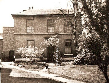
Mr. Taylor's cottage, date unknown

The caption just says, “old cottage near the meadows, Chorlton-cum-Hardy”, and to add to the lack of detail the image is undated.  

I might be able to track down when the image was first used by the Reaud picture postcard company, because we do have a catalogue number.

Trying to locate exactly where it was continues to be a challenge, but I think we are on what is now Brookburn Road, with the Bowling Green Hotel roughly behind us on what is now a new build, but was once the United Servicemen’s Club.*

The footprint of the cottage conforms to a property shown on the OS map for 1894, and is similar to ones which show up on earlier maps from 1854, back to 1818.

The cottage opposite the Bowling Green Inn

During the 1840s, it was home to a John Taylor who had been born in Chorlton in 1784, and gave his occupation as an agricultural labourer.  

The cottage was owned by the executors of John Renshaw who had an extensive property portfolio across the township, including Renshaw’s Buildings which were on the site now occupied by the Royal Oak Hotel.

By 1851 Mr. Taylor was still in a Renshaw property but had moved to a house in Martledge.

Judging by the census return from that year he was still working, although does appear to being sharing the home with a Mary Taylor who was six years younger and described herself as a “laundress”.

In time it will be possible to track some of the other residents, and determine when the house was demolished which I think may be the mid 1920s.

I have always been fascinated by this picture, particularly because it offers up an image of cottages which had once been typical of the properties in the township and may date back to the late 18th century.**

It looks to be larger than some labourer’s homes, which were one up one down, and it has space for a cottage garden.

Location; Chorlton

Picture; “old cottage near the meadows, Chorlton-cum-Hardy”, undated, from the Lloyd Collection, and its location from the Tithe map of Chorlton-cum-Hardy, 1845

* That club on Brookburn Road in Chorlton ....... and a fascinating find  https://chorltonhistory.blogspot.com/2020/08/that-club-on-brookburn-road-in-chorlton.html

**A property roughly in the right place shows up on Yate’s map of 1786.


Tuesday, 27 January 2026

Hampton House ......... and a mystery down on Edge Lane

This is about as close as we are going to get to Hampton House.

The garden wall of Hampton House, 1959
It stood just a little back from Edge Lane and gave its name to the road that now runs past its northern side.

Time has not been kind to the house or its memory and even the caption has helped wipe it off the map because there is no reference to Hampton House in what is otherwise a very detailed description.
“Chorlton-cum-Hardy, Edge Lane, Victorian Post Box, North east side: 10, Corner of Hampton Road, showing Victorian Post Box built into wall of semi-detached houses built in what was garden of Barway House”.

Now Barway House still stands, and is nu 28 Edge Lane, but the plot now inhabited by those semi-detached houses, behind the stone wall with its Victorian Post Box was home to Hampton House.

Like it's neighbour Hampton House was built around 1866 and was situated in its own grounds with a long straight drive which ran off from Edge Lane, past the house to what may have been a large stables.

Hampton House, 1894
I can track its residents through from the 1860s into the 20th century, and then the trail goes cold.  It is not listed on the street directories for 1903 or 1911 and is absent from the census records.

But there is perhaps a clue in the listing for 1909 which records that a Mr George Meredith was living there and described him as “caretaker”.

And that suggests that the owners were not there and that no one was renting the property which was also the fate of Barway House at about the same time.

But unlike Barway House which was reunited with residents later in the century Hampton House may not have been so lucky, because by 1921 it had been demolished and maps show the site remained empty until sometime in the mid 1950s when our semi-detached houses were built.

All of which begs the question of what might have been wrong with property.

It may have been poorly built or it might just have been too large.  By 1939 Barway House had been divided into flats and the adverts in Manchester Guardian show that the same fate had befallen some of other big houses in Chorlton.

In the end the answer will in part lie in a careful trawl of the street directories for the early part of the 20th century which if we are lucky will reveal the names of residents up to 1921.

Well we shall see.

Location; Chorlton

Pictures; Chorlton-cum-Hardy, Edge Lane, Victorian Post Box, North east side: 10, Corner of Hampton Road, showing Victorian Post Box built into wall of semi-detached houses built in what was garden of Barway House, A E Landers, m17775, courtesy of Manchester Libraries, Information and Archives, Manchester City Council, http://images.manchester.gov.uk/index.php?session=pass extract from the OS map of 1894 courtesy of Digital Archives Association, http://www.digitalarchives.co.uk/

Thursday, 22 January 2026

That mystery house on Beech Road ........

Now number 121 Beech Road vanished a long time ago.

Hunts Croft, circa, 1960s
It was one of our more elegant early 19th century properties which was set back from Beech Road, and went sometime in the 1970s.

For a long time after its demolition the land was left an open space, with the occasional suggestion that it could be a car park, a project which came to nought when the Corporation and the local traders couldn’t agree on a funding package.

There will be a few people who remember it, but sadly I am not one of them, which means it had gone before I arrived in 1976 or like so many things I was just not that observant back then.

Either way, there is little to mark its presence, save an entry in the tithe schedule for 1845, the Rate books and official maps.

If I have this right, it was Hunt Croft House and in 1845 was the residence of Thomas White who rented it from the Lloyd Estate.

With a lot of digging it will be possible to track its history through the 19th century till its demolition. I know that in 1969 it was occupied by a Frances. J Casse, and in 1911 by Mr and Mrs Chester, their five children, and a boarder.

Looking into the garden, circa 1970s
The house had nine rooms with a biggish garden at the front, ending in a tallish stone wall which ran along Beech Road.

Back in the mid 19th century it looked at on fields.  From the rear Mr White could look out on a field and orchard, while from his front windows he could gaze across to Row Acre, which stretched up to High Lane.

But by the 20th century the fields had all gone, and on either side of this fine old house were shops.

Beech Road, circa 1970s
And here I must admit my mistake, because for years I had mistaken Croft House for Joel View which stood a little further down the road and had been built in 1859.

Many will remember Joel View as the property owned by J Johnny, which I assumed had been built much later.

I even compounded the mistake by arguing that the stone tablet which carried the  name of Joel View had been salvaged from Mr White’s former home and been added to J. Johnny’s.

Dating the picture
Now, even then I knew that this was pushing it, because our own historian Thomas Ellwood had written that Joel View was one of the new developments in the township at the end of the 1850s.

All of which goes to show that sometimes when it is easy to ignore the obvious and create an elaborate theory which is built on sand and that is really just a lead in to two pictures of Hunt’s Croft sent to me by Roger Shelley who took them sometime in the 1970s and which had lain in his negative box until yesterday.

The two images compliment an earlier one taken by N. Fife for which I don’t have a date for, but maybe from the 1960s.

That said it might be possible to date Roger’s pictures, from the shop which is up for sale.  This had been Mr Westwell’s fruit and greengrocer shop in 1969, but sometime in the next decade became The Village Wholefood Shop.

Hunt's Croft demolished, circa 1979-early 1980s
It was still trading when I took a picture around 1979, showing the shop and the site which had once been Hunts Croft.

So that is it for now, although I am hoping Roger has more pictures.

Location; Chorlton


Pictures; Hunts Croft circa 1960s, courtesy of N Fife, the Lloyd Collection and again circa 1970s from the collection of Roger Shelley, and after it had been demolished circa 1979, from the collection of Andrew Simpson

Monday, 12 May 2025

That unusual picture of the old parish church ….. with a heap more

 This is one of my favourite pictures.


It has appeared countless times before on the blog, and I never tire of writing about it.

This is the old St Clement’s church which stood in in the parish graveyard on the edge of the village green.

I can’t be sure when the photograph was taken, but it was a Reaud picture postcard and was sent to a Miss Clay of Brooks Bar in the September of 1904.

By then the parish church which had served the township since 1800 had just another 37 years, before it was closed because of frost damage, and its congregation joined those of the new church on Edge Lane.


This tall brick church had replaced an earlier timber building which dated back to the early 16th century, and had originally been the Chapel of Rest for the Barlow family.

It is an unusual image and despite its “colorization” has a lot to offer.  Even after a good ten years of researching its history I have to say it is an ugly building, made more so by the two extensions added in the 1830s.

To our left is an old cottage which dates from the early 19th century and may already have been there when King George lost the American colonies.

In 1841 it was home to John and Mary Taylor. 

In the June of that year he had described himself as an agricultural labourer and a decade later aged 72 he was still working on the land while his wife took in laundry.


Now it is impossible to say which farm he worked for or whether he was part of the casual workforce which found work where they could, but there were three farms around the green and another along what is now Brookburn Road

They rented the house from John Renshaw who had owned properties around Chorlton and paid him 1/6d a week in rent. Now this was about the going rate for such a cottage although rents began at just over a shilling [5p].

The cottage stood on open land with fine views back across the green and out toward the Mersey. Like most homes of the day there was a small cottage garden.

Now using the tithe map it is possible to locate the spot the picture was taken and this was Lough Orchard Meadow which in 1845 was one of the fields James Higginbotham rented from the Egerton estate.


Like the surrounding fields it was meadowland which was set aside for growing early grass.  

Mr. Higginbotham rented land across the township, and lived in the farmhouse facing the church school across the village green.  His house is still there, although the barn beside it has been converted in to residential use.

I will leave it up to you to suggest exactly where that field is today.

Leaving me just to comment on the buildings to the east of the church which included another barn, while  lost behind the trees is the Old Bowling Green Inn, which dated back to the late 17th century and was torn down in 1908 to build the present pub.

And for those who like detail there are the arms of what will be a cart, sticking up into the air.

Pictures; St Clement’s Church, circa 1900, and Mr. Taylor's cottage, circa 1900, from the Lloyd collection 


Sunday, 20 April 2025

Who stole Alton Towers?

Today I was reminded by my old Facebook chum Bill Summers of that house on Edge Lane called Alton Towers.

Alton Towers, 1907
Like him I have often come across it on maps and set to the challenge he laid down today, when he posted the 1911 OS map showing the property adding, “We all know roughly where Alton Towers is or have heard of its pleasure grounds but might be surprised to discover there was another- in Chorlton cum Hardy back in the day. 

Just wondering if Andrew Simpson can tell us anything of it. 

It stood for a while at the side of St Clements Church on High Lane, so maybe there is a photo out there somewhere". 

It was a challenge I couldn’t turn down.

Today the site is open land and was gifted to St Clement's for the use of young people and is now part of the school, and that is pretty much how I remember it from when I washed up in Chorlton in 1976.

The site of Alton Towers, 1933
The last recorded reference to the house is on the 1911 census  but interestingly it is not listed in the street directory for that year and the OS map for 1933 shows it as open land with a tennis court in one corner.

So sometime between 1911 and 1933 it disappears.

I can track it back from 1911 to 1879, and I am fairly sure that 1879 marks the date when it was built.  

It was owned throughout by John Richardson who rented it out to just five tenants over those thirty years.

It had been a grand house with ten rooms, set back from the main road in a large garden and commanded an annual rent of £100 and a rateable value of £68.

And not to be short changed had a series of green houses arranged amongst the trees in the garden.

In 1911 it was occupied by an Edward and Christina Wright, their four children and two servants.  Mr. Wright described himself as a “Paper merchant" with his offices at 62A Fountain Street. 

The site in 2023
What happened after 1911 is yet to be discovered but I do know that one of his son’s was living at 22 Whitelow Road in 1917, because his Attestation papers say so.

It may be that the family moved from Edge Lane to Whitelow Road.

There is no reference to Alton Towers in the 1921 census, and sadly so far the only images we have are of a gate post on pictures dated in 1930 and 1959.

Sad looking gate post, Alton Towers, Edge Lane, 1930
Not that I am finished.

I shall explore the life of John Richardson, and talk to St Clement's Church about their acquisition of the land and follow up the story of a fire.

so heaps to find out.

We shall see.

Location; Edge Lane

Picture, Alton Towers, 1909, OS map for Manchester and Salford, 1909, site of Alton Towers, 2023, courtesy of Google Maps and Only a sad looking gate post, Alton Towers, Edge Lane, 1930, m17809, courtesy of Manchester Libraries, Information and Archives, Manchester City Council, http://images.manchester.gov.uk/index.php?session=pass


Saturday, 8 June 2024

Breaking News …… more on the mystery of the lost Chorlton Alton Towers

Yesterday I was exploring the strange story of Alton Towers which stood on a large plot of land beside St Clements Church.*

The site of Alton Towers, Edge Lane, 2022
I can date it to 1879 and track the owner and the tenants over the next 40 years 

It was a grand ten roomed house with greenhouses set in a large garden with an accompanying parcel of land with trees and pathways.

But sometime after 1915 it disappears from the historical record and by 1933 the house is gone and a tennis court occupied one corner of the land. 

Alton Towers, 1907
Dave King remembers being a member of the club and playing in the courts in the 1970s.

The house has rather entered Chorlton mythology with a vague assertion that there was a fire and that the Council appropriated the land.

And today thanks to Tony Goulding who writes for the blog and who digs deep into the Township’s past l can add more.

Having become interested in the story Tony found two newspaper accounts. 

One refers to a tragedy in the grounds of the house in 1915 when a young boy playing in the grounds of Alton Towers fell from a tree in a “private garden”, and “Lockjaw supervened on the injuries and he died from that cause”.**

Fatal Trespass, 1915
My NHS site tells me that lockjaw is now referred to as “Tetanus [which]  is a serious, life-threatening condition caused by bacteria getting into a wound. It's rare in the UK because the tetanus vaccine has been part of the routine vaccination schedule for many years”.***

Not so of course a century.

It is a sad story but does help with the mystery of the house which might still have been there.

We know according to another newspaper account found by Tony that it had been put up for auction two years earlier on October 23rd, 1913.

Up for auction, 1913
The sale notice refers to “The Excellent Freehold Detached Residence known as ‘Alton Towers’ Edge Lane, Chorlton.”

And goes on “The site contains 3,230 square yards or thereabouts, and is subject along with an adjoining plot of land containing 4, 370 square yards or thereabouts to a perpetual yearly rent charge of £63”.***

So, we now know a tad more about that mystery house, and no doubt more will emerge.

And it did because, just a few hours after the story went live, Tony Goulding added the comment, "There is also an advertisement in the Manchester Evening News of 27th February 1914 for the sale by private contract of bricks, slates, and other assorted building materials for a number of addresses including Alton Towers, Edge Lane. 

Sad end ..... that house reduced to builder's items, 1914

It is likely that these items were the product of the demolition (actual or proposed) by the seller, G.H. Jones, Blackfriars Road, Salford".

And not to be out classed I went looking for the advert and Found it umpteen times from mid February through to the end of March 1914.

Location; Edge Lane

Picture; the site of Alton Towers, 2022, courtesy of Google maps, in 1907 from the OS map of Manchester & Salford, 1907, two newspaper accounts, 1913 & 1915,  courtesy of Tony Goulding, and Bricks etc, Manchester Guardian, February 17th, 1914

*Who Stole Alton Towers? https://chorltonhistory.blogspot.com/2024/02/who-stole-alton-towers.html

***Tetanus, NHS, https://www.nhs.uk/conditions/tetanus/

****To be sold by Auction, Manchester Evening News October 18th, 1913

Friday, 5 April 2024

After the children have gone ….. Gable Nook … some doctors ..... and a story

Gable Nook is that slightly sad looking house on the corner of Wilbraham and Corkland Road, and it is clearly waiting for something to happen.

Gable Nook ... waiting for something to happen, 2024
Once on any weekday it would be full of nursery children doing what nursery children do.

But now the playground is covered in moss, the happy busy kid’s posters in the windows are fading and in one upstairs room hangs a flag making a statement on a war.

It’s last Ofsted report in 2018 judged it “Good” and had plenty of positive things to say.*

But sometime after that it closed, and it is beginning to look a bit ghostly.

Overgrown, 2024

All of which is a shame for a building which dates from 1890, had eleven rooms and commanded fine views of the new railway station.

It’s first occupant was an Alfred Alexander Mumford who was a surgeon and continued to live and practice there until around 1909.

In happier times, 2013
Thereafter it came the surgery of Helm and Steele-Smith and was still doing the business in 1939.

I last wrote about it in 2013 when it was still looking after children. **

After that at present I have yet to find out what happened to the building, but I know that the Gable Nook Nursery opened in 1992, which offers up just a short window of 53 years to research, but then someone might know.

We shall see.

And within a day I have been told that it was a nursery going back through the 1980s back into the 70s and onto the 1960s.

Location; Chorlton

Pictures; Gable Nook, 2013 and 2024, from the collection of Andrew Simpson

*Gable Nook Day Nursery, Ofsted, https://reports.ofsted.gov.uk/provider/16/500085  

**Old houses and forgotten stories, four houses on Wilbraham Road in 1911, https://chorltonhistory.blogspot.com/2013/07/old-houses-and-forgotten-stories-four.html

Wednesday, 19 July 2023

So goodbye to Carlton House on High Lane ……… well almost

Carlton House is that building on High Lane and Acres Road.

Carlton House, 2022
For well over a century, it has been in the business of education, starting out as a convent school and then becoming the Islamic High School for Girls.

But all that is about to change as the Islamic High School is relocating to West Didsbury and the site is about to be redeveloped.

Cube Homes propose to build “22 high quality, energy efficient and sustainable new homes comprising 14 four bedroom townhouses, 6 two-bedroom apartments, and the retention and refurbishment of Carlton House, which will be converted into 2 homes”.*

We are at the early stage where Cube Homes have bought the land, had preliminary discussions with the Planners at the City Council and have floated a “Preapplication” statement and consultation.

The Convent, 1959
All of the details are available online and make for an interesting read, particularly because the developer amended the plans in the light of conversations with the City Planning Department.

One of which was the retention of Carlton House.

It is a building I have passed countless times but never once gave it much thought.

For most of the time I have lived in Chorlton it was the Convent School before becoming the Manchester Islamic Grammar School For Girls.

But it started as the home of Thomas and Catherine Harrison who I suspect were pleased with their impressive property which consisted of 10 rooms with a garden which stretched down towards Beech Road and included stables, a greenhouse and heaps of ancient fruit trees.

I have written its story and always intended to go back.  That first story set off a heap of memories from those who attended the convent school and no doubt the second will bring forth more from its time as the Islamic High School.**

Carlton House and garden, 1894

Now the historic records offer up heaps of possible avenues of research including the cottage which  stood on the site in the 1840s and 50s, when this strip of land was owned by William Brundrett.

But also highlight just how twisty turny historical research can be, because I came across Carlton House almost by accident as I was looking for the story behind 97 Beech Road which if I have got it right dates back to 1886, and has in its time sold many different things

Carlton House dates from 1866 and may have been sold in 1898 when Mrs Harrison died.  Either way sometime between 1903 and 1909 her grand house became the Convent. The 1911  census records it was home to the Principal, six teachers, one pupil teacher and the house keeper.  

Walking the garden wall, 2020
They ranged in age from 49 down to 18 years old, all were single, and were drawn from across the country and beyond.  So, while four were from Ireland, one was from Dorset and the remaining three had been born in Woolwich, Hackney and London.

And now that link with education has come to an end.

I could at this point reflect on the proposed plans, or the bigger issue of new homes in Chorlton but I won’t, suffice to say the proposals recognises that despite real  environmental concerns provision has been made for more than one car per house hold, which in turn may prevent the squeeze on on road parking.

Added to which Acres Road is to be widened, which clearly makes sense.  The historian in me acknowledges that this will alter the historic character of what was popularly known as “Acres Crack” and originated as a small watercourse covered over sometime before the 1880s, but the trade off is the retention of Carlton House.

That said the scale of the development does seem over large for that corner of Acres Road.

So, the rest are stories yet to come.

Location; High Lane

Pictures; Carlton House, and the line of what was once the garden, 2022,  from the collection of Andrew Simpson, Carlton and house and grounds 1894, from the OS map of South Lancashire, 1894, courtesy of Digital Archives, https://digitalarchives.co.uk/  and Convent of the Sisters of the Christian Retreat, 1959, A.E. Landers, m17917, courtesy of Manchester Libraries, Information and Archives, Manchester City Council, http://images.manchester.gov.uk/index.php?session=pass

*Cube Homes High Lane Consultation, https://www.cubehomeshighlaneconsultation.co.uk/?fbclid=IwAR0RpY4WJSNMpEm-cSD6fIFNrQfHjnh9M1Dhccez1k9WCISxdPBYZTNpfyA

**Carlton House …… the convent on High Lane and …….. the trail that led back to a Beech Road bar

https://chorltonhistory.blogspot.com/2022/10/carlton-house-convent-on-high-lane-and.html


Wednesday, 5 April 2023

Carlton House …… the convent on High Lane and …….. the trail that led back to a Beech Road bar

This was Carlton House on High Lane which was the home of one family from 1866 to the early years of the 20th century.

Carlton House, 2022
And it is a building I have passed countless times but never once gave it much thought.

For most of the time I have lived in Chorlton it was the Convent School before becoming the Manchester Islamic Grammar School For Girls.

But it started as the home of Thomas and Catherine Harrison who I suspect were pleased with their impressive property which consisted of 10 rooms with a garden which stretched down towards Beech Road and included stables, a greenhouse and heaps of ancient fruit trees.

Just how long that garden was can be gauged by walking down Acres Road from High Lane and following the brick wall of the present school.

Carlton House, 1894

I have yet to find out when Thomas died but I know it will have been before 1871 when Catherine was recorded as a “Widow” at the age of 44.  

She died in 1898 leaving £29,511, and sometime between 1903 and 1909 Carlton House  became the Convent.

Walking the garden, Acres Road, 2022
Two years later the census records it was home to the Principal, six teachers, one pupil teacher and the house keeper.  

They ranged in age from 49 down to 18 years old, all were single, and were drawn from across the country and beyond.  So, while four were from Ireland, one was from Dorset and the remaining three had been born in Woolwich, Hackney and London.

Now the historic records offer up heaps of possible avenues of research including the cottage which  stood on the site in the 1840s and 50s, when this strip of land was owned by William Brundrett.

But also highlight just how twisty turny historical research can be, because I came across Carlton House almost by accident as I was looking for the story behind 97 Beech Road which if I have got it right dates back to 1886, and has in its time sold many different things

Some will remember it as Marcelle’s Fabric shop, and later briefly when it sold “interesting things” before settling on a succession of bars and cafes.

 Convent of the Sisters of the Christian Retreat, 1959
And here is the connection with Carlton House, because 97 Beech Road had been built and owned by William Henry Acton who was the son in law of Thomas and Catherine Harrison. 

In 1871 he was living at Carlton House along with his granddaughter and at 28 was already a widower. 

So, the project turns on where next?  

I know that Mr. Acton was still on High Lane in 1901 but along with other members of the family had retreated to the delights of a large hotel or guesthouse in Bournemouth, having described himself as a “Wood carver” in 1871, forty years later was styling himself “retired builder”.

Or equally fascinating might be a study of the Convent which I am sure will elicit plenty of memories, or the cottage on High Lane before Carlton House.

Beech Road Tap House, 97 Beech Road, 2020

We shall see.

97 Beech Road, 2023

And an anonymous contributor reminded me that "No 97, I remember after Marcelle's was 'Jean Genie', a card / gift shop, and also that 'interesting things' shop you mention, before becoming 'the Library', the 'Tap House' and latterly the short-lived 'Seb's Bar'".

Which reminded me that I had passed the latest "happy" venue to occupy 97 Beech Road, which is appropriately named 97.

Location; Chorlton


Pictures; Carlton House, and the line of what was once the garden, 2022, Beech Road Tap House, 2020,and (7 Beech Road, 2023,  from the collection of Andrew Simpson, Carlton and house and grounds 1894, from the OS map of South Lancashire, 1894, courtesy of Digital Archives, https://digitalarchives.co.uk/  and Convent of the Sisters of the Christian Retreat, 1959, A.E. Landers, m17917, courtesy of Manchester Libraries, Information and Archives, Manchester City Council, http://images.manchester.gov.uk/index.php?session=pass