Showing posts with label My Manchester. Show all posts

Wednesday, 29 July 2026

In Albert Square with the unusual ..........

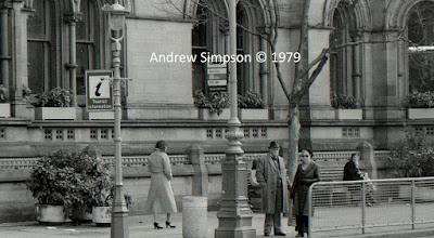
Now for anyone born before 1970 there will be nothing odd about a bus stop in Albert Square, or the parked up black cabs.

Equally the presence of two underground public lavatories either side of Albert will be no surprise.

That was just what the square was like, pretty much from its construction to sometime in the 1980s or '90s, when the public lavatories, the taxi rank and the bus stops disappeared.

And like so much modern history I can’t remember exactly when it all happened.

Of course the serious side of me knows that I should go off and find out but I bet someone will know and come back with chapter and verse which is always more fun.

Added to which they, or some else, will also be able to explain what happened to the two public lavatories.

Were the fittings carefully and lovingly taken out, and perhaps placed elsewhere or was the void just back filled?

And if it is the latter that raises fascinating thoughts about the discoveries and theories put forward in future archaeological papers on the “Role and significance of underground public services”.

Still for now, I can’t say I miss the bus stops and take pleasure in just sitting in the square, admiring the Town Hall, and pondering on the plight of those underground public lavatories.

Leaving me only to admit that there is still a taxi rank in the Square and the buses still stop but not not directly outside the Town Hall.

Location; Manchester

Pictures; Albert Square, 1978, from the collection of Andrew Simpson

Thursday, 23 July 2026

What we have lost ....... inside the Corn Exchange

I really liked this metal and glass structure.

It was in the Corn Exchange beside Exchange Square, and I always thought it was an innovative way to fill a space.

Added to that I rather enjoyed sitting in there sipping an espresso and waiting for the shopping expedition to finish.

But it has gone since then the space around it was transformed from a retail centre to a series of themed restaurants from Italian, to Thai, and many more.
The Corn Exchange is a listed grade II building and was originally the Corn and Produce Exchange built in 1897 and opened in 1903.

Its role as an important centre for business suffered during the 1920 and 30s and and by the time I arrived in Manchester in 1969 its role as a trading floor were over.

But I remember it as a place full of independent traders ranging from second records and comics to clothes and jewellery.

You could spend hours wandering the stalls on the trading floor and in the surrounding rooms, but that IRA bomb did for all this.

The building was severely damaged and many of the traders relocated to what has become the Northern Quarter, and the building was redeveloped as the Triangle specialising in swish retailing, but it never seemed as busy in later years, and despite a re branding in 2012 seemed to miss a trick.

And then it closed reopening as an interesting place to eat.


Location; Manchester


Pictures; interior of the Triangle, July 2013

*Corn Exchange, Manchester, http://en.wikipedia.org/wiki/Corn_Exchange,_Manchester


Monday, 20 July 2026

Lost and forgotten streets of Manchester .......... nu 3 Tasle Alley

Now Tasle Alley is one of those places most people will pass without a second glance.

It is the gap almost on the corner of John Dalton Street and Albert Square which with its double yellow lines which often looks dark and gloomy can’t be much of an attraction.

On the other hand for the curious that little ginnel beside New Church House on John Dalton Street suggests an adventure and if you plunge in the tunnel leads on to Tasle Alley and through a second tunnel to Mulberry Street and St Mary’s Chapel which is more popularly known as the Hidden Gem.

As late as 1849 Tasle Alley lay open on its northern side but within two years that open land had been built on and it became the narrow alley we know today and as these things go it didn’t even warrant a listing in the street directory.

I had thought that just perhaps because the buildings seem to date from 1851 they had missed being incorporated in the street directory for 1850, but no, Mr Slater's fine Directory for 1863 stubbornly refused to list  anything for the alley.

Tasel Alley, 1849
By 1900 the alley had a set of warehouses which were mainly furniture and printing with a wine merchants and a set of offices.

So that is about it.


Location; Manchester


Picture; Tasle Alley, 2016, from the collection of Andrew Simpson, and in 1849 from the OS of Manchester & Salford, 1842-49, courtesy of Digital Archives, http://digitalarchives.co.uk/ 

Saturday, 18 July 2026

Walking the city of Manchester in 1841 .......... courtesy of Mr B Love

Now I bet the Handbook of Manchester would have caused a stir amongst the elegant tea rooms and learned libraries of London back in 1842 when it was published.* 

After all our city was as Asa Briggs said “the shock city of the Industrial Revolution" and as such was on the itinerary of both British and foreign commentators keen to know what was going in the North.

And it is worth giving the full title of the book because it lays out just what it is about  The Handbook of Manchester, containing statistical general information on the trade, social condition, and institutions of the Metropolis of Manufactures: was published in 1842.

It was according the Preface a “new and it is presumed, a greatly improved edition of ‘Manchester As It Is,’ – published in 1839.  

Considerable pains have been taken to render this volume one of the most complete of its kind.”

And here are chapters on all the major manufacturing industries, descriptions of the population of the city and surrounding towns and townships and much on the conditions of those who lived here.

It is in short a wonderful bit of history and sits alongside those others by Dr Kay, Mr Engels and many more.

It praises the beauty of many of the new buildings and the industrious nature of its residents but has a keen social eye, commenting that the river Medlock and the river Irk “are made extensively available for manufacturing purposes; hence their waters are thick, black and filthy.”

And for me it will be when Mr Love explores the lives of the cotton workers, along with chapters on the charities, the social scene and crime when the book becomes fascinating.

So there you have it and I am thinking there will be plenty more to come.  The Female Penitentiary and the information on aspects of the city's population were drawn from random and just caught my eye.

Location; Manchester 1841

Picture; Female Penitentiary Emdben–place, Greenheys, 1841, and data from the 1841 Census represented in The Manchester, Handbook, 1842 

*The Handbook of Manchester containing statistical general information on the trade, social condition, and institutions of the Metropolis of Manufactures: being a second edition of Manchester as it is, by B. Love, member of the Literary and Philosophical Society of Manchester, 1842   And is available as a download from Goggle Books

*Victorian Cities, Asa Briggs, 1963

Wednesday, 17 June 2026

Lost and forgotten streets of Manchester nu 22 .............. Milk Street

Milk Street is one of those streets I never really noticed.  


Milk Street, 2016
It runs from Marble Street to York Street but once started at Phoenix Street.

Today there is little you can say about it.  Its only notable feature is that concrete lattice wall which hides the entrance to an underground car park, otherwise you are faced with the backs of several buildings.

Now if I dig deep enough I might be able to discover the origins of its name which might have something to do with dairies and the practice of keeping cattle in the city centre.

But if so It will predate 1793 when Milk Street was already there.

By 1850 its residents consisted of six businesses ranging from manufacturers, to a paper.

Milk Street, 1849
There were plenty of other properties including two closed courts and at the junction with York Street the Concert Tavern and the Queen’s Theatre.  The latter was swept away in 1901 for the Parr’s Bank.

And that is it.

Location; Manchester


Picture; Milk Street, 2016 from the collection of Andrew Simpson
and in 1849 from the OS for Manchester & Salford, 1842-49 courtesy of Digital Archives Association,  http://digitalarchives.co.uk/

Monday, 8 June 2026

Lost and forgotten streets of Manchester nu 24 Barton Square .......... all in a name change or two

Barton Square, 2016
Barton Square is that narrow little street that runs from Exchange Street round to St Ann Street and is dominated by Barton Arcade that 19th century shopping mall more glass than wall.

I use it quite a lot and I always let my imagination wander as I follow its twisty route but until recently I had never given much thought to its name.

Barton is obvious given the arcade, but square seemed a little odd, after all this is a street. 

I supposed there might be a connection with St Ann's Square but that seemed remote and the more I thought about it even Barton threw up a puzzle given that the arcade was built in 1870 and the street is there a century before.

So as you do I went looking at the old maps of the area and the story is as complicated as you could expect.

In the 1840s and 50s that first stretch leading to the arcade was Red Lion Street which extended  under what is now the arcade just stopping short of Deansgate with four little side streets around a small square called Barton’s Buildings.  These were accessed via an entry.

Red Lion Street & Back Square, 1851
And that almost offered up the answer, but not quite, because the rest of what we now know as Barton Square had undergone a number of name changes, from Back Square in the first half of the 19th century to Back St Ann’s Square in 1793.

So mystery solved, and with a bit more digging it should be possible using the directories to pinpoint the date it all became Barton Square which it was by 1900.

Leaving me only to record that in 1851 Red Lion was occupied by mix of professional occupation including an accountant, commission agent, stockbroker and consulting engineer while Back Square was full of small manufacturing businesses.


As for Barton's buildings these belonged to a Mr Barton and consisted of four warehouses and an office with a joint annual rental income of £305 which were occupied by George and Edward Wood who dealt in cotton and cotton waste and and Tobler Anschelf & Co listed as merchants.

Location; Manchester

Pictures; Barton Square, 2016, from the collection of Andrew Simpson, and in 1851, from Adshead’s map of Manchester, and in 1900 from Goad's Fire Insurance maps, courtesy of Digital Archives Association, http://digitalarchives.co.uk/

Saturday, 6 June 2026

Lost and forgotten streets of Manchester nu 21 .......... Parsonage Lane

Now Parsonage Lane really is one of those little side streets which grows wider as you follow it down from Deansgate to Parsonasge.


It was there by 1793 and was already fronted by a selection of properties.

Fast forward half a century and these included a textile factory, the Admiral Hatchlock which also went under the name of Parsonage House, five other properties and the entrance to a closed court.

A search for Admiral Hatchlock drew a blank although I do know that our textile factory had by 1851 become Charlton & Sons Calendar Works which by 1900 had expanded across the road.

Today the original site of the textile factory is a big red office and retail block which is home to the Liquor Store.

And that is the close you will get a to buying a drink on Parsonage Lane because our pub which was still there in 1900 has long gone.

Location; Manchester

Picture; Parsonage Lane, 2016 from Deansgate from the collection of Andrew Simpson

Monday, 1 June 2026

Lost and forgotten streets of Manchester .......... nu 12 Chancellery Lane

Now I had wandered over to Spring Gardens to find Concert Lane and instead rediscovered this last bit of Chancellery Place most of which is broad enough but then narrows as it does a slight twist and opens up on Pall Mall.


Both of them are streets I have known for forty years and just rather took them for granted, but now I am wandering them all over again

Location; Manchester


Picture; Chancellery Place, 2016, from the collection of Andrew Simpson

Sunday, 31 May 2026

Lost and forgotten streets of Manchester .......... nu 13 Old Bank Street

Now I know that Old Bank Street is not lost and has not been forgotten.


It is after all used by heaps of people every day taking the short cut from St Ann's Square up on to Cross Street.

But it's narrow, has been there a long time and so qualified.

Location; Manchester

Picture; Old Bank Street, 2016, from the collection of Andrew Simpson

Saturday, 25 April 2026

Lost and forgotten streets of Manchester .......... nu 6 Bootle Alley

Now you could be forgiven for missing Bootle Alley which was always a very poor second to Bootle Street which twists up from Deansgate to Mount Street directly opposite the back of Central Ref. 

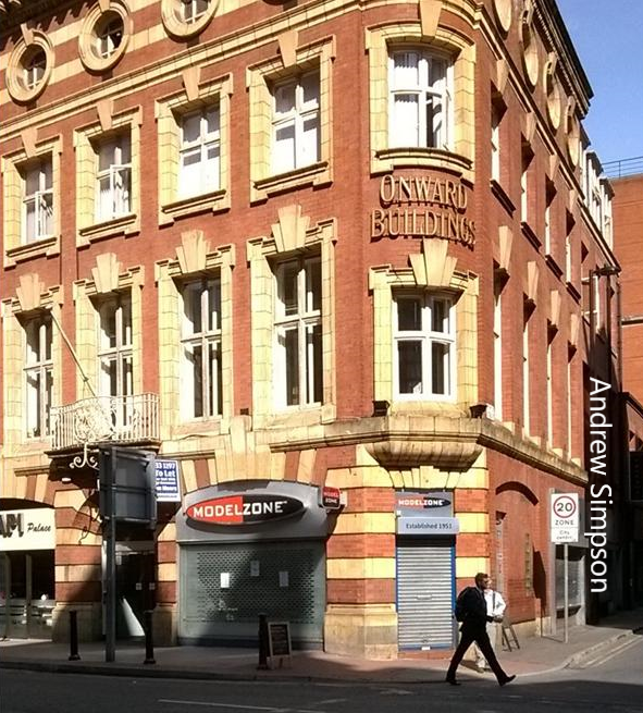
Onward Buildings,  with the alley just to the north, 2014
Its main claim to fame is that it is home to the pub, Sir Ralph Abercromby and of course a police station.

Walk along it today and you will be plunged into one of those narrow thoroughfares which with just a little bit of imagination takes you back to the early 19th century.

And once running parallel was Bottle Alley which gave access to the dark and dismal courts of Munday Square and Royle’s Court which between the two accounted for nineteen back to back cottages.

Its northern side faced onto the old Quaker Burial ground and its southern side was occupied by nine properties one of which gave access to a closed court which didn’t even merit a name.

And for those emboldened by an evening in the Sir Ralp Abercromby there is just a hint of that long vanished alley in the space between 201 Deansgate and the neighbouring restaurant.  It advances no more than a few paces before an iron gate bars the way.

Bootle Alley, 1849
So insignificant is the alley today that I have never got round to taking its picture.

Which means you will have to be content with a picture of the southern end of Onward Buildings which is the bit at the corner with Bootle Street.

Looking at the maps the lane still existed in 1900, although by then the courts had vanished.

On the burial plot stood the warehouse and offices of Leech Brothers and Manchester Corporation’s Joiner’s Shops, while directly opposite all those buildings running from the alley to Bootle Street had been cleared in preparation for Onward Buildings.

And now it is being transformed again with those huge developments.

Location; Manchester

Picture; Onward Buildings 2014, from the collection of Andrew Simpson, and detail of Bootle Alley, 1849 from the OS of Manchester & Salford, 1849, courtesy of Digital Archives Associationhttp://digitalarchives.co.uk

Saturday, 11 April 2026

When the media rediscovers the North

Now every so often the media discovers a place called the North.

The Dinner Hour Wigan,  Eyre Crow, 1874
In the 19th century observers from the south and indeed as far away as France and Germany made the journey north to our great industrial cities to report on how steam, machinery and textiles were transforming what had been small Georgian towns into densely populated places of enterprise and industry.

Along with creating new concentrations of people in remote valleys where a single textile mill or coal mine took advantage of fast flowing water courses and rich veins of the dark stuff.

The visitors marvelled at the new ways of production, were repelled by the awful housing conditions and shuddered at the life expectancy of many who worked in the factories, foundries, and dyeworks. 

As early as 1776 Matthew Boulton, who had teamed up with James Watt to make and sell steam engines, proudly announced to James Boswell, “I sell here, Sir, what all the world desires to have – POWER”

And just under two centuries later, the historian Asa Briggs described Manchester as “the shock city of the Industrial Revolution”*.

The Forging of the North, Observer, 1965
In between, novelists, social observers and Government officials regularly reported on the energy, novelty and squalor they found in the North, while in the years after the Great War, writers like George Orwell wrote vividly of the decline in the heavy industries, and its impact on unemployment and life chances.

Not that this should surprise anyone who lives in the North or that it remains a topical subject for political pundits, news programmes and journalists, who picked over the bones of the Northern Power House between 2010 and 2016 and more recently all the promises of “Leveling Up”.

As ever the devil is in the detail as many who have made a train journey from Manchester to Leeds or Sheffield will testify.

All of which is an introduction into a collection of old colour supplements from the Sunday Times, and the Observer, that came north with me nearly four decades ago

In 1965 the Sunday Times looked at how traditional values had changed in the North, including an iconic picture of two women out in Elland in West Yorkshire with their hair in rollers half hidden under scarves.

A year later and the Observer weighed into the topic with three part look at the North.  The first focused on “The Forging of the North” which examined “the story of the national epic”, ranging over all the basic heavy industries, the great northern cities as well as the smaller towns and villages and a collection of “Victorian worthies” most of whom have faded into obscurity.**

Sadly, the second of the three has been lost but was on the decline of the basic industries, while the third looked at “New fortunes old Myths”.  

Manchester skyline, 1965, Observer Magazine, 1965

Reading through the six articles of number three 58 years on I am struck by the mix of factual and perceptive reporting which is peppered throughout with  more than a few stereotypical assumptions.  

So, one article pointed out the inadequacy of some civic planning departments reporting that “When John Millar, Manchester’s new chief planner arrived in 1961 charged with redeveloping the crumbling central area, he had a staff of one elderly man…..[which meant that] when the development boom reached the Northern cities in the early 1960s places like Manchester hadn’t even sufficient staff to insist on comprehensive redevelopment orders.  Reluctantly they were bulldozed into accepting piecemeal schemes”.

I don’t doubt the accuracy of the statement but can’t square it with the sweeping and exciting plans of post war Manchester laid out in the City’s 1945 Plan.  But then it might be the difference between the plan and its execution.

Manchester 2021
Away from the factual reporting there was a slightly “southern prejudice” reflected in the surprise that northern working class women had discovered fashion.

And so half way through a piece on “The New North” was a caption under a photograph of some mill girls which ran “Young people in the North today follow and make fashion.  Above stylishly dressed and coiffed girls in a mill in New Mills”, as if factory girls had not always been keen on fashion and looking good.   

A cursory glance at the idealized painting the Dinner Hour, Wigan, by Eyre Crow from 1874 shows a group of young women with colourful scarves, shawls and hairdos which are carefully protected by hair nets.***

And it turns up again on a photograph of the new town of Peterlee in County Durham with its street of modern houses and piles of NCB coal which have been delivered to the curb side.  

Now having lived in the North East I know about the coal, but can’t quite escape that other historic southern notion that working class families kept their coal in the bath …… those of course of them who had a bath.

But the prize must go to the last article “Nothing Fancy in Coronation Street” where “Shirley Conran has a typical North Country meal with Violet Carson – television’s Ena Sharples”.  The dishes offered up were Bacon ribs on onion, Lancashire hotpot, Roast Beef, Yorkshire pudding and Bakewell Tart. 

The Avenue, Spinneyfields, 2021
All of which could be found anywhere in the country and certainly on the table in our house in south east London.  

Added to which was the final comment on wine in the North.

Both my parents who were from the North and the Midlands would have smiled at Cyril Ray who was then the wine columnist for the Observer who concluded the article with “Lancashire would rock with laughter if I recommended a wine to go with hot pot. Stout is the thing”.

I await stories of hair rollers, and a succession of examples where "northern life styles" are a part of essential life from Watford down to Bristol and across to Caney Island and Norfolk.

Leaving me to go off and pour over the accompanying commentaries on life in the North in the age of Levelling Up, and remember that it was Doctor Who who said, "Every planet has a North".

Location, that big place called the North

First posted 2022. 

Pictures; , The Dinner Hour, Wigan. The Forging of the North, Observer, January- February, 1966, Eyre Crowe, 1874, Manchester City Art Galleries, and Manchester in 2021 from the collection of Andrew Simpson

*Asa Briggs, Victorian Cities, 1963

**The Forging of the North, Observer Magazine, January-February, 1965

***The Dinner Hour, Wigan, Eyre Crowe, 1874, Manchester City Art Gallery, https://manchesterartgallery.org/collections/title/?mag-object-2265
Tuesday, 10 March 2026

The sandwich board ............ a century apart

Advertising the Palace Theatre, 1896
Once the man with a sandwich board was a common site on the streets of all our towns and cities.

And then sometime after the last world war they seemed to disappear.

I guess it was part of that more slick way of advertising which relied on TV to get the message over.

But they are back usually advertising fast food and can be seen following the main routes into the city or as in this case at St Mary’s Gate close to St Ann’s Square.

Some firms have gone that step forward and produced a sign which mimics the product.

And like their predecessors a century ago they walk the streets in all weathers, come rain, hail or sun.


Fast food, 2015

Back in 1896 Henry Tidmarsh recorded what he saw on the streets of Manchester.  In all he produced over 300 illustrations for the book Manchester Old and New.

It was published in 1894 by Cassell with a text by William Arthur Shaw and told the history of the city but the real value of the book was in Tidmarsh's vivid depictions of Manchester, with streets and buildings animated with people.

Location; Manchester


Pictures; At St Mary’s Gate, 2015, from the collection of Andrew Simpson, and by St Peter’s Church, 1896, Henry Tidmarsh, from Manchester Old and New, William Arthur Shaw, 1896

Tuesday, 17 February 2026

A scene now lost in time ............. looking out from the short lived cafe in Piccadilly Railway Station

Now that I grant you is not the most imaginative title but it does the business for this scene looking out across the city.


It was taken just after the railway station had its makeover.  Back then this space was a cafe and on a warm day I wandered in took a few pictures promised myself I would return only to discover it had become a supermarket.

Such are the ups and downs of the amateur photographer.
And I know I have featured it before and for those wanting to challenge the date I have to say I can’t remember.

Location; Piccadilly Railway Station

Picture; view from Piccadilly Railway Station, circa 2003, from the collection of Andrew Simpson

Thursday, 12 February 2026

Rediscovering Cheetham .............. nu 1 the Manchester Ice Palace

Now I will leave the story of Cheetham, Strangeways and Redbank to  those who are far more qualified to write about its history.*

Instead I shall feature some of Andy Robertson’s pictures from his collection taken of the area during August 2015.

It is thirty years since I was a regular visitor to the Strangeways area, and much has changed. 

In particular that area in the bend of the river which had once been a  notorious slum and which I knew as open ground has now been built on again.

But a few of the buildings which date to when the area was a thriving centre of Jewish life have survived.

And so here is the Ice Palace on Derby Street which Andy commented “was opened in 1910 and once reputed to be the finest ice skating rink in the world.”

Picture; The Manchester Ice Palace, 2015 from the collection of Andy Robertson

*The  Making of Manchester Jewry, 1740-1875, Bill Williams, 1976

Wednesday, 11 February 2026

Surprises ……. St Matthews Sunday School

I have always liked the former St Matthews Sunday School that stands on Liverpool Road.


It is a simple but pleasing building which I think was paid for out of a fund created by the Government to commemorate the victory at Waterloo.

My Pevsner’s just records, “St Matthew’s Sunday School, dated 1827, converted to offices in the 1980s. Brick, two storeys, with an apsidal s end and windows with pointed arches and simple Y-tracery”.*

Given the whole sale destruction of many of the buildings along the road, it is always a surprise that it survived.

But survive it did, and this is the rear, on Rice Street.

Location; Castlefield

Picture; St Matthews Sunday School, 2022, from the collection of Andrew Simpson

*Manchester, Clare Hartwell, Pevsner Architectural Guides, Penguin Books, 2001, p269


Tuesday, 10 February 2026

A little bit of retail history ………. in the Arndale

Now I have never lost my liking for this bit of early 21st century retail technology.


It is in part the quirky shape, and the bold colours which I know someone will point out was less silly and more the demands of  logical technical design.

But I liked it, and now its gone.

Location; the Arndale, Manchester

Picture; Retail furniture, Manchester, 2003, from the collection of Andrew Simpson


Friday, 16 January 2026

Lost and forgotten streets of Manchester nu 25 Ashley Lane ............. now even the name is lost

Now Richard’s picture of Aspin Lane as it runs under the railway viaduct is as atmospheric as you could get.

Aspin Lane, 2016
The wet stone setts, the lonely lane framed by that viaduct takes you back a century or more to another age when this bit of Angel Meadow was one of those places where “poverty busied itself.”

Like Richard I have spent many years wandering the streets around the old St Michael’s Rec and burial ground.  In my case it came after meeting the historian Jacqueline Roberts, reading her book on the area and using some of her material in classes I taught on working class housing in the 19th century.*

And it was she who first introduced me to the idea of using census material to engage students in exploring social history.  The unit focused on the streets around Irk Street, John Street and Back Ashley Lane in the 1851.

Ashley Lane, 1849
Here in just 16 houses lived 120 people, making their living from a variety of occupations from factory work, to cap makers, porters and that lowest of jobs, a brush maker.

Some like Mr and Mrs Shaw and their three children lived in the cellar of number 3 Back Irk Street, while round the corner at nu 3 John Street the eight members of the Riley family were squeezed into one of its two rooms.

So Richard’s photograph drew me in but as hard as I looked there was no Aspin Lane on the old maps, but that was simply because Aspin Lane was indeed Ashley Lane and an unknown photographer had got there before us and in 1910 took a picture from almost the same spot.

Ashley Lane, 1910
But all stories deserve a second look.

And after my old facebook friend Bill questioned me on my comment on the status of brushmakers I went looking for more on them. 

And the Working Class Movement Library offered some interesting detail, leading me to correct my assumption this was a precarious and low status occupation.**

Location; Angel Meadow

Pictures; Aspin Lane, 2016 from the collection of Richard Hector- Jones, and in 1910, m00218, courtesy of Manchester Libraries, Information and Archives, Manchester City Council, http://images.manchester.gov.uk/index.php?session=pass  and in 1849 from the OS for Manchester & Salford, 142-49, courtesy of Digital Archives Association, http://digitalarchives.co.uk/

*Roberts, Jacqueline, Working Class Housing in Nineteenth-century Manchester: The Example of John Street, Irk Town, 1826-1936 1983

***Brushmakers, Working Class Movement Library, https://www.wcml.org.uk/our-collections/working-lives/brushmakers/

Friday, 3 October 2025

If it wasn’t for the houses in between you could see all the way across the fields to Ancoats Hall*


Smithfield Wholesale Fish Market, 1900
We were in the Northern Quarter recently showing some of the family around this part of the city.

There will be many who remember it as a bustling area dominated by the whole sale markets and lots of little businesses.

But when I washed up in Manchester in the late 1960s it had taken on a more run down and seedy appearance, a place waiting for something to happen but not quite sure what that something might be.

Junk, 2 Dale Street
Today large parts of it seem to have a purpose and function again.  Here are those quirky little shops and businesses you won’t find elsewhere in the city.  It is to quote one review, “a centre of alternative and bohemian culture.”**

And as you would expect it’s also rich with history.

Walk these streets and more particularly the small narrow ones or the even smaller ones which sit behind them with names like Back Piccadilly and Back Thomas Street and it is still possible to get a sense of the city’s past.

More so because a fair number of the late 18th and early 19th century workers home and workshops have survived.

Detail from Green’s map of Manchester 1794
They were built just as Manchester was beginning to grow into something new and exciting on the back of commerce and cotton.

A place Asa Briggs described as “the shock city of the Industrial Revolution” and one that attracted visitors who came to gawp at the mills, the smoke, noise and great show warehouses, taking away vivid memories of the sheer frenetic activity of a new type of city.

Now there is no getting away from the fact that there was here also a lot of sorrow, blighted lives and a sense that for those working in the mills, living hard by the canals and factories and existing in awful housing conditions Manchester was no easy place to inhabit.

It was also a place of overcrowding, poor sanitation, and long hours of work which were recorded by Kay, Engels and others.


My old friend Richard Buxton’s family had moved to New Cross from rural Prestwich in the late 18th century and exchanged fields for those narrow mean streets and courts.

But during this period it was possible to walk just a few minutes from Piccadilly or New Cross and be in fields, with fresh streams and endless expanses of open countryside.

Richard Buxton is a case in point.  The family home may have been in a crowded little terrace off Great Ancoats Street but where he began work was just where the city met the country.

Port Street, 1960
In 1798 he was apprenticed at the age of twelve to James Heap in Port Street “to learn the trade of bat maker; that is a maker of children’s small leathern shoes.”

At that time Port Street was still on the edge of city.  On one side there were houses and workshops and open land on the other.

Standing with his back to the built up street Buxton could have looked out east on fields and the occasional houses with an almost uninterrupted view to Shooters Brook and the farms beyond.


Twenty years later you could still have followed the river Medlock or the Rochdale Canal out past Ancoats Hall and be open countryside by the time you reached Beswick.  Had you chosen to head west instead, once you had cleared Cornbrook with its dye works and chemical plants you were fair set for the field and farms which would eventually take you by degree to Chorlton and beyond.

Junk, 2 Dale Street
All of which would have been familiar to Buxton who was a botanist and often walked out of the city in the early to mid decades of the 19th century.

Now I know that is a long way from where we started in the Northern Quarter, so perhaps we should end where we started.

I think any one fascinated by the history of the city should just wander the area, and I suppose if you want a guide there is nothing better than Claire Hartwell’s book, Manchester, Penguin, 2001.

Our Jill and Jeff did.  The following day they were back there and in one of the shops on Dale Street Jill bought a very nice little red dress.  One of the memories and for showing off back in Eltham.

Pictures; Smithfield Wholesale Fish Market, 1900, now the Craft Centre, m59592,Port Street, 1960, H. Milligan, m04850, courtesy of Manchester Libraries, Information and Archives, Manchester City Council, Junk, 2 Dale Street, from the collection of Andrew Simpson, detail from Green’s map of Manchester 1794, courtesy of Digital Archives, http://www.digitalarchives.co.uk/

*apologies to Gus Elen and his music hall song, If it wasn't for the houses in between
Oh it really is a wery pretty garden
And Chingford to the eastward could be seen;
Wiv a ladder and some glasses,
You could see to 'Ackney Marshes,
If it wasn't for the 'ouses in between.
http://www.youtube.com/watch?v=n1GmDA8FU9w

** http://en.wikipedia.org/wiki/Northern_Quarter_(Manchester)

Saturday, 19 July 2025

Before the Beetham Tower ...... one of those lost Manchester scenes

Trafford Street and Deansgate, March 2003
We are on Deansgate, looking towards Trafford Street and this is one of those lost scenes of Manchester.

It is one I have been familiar with for over forty years.

To our right is the Deansgate pub and directly ahead is the great curved roof of what was Central Station and is now the exhibition centre.

And just to the left of where we are standing ran the viaduct that carried trains into the Great Northern Warehouse.

All that is now left of the viaduct is the end by Bridgwater Street.

The other end was only demolished relatively recently along with the buildings directly opposite us.

All went between 2004 and 2006 when the Beetham Tower was built.

Now the Tower comes in for quite a lot of criticism mainly I suspect because of the way it dominates this corner of the city.

And there is no escaping its presence.  Many of the views which were once familiar are now blocked by the tower and the glass box that stands beside it.

Trafford Street and Deansgate, May 2002
That said the buildings it replaced were not really much to write home about and once the ambulance depot moved out the site was pretty dismal.

But I have to say I can’t quite make up my mind about the Beetham Tower.

I am not against modern architecture partly because if history teaches you anything it is that some of our best loved buildings were once regarded as blots on the landscape but its sheer size does seem out of keeping with its surroundings.

Worse still, friends I talk to share with me that feeling that  the Tower makes you feel insignificant, something that even the CIS building and Sunlight House do not.

Both were built at a time when Manchester was embracing the new architecture of the mid 20th century and while they were hailed as new and exciting they fitted into the city landscape.

So I am left pondering on what we have lost and looking at these two pictures which were taken just a year apart.

The first was shot in the May of 2002 and the second in the March of the following year.

Trafford Street circa 1900
Unknown to me just a few months later in July 2003 the decision was taken to build the Tower and work began a year later.

Now hindsight is a wonderful gift and had I known of the plans back then I think I would have spent more time capturing the site before it disappeared.

Of course much of what it looked like soon after the viaduct had been built and the Great Northern Warehouse was open for business vanished a long time ago.

The great brick viaduct having crossed Deansgate carried on over Trafford Street, Crown Street and Bridgewater Street, delivering four railway lines into the warehouse.

Below in the arches were the stables of the railway company, a reminder that while the goods came in to the city by train it was horse drawn wagons that distributed them across Manchester.

I will go searching for some old photographs of the area.

That said they may be someone out there who did.

If so I would love to see the pictures. And indeed a selection of images of the towers which have followed the Beetham and those still under construction.

Location; Manchester

Pictures; corner of Trafford Street and Deansgate, 2002-3, from the collection of Andrew Simpson, detail of Trafford Street area, from Goad's Fire Insurance Maps of Manchester , 1900, Digital Association, http://www.digitalarchives.co.uk/