Showing posts with label Lost Manchester streets. Show all posts

Monday, 10 August 2026

Lost and forgotten streets of Manchester .......... nu 78 Gaythorn Street and a pub

I like the way that a demolition site can reveal a rare glance of a building which has pretty much been hidden for a very long time.

The City Road Inn, 2016
In the case of the City Road Inn it is more that it dispels the idea that this is a very big pub.

Seen from the corner of Whitworth Street West and Albion Street the pub looks to be a big place but looks can be deceptive and as Andy’s photograph shows the building is much smaller.

It was built in the late 19th century but stands on the site of an earlier pub which carried the same name back to 1849 when it was the Hawthorn Tavern.

And for those wanting more on the lost streets of Manchester,  Whitworth Street West was originally Gaythorn Street and predates the Rochdale Canal which runs along its northern side.

Gaythorn Street, 1794
As early as the 1790s part of the southern side beside Knott Mill was already developed and within half a century the area was a densely packed mix of small back to backs, some bigger properties and a few closed courts.

And no sooner had the story gone out when P J Thompson added the comment, "When did the nearby Gaythorn Tavern disappear? 

It was still there around 1980-ish."

The Gaythorn Inn, 1971
Now I had assumed that the Gaythorn had gone a long time ago and had become part of the City Road Inn.
But not so and again I have P J to thank who came up with a picture and the comment,

"Definitely not, it was on the junction of Albion Street. and Hewitt Street."

All of which will send me back off into the wonderful realms of research, and of course offer up a thank you to PJ.

Hewitt Street, 1954
And in turn let me wander back across the Local Image collection , where I found this one of the same pub in 1954.

Now I do like it but then I have always been a sucker for pictures through arches.

But as we have strayed someone what from the original post I shall stop three.

Location; Manchester


Picture; the City Road Inn, 2016, from the collection of Andy Robertson, the Gaythorn Inn, 1971, A Dawson, m49641, Hewitt Street 1954 H Mulligan, m26104, courtesy of Manchester Libraries, Information and Archives, Manchester City Council, http://images.manchester.gov.uk/index.php?session=pass and the map of the area from Green's map of Manchester, 1794, courtesy of Digital Archives Association, http://digitalarchives.co.uk/

Sunday, 9 August 2026

Lost and forgotten streets of Manchester .......... nu 2 Pool Fold

Back Pool Fold is one of those twisty little thoroughfares which you think must have a rich and varied history and at sometime have offered up more than a few dark stories.  

Back Pool Fold, 2015
But for now it’s the name that provides a clue to how this bit of the city has changed and it all hangs on the word Back which suggests there must once have been a Pool Fold and sure enough in the late 18th century there was.

It was the continuation of Cross Street which in 1793 terminated at the corner with Chapel Walks leaving Pool Fold to creep up to Market Street past what was then the New Shambles.

And as such would have been familiar to those Dissenters who attended the Cross Street Chapel which dates from 1694 and which is the origin of the name Chapel Walks.

There will be many who remember walking down Chapel Walks past the grassed area at the rear of the chapel and clocking that this was the site of the graveyard.

It vanished under the last rebuild of the chapel in 1997, which is the fourth place of worship to occupy the site.

The first was opened in 1694, and destroyed by a mob in 1715, its successor succumbed to an air raid in December 1940 and the replacement built in 1959 survived for four decades.

Pool Fold, from Market Street to Cross Street, 1793
Now I bet there will be someone out there who can offer up an exact date for the moment that Pool Fold became the continuation of Cross Street.

For now I know that in 1794 it was still going under its old name, and by 1849 had been lost to history.

All of which just leaves me to mention Sam’s Chops House.

It cannot claim to have stood on its present site for that long, having opened at Back Fold Place in the 1950s although it does date back to 1872 when Mr Samuel Studd opened his restaurant under the grander name of Sam’s London Chop House.

It was situated in Manchester Chambers on the corner of Market Street and Pall Mall.

The building has long gone but once and not that long ago this corner was home to the UCP shop which for those who don’t know was the United Cattle Products Company which had a chain of 146 restaurants.

You entered from that corner, went up a large staircase into the restaurant and there amongst many cattle products on offer was tripe.


Once Pool Fold, now just part of Cross Street, 2016
We only went in once and never bothered with the pub next door on Pall Mall.  It was called the Tavern and

I can’t say it looked inviting.  There was one entrance, and the windows ran in a long strip high up on the wall.

All of which may seem a long way from Pool Fold but perhaps not given the connection between the UCP, the Shambles clearly shown on the map and the many meat dishes offered up by Sam’s, but then as a veggie I think that is where I shall close.

Other than to say with all the work on Cross Street in connection with the Second City Crossing it will be interesting to see if anything new comes out of the ground.

After all earlier in the year work was slowed by the discovery of burials along the route which may have been from the Cross Street Chapel.

Next; Tasel Alley

Location; Manchester

Pictures; Back Pool Fold, 2015 courtesy of Andy Robertson, Pool Fold 1793 from Laurent’s map of Manchester 1793, courtesy of Digital Archives, http://digitalarchives.co.uk/ Cross Street 2016 from the collection of Andrew Simpson, 

Sunday, 2 August 2026

Blink … and you could miss Soap Street

You could easily miss Soap Street.

Soap Street, 2026
It is one those narrow thoroughfares off Thomas Street which loops round to come out on High Street and should have a dark past full of stories as befits a chapter in a novel from Dickens where poverty and hopelessness vie with sinister tales of the underworld.

It should but I don’t think it does, in fact it’s a bit of a cheat, given that the stretch that runs into High Street wasn’t even called Soap Street but until recently was just Back Thomas Street.

Added to which for most of its length it runs past the back of buildings whose only claim is the low quality of the graffiti that adorns the walls.  That said the mural of the woman and the cat is worth a glance.

And there is that wonderful curry house that is This and That, which is unpretentious and in its own words is a “Longstanding family run Indian dining room serving a classic menu of Indian curries”.*

I fell across it by accident a few years ago and was not disappointed, and judging by the number of customers yesterday I wasn’t alone in thinking so.

Soap Street, circa 1900
But back to Soap Street, which was cut sometime after 1819 when Greenwood’s map of Manchester shows it as an open space.  

Thirty years later it seems to be home to some  anonymous unremarkable buildings which didn’t even warrant a mention in a street directory until the late 19th century when four businesses are listed at number 1 Soap Street in 1895, which falls to two listings eight years later.

That said in 1911 one of the businesses was “Marsden, Harcombe and Co bed and bedding manufacturer”.  

Now for any one with an interest in our iconic buildings that name will instantly bring forth  the comment “ah that magnificent green tiled entrance at 56 Marshall Street”.

Marsden, Harcombe & Co, Marshall Street, 2015
It dates from 1934, was the home of the Greater Manchester Archive and was a place I visited regularly.  

It was still there in the May of 2025 when I passed it, but the area is ripe for redevelopment so as they say watch this space.

And by extension I wonder the fate of the surviving old buildings on Soap Street which along with This and That is home to the restaurant Trop, The Kebab Lab and out on Shudehill the Lower Turks Head.

Well, we shall see

Location; Soap Street, and Marshall Street

Pictures; Soap Street, 2026,  from the collection of Andrew Simpson, and Soap Street, 1900, from Goad’s Fire Insurance maps, courtesy of Digital Archive Association, http://digitalarchives.co.uk/ and Marsden Harcombe & Company, Marshall Street, 2015, courtesy of  Phil Portus

Soap Street, 2026

*This & That Indian Cafe, Manchester, https://www.thisandthatcafe.co.uk/menu

Wednesday, 22 July 2026

Lost and forgotten streets of Manchester nu 20 ............. Market Place

New Cathedral Street, 2016
Now I like the way that history has a habit of repeating itself.

So here is New Cathedral Street which runs from Market Street to Exchange Square.

Like me there will be many who remember it being cut in the 1990s following the IRA bomb.

But I had totally forgotten that less than a century ago there was a similar thoroughfare that pretty much followed the same route from Market Street towards the Cathedral.

Market Place, 1900
Back then it was called Market Place and continued as Old Millgate before joining Cateaton Street at Cathedral Gates.

In the 1850s a stroll down the two streets would have taken you past the Wellington Inn, the Black Boy and the Falstaff Taverns, as well as offering up the Fish Market, Fruit Market and the Poultry and Meat Market.

A full fifty years later and while some of the buildings and their usage might have changed the route was still as narrow and twisty leading to the Old Shambles.

And for those of a more adventurous or careless approach  running parallel was a short stretch of Corporation Street which gave access to a string of tiny streets and courts with names like Bull’s Head Yard, Blue Boar Court Sun Entry and Paradise Court.

Market Place, 1851
Now none of those have been recreated, they sit under the new Marks and Spencer and Selfridge stores.

But armed with a few old maps and with a bit of imagination you can at least walk along New Cathedral Street and the ghost of Market Place.

And of course at certain times of the year when the outdoor Markets have come to town there is that added bit of interest from the stalls which might just give up a flavour of the area as it was in the past.

Location; Manchester

Picture, New Cathedral Street, 2016, & Market Place, 1900, from Goad’s Fire Insurance Maps, and in 1851 from Adshead’s map of Manchester, 1851 courtesy of Digital Archives Association, http://digitalarchives.co.uk/

Tuesday, 21 July 2026

Lost and forgotten streets of Manchester .......... nu 16 down along Scotland by the Irk

Now I wonder how many people who live in the high rise blocks of flats on Scotland have much knowledge of its past.

Scotland, 2016
It is one of those odd streets in Manchester which run down from Red Bank following the bend in the river Irk.

I first came across it in the late 1970s when the old slums that had once dominated Red Bank had vanished leaving just a vast expanse of empty space waiting for something to happen.

Once the area had been a dense warren of streets home to part of the Jewish Community who had settled here and across in Strangeways.

To the west just over Ducie Street was the Workhouse and to the south the river and the railway lines of the Lancashire and Yorkshire Railway.

Scotland, 1851
In the 1890s looking out from the row of back to back houses that ran along Scotland its residents were just a short walk from a tannery, the Red Bank Spring and Axel Works and a shed load of small workshops.

Go back just fifty years and you could have added a piggery, lime pits, timber yard and a rope works to the industrial scene.

In time I shall go looking for the inhabitants of Scotland, trawling the census returns for the details of their lives, although I doubt that any will appear in the directories.   In 1911 Salter’s Directory never bothered to include it in the list of streets which says a lot of the level of poverty of the area.

All of which will be in direct contrast today.

Pictures; Scotland, 2016 from the collection of Antony Mills, and Scotland, 1851 from Adshead’s map of Manchester, 1851 courtesy of Digital Archives Association, http://digitalarchives.co.uk/

Monday, 20 July 2026

Lost and forgotten streets of Manchester .......... nu 3 Tasle Alley

Now Tasle Alley is one of those places most people will pass without a second glance.

It is the gap almost on the corner of John Dalton Street and Albert Square which with its double yellow lines which often looks dark and gloomy can’t be much of an attraction.

On the other hand for the curious that little ginnel beside New Church House on John Dalton Street suggests an adventure and if you plunge in the tunnel leads on to Tasle Alley and through a second tunnel to Mulberry Street and St Mary’s Chapel which is more popularly known as the Hidden Gem.

As late as 1849 Tasle Alley lay open on its northern side but within two years that open land had been built on and it became the narrow alley we know today and as these things go it didn’t even warrant a listing in the street directory.

I had thought that just perhaps because the buildings seem to date from 1851 they had missed being incorporated in the street directory for 1850, but no, Mr Slater's fine Directory for 1863 stubbornly refused to list  anything for the alley.

Tasel Alley, 1849
By 1900 the alley had a set of warehouses which were mainly furniture and printing with a wine merchants and a set of offices.

So that is about it.


Location; Manchester


Picture; Tasle Alley, 2016, from the collection of Andrew Simpson, and in 1849 from the OS of Manchester & Salford, 1842-49, courtesy of Digital Archives, http://digitalarchives.co.uk/ 

Sunday, 19 July 2026

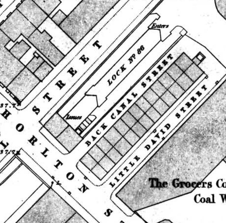
Lost and forgotten streets of Manchester ..... nu 65 the vanished 22 houses and 81 people

I can’t think anyone would mourn the disappearance of Back Canal Street and Little David Street.

In the space where two streets existed, Chorlton Street, 2016
In 1841 81 people lived in 22 of the 28 back to back properties which had been built as one up one downs at the beginning of the 19th century.

Here lived a mix of families who earned their living as labourers, textile workers with the odd craftsmen.

So few back to backs have survived that it is difficult sometimes to realize how small these properties were and how overcrowded they must have been.

Suffice to say that the width of this stone fronted building on Chorlton Street took in the combined width of Little Canal Street and the back to back houses.

The two streets in 1849
And I think we can be even more precise and calculate that the width of the street would be the distance from the edge of the brick building to right side of the doorway and what was left would be the width of the houses.

Looking at the census records for the June of 1841 reveals that some of the houses were occupied by just one person while others contained four to five people and one had nine individuals crammed in to its two rooms.*

But those with single occupants were in the minority and the general picture is one of overcrowding made worse by what appears to be the provision of only one lavatory.

The sound of young voices in Little David Street, 1841
The largest single age group were the young with 18 out of 52 in Back Camp Street under the age of 10, and 11 out of 29 in Little David Street.

All of which must have been a constant worry for parents with the canal and an arm of the canal surrounding the properties on two sides.

And it may well have been the canal which did for our 28 houses.  Maps from the 1890s show they no longer existed and the 1863 directory lists a warehouse on the site which may even have been there by the 1850s.

So a short life for those two streets.

Location; Manchester

*Census, Little David and Back Camp Streets, Enu 10, 7-8, London Road, Manchester, 1841

Pictures; the site of Little Canal and Little David Streets, 2016, from the collection of Andrew Simpson and streets in 1849, from the OS map of Manchester & Salford 1844-49 courtesy of Digital Archives Association,  http://digitalarchives.co.uk/

Monday, 29 June 2026

Lost and forgotten streets of Manchester nu 92 ...... Cannon Court

Cannon Court has tidied its act up  a lot since I first stumbled across it in 1969, soon after I arrived in Manchester.

1967
I remember it as one of those places which  was a bit shabby, rather neglected, and not much of an advert for the city.

Of course now I rather wish it was still like that given than many of the other interesting alleys, courts and narrow streets have been swept away.

The last time I was down there it was clean, tidy and less interesting than I remembered it.

But perhaps I am being a little picky and unreasonable given that visitors to the Cathedral, might just not want to pick their way past old boxes, overflowing dustbins and crates of empty bottles.

So I shall leave it you to judge, using an image of Cannon Court, pretty much as I left it in the 1960s, and today, all bright and pristine.

2017
Circa 1900
So far so good ........... and now for the correction, because I never clocked the name of the alley back in 1969, and when I revisited it this week one map called it Hanging Ditch, so I followed suit.

Only to be corrected by two people who pointed out that historically this was Cannon Court, and there on my own copy of Goads Fire Insurance was indeed the name Cannon Court.
So thank you for the two who were more vigilant than I.


Location; Cannon Court

Pictures;  Cannon Court, 1967, "Courtesy of Manchester Archives+ Town Hall Photographers' Collection", https://www.flickr.com/photos/manchesterarchiveplus/albums/72157684413651581?fbclid=IwAR0t6qAJ0-XOmfUDDqk9DJlgkcNbMlxN38CZUlHeYY4Uc45EsSMmy9C1YCk and in 2017 from the collection of Andrew Simpson, and Hanging Ditch and Cannon Court, circa 1900, from Goads Fire Insurance map, courtesy of Digital Archives Association, http://digitalarchives.co.uk/

Saturday, 20 June 2026

Lost Manchester Streets …. Nu 98 …… the one that never was

This is Sally’s Yard and it sounds like it should have been here for ever.

Or at least from when Hulme Street was cut sometime in the early 19th century.

Near by there was Frank Street, Mary Street and James Leigh Street, and plenty more, all reminders of a time when speculative builders and developers threw up small properties to house a local population who worked in the surrounding mills, timber yards and metal works.

And with a sense of their own importance named them after themselves or close family members.

So having passed Sally’s Yard a few days ago I pondered on its origins and whether I could find Sally in her alley.

I had hoped for one of those narrow dismal streets occupied by small residential dwellings in the shadow of dark and grimy textile mills, but which courtesy of the census returns would offer up a heap of life stories and maybe even our Sally.

It was a forlorn hope, for moving back through the 20th century into the middle decades of the century before our alley was just a passageway into an enclosed area which served as a storage spot for a tin works, and later a glass bottle merchants and “fancy box manufacturer”.

Of course, a Sally might have worked there but I don’t think we will ever find her.

And equally frustrating it appears the name Sally’s Yard may only date from 1995 when “Urban Splash completed their first ever transformation of an old Victorian Mill in Manchester, renovating Sally’s Yard on Hulme Street, just off Oxford Road”.*

Ah well history doesn’t always turn out the way you expect or want.

Location; Hulme Street

Picture; Sally’s Yard, 2026 from the collection of Andrew Simpson

*Manchester's newest New York style loft apartments - 25 years in the making...By Ben Brown, November 2020, 30th Manchester's Finest, https://www.manchestersfinest.com/news/manchesters-newest-new-york-style-loft-apartments-25-years-in-the-making/


When they stole the name of Little Stable Street

History has not been kind to Little Stable Street.

Looking down Salmon Street, 2023

First it stole its name some time in the 1870s and then relegated it to just a street which goes nowhere, and has had the added indignity heaped upon it of being left with only the backs of properties.

It was cut sometime between 1772 and 1793 and by the 1850s its eastern side was entirely taken up with commercial and industrial properties as was most of its western side.

Little Stables Street, 1850
Just one small stretch of the western side was occupied by some back-to-back houses and a passage way which gave access to a series of closed courts.

All of these were swept away in the 1870s to make way for the new Wholesale Fish Market, and it will have been around then that Little Stable Street became Salmon Street an act of rebranding which ranks as one of the least imaginative examples of town planning.

But long before then it had pretty much been ignored by the street directories who saw no merit in listing any of its occupants.

More recently Google Maps have invested time and a camera in recording the street.  The first visit was back in September 2012 which captured the name of George Makin and Sons Ltd at the far end of the street.

Spice Lounge, 2023
Two years later this had become the rear of Spice Lounge whose front faces out on to Shudehill at no.60. 

I can’t be sure just exactly when the restaurant opened but in the August of 2012 a sign announced its imminent opening replacing a branch of Costcutter.

In time I will go looking for George Makin and Sons Ltd and try to locate the residents of Little Stable Street in the middle decades of the 19th century, leaving me just with the red door and the mystery of what is behind it.

Back in 2012  it was the “New Union DVD and Video Shop” specializing amongst other things in  “Fantasy Adult Gifts”

Behind the red door, 2023

And now it is a red door and a mystery.

Location, Salmon Street, off Thomas Street

Pictures; Salmon Street, 2023, from the collection of Andrew Simpson, and Little Stable Street, 1850, courtesy of Digital Archives Association, http://www.digitalarchives.co.uk/


Friday, 19 June 2026

Lost and forgotten streets of Manchester nu 43 ..... the three that became two

Now anyone who knows the Salisbury will have passed James Leigh Street and its companion Cayley Street.

James Leigh Street, 2016
And I guess shed loads of commuters will pass by the two on their way up the stairs to Oxford Road Station but probably don’t give either street a second glance.

And that is a shame.

They are best approached by dropping down the slope from Oxford Road into the hollow where the Salisbury stands.

In total there were three of these narrow streets consisting of James Leigh Street, Cayley Street and Mary Street, which took in 28 small back to back properties.

And while the back to backs have long gone, the names of the people who built the houses are still there. So James Leigh, and perhaps his wife or daughter Mary left their mark as did Mr William and Mr Frank just round the corner in the streets they built.

The three streets in 1849
Usually when a name like James Leigh or Frank turn up as a street name there is more than a chance that they had a hand in either cutting the road or theirs were the properties that fronted it.

So as you do I went looking for Mr James Leigh in the Manchester Rate books and came up with a lot.

Now I can be fairly certain that the three roads post date 1819 and were there by 1849, but even so that 30 years yields up a fair few property owners called Leigh, so it will be a tedious process of elimination.

But it’s a start.

Of the three only James Leigh still exists as a place you can visit.  Cayley Street is now hidden behind a stout brown gate and Mary Street has vanished altogether.

So I shall finish with a look at the Salisbury which was originally the Tulloghgorum Tavern, a name it retained till 1895 when it became the Salisbury.

The origin of its name is obscure but there is a Scottish poem and Highland reel with the same name, and I am reliably informed that in Gaelic the word is variously spelled - Tullochgorm, Tulloch Gorm, Tulloch Gorum, Tulach Gorm. Tulach or tulloch and means a hill, hillock, knoll while Gorm is Gaelic for blue, green, or blue-green, so the meaning of the two words could be translated "blue-green hills."

All of which is way beyond me, although it is worth noting that the name of the Lass O’ Gowrie just across Oxford Street also has a Scottish connection.

I had for a while wondered about the a possible connection to Little Ireland which was just round the corner but if I have read Johnson’s map of 1819 the pub may already have been there before the that slum was aid out.

Cayley Street, 2016
Of course the license records might help but in the meantime I shall just say with certainty that the change of name is linked to the Conservative leader Lord Salisbury who formed a government in 1895.

By then most of the mean little streets had gone, cleared away by the railway company, and industry.

But it is still possible to get a sense of what it might have been like a century and a half ago.

Dop down from Oxford Street into that hollow and then as now the place is dominated by the tall railway viaduct and two of those narrow streets.

And while the back to backs have long gone, and Little Ireland is just a page in a history book at least the names of the people who built the houses are still there.

Location; Manchester

Pictures; James Leigh Street and Cayley Street, 2016 from the collection of Andrew Simpson and the surrounding area in 1849, from the OS map of Manchester & Salford, courtesy of Digital Archives Association, http://www.digitalarchives.co.uk/


Thursday, 18 June 2026

Lost and forgotten streets of Manchester nu 32 ............... Smithy Lane

Now until last week I had never explored Smithy Lane.

It is pretty easy to miss added to which it is not the most inviting of places.

But if you do wander down, it takes you to Garden Lane which is even narrower but widens out before joining St Mary’s Passage and also offers another diversion which is Dunlop Street which connects with Back South Parade.

And for those who leave the big NCP Car park these last two streets will be familiar enough.

Today the collection are pretty dismal bunch and I doubt that they were much better a century and a bit ago.

Back then Dunlop Street was called Greek Street and Garden Lane extended down as far as South Gate and at its eastern end took a sharp right past the Gas Works before joining Albert Street.

Once the gas works had gone the site became a Police Station for A Division.  The cells faced out on to Albert Street leaving only the tiny Gas Street on its eastern side as a reminder to what had once been.

I often wonder if any of those locked up for the night wandered over to the Turkish Baths on the corner of Albert Street and Back South Parade or fastened on a pint in the pub opposite.

But that and a few more tales of Smithy Lane or for another time.

Location; Manchester

Picture;; Smithy Lane, 2016 from the collection of Andrew Simpson

Wednesday, 17 June 2026

Lost and forgotten streets of Manchester nu 22 .............. Milk Street

Milk Street is one of those streets I never really noticed.  


Milk Street, 2016
It runs from Marble Street to York Street but once started at Phoenix Street.

Today there is little you can say about it.  Its only notable feature is that concrete lattice wall which hides the entrance to an underground car park, otherwise you are faced with the backs of several buildings.

Now if I dig deep enough I might be able to discover the origins of its name which might have something to do with dairies and the practice of keeping cattle in the city centre.

But if so It will predate 1793 when Milk Street was already there.

By 1850 its residents consisted of six businesses ranging from manufacturers, to a paper.

Milk Street, 1849
There were plenty of other properties including two closed courts and at the junction with York Street the Concert Tavern and the Queen’s Theatre.  The latter was swept away in 1901 for the Parr’s Bank.

And that is it.

Location; Manchester


Picture; Milk Street, 2016 from the collection of Andrew Simpson
and in 1849 from the OS for Manchester & Salford, 1842-49 courtesy of Digital Archives Association,  http://digitalarchives.co.uk/

Tuesday, 16 June 2026

Lost and forgotten streets of Manchester ......... nu 56 Reyner Street the one no one goes down

Now strictly speaking there will be a few people who might take a trip down this very narrow street which runs from Princess Street to Charlotte Street but I suspect they will be confined to bin men and the odd curious tourist.

Reyner Street off Princess Street, 1925
It just visible in this 1925 picture between the white building and the back of the Queen's Hotel.

And this street is very narrow.

Today it runs along the back of buildings, but go back a century and a bit and there were plenty of back to back houses which faced on to it.

I looked but couldn’t find a picture of the street in the collection and even that wonderful store of images from Manchester Libraries didn’t seem to have one.

The Queen's Hotel, 1904
So instead I have wandered just to the corner of Portand Street and Princess Street and to this building which backed on to Reyner Street.

It was from the middle of the 19th century a beer shop and later morphed into a full blown pub known variously as the Three Legs of Man and the Queen's Hotel.

And as the Queen’s Hotel it made it into the 20the century offering its gable end to any one of of a number of advertisers.

The billboard from 1904 offers up a mix of products still around today but with some that have long gone along with a notice for the Palace Theatre.

In the fullness of time I will go looking for when the Queen’s pulled its lasts pint and shouted last orders for the final time.

The former Queens's Hotel, 1973
I only remember the building as a newsagents but that sign announcing that it was owned by the Portland Book Shop Ltd intrigues me and I wonder if they were also the owners of that much bigger shop at the top of Oxford Street facing St Peter’s Square which also traded I think traded under the same name.

On a slow day studying in Central Ref it offered a welcome diversion, and for a while it seems to have moved down Oxford Road.

Of course I may have got this bit very wrong and no doubt will be corrected.

All of which just leaves me to reflect that I must have sat in the cafe beside the newsagents on Portland Street at some time in the 1970s.

Not that I even knew that running behind both buildings was Reyner Street which I suppose means that it was as lost to me then as it is to many others.

Location; Manchester

Pictures; Portland Street, Princess Street corner, E. G. Phipson, 1925, m04868, T. Baddeley, 1904, m04857, and H. Milligan, 1973, m05349, 
courtesy of Manchester Libraries, Information and Archives, Manchester City Council, http://images.manchester.gov.uk/index.php?session=pass

Friday, 12 June 2026

Lost and forgotten streets of Manchester nu 93 ….. under the arches at Hoyle Street

To be fair Hoyle Street is still there, running from Fairfield Street down to the Ring Road.

But I think it cuts a sad appearance, and today is best known by those seeking free car parking space and the odd fan of railway viaducts, because a  big chunk of it is covered by the brick viaducts that stretch out from Piccadilly Railway Station while the rest is bordered by open land and a few industrial units.

It is a place waiting for something to happen, and no doubt that something will be blocks of apartments and perhaps even in a new “office quarter”.

And that has been its fate for over 70 years.  

In 1950, the entire stretch from Fairfield Street to Tipping Street was devoid of any buildings save one pub, and a couple of warehouses with the ominous word “Ruins” recorded on the section by the River Medlock.*

But it hadn’t always been so.  The OS map of 1894 records a line of houses the length of Hoyle Street all the way to Tipping Street and dominated halfway down by the Britannia Brewery.  


Although strictly speaking Hoyle Street ended where the Medlock crossed underneath, as  the remaining part was New York Street.


Just when Hoyle Street was cut is still unclear.  It is absent from Johnston’s map of 1818 but is there by 1840, when a Mr. Adam Jackson was living at no 3.  He described himself as a “Teacher of Mathematics and  was listed as such in Slater’s Directory for 1855.

And he rubbed shoulders with neighbours who might equally be regarded as a cut above the average.  

These included, an engraver, a manager, a solicitor’s clerk, a Professor of Music and a “superintendent of police”.  

But it was still a mixed community and there was also a shop keeper, warehouseman, a file cutter, mechanic and cooper.

It is difficult to work out just what the properties were like, but Mr. Jackson and some of his neighbours were paying 5s a week in rent. 


At which point trying to make comparisons based on total income is fraught with difficulties, but in the 1850s  a male teacher in a National School would earn a £1 a week and female teacher 6s and manual workers might bring in more or less depending on their skills and circumstance.  So a textile worker in his 30s could command a wage of 22s 8d,  which was much better than an agricultural labourer who might be paid between  15s to 21s  a week with a few on 24s.**

Just what the 5s a week brought is also difficult to work out.  Only a few of the properties on Hoyle Street had survived into 1911, when the census return recorded the number of rooms in each house.

Most of those left consisted of 5 rooms, but some were only three.

Sadly Mr. Jackson’s house is not one of those that made it onto the 1911 census and that I think must be because it was swept away by an extension to the railway viaduct in 1905.

Leaving me just to reflect on what Mr. Jackson and his wife Margaret would have seen as they walked out of their home on a summer’s day in 1851.

Their home was in the shadow of the first railway viaduct, while opposite there was a timber yard and the Ardwick Saw Mill.


The River Medlock which flowed just a few feet away was still open to the sky, and supplied water for the Britannia Brewery and a host of factories close by which included two dye works and the Mayfield Print Works.

Of course, we will never know just what they thought of where they lived, but I am guessing it was a world away from the rural Cumberland where they had both grown up.

The incessant noise from the factories, the regular sound of railway trains passing close by, and the pervading smells from the river and various dyeworks were something I doubt they ever really came to terms with.


But that is so much historical speculation and tosh and seems a good point to close.

Pictures;  Hoyle Street Bridge, 1898, H. Entwhistle, m66779, m66778, courtesy of Manchester Libraries, Information and Archives, Manchester City Council, http://images.manchester.gov.uk/index.php?session=pass Hoyle Street in 1851, from Adshead map of Manchester 1851, courtesy of Digital Archives Association, http://digitalarchives.co.uk/ Temperance Street, Hoyle Street Junction looking towards Ardwick Station; and the River Medlock, 2020 from the collection of John Anthony Hewitt

*The Corporation Inn

**Textile workers, Frow, Edmund & Ruth, Radical Salford, Neil Richardson, Swinton,1984 page 34, and agricultural labourers, Agricultural Labourers’ Earnings, Parliamentary Papers 1861


Monday, 8 June 2026

Lost and forgotten streets of Manchester nu 24 Barton Square .......... all in a name change or two

Barton Square, 2016
Barton Square is that narrow little street that runs from Exchange Street round to St Ann Street and is dominated by Barton Arcade that 19th century shopping mall more glass than wall.

I use it quite a lot and I always let my imagination wander as I follow its twisty route but until recently I had never given much thought to its name.

Barton is obvious given the arcade, but square seemed a little odd, after all this is a street. 

I supposed there might be a connection with St Ann's Square but that seemed remote and the more I thought about it even Barton threw up a puzzle given that the arcade was built in 1870 and the street is there a century before.

So as you do I went looking at the old maps of the area and the story is as complicated as you could expect.

In the 1840s and 50s that first stretch leading to the arcade was Red Lion Street which extended  under what is now the arcade just stopping short of Deansgate with four little side streets around a small square called Barton’s Buildings.  These were accessed via an entry.

Red Lion Street & Back Square, 1851
And that almost offered up the answer, but not quite, because the rest of what we now know as Barton Square had undergone a number of name changes, from Back Square in the first half of the 19th century to Back St Ann’s Square in 1793.

So mystery solved, and with a bit more digging it should be possible using the directories to pinpoint the date it all became Barton Square which it was by 1900.

Leaving me only to record that in 1851 Red Lion was occupied by mix of professional occupation including an accountant, commission agent, stockbroker and consulting engineer while Back Square was full of small manufacturing businesses.


As for Barton's buildings these belonged to a Mr Barton and consisted of four warehouses and an office with a joint annual rental income of £305 which were occupied by George and Edward Wood who dealt in cotton and cotton waste and and Tobler Anschelf & Co listed as merchants.

Location; Manchester

Pictures; Barton Square, 2016, from the collection of Andrew Simpson, and in 1851, from Adshead’s map of Manchester, and in 1900 from Goad's Fire Insurance maps, courtesy of Digital Archives Association, http://digitalarchives.co.uk/

Saturday, 6 June 2026

Lost and forgotten streets of Manchester nu 21 .......... Parsonage Lane

Now Parsonage Lane really is one of those little side streets which grows wider as you follow it down from Deansgate to Parsonasge.


It was there by 1793 and was already fronted by a selection of properties.

Fast forward half a century and these included a textile factory, the Admiral Hatchlock which also went under the name of Parsonage House, five other properties and the entrance to a closed court.

A search for Admiral Hatchlock drew a blank although I do know that our textile factory had by 1851 become Charlton & Sons Calendar Works which by 1900 had expanded across the road.

Today the original site of the textile factory is a big red office and retail block which is home to the Liquor Store.

And that is the close you will get a to buying a drink on Parsonage Lane because our pub which was still there in 1900 has long gone.

Location; Manchester

Picture; Parsonage Lane, 2016 from Deansgate from the collection of Andrew Simpson

Friday, 5 June 2026

Lost and forgotten streets of Manchester nu 45 ......... Southern Street ....... all gone

Looking down Southern Street, 2003
This is Southern Street as it looked at the beginning of this century.

Back then some of the old late 18th century buildings were still standing and while one had become a garage
and another a printing works they were all still recognisable as houses with stories.

I remember talking to some of the men who worked in Andrew’s Garage in the centre of Southern Street along with the owners of the printing business at one end of the street and the motor bike shop at the other.

Nu 12 & 14 Southern Street, 2003
Collectively their memories spanned back into the 1950s and they formed an important part of a study I did at the time on how the area was changing.
And now that Southern Street has been transformed here is part of that piece.

“Southern Street in 1851 shows the same pattern of housing occupation as other working class parts of the city.

In many of the houses there is evidence of overcrowding and cellar occupation.

So at 3 Southern Street, 15 people are recorded there in 1851, with 5 living in the cellar, 2 in one room, 4 in another and 4 in the garret.  

Number 5 has 11 people.  Across the street number 12 &14 are now a garage.

In 1851, 7 people are listed as living in number 14.

Nu 3 & 5 Southern Street, 2003
It is easy to appreciate the degree of squeeze when you measure the size of these properties.

Put more simply when you look down Southern Street, remember that the 1851 census recorded 81 people living in this small street, which was a drop from the 200 living there a decade before.

Numbers 3 & 5 Southern Street is worth looking at in detail, as they may not be there for much longer.

The block has been bought recently and while there is some doubt about the future plans I can’t see them staying in their present state.

They were surveyed in 1993.  The houses consisted of three floors and a cellar.  

The second floor dimensions of number 3 are 22 feet 6 inches back from the front and 16 feet 4 inches from side to side. 

Number 5 varies slightly at 22 feet 2 inches by 17 feet.

Evidence for the cellar windows can still be seen but much else has undergone changes.

Looking up towards Liverpool Road, 2003
Ground and first floor windows are not original and the door to number 5 has been enlarged.

All the evidence suggests that they were built sometime around 1794.

Houses on Southern Street, Barton Street and Worsley Street are shown on a map of that year, when Liverpool Road was still called Priestner Street and terminated at Collier Street.

Street Directories record people living in them from 1795.  This fits in with what we know of the surrounding streets.

Tthe title deeds of the White Lion Inn and the Oxnoble Inn show that that six plots of land were sold in 1782 and  in 1804 the Oxnoble plot was sold again on condition that it was built upon within two years.”*

Location; Manchester

Pictures, Southern Street and Liverpool Road from the collection of Andrew Simpson

*Castlefield, Andrew Simpson, 2003