Showing posts with label Royton Street. Show all posts

Sunday, 18 January 2026

Lost stories in a forgotten street ……. the one behind Deansgate

Now it is easy to shudder and feel outrage at the accounts of housing conditions in the poor parts of Manchester in the first half of the 19th century.

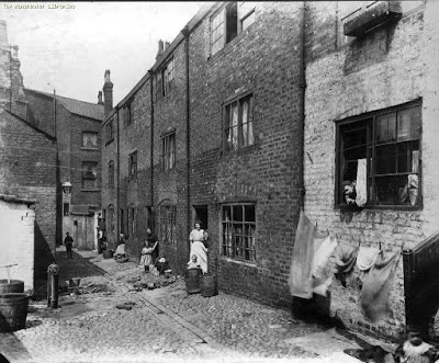
New Gates, Manchester,  1908
Overcrowding, back-to-back houses, closed courts where the sun fought to penetrate, and of course a lack of sanitation matched only by parts of the developing world are the stuff of social history.

But the history books and rarely the social observers of the time burrowed deep to offer up the personal stories of those who lived in the cellar dwellings and the one up one down properties, often built in the shadow of textile mills, and iron foundries and bounded by the polluted rivers that ran through the city.  

Dr Kay, Frederick Engels and a few foreign visitors did paint a grim picture.

And more revealing is the case notes of Dr Henry Gaulter who experienced the first outbreak of Cholera during the May to December of 1832. 

He kept a detailed record of the first three hundred patients he attended describing their physical condition, the onset of the disease and their living conditions but was forced to abandon the exercise as the numbers increased.*

Royton Street, 1851
So, with that in mind I have plunged back into one street off Deansgate in 1851.  In that year it was home to 408 people who lived in 46 houses, nine of which were one roomed back-to-back properties, and the remainder, consisted of four rooms with weekly rents ranging from 1 shilling [5p] to 5s [25p].

The street was Royton Street, and history has not been kind to it.  It never featured in any of the street directories for the 19th century, and progressively lost its houses and half its length to industrial development and finally vanished under the Spinnyfields project at the start of this century.

There are only two photographs of it in the City’s digital collection, and one of those I think has either been misplaced from somewhere else or is much older than the published date.**

I came across the place by chance a few days ago, wrote about it and planned to move on but the detail is as they say in the detail and so I trawled the 20 pages of the 1851 census and then went back for some of the surrounding closed courts.***

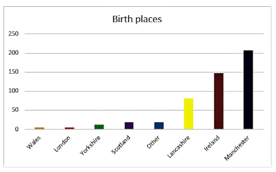
One bit of detail was the presence of a Catholic day and Sunday school in the middle of the street, which made perfect sense given that 36% of the street’s residents were born in Ireland and a cursory look at the surrounding area suggest that this was typical.

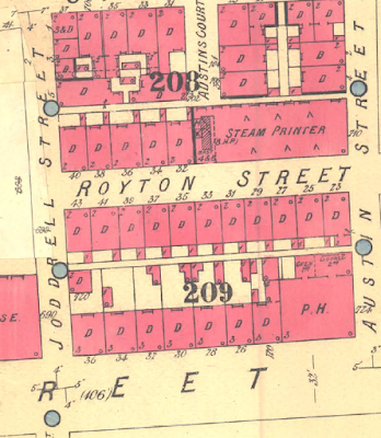
Royton Street, circa 1880-1900
Nor would the Irish accent be the only one you could hear, for while 50% were from Manchester, there were significant numbers of residents from Scotland, Wales, Yorkshire, as well other parts of Lancashire, seven from London, nine from Cheshire, and even one from Prussia.

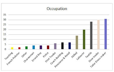
Their occupations were as varied as their origins, with a mix of textile workers, four policemen, an architect’s apprentice, and two teachers.

And there were the usual range of skilled trades from carpenters, painters, and glaziers to those engaged in the book and shoe trades, as well as tailors, dress makers, a blacksmith, oastler, and “brick setters.” 

But we are in one of the poorer areas of the city, and so here were labourers, house servants, and those on pensions, and poor relief.

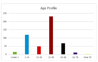
To which we can add children, for over a third of the street were young people under the age of 15, and while plenty of these were attending school others by the age of 11, were employed as errand boys, apprentices, and servants.

Birth places of Royton Street residents, 1851
The census also records the degree of overcrowding, so our 408 inhabitants lived in just 46 houses made up of 89 households.  

Nor does this deliver the true degree of overcrowding.  So picking just three houses, which were numbers one, three, and four, together they were home to 38 people.  

At number one there were 18, divided into three households, at number three, eight divided into two households, and at number four there were 12 living in three households.

It is a picture replicated across the entire street, and while there were some big families, there were also many lodgers.  In total the figure was 72, most of whom were unmarried, were not related, and were occupied in a variety of skilled and non-skilled occupations.  

Of the 72, only 11% were from Manchester, with the rest drawn from all parts of the country, with 43% from Ireland.

Age Profile of Royton Street residents, 1851

Almost every household included some lodgers, and while there were a few “lodging houses” most families shared their home with people they were unrelated to.

All of which raises the question of how big the houses were.  

There were 14 back to back properties which might have had three rooms but equally might have had just two, and the census return is silent on the total number of rooms for these or the remaining houses.  

The surviving properties listed in 1901 indicate that they consisted of four rooms, but by then there were only 14 left which leaves the other 32 a mystery.

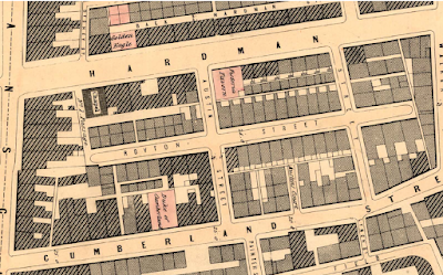
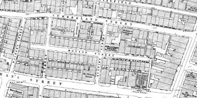
Royton Street, 1849
Nor it appears were there any cellars, recorded on the 1851 census.  Now cellar dwellings do show up for other parts of the city, and people are recorded as living in them, so it seems Royton Street was cellar free, or at least, from cellar occupants.

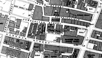
For the curious Royton Street was located between Hardman and Cumberland Streets and its course roughly follows the route of the Avenue in Spinneyfields

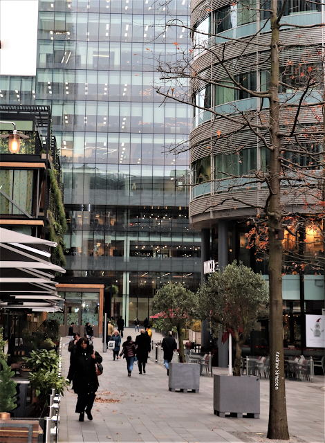
In the vicinity of Royton Street, Spinningfields, 2020

Occupations of Royton Street residents, 1851
Next, I have a fancy to explore some of the families and try to delve into what their lives were like.

Location; Off Deansgate, Manchester

Pictures; New Gates, 1908, m8316,  courtesy of Manchester Libraries, Information and Archives, Manchester City Council, http://images.manchester.gov.uk/index.php?session=pass, Spinneyfields, 2020, from  the collection of Andrew Simpson and Royton Street in 1849, from the OS map of Manchester and Salford, 1844-49, and Royton Street circa 1880-1900 from Goad's Fire Insurance maps, courtesy of Digital Archives, http://digitalarchives.co.uk/and Royton Street 1951, from the OS map of Manchester and Salford

All that was left, 1951

*Gaultier Henry, The Origin and Progress of the Malignant Cholera, 1833, London, & Appendix A, To the Report of the General Board of Health on the Epidemic Cholera of 1848 & 1849, 1850, London

**Royton Street, Manchester Libraries, Information and Archives, Manchester City, http://images.manchester.gov.uk/index.php?session=pass

***Lost and forgotten streets of Manchester .......... nu 95 Royton Street, 1951 https://chorltonhistory.blogspot.com/2022/02/lost-and-forgotten-streets-of.html 

Thursday, 12 June 2025

Lost and forgotten streets of Manchester .......... nu 95 Royton Street ...

 You won’t find Royton Street.

Spinningfields, 2020

It vanished long ago under the Spinneyfields development but for a century and more it lay between Hardman Street and Cumberland Street.

Not that you would have found it that easily, because it was one of those closed streets shut off by two narrow passages which gave off to more closed courts.  The curious or those in the know could access it by one of two streets which ran between Hardman and Cumberland Streets of which only one had been given a name.

Royton Street, 1849
To add to its obscurity, it failed to get into any of the street directories during the 19th century, but it did boast the St Mary’s Roman Catholic Chapel School.

But in 1851 it was home to 399 people who lived in 39 houses, nine of which were one roomed back-to-back properties, and the remainder, consisted of four rooms with weekly rents ranging from 1 shilling [5p] to 5s [25p].

Their occupations included textile workers, laboures, retired soldiers, a sailor, a French polisher and an architect’s assistant.  Added to these there were a number of skilled artisans including a group of “shoe makers” a tailor, a “Gold Beater” and “Cabinet maker”.

The east side of Royton Street, circa 1880-1900
During the course of the 19th century some of houses were replaced by industrial units, including two steam printers and a paper warehouse, so that by 1951, the western side of the street had been swallowed up by another printing press and all the houses along the entire length of the street had gone.

I can’t be sure when Royton Street was cut, but the first reference to it in the Rate Books is 1828, although there is a suggestion that it might have already been there by 1819.

It has yet to pass out of living memory and I am sure I will have known it, but with the passage of over 53 years these narrow streets off the beaten track were places you found by accident and didn’t always return to.

Today the closest I think the inquisitive will get to walking its length will be along the Avenue which runs down from Deansgate, past Spinningfields Square finishing in front of Manchester Crown Court.

The Avenue, 2020
On a pleasant day the shops, bars and restaurants which flank the Avenue on both sides attract plenty of passersby but perhaps not as many as the developers expected.  

Still the swish retail outlets and the swanky eating places are a long way from the Royton Street of the 1850s.

But I am drawn to that earlier place, partly because of the wealth of information about its inhabitants which shed light on how we lived 170 years ago in this part of the city, but also because there is a personal link.  

It is not me, but a Facebook friend whose family were on Royton Street from at least 1851 for two decades, and continued to live in the area up into the middle of the last century.

Royton Street, 1951
Alan Jennings who introduced me to his ancestors has written a vivid account of their lives, and in particular those who served during the Revolutionary and Napoleonic Wars through to the Great War, and Alan’s own service with the Colours.

Now that is the story of personal history I like.

Location; Manchester

Pictures;  Hardman Street, and the Avenue, 2020, from  the collection of Andrew Simpson and Royton Street in 1849, from the OS map of Manchester and Salford, 1844-49, and Royton Street circa 1880-1900 from Goad's Fire Insurance maps, courtesy of Digital Archives, http://digitalarchives.co.uk/and Royton Street 1951, from the OS map of Manchester and Salford

Tuesday, 16 May 2023

Discovering the forgotten

I don’t suppose Charles Taylor or his wife Ann would have been much surprised that their home has not survived.

Taylor's Court, 1849

In 1851 they were living in Taylor’s Court which was one of those tiny places sandwiched between other streets.   All our towns and cities had their share of these courts which were often a byproduct of in filling where a builder or speculator fell on an open space and built a few houses for rent.

In the case of Taylor’s Court there were just five such houses which were accessed through two narrow passages.  The properties commanded rents of 2/3d which were not the cheapest rents in the area but not far off.  I can’t be sure of the size of the five houses, but they show up on maps of the period as back to backs, so it is most likely that they were one up one downs.

And like other streets in the immediate vicinity there was a degree of overcrowding.  So, while in four of the houses the number of inhabitants ranged from 2 to four people, at number 1 the Taylor’s squeezed a total of six family members and a lodger their home.

The occupations of the residents were typical of the area, and included those who worked in textiles, shoe and dress making, and others engaged as labourers and launderesses.

Taylor's Court and surrounding streets, 1849

Their origins were equally mixed, with 5 of the 20 having been born in Ireland and the rest from Manchester, Cheshire, Cumberland, and Scotland.

But at least they could give an address, which was more than could be said of the Holland and Horan families who lived in the narrow passage which gave access to Taylor’s Court.  The census records their address as Stock’s Court but on maps of the period it appears as No. 1 Passage, and in the Rate Books, as just a Court attached to the list of properties on Royton Street and are not recorded in any of the street directories.

Taylor's Court moves, circa 1900

I have no idea when Taylor’s Court vanished but Goad’s Insurance maps, which cover the last two decades of the 19th century show them still in place, but the passageway has been renamed Taylor’s Court, and the original location has lost its houses and its length is described as “Wood Hoardings 40’ high. 

The remnants my have lingered on, but by 1951 it and the eastern side of Royton Street had been subsumed by industrial units. 

And just as the properties have faded so have the residents of the two courts, and despite a trawl of the census returns I have only been able to trace two.  In 1841 Charles Taylor was living in the Deansgate area, but after 1851 has so far disappeared from the official records.

The search for Thomas Holland has proved a tad more successful.  I know he was from Cheshire and that his younger brother farmed over 200 acres.

In 1841 he was still living with his family but ten years later he was in Stocks Court where he was renting the house and a workshop.  In both the census for that year and the street directories he gave his occupation as Whitesmith which my Wikipedia describes as “a metalworker who does finishing work on iron and steel such as filing, lathing, burnishing or polishing. The term also refers to a person who works with "white" or light-coloured metals, and is sometimes used as a synonym for tinsmith”*

All gone, 1951

A decade later he and his wife were on Shaw Street in Salford, still working as a Whitesmith, on a street which appears to be only a marginal step up from that Court off Deansgate.

All of which is a little confusing, given that on the 1871 census while visiting his brother he describes himself as “gentleman”, which only adds to the mystery of his birthplace, which on all the official documents is different.

Of course we maybe dealing with different men, but the other details of occupation, wife and age all would suggest we are dealing with the same man, and I doubt I will resolve the confusion.

Location; Manchester, Salford and Cheshire

Pictures; Royton Street in 1849, from the OS map of Manchester and Salford, 1844-49, and Royton Street circa 1880-1900 from Goad's Fire Insurance maps, courtesy of Digital Archives, http://digitalarchives.co.uk/and Royton Street 1951, from the OS map of Manchester and Salford

*Whitesmith, https://en.wikipedia.org/wiki/Whitesmith