Showing posts with label Chorlton on Medlock. Show all posts

Sunday, 20 July 2025

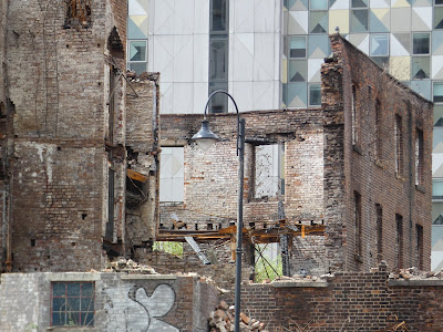
Goodbye the Hotspur Press … only the demolition team and Andy Robertson think of you……

 Well of course that is not strictly accurate.

There are others interested in the building who keep coming down since the fire to photograph the sad sight of what’s left.

But there aren’t many.  The media, and TV pundits, have moved on to pop concerts, and road closures.

While the conspiracy theorists no longer cast the dice on who was to blame, how had the story first broken on a Chinese news station 24 hours earlier and had the building really been consumed by flames, and instead return to stories of visitors from outer space building the pyramids.


Not my old chum Andy Robertson who was back on Friday with camera in hand to explore what was going on.


As ever he is creating a collection of pictures which will chronicle the end of the building and whatever the developers have in mind for the site.

So here are his latest images which reveal the bits inside which most never see from Cambridge Street, along with the effects of the fire on timber, stone and wood.

And I finish with a picture almost the same as the first, but which offers us that chair just beyond the fence.

I may be wrong but that chair or a similar one seems to have sat there for as long as I can remember, long before the fire and long before the high-rise developments along Cambridge Street.

Well I may be wrong …. Someone I am sure will have an opinion, and perhaps come up with some photographs of the site of their own.

We shall see.

Location; Cambridge Street


Pictures; Friday on Cambridge Street at the Hotspur Press site, 2025, from the collection of Andy Robertson

Monday, 23 October 2023

Lost and forgotten streets of Manchester ........ nu 91 .........Higher Temple Street

You won’t find Higher Temple Street.

It went in the clearance of 19th century houses which also did for the surrounding network of streets in this bit of  Chorlton on Medlock.

But I have found it on the old maps, and so know it ran south from Rusholme Road down to Brunswick Street.

Back at the beginning of the last century there were 86 properties on Higher Temple Street, ranging from shops to houses, the odd industrial site and the HQ of the local Conservative Association.

By 1959, when the picture was taken some of those buildings had gone, and judging by the boarded-up shop, these properties would also soon be gone.

That said, despite the grand plan, the newsagents clings on, still no doubt dispensing, newspapers, cigarettes and ice cream to any one left to buy them.


Location; Chorlton-on-Medlock

Picture; Higher Temple Street, 1959, "Courtesy of Manchester Archives+ Town Hall Photographers' Collection", https://www.flickr.com/photos/manchesterarchiveplus/albums/72157684413651581?fbclid=IwAR0t6qAJ0-XOmfUDDqk9DJlgkcNbMlxN38CZUlHeYY4Uc45EsSMmy9C1YCk 

Tuesday, 30 November 2021

The lost houses of Princess Street begin to reveal their secrets

Now you won’t find these two properties.

Brook Street as was
Once and for a very long time  they stood with a collection of similar buildings just down from Charles Street on Princess Street.

They vanished sometime between May 2011 and September 2012 and all that remains is the outline of the roof on the neighbouring building and a fine view across the vacant space to the skyline of Oxford Road.

They were so much a part of the landscape that like many I took them for granted and gave little thought about their history.

If pushed I suppose I did wonder about the people who might have lived in them.

The rear of Brook Street
But at a time when access to rate books, census returns and old maps was more difficult the chances of personalising these properties was beyond me but all things change and today it  is much easier  explore a street or a house and so it is with these.

They will postdate 1819 and were well established when the surveyors of the Manchester and Salford OS map completed their task in 1849.

Two years later Slater’s directory recorded the residents of the row and Mr Adshead featured them on his colour map.

All of which means  I can confirm that along the stretch there were a motley collection of businesses and householders, from James Carruthers beer retailer and Lydia Dodson, tobacconist to Edward Hooper of the Medlock Inn.

In total there were twelve buildings running down to the Brook Street Bridge from Charles Street which neatly brings me to the fact that back in 1851 the bridge and our houses stood on Brook Street rather than Princess Street.

Brook Street, 1851
At which point I could have gone off and explored the rate books where the details of Mr Carruthers beer shop are listed but instead I will just reflect on just how much easier it is today to research properties like these.

Starting with the maps and then the directories it is possible to locate an individual householder, and armed with a name find them on the rate books and census returns.

The rate books will tell you not only the rateable value and the annual rent but whether the householder was a tenant or the owner along with what the building was used for.

And the name will also offer up the possibilities of finding them on the census return which will reveal their occupation, date of birth and their family.

That said the census return for Mr Carruthers has been badly damaged, but I travel in hope that some of the others on the stretch will come to light.

The rear after the demolition, 2014
We shall see.

For now I have Ray Ogden to to thank for finding the two images and Mike Peel who gave permission to use what are two of his photographs.

And in\turn a thank you to Nick Rusthon who took this picture of the rear of the two houses after they had been demolished.

I like the detail of the original stone work with the brick of the two houses above.

Detail of the rear wall

I am guessing that the stonework will predate the properties.

The small aperture in the brickwork might suggest that the building had cellars which were common enough but now I am not sure given the height from the stonework to the street level.

But then I am no experts so I shall leave it to others to make a judgement.

And instead finish with another image of the site.  

This time from my old chum Andy Robertson, who has created a huge collection of pictures which record the transformation of the twin cities of Manchester and Salford, and across Greater Manchester.


This was was taken earlier this month and captures the space which was our houses.

Location; Manchester

Picture; Princess Street, date unknown, courtesy of Mike Peel,  (http://www.mikepeel.net/)    under CC BY-SA 4.0 (http://creativecommons.org/licenses/by-sa/4.0/)  rear of the properties from the collection of Nick Rushton, 2014, the space, 2021, from the collection of Andy Robertson,  and map of the area, from Adhead's map of Manchester 1851, courtesy of Digital Archives Association,  http://digitalarchives.co.uk/

Friday, 26 November 2021

Looking down at the River Medlock..... and thinking of lost streets

 Now, I thought this was one of those straightforward stories.

The Medlock from Brancaster Road, 2021

Andy’s picture of the River Medlock, offered up another river story.  

It was taken from Brancaster Road, which connects Oxford Road with Princess Road.

But that was before I got lost in tracking Brancaster Road back into the past and coming to the conclusion that the road doesn’t have a past.

It looks to have been cut sometime between March and May 2017 during the redevelopment of the old BBC building which occupied the site between Oxford Road and Princess Street.

The BBC opened their flagship building in 1975, and its construction led to the elimination of a network of streets which had been home to rows of terraced houses, a school and church and a number of factories and warehouses including the Medlock Works which made rubber footwear.

The area in 1844

These survived the Blitz, were still there in 1950, but following a compulsory purchase order, in 1967 and following clearance of the site, building began in 1971.

By then most of these lost streets were nearing their 150th birthday.

Charles Street which is on the edge of the site looks to have been cut in 1822, and with a bit more research in the Rate Books we should be able to date the collection of streets which were cleared away.

By the 1850s Charles Street could boast five beer shops, one pub called the George IV, and 27 properties which were home to a varied group of people, from shop keepers to craftsmen and a screw manufacturer, and an engraver to a firm of calico printers.

Who did what on Charles Street, 1851
And yes by 1844, the Lass ‘ Gowrie was trading under its name.

In time I will go looking for the rest of the streets and search out the occupations of the residents.

Which leads me back to Andy’s picture. 

Had he stood on the same spot back in 2015 he would have been in the car park of the BBC, 65 years earlier and it would have that rubber footwear factory, and stretching back a century the site was a timber yard.

The Medlock goes dark, 2021

Which just leaves another picture of the Medlock as it disappears into the dark, thereby fulfilling my promise of a river story.

Location; Chorlton-upon-Medlock

Pictures; by the River Medlock in Chorlton-Upon- Medlock, 2021, from the collection of Andy Robertson, and the same spot in 1844, from the OS map of Manchester & Salford, courtesy of Digital Archives Association,  http://www.digitalarchives.co.uk/ 


Friday, 27 November 2020

Africa United in Manchester .... on the wireless today

Now here is one to listen to.


"Shortly after the end of World War II, a conference was held in Manchester which helped redefine racial equality, identity, and notions of independence within British colonies around the world.

At the time, soldiers were still being de-mobbed, Prisoners of War were returning from the Far East and a new Labour Government was promising to rebuild Britain. But in October 1945, 200 delegates from across Africa, the Caribbean, the United States and Britain came together in the modest surroundings of Chorlton-On-Medlock Town Hall on Grosvenor Street, just south of Manchester city centre.

A week of debates included how African and Caribbean nations could best achieve independence from their colonial masters, what was to be done about enforced child labour and poor wages on the sugar-cane plantations in the Caribbean, and how to deal with the rising mixed race population in Cardiff.

Taking part were some of the most influential black thinkers of the time, including W E B Du Bois, affectionately known as the father of Pan-Africanism and among the delegates were three men who would go onto lead their respective countries to independence - Kwame Nkrumah (Ghana), Jomo Kenyatta (Kenya) and Hastings Banda (Malawi).

'Reading the transcripts of the debates, it’s clear that it was a galvanising event', says Rosemary Laryea. 'There are huge similarities between the demands of the delegates in 1945 and the rallying cries of the current global Black Lives Matter movement.'

Presenter: Rosemary Laryea

Producers: Rosemary Laryea and David Prest

A Whistledown production for BBC Radio 4"

Location; Chorlton on Medlock

Picture; Chorlton on Medlock Town Hall, 1972, m52112, courtesy of Manchester Libraries, Information and Archives, Manchester City Council, http://images.manchester.gov.uk/index.php?session=pass

*Africa United in Manchester, Radio 4, https://www.bbc.co.uk/programmes/m000ptb5


Friday, 29 September 2017

Discovering more of that building on Cambridge Street

Now the Hotspur Press building has attracted more than its fair share of photographs.

I noticed that some sell for over £100 a copy which I suppose reflects its history, which started a cotton mill, became a print shop run by the Percy Brothers and closed in 2011.

Andy Robertson took a trip round the building and discovered some of its more interesting past, like the Medlock which flows past this old mill.

Today it is surrounded by flat conversions which were home to factories and warehouses and which stand beside tall 21st century developments.

There will be someone who has an up to the minute take on the future of his old building, and I should have gone looking at the planning portal for the city but instead I will leave that to someone else.

And who knows we might get a score of stories of those who worked there or just remember tales from its long history.

I hope so.


Either way, Andy's short series of the place is a welcome addition to the collection on the building and of course his own portfolio of images of our industrial past.

Location; Chorltonon Medlock


Picture; from the Hotspur Press series, 2017 from the collection of Andy Robertson

Thursday, 28 September 2017

That building on Cambridge Street

Now the Hotspur Press building has attracted more than its fair share of photographs.

I noticed that some sell for over £100 a copy which I suppose reflects its history, which started as a cotton mill, became a print shop, run by the Percy Brothers and closed in 2011.

I could say more but instead will turn Andy Robertson’s pictures into a short new series.

And despite my entreaties to do so Andy has yet to put a price on his work.

I think he should.

Location; Chorlton0n Medlock


Picture; from the Hotspur Press series, 2017 from the collection of Andy Robertson

Monday, 30 May 2016

Walking through Chorlton on Medlock with a church procession

Now I don’t have a date for this church procession or exactly where in Chorlton on Medlock it took place.*

It was taken by Harry Wright who had a photographic studio at 27 Eston Street which was off High Street which ran from Plymouth Grove to Oxford Street.

It is still there but High Street is now Hathersage Road and the photographic studio long gone.

Sadly no one seems to have judged Eston Street worthy of a picture and the only two in the digital archive show just the corner.

But I am hoping that someone will recognise the street scene and perhaps even offer a date.

And perhaps that shop and the advert beside the Brook Bond sign will help.


We shall see.

Location; Chorltonon Medlock

Picture;Chorlton on Medlock, date unknown from the collection of David Harrop

*Manchester Whit Walks, https://chorltonhistory.blogspot.co.uk/search/label/Manchester%20Whit%20Walks

** Manchester Local Image Collection, http://images.manchester.gov.uk/web/objects/common/webmedia.php?irn=36700&reftable=ecatalogue&refirn=30483