Showing posts with label The Duke's Canal. Show all posts

Sunday, 5 November 2023

The mystery cuts in stone at the end of the Old Road ........ walking Chorlton in the 1760s

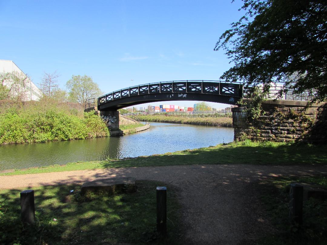
Now anyone who walks the Old Road which meanders on the edge of Turn Moss will know that eventually you will reach the Cut Hole Aqueduct which takes the Duke's Canal over the Kickety Brook.

The mark of the mason, circa 1760s
The aqueduct was built in the 1760s and any one taking the Old Road would have gone under its arches on their way to Stretford, ending up at the Cock Inn and the Pump.

At which point I have to confess that the Old Road is my name for what has variously been known as Hawthorn Lane and Back Lane, but given that this is a very old thoroughfare I shall continue to call it the Old Road.

What I had never spotted on the stonework were the mason’s marks, which have a history going back beyond the Middle Ages.

Left in stone, circa 1760s
I have no idea just what they mean, but I know someone will, and my fascination is shared by my old friend David Bishop who photographed them and passed them onto me.

And never one to miss an opportunity of a story here they are.

David has promised me more and I wait with impatience.

Of course given all the controversy “over that plan” for Turn Moss I rather think plenty of people will also be interested.

The Old Road and aqueduct, 1854
All of which leaves me to add this 1854  map of the Old Road as it reaches the aqueduct, pointing also to the weir which was built in the 18th century to slow down flood water from the Mersey flowing fast to the Duke’s Canal and damaging it.

The weir was badly damaged in the 1840s and had to be rebuilt, after which it continued to protect the aqueduct and the canal until the last serious flood in 1915.

Location; The Old Road

Pictures; mason’s marks on the stone of Cut Hole Aqueduct, 2018 courtesy of David Bishop, and the Old Road from the 1854 OS for Lancashire, courtesy of Digital Archives Association, http://digitalarchives.co.uk/

Tuesday, 28 February 2023

Picking up the packet boat from Stretford and then post haste to Castlefield on the Duke’s Canal


Packet boat charges on the Duke's Canal 1841
Now I often write about living in the township in the mid 19th century and I reckon if I had wanted to travel into Manchester it would have been by water.

So if I could have afforded it I would have chosen one of the twice daily package boats from Stretford along the canal which transported passengers in comfort and speed.

A ticket for the front room cost 6d [2½p] and the back room 4d [1½p].*

This was travelling in style.   These packet boats were fitted with large deck cabins surrounded by windows which allowed the passengers to sit “under cover and see the country” glide by at the rate of six miles an hour, made possible by  two or sometimes three horses which pulled the packet.  And if that was not style enough the lead horse was guided by a horseman in full company livery.**

It was a pleasant enough journey for most of the route was still across open farm land and it was not till Cornbrook that the landscape became more industrial.

From here on there was no mistaking that the final destination was that busy, smoky and energetic city.  The chemical and dye works of Cornbrook gave way to saw mills, a textile factory, paper mill and all manner of wharves and ware houses before the packet arrived in the heart of Castlefield.

But we all know that I wouldn’t have been in the money and so there would have been no fast packet boat for me and no walk out of the village along the old road to Stretford, instead it would have been a longer and slower tramp, north through Martledge.  But that is another story for another time.

Location; Stretford, Trafford

Pictures; Packet boat charges from Pigot and Slater’s Directory of Manchester and Salford 1841, and detail of the Cornbrook stretch of the Duke’s canal from the OS map of Lancashire, 1841-53, courtesy of Digital Archives, http://digitalarchives.co.uk/

*This was beyond what most of our residents could afford.  A domestic servant might earn 2s 9d [13½] while that of a labourer was 13s.6d [57½p].

**Slugg, T.J., Reminiscences of Manchester, J.E.Cornish, Manchester 1881, Page 223

Wednesday, 15 February 2023

Memories of the Duke's Canal at Stretford

The Duke's Canal from Stretford, 1830
Now if you don’t live near a river I reckon a busy canal is the next best thing.

And of course Stretford has both.

Not that that this will be one of those trips back to a rosy view of the past.  Working waterways like the Thames where I grew up were noisy dangerous and often smelly places, but they were also busy, exciting and held out the promise of adventures.

Now in the case of the Duke’s Canal that pretty much meant Manchester which for a young lad who knew only the lanes and farms of Chorlton or Stretford would have been a beacon of opportunity and mystery.

And if that lad travelled along the canal to the Duke’s Quay there is no doubt that he would have been as impressed as one unknown tourist from Worcestershire who recorded in his diary in 1792 that

“There’s such Quantities of Slate, Timber, Stone & Merchandize of all sorts.  The warehouses are very Extensive, but they are Pretty will filled with one thing or other.  There’s not less than 30 or 40 Thousand Bushels of Corn in them at this time and large Quantities of flour &c.*

Paying for the journey in 1841
Fast forward just forty years and if you could have afforded it the canal was still the quickest and most comfortable way of travelling into Manchester.

So if I could have afforded it I would have chosen one of the twice daily package boats from Stretford along the canal which transported passengers in comfort and speed.

A ticket for the front room cost 6d [2½p] and the back room 4d [1½p].*

This was travelling in style.   These packet boats were fitted with large deck cabins surrounded by windows which allowed the passengers to sit “under cover and see the country” glide by at the rate of six miles an hour, made possible by  two or sometimes three horses which pulled the packet.  And if that was not style enough the lead horse was guided by a horseman in full company livery.**

It was a pleasant enough journey for most of the route was still across open farm land and it was not till Cornbrook that the landscape became more industrial.

Along the Duke's Canal in 1850
From here on there was no mistaking that the final destination was that busy, smoky and energetic city.

The chemical and dye works of Cornbrook gave way to saw mills, a textile factory, paper mill and all manner of wharves and ware houses before the packet arrived in the heart of Castlefield.

But we all know that I wouldn’t have been in the money and so there would have been no fast packet boat for me and no walk out of the village along the old road to Stretford, instead it would have been a longer and slower tramp, north through Martledge.

But that is another story for another time.

Instead for tomorrow more memories of the canal and boat building.

Pictures; Packet boat charges from Pigot and Slater’s Directory of Manchester and Salford 1841, and extract from Bradshaw's The Inland Navigation of England and Wales, 1830 and  detail of the Cornbrook stretch of the Duke’s canal from the OS map of Lancashire, 1841-53, courtesy of Digital Archives Association, http://www.digitalarchives.co.uk/

*Lancashire in 1792, A Tourist’s Diary, To Liverpool by Canal, Ships in the Streets, Manchester Guardian July 17, 1936

Thursday, 7 April 2022

The day I thought I was in the country …… urban tales from Chorlton-cum-Hardy

Now, the purist will immediately point out I was not in Chorlton nor the countryside.


But on a hot summer’s day sometime at the end of the 1970s I rather thought I was.

I had taken myself off across the meadows and discovered the old weir at that bend in the Mersey.

The weir had been built in the 18th century to break the force of a flood surge which might have damaged the aqueduct carrying the Duke’s Canal.

The river regularly flooded in earlier centuries and once in the 1840s the force of that surge was so strong it damaged the weir itself.

Even now the base of the weir can still be marshy and after a wet winter the water will stretch out into the surrounding land.

On the day I discovered the spot there was just a hint of water but enough for the cows who grazed on the grass.

And it was the cows, the pasture and the steeple that offered up the illusion of somewhere rural.

Although I did have to frame the picture to miss the tower block and get the chapel of Stretford Cemetery in the centre.*

And before any one sneers, .... yes the quality of the pictures was poor.  In my defence I was just beginning to develop and print images using smelly photography and the negatives have sat in our cellar for over 40 years.

Location; the meadows west of the Mersey, circa 1978, from the collection of Andrew Simpson

*Stretford Cemetery, https://www.trafford.gov.uk/residents/births-deaths-and-marriages/burials-and-cremations/cemeteries-and-crematoria-in-Trafford/stretford-cemetery.aspx


Friday, 18 June 2021

Travels with the Kickety Brook ………..

 If there is one thing all the guides agree on, it's if you walk the Kickety Brook out beyond Chorlton  you should wear wellies.


“Access is off Hawthorn Lane, or Chester Road, Stretford. Popular with walkers, cyclists and horse riders alike. Be sure to wear boots or wellingtons if you are on foot. 

The path goes through a good mix of habitats for spotting a wide range of wildlife”.*

 I first came across the brook while researching the weir by the Mersey, which had been built to protect the Duke’s Canal in the 18th century and rebuilt in the 1840s after it had been damaged by flood water from the river.

 With that spectacular disregard for the environment the engineers constructing the Bridgewater Canal had commandeered the Kickety Brook to act as a channel for possible flood water from the weir, thereby reducing the surge of water and protecting the canal.


Over a decade ago I walked the short section of the Brook with my old botanist pal, David Bishop, following its path down under the motorway.

 And this week Andy Robertson walked the same walk and took a series of pictures which testify to the advice on suitable foot wear.

 I remember that back in the 1970s the stretch of land in front of the weir often appeared to be dried out but more recently there has been a significant pool of water stretching back from the stone wall.

That said the last time the weir saw action was back in 1915 which I guess would have meant that the Kickety Brook took the overflow off the fields in front of the canal.


Since then the Brook has been tampered with again and the bit under the motorway has been forced into a concrete channel.

 But the Brook and nature do not easily recognise such a attempts to fiddle with it, and lumps of the artificial channel have suffered over time, while the surrounding vegetation threatens to soften and hide  the work of the motorway engineers.

After a bout of rain, stretches of the Kickety can still look like a respectable water course, but suddenly it becomes just a muddy, shallow and sluggish reminder of its former self.


It always amazes me how with in just a few yards the Brook can undergo such a transformation.

So I am grateful to Andy for capturing the different sides of Kickety in what was a warm early summer's day.

Just whether he chooses wellies, stout walking boots or trainers has yet to be revealed, but I hope he didn't get his feet wet in the process of revealing this stretch of water.

Leaving me to hope his pictures will spark a flood of memories from people who payed along it in their youth or who once explored it's route.

We shall see.


As the guide* suggests the brook can be approached down Hawthorn Lane, where it goes underneath the Cut Hole Aqueduct.

 But for those that prefer their stretches of water broader and deeper, the aqueduct gives access to the canal and the tow path from which the serious walker can head off in one direction towards town or out to Sale, Timperley and rural Cheshire.

And yes, on my trip with David, once we had passed under the motorway and left the noise of speeding traffic, the seemingly remoteness of the route presented us with other sounds, from the occasional bird, to the lazy buzz of bees, and the sights of the odd butterfly.

 Location; The Kickety Brook

 Pictures; the Kickety Brook, 2021, from the collection of Andy Robertson

*Mersey Valley Kickety Brook, Stretford, Things to do in Manchester, https://www.visitmanchester.com/things-to-see-and-do/searchresults?sr=1&name=kickety+brook

Friday, 11 June 2021

Just what you find on the way to Lymm ……..

I won’t be alone in collecting old canal warehouses.

The warehouse, 2021

They were during the 18th and early 19th century at the cutting edge of design, and were later copied by the first railway companies as the template for warehouse design.

They were created to solve the need to tranship goods from canal to road, and road to canal, and consisted of entrances on both sides from which produce could be brought into the warehouse and stored for onward shipment. 

These entrances were known as loop-holes and were supplemented by large arches at water level which allowed boats to enter the building.

The warehouse, coal year, wharf, 1900 

So I was more than pleased that on Andy’s adventure to Lymm, he took a slight detour and ended y past Warrington Lane and took the pictures of the warehouse which sits beside the Duke’s canal.

The site has changed very little in the last 150 years, and if I had access to maps from the late 18th and early 19th centuries I am sure they would show the same.

And that pretty much is that, other than to say I will go looking for any plans for the redevelopment of the warehouse.

Location, on the Bridgewater Canal,

Picture; the warehouse, 2021, from the collection of Andy Robertson, and the site in 1900, from theOS map of Cheshire, 1900courtesy of Digital Archives Associationhttps://digitalarchives.co.uk/

Saturday, 14 November 2020

Rural walks in an industrial setting ………….. walking the Duke’s Canal at Watersmeeting

There is no doubting that messing about on the water has an attraction, and even coined a song.*


Of course, for most of us it is less messing with a boat and more just a stroll along the towpath of a canal.

All of which I know is an unsubtle and laboured lead into to two of Andy Robertson’s pictures which he took on a recent walk along the Bridgewater Canal.

Not for him the idyllic tramp along a stretch of water bordered on both sides by fields, broken only by bird song, instead he was heading doggedly towards town, having passed Stretford.


It is a stretch of the canal that can still give the allusion of a rural stroll, but hidden behind the vegetation are industrial units while poking above the trees are set of flood lights, quickly followed by the chimneys of Kellog’s.

But then a similar trip out during the 19th century would have encountered a similar mix of fields and factories.  

In 1850, by the time Andy had reached Cornbrook he has passed the Cornbrook Chemical Works, taken in a saw mill, the Commercial Fustian Mill, before reaching the full range of industrial buildings at Castlefield.


The remnant of which Andy will present to us in the fullness of time.

Location; the Duke’s Canal

Pictures; the Duke’s Canal, 2020 from the collection of Andy Robertson

*"When the weather is fine you know it's the time

For messin' about on the river

If you take my advice there's nothing so nice

As messin' about on the river" *Messing About on the River, Tony Hatch & Les Reed.


Friday, 2 October 2020

Warehouses and things …… along the Duke’s Canal ……… no. 4 … a pressure gauge, the Prussian family, and the Great War

Now when Andy sent over a second collection of pictures of the warehouses, factories and other “things” he encountered along the Bridgewater Canal, I was quite taken by this one.


And I suppose  I was minded to reflect on the contrast between the old and the new, but when Andy also rooted out a picture of the original building from the beginning of the last century I was drawn into the story of Schaffer and Budenberg, who relocated from Manchester to Woodfield Road by the canal in 1914.*

The company originated in Prussia, and was renowned for making high quality pressure gauges, thermometers, valves and manifolds. 

The company was founded in 1849 by B. Schäffer and his brother-in-law C.F. Budenberg, and six years later the firm opened a sales office at St. Mary's Gate in Manchester, and another Glasgow and in 1876 began assembling pressure gauges and other instruments in Manchester.


By 1896 they had moved into a larger factory on Whitworth Street under the direction Fred Budenberg.

“In the decades running up to the First World War and the race for naval superiority, products had to be made in Britain if the company wanted to sell to the British Admiralty. 

To cement this the company was registered as British in 1902, even though it was still almost completely owned and controlled from Germany”.**

And then ….. came the Great War, which resulted in the Government taking over the company, although Fred Budenberg, who had been born in Britain and whose two sons were in the British armed forces in France was directed to continue running the business until the duration of the war.


In 1917 he  bought the company back, with the proviso that all Board Directors were British born, and so the Budenberg Gauge Company Ltd. was formed and shares were held by a Public Trustee. 

Location; Altrincham

Pictures; the Budenberg Building, 2020, from the collection of Andy Robertson, and the Schaffer and Budenberg, Woodfield Road, circa 1914, TL3327, Trafford Life Times, courtesy of Trafford Local Studies Centre, https://www.artuk.org/visit/venues/trafford-local-studies-centre-6551

*Schaffer and Budenberg, Grace's Guide to British industrial history, https://www.gracesguide.co.uk/Schaffer_and_Budenberg

** Budenberg Gauge Company, https://en.wikipedia.org/wiki/Budenberg_Gauge_Company


Thursday, 1 October 2020

Warehouses and things …… along the Duke’s Canal ……… no. 3 the mystery

This is another of those industrial buildings Andy stumbled across on his walk along the Bridgewater Canal.


And like the others, I thought it was promising.

Despite it’s modern roof and squat appearance, it had all the signs of being a canal warehouse with age.

The original arched entrance and loading hatch were still there, although sometime in the past they had been bricked up.

It shows up on the 1907 OS map of Cheshire as “Canal Storage”, and there looks to be a building on the same spot in 1875, but beyond that I am at present stumped.


I have nor earlier maps of Cheshire, and my canal maps dating from the 1830s are not detailed enough to show individual warehouses.

So for now it’s a mystery.  It might date back to the construction of the canal or soon afterwards.

But someone will know, so I shall just wait and see.

And for those interested to look it up, it is in a builder's yard behind the Old Packet House on Navigation Road.

The post script.

I said someone would no and sure enough research has been done.  John Anthony located other warehouses close by, commenting "here had been fairly extensive canal wharves, mainly for coal, but also in close proximity to a brass foundry and a sawmill. To the north was the LNWR goods yard at Broadheath station, a farm and a school. It is possible these two canal stores had been used for non-coal products and materials, for example, raw cotton and finished goods that needed protection from the elements (and undesirables), and transhipment to / from local forms of transport".

While Derek Watts, turned up the 1835 tithe map which shows our warehouse.

So a job well done, and a thnak you

Location; Altrincham

Picture; that warehouse, 2020, from the collection of Andy Robertson, and detail from the 1907 OS map of Cheshire, courtesy of Digital Archives http://www.digitalarchives.co.uk/ 


Wednesday, 30 September 2020

Warehouses and things …… along the Duke’s Canal ……… no. 2 The Lynotype Works

Now, I tried understanding the details of linotype and it has defeated me. 


But I know it “became one of the mainstay methods to set type, especially small-size body text, for newspapers, magazines, and posters from the late 19th century to the 1970s and 1980s”. and that’s good enough for me.*

I don’t suppose it would ever have jumped up and drew me, if it hadn’t been for Andy’s two pictures of the Lynotype Works beside the Bridgwater Canal in Altrincham.

The works were built in 1897, when the Lynotype Company  having outgrown their existing factory in Hulme Street off Oxford Road, “purchased land at Broadheath, Altrincham for a new factory, which was formally opened by Lady Kelvin in 1899”.**


All of which was fascinating enough, but the trawl of references led in turn led to an article by my old Facebook chum, Steve Marland about the company’s move into property development  in the form of an estate for its workers.

Between 1897-1901, “Linotype Company built 185 houses for its employees and provided two football grounds, four tennis courts, two bowling greens, a cricket ground, a playground for children and allotments”.***

And there I shall resist from lifting more of Steve’s research and just direct you to the link to the article, leaving me just to add that the estate still exists although the properties are now in private ownership, and if you want to know where, just read the piece.

Location; Altrincham

Pictures; The Lynotype Works, 2020, from the collection of Andy Robertson

*Lynotype machine, https://en.wikipedia.org/wiki/Linotype_machine

**Lynotype Company, Grace’s Guide to British Industrial History, https://www.gracesguide.co.uk/Linotype_Co

***The Lynotype Estate, https://www.visitmanchester.com/things-to-see-and-do/the-linotype-estate-p252931

Tuesday, 29 September 2020

Warehouses and things …… along the Duke’s Canal ……… no.1 ..... Altrincham

Now I have long been fascinated by the canal warehouse.


It was in its time a revolutionary design which allowed goods to be shipped through the warehouse from either the canal side to the roadside or from road to canal.

And was later copied by the Liverpool and Manchester Railway for their warehouses.

Over the years I have wandered around the ones in Manchester, from the Dale Street Basin down to Castlefield.

But never quite made it to Altrincham, where Andy found this one, commenting “I stumbled across this by accident. It is a canal warehouse opposite the coal wharf in Broadheath, Altltrincham. It has an opening for a branch of the Bridgewater Canal. It was built in 1833 and is listed. I am hoping I can get a photo of it facing the canal”.

It looks very forlorn, is dwarfed by its modern neighbours and is waiting for a friend to give it a new purpose.


From the canal side you can see the large arched entrance which allowed goods to be taken directly into the building to be unloaded, while on the road side there are the characteristic loop holes used to load and unload material.

Some of those in town have made imaginative use of those arches and loop holes by adding glass and making them a feature.

I hope something equally imaginative happens to this one.

Leaving me just to mention Mr. Bradshaw’s superb collection of canal maps which were made in the 1830s, before he sought fame and wealth with his railway guides, and Joseph Priestly’s  wonderful “Historical Account of the Navigable Rivers, Canals, and Railways Throughout Great Britain” which he published in 1831.

And Mr. Priestly’s book is a veritable goldmine of facts about the canal network, mixing the history of each waterway with a description of the routes and the tonnage charges.


So for the Bridgewater the account includes, that “The primary object of ‘The Father of British Inland Navigation’, as the Buke of Bridgewater has been justly styled , was to open his valuable collieries at Worsley, and to supply the town of Manchester with coal, at a much cheaper rate than could be done by the imperfect navigation of the Mersey and Irwell. 

The original  line to Hempstone takes a south-westerly course from Longford Bridge, crossing the Mersey by aqueduct; by the town of Altrincham  and Dunham Massey."*

Sadly, the account doesn’t mention individual warehouses .. but I suppose that would be asking too much.


Still someone will know more about Andy’s warehouse, and in the fullness of time offer up the story.

For now, that is it, other than to say this is the first of an occasional series on the warehouses and things, along the Duke’s Canal.

Location; Altrincham

Pictures; http://www.digitalarchives.co.uk/ 

*“Historical Account of the Navigable Rivers, Canals, and Railways Throughout Great Britain”, Joseph Priestly, 1831

Thursday, 24 September 2020

Messing about by the water ……. the canal at Eccles

Now not for Andy, the picturesque scene of the canal in the warmth of a bright sunny day.


Rather he chose one of those grey days which will become more common as we slide through autumn.

As he said, “this morning I got up early to go to Eccles. I knew it might be raining and it was. Gave up after a while”.

But before he closed the camera case he collected some interesting pictures of the canal which few people record.

They include one of those work a day vessels without which the easy flow of water traffic would be a tad more difficult.


It is a long time since I strolled down Barton Road following the line of the canal and I realise what I have missed.

So later today I will dig out my old maps and follow it path in the 19th century to see what I uncover.

Location; Eccles

Pictures; the canal at Eccles, 2020, from the collection of Andy Robertson


Wednesday, 23 September 2020

A bit of sun, some boats, and a last walk along the Duke’s Canal

Now for all those wondering where the sunny weather went, here are Andy’s last pictures of an autumn day when the sun shone, and shorts could still be worn.


Yesterday he did the water walk from Northenden Road to Marsland Road, taking in a bit of a boat jam along the way.

The Duke’s Canal is one of my favourites, partly because it takes you into the heart of the city, and because it is full of history.

Added to which during the last decade the land on either side of the canal has and is undergoing a transformation, with the old brown sites cleared and slowly being redeveloped.

But yesterday Andy was less bothered with all that, and concentrated on the boats, the sunshine, and a stroll ……. Unlike today when the rain has adopted that particularly tiresome behavior of coming down not like stair rods, but just intermittently, making everywhere wet, grey, and pretty miserable.


The history of the canal is one I keep coming back to along with many of Andy’s pictures, so I shall close, with an eye of the weather forecast and the hope that by the weekend Sammy sun will be out again and there will be an opportunity to collect some wild fruit from the canal bank.*

We shall see.

Leaving me just to ponder on the intriguing gateway to Springfield Primary School.

In time I will explore its story, for now I note that there is a date of 1906 on the main building on Springfield Road, that it has a fine new addition and of course the grounds back onto the canal.


But I am confident someone will offer up something of its story.


Location; the Bridgewater Canal

Pictures; Northenden Road to Marsland Road, 2020, from the collection of Andy Robertson

*The Duke’s Canal, https://chorltonhistory.blogspot.com/search/label/The%20Duke%27s%20Canal


Monday, 20 April 2020

On discovering that pub, …..doing the essential walk and making it historic .... no. 4


Now, this is a view of the Old Cock I have never experienced, and it comes from another of Andy Robertson’s “essential walks with a bit of history”.

Most people will catch a fleeting glance of the pub as they whiz past on their way to or from Stretford, but Andy captured this shot as he strayed from his walk around the Duke’s Canal, coming out on a large expanse of grassland.

Alas, even if the Virus had not intervened to close the pub and thwart Andy’s need for a rewarding pint on a hot April day, he would still have been disappointed as it shut up shop some time ago.


Leaving Andy to retrace his steps and take one last picture of the viaduct carrying the canal and Metro line.

Location; Stretford


Pictures; Stretford, 2020, from the collection of Andy Robertson


Sunday, 19 April 2020

The cemetery, …..doing the essential walk and making it historic .... no. 3

I have cheated here, because this was really party of Andy's second walk, but the small cemetery by Hawthorn Road on the way to Stretford is a wonderful place and deserves a story to itself.

I first discovered it in the company of my old friend Dave Bishop in 2010, when we walked the Old Road.*

Amongst the graves are those of a group of paupers.

Location; Stretford

Picture; the cemetery, 2020, from the collection of Andy Robertson


*The Old Road, https://chorltonhistory.blogspot.com/search/label/The%20Old%20Road

Saturday, 18 April 2020

Hawthorn Lane, ….. a canal and a very old building ….. doing the essential walk and making it historic .... no. 2

Now today Andy walked one of my favourites.


It once meandered down from what Hardy Lane, across the township of Chorlton-cum-hardy and by degree over Turn Moss before ending up in Stretford near the parish church.

I misnamed it the Old Road, and over the years have written about it on countless occasions.*

And for those who like me have been drawn back to the place, it has the prize of both running under the Duke’s Canal and giving access to the towpath, from where you can look across the water at the Watch House.

Andy was there yesterday for his “essential walk”, and as he always does, he took his camera, sending over four pictures and adding, “One of the pictures is the Watch House. Reputed to be the oldest building in Stretford ; once a farmhouse it was there before the canal was built

Location; Hawthorn Road


Picture; down by the Duke's Canal, 2020, from the collection of Andy Robertson


*The Old Road, https://chorltonhistory.blogspot.com/search/label/The%20Old%20Road

Friday, 17 April 2020

Watersmeet …… Stretford ….. doing the essential walk and making it historic .... no. 1

We each take those “essential walks” in a different way, and in Andy’s case it had to be beside water, and that meant a stretch of one of his favourite canals.

And after that walk was over he shared it with me, adding, “This is where I did my daily exercise today, just happened to have my camera with me”.

Already a friend of his responded, with “Many thanks for lovely photos, keep exercising your camera”.

And I hope he does.

I could have gone into the history of the canal, but that’s been done.*

Location; Stretford


Pictures; Watersmeet, Stretford, 2020, from the collection of Andy Robertson


*Memories of the Duke’s Canal at Stretford, https://chorltonhistory.blogspot.com/2014/05/memories-of-dukes-canal-at-stretford.html

Saturday, 10 August 2019

What a difference 42 years can make ........ The Rochdale Canal transformed

Forty-five years is a pretty big chunk of any one’s life and in my case falls just short of the fifty years I have lived here in the city.

It is also the space between the pictures taken by a young art student and roughly the time I revisited the place with some of my own.

The canal was finished in 1804 and ran for 32 miles across the Pennines from the Duke’s Canal at Castlefield Basin to join the Calder and Hebble Navigation at Sowerby Bridge in West Yorkshire. In his description of the canal network published in 1830 Priestley was in no doubt of the canal’s importance.

"The canal is one of the main links in the chain of inland navigation between the east and west seas, being made for vessels of such size as enables them to navigate the tide way, and to pass between Liverpool and Hull without the expense of reshipping their cargoes, thus affording great advantages to the populous towns of Manchester, Rochdale, Halifax, Wakefield and other son the banks of the intermediate rivers. The Baltic produce can thus be readily conveyed into Lancashire and the manufacturers of Lancashire in return exported through the ports of Goole and Hull to Hamburg, Petersburg, Lubeck and other continental markets. The stone from Cromwell Bottom and its neighbourhood is hereby also conveyed to Rochdale and Manchester. These connections are likely to make it ultimately an undertaking of considerable profit to the proprietors.”*

So our own international highway and one that carried everything from “corn, timber, woollen cloth, coals and raw materials.” But like all our canals find it difficult to compete with the railways and finally closed in 1952, although the section through the heart of the city from Castlefield to Piccadilly proved profitable and stayed open.


Location; the Rochdale Canal


Pictures; from the collections of Eileen Blake and Andrew Simpson , map of the canal network around Manchester from Bradshaw’s map of 1830, The Inland Navigation of England and Wales, and the extract from Joseph Priestley’s Historical Account of the Navigable Rivers, Canals, and Railways, 1830 courtesy of Digital Archives http://www.digitalarchives.co.uk/ 

* Priestley, Joseph, Historical Account of the Navigable Rivers, Canals, and Railways, 1830, Page 579