Showing posts with label Chorlton lost roads. Show all posts

Tuesday, 4 August 2026

A chance photograph, some demolished houses, a lost Chorlton road and a lesson in always carrying a camera


It is one of those curious things that it is often the most recent history that goes unrecorded.

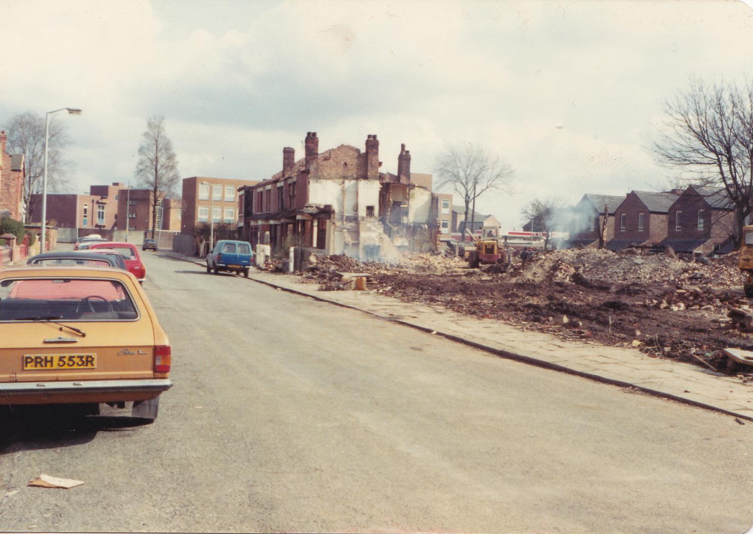
I must have walked down Ransfield Road loads of times in the late 70s and early 80s, but cannot remember these houses which were being demolished in Andrew’s photograph.

It was taken in the April of 1983 and like always there is a bit of story.

They date from the last decade of the 19th century and didn’t make their 100th birthday.  All of which is more puzzling given that they were six roomed properties and occupied by relatively well off working class people.  Here was a salesman a secretary, two clerks a plumber, tailor and a telegraphist.

And judging by Andrew's picture they were typical of what had been built at this end of Chorlton

Added to this the properties on the northern side of the road and those in the adjoining Claridge Road are still there. So there is a puzzle which a trawl of the clearance orders might throw up a reason or perhaps it was just a case of a developer buying the properties.

I had wandered down Ransfield Road just a few weeks earlier and couldn’t place when the new properties went up and for a while tracking the history of Ransfield was equally hazy.

Maps from 1907 showed them there but the street directories stubbornly refused to mention them.

All of which was because during the early part of 20th century Ransfield was called Richmond Road and may have been renamed because of the presence of another Richmond Road in Fallowfield, several Richmond Streets and two Richmond Groves one of which was here in Chorlton.

So in the process of exploring a line of demolished houses in the 1980s the quest turned up  another of our lost roads and in the process also points up that simple rule “never let an opportunity go by to record those moments of change."

Picture; from the collection of Andrew Robertson

Saturday, 31 January 2026

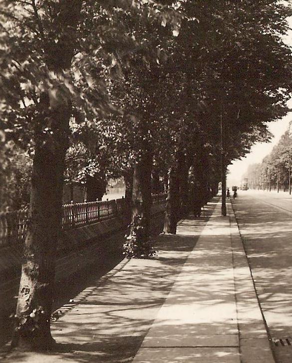
On a warm sunny afternoon on Barlow Moor Road, sometime before 1939


I like the way that old postcards can reveal our past in many different ways.

It’s every much as good as a detective story.

You start with the picture, move on to the postmark and the message and if you are very lucky may learn something from the manufacturer.

So here we are on Barlow Moor Road, sometime before May 1939, and judging from the trees perhaps on a sunny afternoon during the summer of the year before.  The trouble with these postcards is that the image may date back even earlier and will have been reissued over the years.

This one was taken by Harold Clarke of 83 Clarence Road Chorlton, and may have been part of a series issued by Lilywhite Ltd, of Brighouse, in Yorkshire.

There are 21 of his photographs in the Greater Manchester County Records collection dating from 1926 through to 1934 and some from 1926 carry a serial number close to the one in the picture.

Any way enough of the clever stuff and back to Barlow Moor Road on that sunny summer afternoon.  There is as ever a remarkable lack of traffic, with just a few cyclists a stationary hand cart, a couple of trams and what might be either a lorry or a coach away in the distance.

It looks to be afternoon judging from the shadows and the presence of the two school girls and it is scene which has pretty much vanished.

True the right hand side of the road looks familiar enough but the corresponding wall, railings and trees on the other side have long gone.

But having said that they were only demolished some thirty years ago when the road was widened and eventually the slip road onto the Parkway was constructed.

I will remember standing here waiting for a bus into town.  In the summer with the trees and the open land beyond that stone wall this was a pretty pleasant place to wait.

Nor am I alone in thinking so, because Lily writing on the back commented on how they had all enjoyed walking “under the shade of these trees.”

She lived on Withington Road and posted the card with its “Loving birthday greetings” on May 2nd, catching the 6.o’clock collection confident that it would arrive at 39 St Luke Street, Barrow in Furness for the following morning.

And it is still there today.

As is 83 Clarence Road, Chorlton where Harold A Clarke lived.

Although in the case of Clarence Road it is now Claridge which is the one that runs from Manchester Road over Oswald Road and into Peveril Crescent thereby offering up one last intriguing fact.

For here is another of our lost roads, or more accurately one of our renamed roads.

In 1911 there were three Clarence Roads.  There was our own as well as one in Longsight and another in Withington.

So not bad for one postcard.

Picture; from the Lloyd collection, date unknown

Saturday, 16 December 2023

Looking for Lloyd Street ........... the lost roads of Chorlton part 2


Now you won’t find it in Chorlton but it did exist and it was that short stretch of Whitelow Road running from the corner of Beech Road to that point where Whitelow bends to the left.*

This was once Lloyd land.  He was the second largest landowner in Chorlton buying into the township at the end of the 18th century and so I guess naming this little lane after him made sense.

Even now it is narrow  and hints that once it was just country lane with a few buildings on its eastern side and the large garden of William Cookson directly behind the Horse and Jockey.

But it is an interesting little place and reveals much about the life of our village.

Just at the end of the lane was the home of William Griffith.  The Griffith [s] family were active Methodists.

They appear in the ’41 and ’51 census in the tithe schedule rate books and Chapel registers.  William was a market gardener and one of his sons a wheelwright and his possession of freehold houses on Lloyd Street qualified him for a Parliamentary vote in 1832 1835 and 1840 which in turn marked him out as one of just 30 or so men who could vote.

For me an even more interesting man was Thomas Taylor.  He can also be found in the electoral registers for 1832, 1835, 1840 and 1854-55 by virtue of freehold houses for rent at end at the bottom of Beech Road and round into Lloyd Street.

These included what are now numbers 68-70 Beech Road and possibly whatever was on the site of the Beech Inn and extended on to the modern Whitelow Road.  Back in the 1840s nu 70 was the Travellers Rest which was a beer shop and nu 68 was a stationer’s and later the post office.

And it is his hand in the strange case of the loss of the Methodist Sunday school which had been in a building on the corner of Lloyd Street

This too had been built by subscriptions, and for a while was used by James Renshaw for his day school.

But the building was not secured by a trust and so reverted to the Lloyd Estate who sold the building to Thomas Taylor.

For a while Taylor charged the Methodists an annual rent but eventually in 1827 served notice on them to quit and the building was converted into cottages.

No detailed explanation has survived as to why the Methodists lost control of the building they had sacrificed so much to build but it was on Lloyd land and George Lloyd was devoted enough to the established church to give land for the building of the new National School on condition that “the school to be conducted upon principles consistent with the doctrines of the Established Church.” But it could equally have been a decision based purely on business.

Looking at the value of the cottages and the rents Thomas Taylor received it is easy to see that this might just have been a cash consideration, but more about this and the people who lived there another time.

Picture; Lloyd Street today, from the collection of Tony Walker, the Oven Door was the Travellers Rest back in the 1840 and what is now the Beech Inn may in part be all that is left of the cottages on Lloyd Street, map showing Lloyd Street from the OS map of Lancashire 1841-53, courtesy of Digital Archives,  http://www.digitalarchives.co.uk/

* It was still Lloyd Street in 1871

Friday, 15 December 2023

Snaps of Chorlton No 1 a lost road and a demolished house from Ida


Most of the images we see of Chorlton in the late 19th and early 20th centuries were the work of professional photographers. 

They arrived in the township, focused on the popular bits and sold them on to the postcard companies.  Sometimes on the off chance they prowled the new roads of New Chorlton and the Ville, taking pictures of individual houses and offering them at a knock down rate to the residents.

Then there were the serious amateurs like Aaron Booth* who in the early 1880s was taking photographs of Martledge. But there are also the snappers, who captured whatever took their fancy.  Often the images are a little blurred and in many cases have a significance lost in time.

And so with this in mind here is the new series.  Snaps of Chorlton, is an occasional rummage through pictures most of which were never meant to be shared beyond the family. Of course the advent of the camera phone has given this a new lease of life.

But for now I am concentrating on old fashioned images and I am starting with two from Ida.  The first was taken by her dad and while the date is unknown it must be before the development of the precinct, because this is Manchester Road from the corner of Wilbraham Road.  Back then it is still a tree lined road of big houses which gently curved round past the Savoy Picture House and around the library.  The car park has yet to break the sweep of the road.

It is a scene I featured recently from a 1938 postcard but is well worth another look.

The second is more recent.  We are on Beech Road, after the demolition of Row House and the factory which stood beside it.  And Ida’s picture perfectly reflects that other thing about snaps which is that they seldom are of popular or photogenic views which makes them equally important.

Row House dated from the early 19th century and had quite a history.  Here lived the Blomely’s who gave their name to the fish pond that ran from Acres Road up to Chequers Road, and also lived William Batty, politician, jeweller and Methodist  For a while the house was used as our “Penny Reading Room”, while the adjoining building had been a laundry and factory.

So its passing which generated a stir at the time is important as it was one of the last examples of an early 19th century property in the township.  And here I have a confession, for I have a brick from the house.  I asked for it and the demolition gang a little bemused handed it over.  It was handmade, perhaps with clay from our own clay pits off Oswald Road and I guess was put in place around about 1800.

And a little later Ida took her picture.

Location; Chorlton, Manchester

Pictures; from the collection of Ida Bradshaw


Tuesday, 27 June 2023

The lost road names of Chorlton


Now there are a lot of lost road names in Chorlton.  

I say lost but most are just name changes.

I guess it was matter of eliminating duplicate names which appeared elsewhere in the city.

So Regent became Reeves, Crescent became Crossland and Oak Bank changed to Silverwood Avenue.

Now the most obvious moment to make the change was when we elected to join the city in 1904, but the old names persisted beyond 1911 and may have stretched into the 1960s.

It is one of these little puzzles that really can only be solved by sitting down with the street directories and working through them year by year until the changes appear.  Or waiting for someone to remember when the new road name went up.

So if there is anyone who wants to come forward please do.

In the meantime just possibly there might be an easier answer in this photograph from May 1959 of Oak Bank Avenue, which is now Silverwood Avenue.

Oak Bank may well have its got its name from a large house also called Oak Bank directly opposite on Barlow Moor Road.

It was set back from the main road and hidden in an extensive garden and orchard surrounded by meadow and arable land. Once the home of William Morton, by 1847 it was owned by the wine merchant Frederick Cope, who lived there from 1850 to 1855.

The estate ran from the junction of Wilbraham Road and Barlow Moor Road south down to Oak Avenue, then back following the line of Zetland Road to Corkland and up to what is Wilbraham Road.   

It may be that the name was changed to avoid confusion with Oak Avenue, either way the date seems to have been later than 1959 unless of course A.H.Downes who took the picture in the April of that year just read old “late road sign.”

And here is the challenge for people to collect and send  their own road name changes.  I can think of a few more but I bet there are even more.

Picture; December April 1959, A.H.Downes m17489, courtesy of Manchester Libraries, Information and Archives, Manchester City Council, http://images.manchester.gov.uk/index.php?session=pass


Monday, 1 May 2017

The mystery of Cardiff Road in Chorlton

I wonder if there is any one left who lived in Cardiff Road in Chorlton.

In 1907
It was a small road of just eleven houses and I guess it owed its existence to our brick works which stretched along Longford Road.

The brick works opened at the beginning of the 20th century and Cardiff Road with its 11 houses  dates from just sometime between 1903 and 1907.

Four of the householders were connected with bricks. Two were brick makers and two brick layers.

In 2015
Today all that is left marking the road and its houses are these gates which Andy Robertson photographed this week.

Now I have never bothered to find out when they were demolished.

They were still there in the 1930s and probably went when the brick works were demolished which was sometime in the 1970s.

Already a decade earlier the works had been closed and attracted local lads drawn by the  opportunities to explore the derelict buildings and of course because they were a place of secrets.

In time I will track down the directories and work my through the pages from 1933 year by year until I discover when they were demolished.

Although the directories only go up to 1969 and I have a feeling the houses might have gone in the 70s, so we shall have to wait for someone to come forward.

And today a day after I reposted the story it has taken a turn with Stephen writing in to say that, "talking to a neighbour who lives opposite there and she says the photograph isn't where the road was. There's another curb a little further along where Cardiff Road actually started."

Location; Chorlton-cum-Hardy

Picture, entrance to Cardiff Road, 2015, from the collection of Andy Robertson, and detail of Cardiff and Longford Roads from the 1907 OS for Manchester

Wednesday, 11 January 2017

Looking for lost pictures of Chorlton and memories of Cardiff Road

Longford Road,, and that lost Cardiff Road, 2015
Now as pictures go it is not the most promising of images, but it offers a story.

That said if you want to know about the lost road which once stood beyond the gates you will have to follow the link.*

Instead I want  to ask for photographs of Longford Road including the field currently owned by the MMU.

And before any resident worries that this is part of a development bid rest assured it is just the start I hope of a series of stories about this end of Chorlton, and in particular the brick works which has featured on the blog and which still stirs the memory of those now in their 60s. who once played amongst the old kiln and ran at the first sight of  "Duffy."

Picture, entrance to Cardiff Road, 2015, from the collection of Andy Robertson

*Chorlton's industrial history, http://chorltonhistory.blogspot.co.uk/search/label/Chorlton%27s%20industrial%20history