Showing posts with label Chorlton Houses. Show all posts

Monday, 2 November 2026

That unusual picture of the old parish church ….. with a heap more

 This is one of my favourite pictures.


It has appeared countless times before on the blog, and I never tire of writing about it.

This is the old St Clement’s church which stood in in the parish graveyard on the edge of the village green.

I can’t be sure when the photograph was taken, but it was a Reaud picture postcard and was sent to a Miss Clay of Brooks Bar in the September of 1904.

By then the parish church which had served the township since 1800 had just another 37 years, before it was closed because of frost damage, and its congregation joined those of the new church on Edge Lane.


This tall brick church had replaced an earlier timber building which dated back to the early 16th century, and had originally been the Chapel of Rest for the Barlow family.

It is an unusual image and despite its “colorization” has a lot to offer.  Even after a good ten years of researching its history I have to say it is an ugly building, made more so by the two extensions added in the 1830s.

To our left is an old cottage which dates from the early 19th century and may already have been there when King George lost the American colonies.

In 1841 it was home to John and Mary Taylor. 

In the June of that year he had described himself as an agricultural labourer and a decade later aged 72 he was still working on the land while his wife took in laundry.


Now it is impossible to say which farm he worked for or whether he was part of the casual workforce which found work where they could, but there were three farms around the green and another along what is now Brookburn Road

They rented the house from John Renshaw who had owned properties around Chorlton and paid him 1/6d a week in rent. Now this was about the going rate for such a cottage although rents began at just over a shilling [5p].

The cottage stood on open land with fine views back across the green and out toward the Mersey. Like most homes of the day there was a small cottage garden.

Now using the tithe map it is possible to locate the spot the picture was taken and this was Lough Orchard Meadow which in 1845 was one of the fields James Higginbotham rented from the Egerton estate.


Like the surrounding fields it was meadowland which was set aside for growing early grass.  

Mr. Higginbotham rented land across the township, and lived in the farmhouse facing the church school across the village green.  His house is still there, although the barn beside it has been converted in to residential use.

I will leave it up to you to suggest exactly where that field is today.

Leaving me just to comment on the buildings to the east of the church which included another barn, while  lost behind the trees is the Old Bowling Green Inn, which dated back to the late 17th century and was torn down in 1908 to build the present pub.

And for those who like detail there are the arms of what will be a cart, sticking up into the air.

Pictures; St Clement’s Church, circa 1900, and Mr. Taylor's cottage, circa 1900, from the Lloyd collection 


Saturday, 12 September 2026

Looking out from Cross Lane ....... across the fields of Chorlton-cum-Hardy with Mr Samuel Walton

In the spring of 1877, Mr Samuel Walton would have had a fine view from his house on Cross Road out on to the fields which stretched down Beech Road.

Cross Road, 2018
He had moved in earlier that year and was the first occupant of the house built by a John Rhodes.

During that first year the annual rent for the property was £25 per year, which rose later in the next decade by three pounds.

By then Mr Walton had bought the house and moved out renting it to a succession of tenants.

I had always assumed that the houses on Cross Road dated from the early 1870s, but on being asked to do some research on one of them I discovered that they had been built in two phases.

The lower numbers were there by 1871 but the rest came along a little later.

They were some of the first new “posh” build in what was still a rural area.

Row Acre directly beside Cross Road, 1894
To the east of the long gardens of the houses on Cross Road was the large walled garden of Beech House which belonged to the Holt family along with a set of cottages which jutted out onto what we now called Beech Road.

The name Beech Road is relatively recent, before that and no doubt running back centuries it was called Chorlton Row, and by the 1840s, consisted of a few wattle and daub houses dating into the 18th century, two fine houses built in the early 1800s, a couple of farmhouses, a beer shop, the Wesleyan Chapel and the village smithy.

The Rate Books also show that Cross Road underwent a number of name changes, beginning with Cross Lane, then Cross Street and finally Cross Road.

Looking out from Cross Road, 1894, on all that was left of Row Acre
And for all those who never tire of telling the assembled crowd that Chorlton has no streets but only roads, this might seem a revelation, and one that I shall follow up with the fact that Acres Road was once Acres Street and the small stretch of road from the Chorlton Green past the Beech Inn to where there is a twist in the direction of the road was Lloyd Street.

And so back to Mr Walton and that house whose views out on Row Acre were changing.

By the late 19th century Row Acre was getting nibbled away till all that was left was a 2 acre patch bounded by Beech Road, High Lane, Cross Road and Wilton Road.

It was last ploughed in 1895 and was gifted to the people of Chorlton-cum-Hardy by the Egerton’s as a Recreational Ground.

And that is it.

Location; Chorlton-cum-Hardy

Pictures; Cross Road, 2018, from the collection of Andrew Simpson, ploughing Row Acre, courtesy of Mr Higginbotham from the Lloyd Collection, and Row Acre, 1894 from the OS map of South Lancashire, courtesy of Digital Archives Association, http://digitalarchives.co.uk/

Sources; Census Return , Chorlton-cum-Hardy, 1871-91, Rate Books, 1877-1900

Friday, 4 September 2026

That mystery house on Beech Road ........

Now number 121 Beech Road vanished a long time ago.

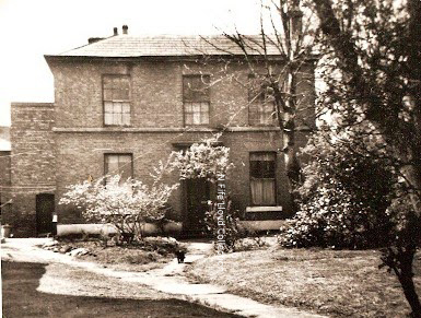
Hunts Croft, circa, 1960s
It was one of our more elegant early 19th century properties which was set back from Beech Road, and went sometime in the 1970s.

For a long time after its demolition the land was left an open space, with the occasional suggestion that it could be a car park, a project which came to nought when the Corporation and the local traders couldn’t agree on a funding package.

There will be a few people who remember it, but sadly I am not one of them, which means it had gone before I arrived in 1976 or like so many things I was just not that observant back then.

Either way, there is little to mark its presence, save an entry in the tithe schedule for 1845, the Rate books and official maps.

If I have this right, it was Hunt Croft House and in 1845 was the residence of Thomas White who rented it from the Lloyd Estate.

With a lot of digging it will be possible to track its history through the 19th century till its demolition. I know that in 1969 it was occupied by a Frances. J Casse, and in 1911 by Mr and Mrs Chester, their five children, and a boarder.

Looking into the garden, circa 1970s
The house had nine rooms with a biggish garden at the front, ending in a tallish stone wall which ran along Beech Road.

Back in the mid 19th century it looked at on fields.  From the rear Mr White could look out on a field and orchard, while from his front windows he could gaze across to Row Acre, which stretched up to High Lane.

But by the 20th century the fields had all gone, and on either side of this fine old house were shops.

Beech Road, circa 1970s
And here I must admit my mistake, because for years I had mistaken Croft House for Joel View which stood a little further down the road and had been built in 1859.

Many will remember Joel View as the property owned by J Johnny, which I assumed had been built much later.

I even compounded the mistake by arguing that the stone tablet which carried the  name of Joel View had been salvaged from Mr White’s former home and been added to J. Johnny’s.

Dating the picture
Now, even then I knew that this was pushing it, because our own historian Thomas Ellwood had written that Joel View was one of the new developments in the township at the end of the 1850s.

All of which goes to show that sometimes when it is easy to ignore the obvious and create an elaborate theory which is built on sand and that is really just a lead in to two pictures of Hunt’s Croft sent to me by Roger Shelley who took them sometime in the 1970s and which had lain in his negative box until yesterday.

The two images compliment an earlier one taken by N. Fife for which I don’t have a date for, but maybe from the 1960s.

That said it might be possible to date Roger’s pictures, from the shop which is up for sale.  This had been Mr Westwell’s fruit and greengrocer shop in 1969, but sometime in the next decade became The Village Wholefood Shop.

Hunt's Croft demolished, circa 1979-early 1980s
It was still trading when I took a picture around 1979, showing the shop and the site which had once been Hunts Croft.

So that is it for now, although I am hoping Roger has more pictures.

Location; Chorlton


Pictures; Hunts Croft circa 1960s, courtesy of N Fife, the Lloyd Collection and again circa 1970s from the collection of Roger Shelley, and after it had been demolished circa 1979, from the collection of Andrew Simpson

Saturday, 25 July 2026

Who stole Alton Towers?

Today I was reminded by my old Facebook chum Bill Summers of that house on Edge Lane called Alton Towers.

Alton Towers, 1907
Like him I have often come across it on maps and set to the challenge he laid down today, when he posted the 1911 OS map showing the property adding, “We all know roughly where Alton Towers is or have heard of its pleasure grounds but might be surprised to discover there was another- in Chorlton cum Hardy back in the day. 

Just wondering if Andrew Simpson can tell us anything of it. 

It stood for a while at the side of St Clements Church on High Lane, so maybe there is a photo out there somewhere". 

It was a challenge I couldn’t turn down.

Today the site is open land and was gifted to St Clement's for the use of young people and is now part of the school, and that is pretty much how I remember it from when I washed up in Chorlton in 1976.

The site of Alton Towers, 1933
The last recorded reference to the house is on the 1911 census  but interestingly it is not listed in the street directory for that year and the OS map for 1933 shows it as open land with a tennis court in one corner.

So sometime between 1911 and 1933 it disappears.

I can track it back from 1911 to 1879, and I am fairly sure that 1879 marks the date when it was built.  

It was owned throughout by John Richardson who rented it out to just five tenants over those thirty years.

It had been a grand house with ten rooms, set back from the main road in a large garden and commanded an annual rent of £100 and a rateable value of £68.

And not to be short changed had a series of green houses arranged amongst the trees in the garden.

In 1911 it was occupied by an Edward and Christina Wright, their four children and two servants.  Mr. Wright described himself as a “Paper merchant" with his offices at 62A Fountain Street. 

The site in 2023
What happened after 1911 is yet to be discovered but I do know that one of his son’s was living at 22 Whitelow Road in 1917, because his Attestation papers say so.

It may be that the family moved from Edge Lane to Whitelow Road.

There is no reference to Alton Towers in the 1921 census, and sadly so far the only images we have are of a gate post on pictures dated in 1930 and 1959.

Sad looking gate post, Alton Towers, Edge Lane, 1930
Not that I am finished.

I shall explore the life of John Richardson, and talk to St Clement's Church about their acquisition of the land and follow up the story of a fire.

so heaps to find out.

We shall see.

Location; Edge Lane

Picture, Alton Towers, 1909, OS map for Manchester and Salford, 1909, site of Alton Towers, 2023, courtesy of Google Maps and Only a sad looking gate post, Alton Towers, Edge Lane, 1930, m17809, courtesy of Manchester Libraries, Information and Archives, Manchester City Council, http://images.manchester.gov.uk/index.php?session=pass


Sunday, 19 July 2026

Tracking the age of your house in Chorlton

Now one of the first golden rules of research is that you never turn down any information you are given.

It might not fit with what you are doing but from experience it will sometime in the future.
Age of Buildings of chosen area

All of which is why I leapt at the offer from Phil Portus of an undergraduate project he undertook on Chorlton in the summer of 1968.*

Phil was in his first year of a Geography and Geology BSc and set out to answer the question “to what extent did Urban growth after 1850 proceed within the physical framework of pre-existing patterns of land ownership” which involved using the tithe map of 1844 and comparing it with OS maps of the period from the 1840s across the rest of that century and into the next.

The final piece of work included his written answer along with a series of beautifully drawn maps and overlays showing land ownership in 1844, the age of buildings from before 1844 through to 1955 and two detailed overlays of land ownership and the age of properties on the northern side of Beech Road from St Clements to Barlow Moor Road and back to Hardy Lane.

What is all the more remarkable is that this of course was done before the internet which meant that there was no recourse to online searches and pretty much everything was drawn from documents held in the archives and local history library down at the Ref.

And judging by his conclusions also involved a lot of field work out on Beech Road and the neighbouring roads observing the properties and matching their position against the field boundaries and the tithe plan.

All of which contributes to our knowledge of the history of Chorlton.

Detail from Age of buildings in chosen area
But like all research it also offers up unexpected information and prompts for further research.

So while I knew that the social housing which stretches south down Barlow Moor Road dated from before the Second World War I had never researched it in enough detail to come up with an end date of 1923.

Likewise Phil confirmed what I always suspected that small pockets of infill development around Ivy Green were undertaken between 1939 and 55.

Which just then left those unintended consequences, like the date that Church Road became Chequers.

Now I am not alone in spotting just how many name changes were made, and plenty of people have their own personal one, but I had always been puzzled as to when this might have happened.

The logical date was when we voted to join the city in 1904 but the changes were much later with people suggesting the late 1960s or early 70s and Phil at least has confirmed that Church Road was still in use in 1968.
That said Stephen has commented, "I can't agree with the idea that Chequers Road only got that name as late as 1968. I was at St John's RC primary school from 1955 to 1962, and it was Chequers Road then. 

Maybe some locals still referred to the old name. I still think of Zetland Road as Holland Road, it's old name, as the name change took place after I had ceased to use it on a daily basis to get to and from school."

So there you have it, a piece of research undertaken forty-nine years ago which  is still doing the business but may need a revisit.

*Salford Project, http://www.philportus.co.uk/salford-project/

Picture; overlay of properties on the north side of Beech Road, 1968 courtesy of Phil Portus

Saturday, 18 July 2026

The humble outside lavatory ….. here in Chorlton ….. wondering how many have survived

Now for anyone who grew up or lived in a 2 up two down property, this brick structure will be familiar.

Declan's brick structure, 2021

And for those who  wonder what I mean by a two up two down property, they were the basic model for many working class homes in the 19th century, and consisted of two downstairs rooms, one of which would be the kitchen with two upstairs rooms.

You can still find them across the country in our towns, cities,  and villages and with a bit of tender care and attention still do the business.

You entered directly off the street into the front room, although at the posher end of the market, there would be a small glass vestibule which took up a little of the space in the front room but did afford a bit of privacy.

New Gates, typical Manchester Court, 1908

At the rear was a small yard complete with an outside lavatory, which before mains sewage were supplied with a pail which would be collected by the night soil man.

Ours in Ashton Under Lyne still retained an aperture in the back wall where the pail could be left for collection.

And that is where Declan Maguire comes into the story, because yesterday he sent over this picture, adding, “Hi Andrew, after your article on the few air raid shelters still surviving in back yards, here’s a photo of another backyard survivor from Victorian times. 

I wonder how many houses in this area still have one of these? 

I can think of times when I was sharing my home with teenager ‘bathroom blockers’ when it could have been useful for me.

I wonder how would they be referred to in estate agent pitches; “many original Victorian features”? “bathroom and second separate toilet?

It would  be interesting to find out if many have survived locally, whether in working order, or as tool/storage sheds. 

I’m old enough, (born in 1960 in Belfast, another red brick Victorian city), to have used these during family visits to grandparents and other relatives. I can remember the new WC being installed inside my maternal grandparent’s 3 storey terraced home around 1970. The photo was taken in one of the side streets off Sandy Lane, the house is currently up for sale & unoccupied”.

Whiteman's Yard Derby, 1882-83

And being a tad older, I remember visiting my grandparent home in Derby which was a conversion from two one up and one down properties into a single home.  The rear of the house had opened up to a small shared courtyard where there were several of these little brick privies.

Manchester Corporation had been in the forefront of eliminating the one up one down as early as the 1850s, along with cellar dwellings.  Other cities like Leeds tolerated the one up and one down into the 20th century.

As for our humble brick lavatory it would be the coming of mains water that would banish the weekly visit of the night soil man.

That said in 1894 in Manchester,  “there were 24,300 water closets,  78,486 pail closets, and 35, 700 midden privies, and even by 1927 there were 230,046 water closets, and still 1,108 pail closets and thirty-five privies”.*

All of which beings us back to Declan’s brick “outhouse”, and Chorlton-cum-Hardy.  By the time his old house and most of two up two down stock were built in Chorlton in the late 19th century, the township had mains sewage.

But this was a new thing.  The first pipe bringing in mains water arrived in 1962 at the request of 16 ratepayers living on Edge Lane, while the local sewage works was only developed in the 1870s.  Before then people used privies, and obtained their drinking water from wells, or surface water.  

So when Stockton Range was built on Edge Lane, they were built with interior wells.


But the great housing boom which started in the early 1860s, and the much bigger provision of houses from the 1880s was only possible because of the arrival of piped drinking water and an effective sewage system.

Some historians have pointed to the arrival of the railway in 1880 and the corporation tram two decades later, but without the basics of water and sewage it is difficult to see how that housing boom could have taken off.

Pictures; A little brick outhouse, 2021, from the collection of Declan Maguire, Whiteman's Yard, detail of the OS Map of Derby 1882-83, supplied by Derby Local Studies Library http://www.derbyshire.gov.uk/leisure/local_studies/  and New Gates, 1908, m8316,  courtesy of Manchester Libraries, Information and Archives, Manchester City Council, http://images.manchester.gov.uk/index.php?session=pass

*E. M. Brockbank, The Book of Manchester & Salford, 1929, quoted by John J Parkinson- Bailey, Manchester An Archetctural History, 2000, page 40


Friday, 17 July 2026

Five pictures …… one road …… and a heap of Chorlton’s story

This is Brook Lane in 1909 on the cusp of a change.

1909

For centuries it had led out of the village past the old Bowling Green Hotel, crossed Chorlton Brook, past Brook Farm, and petered out in several footpaths, one of  which twisted off towards Hardy Lane.

But in the spring of 1909 the eastern side of the lane was being developed by a row of new houses, which faced the entrance to the sewage works, and the home of Charles Hall the manager of the works.

In the distance there is still open land which within a year and bit will be filled with the new Chorltonville estate, while the new brick sides of the bridge over the brook have yet to replace the low stone wall and to the right the scene is dominated by the farm buildings of Charles Cookson who lived in Brook Farm.

1911

The new row of houses bears closer inspection, because the first is being constructed to accommodate a shop, and later photographs show that it was occupied by Mrs. Harrier Forster whose window announced that it was a confectioners, and given that it was the only shop in the row of ten properties I guess she sold a few other “essential” items.

And at the beginning of 1910, Mrs. Forster’s neighbours included a joiner, two engineers, a waiter, and a designer along with two clerks and an architect. 

In time I will trawl the census returns to find out more about these residents and the lives of Charles Cookson and Charles Ball.

1910

For now I will just add the remaining three images , one looking back towards the new Bowling Green Hotel showing the club house, and two looking up the lane.

What makes these two interesting is that they qualify as then and now pictures.  

The first, as the shop is still yet to be finished, and before the ville was built, and the other with Mrs. Foster in residence and the new estate in place.

Together they offer up a series of images of where we live as the township continued on its journey from a small rural community to a large urban settlement on the edge of Manchester.

1910
Just six years before our first picture, Chorlton  rate payers had voted to join the city along with Burnage, Didsbury, and Withington, while at the turn of the century Manchester City Corporation trams had arrived, predated by arrival of the railway.

And the second major housing boom which began in 1880 had transformed the nort side of the township, eliminating the historic hamlet of Marledge and in the minds of many, dividing Chorlton into Old and New Chorlton and creating the two villages of Old and New Chorlton.

Location; Brook Lane

1912


Pictures; of Brook Lane, 1909, J. Jackson, m17679, 1911, B.F., m17684, J. Jackson, 1910, m17681, J. Jackson 1910, m17680, J. Jackson, 1912, m17685, courtesy of Manchester Libraries, Information and Archives, Manchester City Council, http://images.manchester.gov.uk/index.php?session=pass


Monday, 13 July 2026

One old picture ….. a mystery location ….. and the Chorlton debate

Now I have Lee Hutchings to thank for this image.


He posted it today on a Chorlton Facebook site and it invites intriguing questions of just where we are, and the identity of the three individuals.

I doubt we will ever know their names but with a location we might be able to check on the occupants of the house and make a guess using the historical records.

Which of course just leaves the hunt for that location.  We are looking out on a well-established front garden with a lane and fields beyond, with just a suggestion of open water in the distance and a date of 1898.  There is furthermore a reflection of another house in the windows of the front door, which must have been opposite ours.

The lamp would perhaps indicate that the lane was well used or important enough to have public lighting at a time when this was not common in Chorlton.  

The first four street gas lights date from 1875 and a trawl of the records of the Withington Local Health Board and its successor the Withington Urban District Council might reveal the onward march of lighting provision and in turn reveal possible locations which match our picture and the date.

And I rather think our house might be one of a pair, which could narrow the hunt slightly.

So, with an address we could hit lucky and find occupants who resemble the people in the photograph.

The three look as if they are posing with that uncomfortable attempt to “look natural” which is rather negated by the artificial pose of the dog on the chap’s shoulder.

Already and rightly so there has been some speculation on where we are. The consensus so far is Beech Road with the Rec directly opposite.

It is plausible.  The Recreation Ground was opened in 1896, and our picture is dated two years later, but I think not.

This stretch of Beech Road facing what is now Beech Road Park down to Ivy Farm was undeveloped and remained so until Joe Scott built the row of terraced houses in 1915.

Wilton Road could be an alternative but there were no houses matching that reflected building nearby.

All of which leaves Cross Road, its houses are all in situ by the late 1880s and just maybe that reflected building has a mirror in the tall mid 1870s buildings on the corner of Cross Road and Beech Road.

But I am unconvinced, leaving me to think we still have a mystery.

And of mysteries I am fascinated by the thumb print on the picture. It is fruitless to wonder how we could identify it but it is one of those exciting but intangible bits of history which march alongside speculation on the identity of the last person to handle the grave goods of Tutankhamun or the strand of hair placed in a locket beside the ancient burial of a young bride.

But enough of such romantic tosh ….. bring on the debate on the location of our house.

But answers will only be judged worthy of consideration if like John Anthony Hewitt you make out a compelling case.


It maybe just be that we should be looking elsewhere and that open land in the distance is not the Rec but open fields yet to be built on.

We shall see.

Location; as yet unknown

Picture; the mystery house the unidentified people and a street gas lamp, courtesy of Lee Hutchings, 1896, restored and colourised 2026

Friday, 29 May 2026

Looking out from Barlow Moor Road in the summer of 1960

There is a singular lack of images of Chorlton during the middle decades of the last century.


Look through the collections and you can find plenty of fine examples of what the township looked like during late 1800s and early 1900s.


Most are from commercial photographers who sold their work on to picture postcard companies, and never missing an opportunity also took plenty of photographs of individual streets, which they then offered up to residents for “a knockdown price”.

But by the 1950s the golden age of picture postcards was drawing to a close, just as cameras became cheaper and more readily available, which ushered in “the snap”.

The snap was usually a very personal image, sometimes a little out of focus and in most cases consigned to a photo album, or the back of a cupboard.


Sometimes the odd one gained pride of place on a fridge or notice board, only to fade with the years and become “tired” from much passing around.

All of which brings me to a set of sketches made by my friend Ann of the Chorlton she knew back in the 1960s.

Ann grew up on Barlow Moor Road at what is now 523 , and as part of various art projects she sketched some of the rooms in the house as well as view out across the back garden.

And include three of Chestnut Avenue, which were made in the summer of 1960 and included “The first house on the right which was an Opticians, when I lived at 523”.

Location; Chorlton

Pictures; Chestnut Avenue, August 1960, from the collection of Ann Love


Sunday, 17 May 2026

The photograph, a house on South Meade, and a mystery

I am looking at a picture of a group or workmen outside a house on South Meade and at first glance there doesn’t seem to be anything unusual about what I am looking at.

The men represent a cross section of skills, ages and experience, and may well have posed for similar photographs across Chorltonville.

But I know exactly which house this was and have already begun to discover its history which starts with the simple fact that it has been occupied by only two families in the century and a bit since it was built.

And so, while we will never know the identity of the men staring back at us, we do have the deeds, as well as a collection of documents relating to its construction, which will help tell the story of this particular house.

The first family to move in was Mr. and Mrs. Jones.  In 1939 he described himself as a “Commercial Traveller in the Gas Industry”.

Everyone will find something interesting in the picture, with some focusing on the appearance of the men, the presence of the apprentice boy, and the flat caps and pipes.

The building contractor was Thomas Whiteley and a search might turn up something about the building firm, but I doubt that will extend to a list of employees.

For now, until Laura passes over its history for me to look over, we are left with the photograph of the workmen and the image of the house.

But for now, it is exciting that we are able to pin a group of craftsmen to one house sometime in 1911.

Leaving me just to ponder on Mr. and Mrs. Jones and a mystery which might be answered by those documents.

We shall see.

Location; Chorltonville

Picture; workmen outside South Meade, 1911, courtesy of Laura Hopkins

Special thanks to Laura, who kindly showed me the picture and has promised to lend me the house documents and to Jude who lives next door, and first told me about the picture.

Saturday, 9 May 2026

When the bulldozer came to Beech Road ………… well almost

I just missed the battle which if lost would have seen a swathe of properties from Crossland Road north across Beech Road and encompassing Acres Road demolished because they were judged “unfit for human habitation”.

Summer Cottages, 1958
I knew that there had been plans, and at one stage a small row of cottages off Beech Road were demolished in the early 1970s.

These were Summer Cottages, and were probably the last one up one down cottages and occupied part of what is now The Forge.*

And I always thought that Summer Cottages were the properties that Richard and Muriel often referred to as part of a clearance scheme. 

Richard and Muriel ran the greengrocers on Beech Road and Richard in particular was still quite cross about the plan a decade later.

The City Council had already demolished some cottages at the top of Sandy Lane in the 1950s or 60s and went on to clear Brownhills Cottages also on Sandy Lane and another row on High Lane.

Crossland Road, 1972
But I was unaware of the extent of the planned clearance around Beech Road.

It would have included the demolition of some of the houses on Crossland, Road, all of Redbridge and Stanely Grove, some of the shops on Beech Road  as well as Acres Road and possibly a section of Whitelow and even Chequers Road.

The Guardian in the March of 1974 reported on a City Council scheme to demolish 750 properties in the Slade Lane, Chorlton, and Didsbury areas.

Here the residents of the proposed area reacted with a mix of dismay, anger that there homes should be labelled “slum dwellings” and resolved to organise to oppose the plans.

Stanley Grove, 1972
A resident’s association was formed which linked up with similar groups across the city and worked with experts from Manchester University, Town and Country Planning specialists and commercial companies along with “The People of Chorlton”.

Their report dated March 1974 arrived in our house yesterday and it makes for fascinating reading.  

It consists of three parts, which are the Residents’ Case, the Social and Planning Context, and Technical Report.  The third part is supported with costings, suggested alterations to named properties, and a time scale.***

By October the City Council had revised its plans and chose to renovate the properties, a wise decision which has left us with so many fine 19th century houses and retained something of the character of old Chorlton.

Redbridge Grove, 1972
There is much still to so.  I would like to clearly define the area which would have been redeveloped, and solicit the memories of those who took part or just remember the campaign.

Some of those are listed in the report.

Added to this there will be the minutes of the various City Council committees and the story as reported by the local newspapers.

So much still to do.

Location; Chorlton

Pictures; Summer Cottages, R E Stanley November 1958 m17666,  Crossland Road, H Milligan, m18209, m18209, and m17732,  Stanley Grove, 1972, A Dawson m18210 courtesy of Manchester Libraries, Information and Archives, Manchester City Council, http://images.manchester.gov.uk/index.php?session=pass Acres Road, 2023, courtesy of Google Maps

Acres Road, 2023
*Summer Cottages, the hidden homes behind Beech Road, https://chorltonhistory.blogspot.com/2012/04/summer-cottages-hidden-homes-behind.html

**Taken for Granted? Gillian Linscott, Guardian March 23, 1974

***Chorlton Village, the residents association’s case for improvement March 1974

****Council’s about turn on Housing, Michael Morris, Guardian October 3rd, 1973

Friday, 8 May 2026

Mr. Taylor’s very old cottage ……….. on the edge of the meadows

Now I am back with a familiar picture which has appeared before on the blog.

Mr. Taylor's cottage, date unknown

The caption just says, “old cottage near the meadows, Chorlton-cum-Hardy”, and to add to the lack of detail the image is undated.  

I might be able to track down when the image was first used by the Reaud picture postcard company, because we do have a catalogue number.

Trying to locate exactly where it was continues to be a challenge, but I think we are on what is now Brookburn Road, with the Bowling Green Hotel roughly behind us on what is now a new build, but was once the United Servicemen’s Club.*

The footprint of the cottage conforms to a property shown on the OS map for 1894, and is similar to ones which show up on earlier maps from 1854, back to 1818.

The cottage opposite the Bowling Green Inn

During the 1840s, it was home to a John Taylor who had been born in Chorlton in 1784, and gave his occupation as an agricultural labourer.  

The cottage was owned by the executors of John Renshaw who had an extensive property portfolio across the township, including Renshaw’s Buildings which were on the site now occupied by the Royal Oak Hotel.

By 1851 Mr. Taylor was still in a Renshaw property but had moved to a house in Martledge.

Judging by the census return from that year he was still working, although does appear to being sharing the home with a Mary Taylor who was six years younger and described herself as a “laundress”.

In time it will be possible to track some of the other residents, and determine when the house was demolished which I think may be the mid 1920s.

I have always been fascinated by this picture, particularly because it offers up an image of cottages which had once been typical of the properties in the township and may date back to the late 18th century.**

It looks to be larger than some labourer’s homes, which were one up one down, and it has space for a cottage garden.

Location; Chorlton

Picture; “old cottage near the meadows, Chorlton-cum-Hardy”, undated, from the Lloyd Collection, and its location from the Tithe map of Chorlton-cum-Hardy, 1845

* That club on Brookburn Road in Chorlton ....... and a fascinating find  https://chorltonhistory.blogspot.com/2020/08/that-club-on-brookburn-road-in-chorlton.html

**A property roughly in the right place shows up on Yate’s map of 1786.


Friday, 2 January 2026

“the green fields of one summer are the roads and avenues of the next.”


This picture of Oswald Road perfectly sums up what we had become by the early decades of the 20th century.  

For most of the early and mid 19th century we had been a small rural community growing food for the markets of Manchester.

But with the coming of mains water, a gas supply and later a railway station we were quickly transformed in to a suburb of the city.

It was as the Manchester Evening News commented in the September of 1901 so swift a development that “the green fields of one summer are the roads and avenues of the next.”

And something of just how quickly the roads and avenues appeared can be got from the street directories for the early 20th century.  These were not unlike our telephone directories in that they listed the householder in each road, street and avenue, with the added bonus that they often give the occupation.

And as I write I am looking at the directories for the three years of 1901, 09 and 11 and have chosen that collection of roads around Oswald Road.  Here is a remarkable story of piecemeal building as speculative builders vied with each other to build anything from a single house, to a semi up to a terrace. 

The development is patchy and is partly conditioned by changing land use.  So on the corner of Oswald and Longford Roads, what was once open ground, became a skating rink and later a row of eight semi detached houses built I guess sometime after 1916 and more likely in the years after the Great War.

In some ways these first inhabitants must have felt a little like pioneers, with views across the fields towards Turn Moss uninterrupted by other houses. Well, until the brick works arrived but that is another story.

The fun thing to do is to go and look for yourself.  Armed with copies of the1893 and 1907 OS maps and with just a little knowledge of building styles it is possible to distinguish the large Victorian piles from the Edwardian semis and terraces and the speculative in fill of later decades.

But it occurs to me that in all the stories of the new rows of houses, and the reasons for the rapid development of Chorlton at no time have I presented that population increase and so here it is.


Pictures; Oswald Road from the Lloyd collection, detail of 1907 OS map and the changes in population from 1841-1911.

Wednesday, 24 December 2025

Looking for stories ………. from one house in Chorlton

Now, it has become popular to take a pretty ordinary house and trace its story back in time.

The house, 1959

I have to confess it is something I have done with three of the houses I have lived in over the last seventy years, and more recently the idea has become a successful television series.*

All of which is an introduction to Bamburh House on High Lane.

It featured yesterday on the blog when I began to explore its history.

And I have returned today with part two.  It was to be the story of some of the domestic servants who toiled away in the background rarely recognized, but essential to the well being of the family who employed them.

The idea was partly prompted by my own interest in those “who toiled”, and also from a comment by Sarah, the present owner that “When we bought the house we opened up the attics and there was a bedroom for a maid up there. 

I will dig out the pictures just for your interest because although the staircase carried up to her room she would’ve had to bend  double to get under the roof to enter”.

But as so often happens their stories are harder to piece together, and despite an afternoon wandering the records the four I chose led almost nowhere.

I had started in 1871 when the house was built, with a Miss Taylor aged 23, and young Agnes who was just 14 and employed as a “nurse”, but the enumerator’s handwriting was almost undecipherable, and my best shots led nowhere.

And while a decade later I could at least identify a Sarah A Edwards and John Strawbridge, they too remain in the shadows.

High Lane, 1881, the house marked with an X

Still there are plenty more to look for, and in time I will go looking.

All of which leaves me falling back on the house and exploring a little bit more of its past, which begins with an interesting mystery concerning John Strawbridge who in 1881 is described as a groom, suggesting the then owners had a horse and carriage.  Maps of the period show outbuildings behind the house on the west side, but later census returns make no reference to a groom.

The last census records that in 1911 Mr. Robert Newberry West, who was a surgeon, employed Elizabeth Parker as “cook-domestic” who was charged with maintaining the elven rooms and cooking for Mr. West, his mother and his two siblings.

The house, 1881, marked with an X

I have to say I have been drawn to Robert West, partly because he was born  in Camberwell,  close to where I was born and grew up in south east London and because we can track his progress from London to Chorlton-on Medlock where his father was the vicar at St Stephens and on to Southport where he lived with his widowed mother.  

He married in 1920 at the grand old age of 47, living on Upper Chorlton Road and finally Barlow Moor Road where he died in 1924.


Nor is that quite the end of the story, because like many bigger properties in south Manchester,  Bamburh House finally succumbed to multi occupancy.

Just when this happened is unclear.  

In 1929 the directories show that it was occupied by the Morris family, but a decade later the house was divided in to five flats of which two were unoccupied.  The remaining three were occupied by a sales manager and sales assistant, neither of whom were married, and Mr. and Mrs. Bond and their young daughter. Mr. John Bond was a sales manager for a tobacco and drugs company, his wife Doris was “an assistant hospital nurse” and Rita, their daughter was just 2 years old.

After which the house continued its long association with multi occupancy.  In 1954 it was home to three tenants, and in 1962 to four, and it remained so until Sarah bought the property and returned it to family use, which of course has been a trend across Chorlton.

With thanks to Sarah for allowing me to profile her house and Tony Petrie who supplied the street directories for 1929, 1959, and 1962.

Location; Chorlton-cum-Hardy

The house, 1956

Pictures; the house in 1959, A. E. Landers, m17886, courtesy of Manchester Libraries, Information and Archives, Manchester City Council, http://images.manchester.gov.uk/index.php?session=pass High Lane in 1881, from the 1881 Withinton Board of Health map, courtesy Trafford Local Studies Centre, https://www.artuk.org/visit/venues/trafford-local-studies-centre-6551 and in 1956 from the OS map of Manchester & Salford, 1956

*The story of a house, 

One hundred years of one house in Well Hall 

The story of one house in Lausanne Road, 

The house on Harrow Road in Leicester,