Showing posts with label Manchester in the 1960s. Show all posts

Friday, 31 July 2026

Cleaning the Town Hall …….. 1967

Now for anyone who doesn’t remember the Town Hall when it still had nearly a century of Manchester soot and grime, here is the picture.

It was taken in 1967, just three years after the City Council had estimated the cleanup would cost £25,000.

And what I like about the image is the contrast between the dark stone, and the two sections which have been cleaned.

As dramatic as the clock tower looks, I rather think it is the section on Lloyd Street which offers up just what the cleaning had achieved., highlighting the detail in the stonework and lifting the section to the eye.

Why they began with Lloyd Street will be on record somewhere, but I suspect it was the trial, which if it went wrong was down a side street.


Nor is that all that the picture has to offer.

Albert Square was still an island surrounded by traffic, with provision for parking opposite the Town Hall, and the underground Victorian lavatories, with their period features and sturdy iron railings.

And for the particularly observant, there almost in the centre of the square, is the statue of Oliver Heywood, who had already been washed in advance of his neighbour, William Gladstone.

Not sure why he got preferential treatment, but someone will know, and a lot more people will pile in with speculation.

And they will no doubt have theories about just what happened to the lavatories.

Were they stripped of their features, just back filled, or just covered over?

Location; Albert Square

Picture; Town Hall clean up, Albert Square, 1967, Courtesy of Manchester Archives+ Town Hall Photographers' Collection, https://www.flickr.com/photos/manchesterarchiveplus/albums/72157684413651581?fbclid=IwAR35NR9v6lzJfkiSsHgHdQyL2CCuQUHuCuVr8xnd403q534MNgY5g1nAZfY


Sunday, 26 July 2026

A bit of the old Albert Square ….. in Manchester in 1969

One of the things I like about photographs is that quite often there are stories within stories.

So here we are in 1969, with what I take to be a procession from Manchester Town Hall to the law courts, but what interested me more are the buildings in the background.

I suspect you would have to be born before 1980, and possibly even further back to remember them.

I on the other hand do, and mainly because in the long endless hours between lectures at the Commerce of Commerce on Aytoun Street, the choice between going to the library and taking off into the city centre, was an easy one.

From the September of 1969 well into the next two years, I wandered up into Albert Square, down towards Shudehill and on plenty of occasions crossed the river to explore Greengate.


And I remember those tall soot blackened impressive buildings which faced the Town Hall Hall.

They were typical of the sort you could find across Manchester, with shops and restaurants at ground level, and offices above.

I have to confess I don’t know when they came down and were replaced with those modern red brick boxes.

Comparing the two, I have to say I think the new ones do look clean and busines like, and I suspect their predecessors were cold draughty paces which would have needed much tender care and attention.

That said I think if they had received that care and had an exterior clean up, they would have better complimented the Town Hall, Prince Albert and the buildings to the north and south of the square.

Location; Manchester

Pictures; Albert Square, 1969, xxxx77 & xxxx79, courtesy of Manchester Libraries, Information and Archives, Manchester City Council, http://images.manchester.gov.uk/index.php?session=pass

Monday, 6 July 2026

Of trolley buses and a company called SELNEC


The trolley bus never did much for me.

They were much quieter than the bus or the old trams but they always made me feel ill.  I think it was the combination of the heat and the smell of the leather seats with the disinfectant which I found uncomfortable.

Stevenson Square December 1966, the last Manchester trolley bus
But they were a common enough sight in many of our cities to warrant a bit of a story.

I can’t remember using them at home but London Transport operated them for thirty years on 68 routes with 1811 trolley buses.

Here in Manchester the service which began in 1938 covered 9 routes using 189 vehicles.

Ours came off the road in 1966 and this one in Stevenson Square was the last in the December of that year.  Stevenson Square was the terminus of trolleybus services to Audenshaw and Stalybridge.

Piccadilly with an Ashton-Under-Lyne trolley bus, 1960
Nor were we alone in operating trolley buses, and it is equally possible that had you jumped on a trolley bus to Ashton-Under-Lyne it would have been the blue and cream ones operated by Ashton Corporation.

They had been quicker off the mark staring operations in the February of 1925 on five routes with just 19 trolley buses and like Manchester abandoned them in 1966.

This was just three years before I arrived in the city so the sight of this Ashton trolley bus in Piccadilly around 1960 is one lost to me.

But I do just remember the sheer number of corporation bus companies in the city in 1969.

The green livery of the joint Transport and Electricty Board
Along with the disticntive red livery of Manchester and the blue and cream of Ashton there was the green of Salford and the green of the Stalybridge, Hyde, Mossley and Dukinfield Joint Transport and Electricity Board along with the maroon and cream colours of Oldham.

And no doubt if I dug deeper I could come up with the routes of some of the neigboring authorites whoses trams, trolley buses and motor buses entered the city.  All of which came to an end in 1969 with the formation of a unified bus company covering the whole of greater Manchester and initially known as SELNEC, or South East Lancashire North East Cheshire.

A SELNEC bus, 2008
Its orange and white livery would not have been my choice but then having to choose a colour scheme which did not upset the local feelings of the eleven participating bus companies would always have meant coming up with something very different.

This was a huge undertaking, covering a large conurbation and an operation broken down into four divisions, each with their own different coloured logo.

And for those who like these things here are the eleven corporation companies, the number of vehicles they brought to the enterprise and the division they belonged to.


Now that will endear me to some but risk the derision of others who mutter train spotter, which is a little inaccurate given that this began as a story about trolley buses and has gone way beyond that.

So with that in mind I shall take leave of the almost silent successor to the tram.


Stalybridge bus station and the last Ashton trolley bus, 1966
Pictures; Manchester Corporation trolley bus, Stevenson Square 1966, and Ashton-Under-Lyne Corporation trolley bus, Stalybridge bus station, 1966 © Alan Murray-Rust, geograph.org.uk Wikipedia Commons, Ashton-Under-Lyne Corporation trolley bus in Piccadilly, 1960, and Stalybridge, Hyde, Mossley & Dukinfield Transport & Electricity Board motor bus from the collection of J.F.A.Hampson, SELNEC Bus, Mikey from Wythenshawe, Museum of Transport, Wikipedia Commons


Saturday, 4 July 2026

Picking a municipal bus company and travelling across the city in 1963

Cover of Maps of Manchester & District, 1963
Now I am looking at a copy of the 1963 Manchester bus routes which my friend David has passed on to me.

Like me he was one of those that never went to a grammar school and recalled that

“I went to St Gregory's Technical High School in Ardwick Green from 1960-1967.

And because it was over 3 miles from Chorlton I was awarded a free bus pass...Joy of Joys, and could travel freely anywhere I liked in school hours for free.

Not that I did - but it did allow me to experiment with the various routes to Ardwick Green from the stop near Chorlton Baths.

I finally ended up using the fastest way - the 81 or 82 to Brooks Bar, and then the 53,  a great route known as the 'banana' service because " they came in bunches"  and from Greenheys the 123 to Ardwick Green.”

Now all of this reminded me that even the humble guide to the City’s bus routes comes with a story and opens up a fascinating glimpse into that not so distant past.

Back then according to another friend there were bus loads of students crisscrossing the city.

And like David many were in receipt of a free bus pass.  I too briefly had access to the same although in my case it was a season ticket for the train to travel from Well Hall to New Cross and back again.

Of course the sting in the tail was that they could only be used in term time and during school hours which rather limited the opportunity to boldly go and explore to the outer limits of the Corporation’s bus routes.

Detail of bus routes in and around Chorlton
But they were just another part of that welfare provision which some today frown upon.

Looking again at that bus guide is to follow long forgotten routes, and be reminded that the early 60s was still a time when a lot more people relied on public transport or did it themselves on a push bike.

The scenes outside all our big factories at clocking off time were characterised by people cycling home or waiting to catch one of the long line of buses parked up waiting for the evening rush.

And here there was a bewildering choice. Running through Chorlton there was the 80, 81, 82, 85,  and 94 along with the 41 and 43 all of which went into town.

Stevenson Square December 1966
There was also cross routes including the 16, 22, and 62 and it was possible to travel by bus into Chorltonville up to Rye Bank Road and out to Firswood.

The network also provided for more connections and all of this ran alongside a regular train service from Chorlton into Central Station or out to Didsbury, Stockport and the Derbyshire hills.

It was a complex system which involved not only Manchester Corporation buses, but also those of Salford, Oldham, Ashton, smaller local authorities, and the North West Bus and Car Company.

And so beside  the distinctive red livery of Manchester and the blue and cream of Ashton there was the green of Salford and the green of the Stalybridge, Hyde, Mossley and Dukinfield Joint Transport and Electricity Board along with the maroon and cream colours of Oldham.

Piccadilly with an Ashton-Under-Lyne trolley bus, 1960
For those of a certain disposition this was a wonderful cornucopia of municipal transport that made the car less essential and can only be dreamed of today and one that vanished at the end of the 1960s.

Ah I hear you say all of that is fine, but getting in a car at work and driving home with the radio to listen to is far superior than having to wait in the rain at the bus stop, fight for a seat and end up beside that rather boring chap from the end house whose sole topics of conversation revolve around pigeons and the poor performance of Huddersfield F.C.

All of which maybe so but I do miss the ease with which you could move around the city and so I shall revisit David’s 1963 bus route book and plan a few trips of my own, which may or may not have left me at ease in the company of that chap from the end house.

And that just leaves a correction and comment from, John Anthony Hewitt.

"Minor correction Andrew Simpson, the bus company mentioned was North Western Road Car Co., and they were based in Stockport. Other bus companies included LUT (Lancashire United Transport), Walkden and Ribble, Preston. Probably the longest bus route I rode departed from Victoria bus station in Salford, but was operated by MCTD, No.10, I think, to Liverpool via a zig-zag route crossing the East Lancs Road several times - Eccles, Worsley, Walkden, Newton-le-Willows, St Helens and a few other places long since forgotten. Like your friend David, I too had grown up in C-C-H and had a bus pass to St Greg's., 1956 - 1963, but my adventures in Greenheys were courtesy of trolley-bus 213 (later motor bus 123)".


Pictures; Maps of Manchester and District, Manchester Corporation, 1963, courtesy of David O’Reilly and Manchester Corporation trolley bus, Stevenson Square 1966,  © Alan Murray-Rust, geograph.org.uk Wikipedia Commons, Ashton-Under-Lyne Corporation trolley bus in Piccadilly, 1960,  from the collection of J.F.A.Hampson,  Museum of Transport, Wikipedia Commons

Monday, 29 June 2026

Lost and forgotten streets of Manchester nu 92 ...... Cannon Court

Cannon Court has tidied its act up  a lot since I first stumbled across it in 1969, soon after I arrived in Manchester.

1967
I remember it as one of those places which  was a bit shabby, rather neglected, and not much of an advert for the city.

Of course now I rather wish it was still like that given than many of the other interesting alleys, courts and narrow streets have been swept away.

The last time I was down there it was clean, tidy and less interesting than I remembered it.

But perhaps I am being a little picky and unreasonable given that visitors to the Cathedral, might just not want to pick their way past old boxes, overflowing dustbins and crates of empty bottles.

So I shall leave it you to judge, using an image of Cannon Court, pretty much as I left it in the 1960s, and today, all bright and pristine.

2017
Circa 1900
So far so good ........... and now for the correction, because I never clocked the name of the alley back in 1969, and when I revisited it this week one map called it Hanging Ditch, so I followed suit.

Only to be corrected by two people who pointed out that historically this was Cannon Court, and there on my own copy of Goads Fire Insurance was indeed the name Cannon Court.
So thank you for the two who were more vigilant than I.


Location; Cannon Court

Pictures;  Cannon Court, 1967, "Courtesy of Manchester Archives+ Town Hall Photographers' Collection", https://www.flickr.com/photos/manchesterarchiveplus/albums/72157684413651581?fbclid=IwAR0t6qAJ0-XOmfUDDqk9DJlgkcNbMlxN38CZUlHeYY4Uc45EsSMmy9C1YCk and in 2017 from the collection of Andrew Simpson, and Hanging Ditch and Cannon Court, circa 1900, from Goads Fire Insurance map, courtesy of Digital Archives Association, http://digitalarchives.co.uk/

Tuesday, 2 June 2026

One camera ….. 1965 ….. and a collection of lost scenes

It is 61 years ago that this collection of images was taken.

"Clearance in Hulme", 1965
They cover Manchester, Stretford and out to Chorlton and Wythenshawe and are a mix of industrial scenes, some old historic buildings and more than a few of well-known city centre sites.

What they have in common was the year they were taken and that originally they were colour slides.

The collection was donated to me by the daughter of the photographer, but somewhere along the line their identity was lost, although I am still looking for the letter, email or Facebook message which alerted me to the names of the woman who donated them and the photographer.

"Old Shambles' 1965
I hope by posting them the donor will come forward and I can change the credit from the 1965 collection to a name.

The first two are both of lost Manchester.

I have no idea where in Hulme the clearance area was, and I only have vague memories of the old Shambles.

But they are a unique record of how the City was in 1965 and just how it was about to change.

Location; Manchester

Pictures, “Clearance in Hulme” and “The Old Shambles showing Wellington Inn and Sinclair’s Oyster Bar,” 1965, from the 1965 Collection

Saturday, 30 May 2026

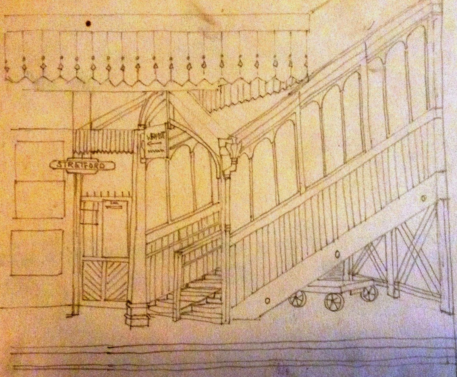
On Stretford Station with a bit of our railway past

It is 35 years since the last train ran from Stretford station which means that memories of a time before the tram will be fading

Stretford Station, April 1961
I briefly used the station back in the 1970s and had no idea of its history or the railway line.

It had been opened in 1849 by the Manchester South Junction and Altrincham Railway and was in part designed to transport food grown in Altrincham and Stretford into the heart of Manchester and in time would challenge the Duke's Canal as the main means of carrying heavy goods in to Manchester.

I have no doubt it would have created quite a stir.

The men who built the line were viewed at best with suspicion and at worst with fear.  They had a well deserved reputation for hard drinking and rough behaviour which is no surprise given the dangers of the work they undertook.

Central Station, April 1961
And there may well have been a few of  our farm a labourers who were taken on to do some of the least skilled work while some of our farmers and market gardeners would have taken advantage of the line to move their crops to the Manchester markets.

But its impact was also to start a wave of house building along Edge Lane.

The train offered the quickest way into town and allowed those who earned a living in the city to escape to what was still the countryside.

Of course by the time I used the train Edge Lane and the surrounding area had long lost any semblance of countryside, but the station still looked like an old fashioned railway, which is where my fiend Ann comes into the story.

She “found these the other day, tucked away. Stretford station in 1961, and Manchester Central, probably a similar date. I used to travel from Stretford to Oxford Road Station, spending my time on the journey drawing the other passengers.”

And so after sixty-two years a little bit of what an old railway station looked like is here to see again.

Now that is not so daft given that Stretford has become a Metro Stop with shiny yellow trams and Central having long lost its trains is now an Exhibition Centre.

Pictures; Stretford and Central Stations, April 1961 courtesy of Ann Love

Sunday, 10 May 2026

Mancunian Way ............. a little bit of excitement in 1967

Now I bet there will be more than a few people who would want to nominate this as one of the most boring picture postcards of all time.

But that would be so unfair, given that that the concept and construction was bold, leading the Manchester Guardian to comment that the “Mancunian Way is surprisingly good.  

The actual structure is extremely light and elegant in appearance”.*

And I am not going to disagree, with a civil engineering project which was ten years in the planning and construction and is as much a part of our past as the Town Hall, Free Trade Hall and Piccadilly Gardens.

That said and on its first day, fewer motorists used it than were expected, this was in the view of the Police because few people yet knew about it.

Location; Manchester

Pictures; The Mancunian Way, circa 1990s, from the collection of picture postcards of Rita Bishop

*Mancunian Way; will today be opened officially by the Prime Minister, Ashworth, Graham W, The Guardian, May 5th, 1965


Saturday, 9 May 2026

Just how much we forget …………….. Manchester ……. 1964

When you live in a place, it is easy to miss how it is changing.

This is Piccadilly in 1964, and I can remember going in all of those shops and standing at that bus stop.

More than half a century on, I can’t now tell you where we were going from that  bus shelter, or just when the buildings and their occupants changed, or for that matter whether I prefer the scene now or then.

Location; Manchester

Pictures; Manchester Piccadilly, 1964, 1964-0386 "Courtesy of Manchester Archives+ Town Hall Photographers' Collection"

Friday, 8 May 2026

So this is 1968 and we are looking up towards St Peter’s Square

I have to admit it is a scene which is very familiar and like all good pictures from the past I seem to remember it as monochrome.

Of course that doesn’t make sense but as hard as I try I can’t picture it in colour.

It is just one of those things.

And there will be plenty of others who instantly recognise the scene, even down to the fashionable dress and hairstyle of the young woman on the right.

The picture come to light through a new project which Neil Simpson tells me is “the Town Hall Photographer's Collection Digitisation Project, which currently is Volunteer led and Volunteer staffed is in the process of taking the 200,000 negatives in the collection dating from 1956 to 2007 and digitising them.

The plan is to gradually make the scanned images available online - initially on the Manchester Local Images Collection Website".*

And almost a century later I was pretty much on the same spot and chose to replicate the shot.

Of course at the time I had no idea that someone back in 1968 had stood where I was and taken a picture.

I bet even then the photographer would have had to be careful of the traffic while I had a clear run given that back in 2016 the road was closed as the finishing touches were being made to the tram line in readiness for the Second City Crossing.

Today I wouldn't dream of standing in the middle of the road, taking my time and then taking a picture.

The trams pass that spot with a frequency that means at best I might just get a shot in but I doubt it and that as they say is progress.

Still at least I can turn in a bright colour image.


And that just leaves you to record the differences.

Location Manchester


Picture; of looking towards St peter’s Square, 1968, courtesy of Manchester Libraries, Information and Archives, Manchester City Council, http://images.manchester.gov.uk/index.php?session=pass and almost the same spot in 2016 from the collection of Andrew Simpson


*Neil Simpson, Manchester Local Images Collection Website, https://www.flickr.com/photos/manchesterarchiveplus/sets/7215766350511542

Thursday, 7 May 2026

It’s how we did it ……… 1962 …… and a heap of adverts

Anyone who can remember the Colgate advert in the block of ice will know that adverts can date, and is a reminder of how they did things very differently in the past.


In some cases, it is the presentation of the advert, and in others it’s the underlying assumptions which in the 1960s just assumed that housework, cooking and being worried about your children was the preserve of women, and that anyone who was not English was open to be portrayed as a stereotype.


And so, with that in mind here are a collection of adverts from 1962.

Some are those big ones which required a man, a ladder, and a pot of paste, and came in parts, which had to be aligned perfectly.

Today those same hoardings are delivered electronically and change every few minutes.

And then there were the smaller ones, often advertising a newspaper or magazine which were changed daily.

All of which leads me to this collection.  

I have no idea where the pictures were taken but the presence of open spaces would suggest a part of the city undergoing a clearance programme or may be  just some of the bits Mr. Hitler’s bombs did for.


Either way the adverts are fascinating, not least because of the prices advertised, and also the stories being run in the newspapers, which included  a suspense serial in Reveille, entitled “No Chance In Hell” and “A girl called Johnnie, 20 Days in an Open Boat” from the Sunday Express.”

Reveille for those who don’t know was a popular weekly tabloid, which was launched in 1940 as the official newspaper of the Ex-Services’ Allied  Association, and after it was bought by the Mirror Group in 1947 settled into presenting light news story with an emphasis on entertainment.

And I suppose the fun will be to spot those brands and newspapers which are no longer with us, while for the eagled eyed reader there will be the surprising discovery that nearly 60 years ago we were just as likely to discard our litter as we do today.


Added to which as the shop next to the newsagents will testify, this was still a time when something broke you asked someone to mend it, rather than go off and buy new.

Finally there is the question of just where we were back in 1962.  

Enlarging the street sign above the newsagents offers up a number of possibilities, but all seem to fall by the wayside, as this was a road not a street and the listings in the directories show nothing that fits.

But then someone will know and come up with the answer.

Well I hope so.

And John Casey responded with "Rochdale Rd. My old area, moved out in 1963 as part of the slum clearance. The hoardings were erecred about 1958".

Location; Manchester

Pictures,  advertising in 1962, Manchester, 1962 -3554.1 and 1962 -3554.1, courtesy of Manchester Libraries, Information and Archives, Manchester City Council, http://images.manchester.gov.uk/index.php?session=pass


Wednesday, 6 May 2026

The image that defined the North

And not just the north but of working class communities across the country.

This scene is, I think Lower Byrom Street, but I could be wrong.

Location, Manchester, 1963

Picture; on the step, Manchester, 1963, Courtesy of Manchester Archives+ Town Hall Photographers' Collection, https://www.flickr.com/photos/manchesterarchiveplus/albums/72157684413651581?fbclid=IwAR35NR9v6lzJfkiSsHgHdQyL2CCuQUHuCuVr8xnd403q534MNgY5g1nAZfY

Tuesday, 5 May 2026

Lost on the streets of my city

Now one of the advantages of a misspent youth is that I am fairly familiar with the streets of Manchester.

From 1969 for three years as a student at the College of Knowledge on Aytoun Street I wandered the city between lectures.

Back then the library was for the studious and so after Mr Wilson’s lecture on contemporary Soviet Government and before Mr Ripley on the Chartists or Trevor Thomas on Andrew Marvel I was off exploring my adopted home.

It took me to the Art Gallery and the Ref along with the Town Hall, the warren of streets that is now the Northern Quarter and down to the very unfashionable Castlefeld.

That said the knowledge is a bit frozen in time and I didn’t really get back to looking for the historic the interesting and the bizarre until the start of the last decade.

But despite that knowledge, the maps, and the street directories this image has defeated me.

The picture come to light through a project which Neil Simpson tells me is “the Town Hall Photographer's Collection Digitisation Project, which currently is Volunteer led and Volunteer staffed is in the process of taking the 200,000 negatives in the collection dating from 1956 to 2007 and digitising them.

The plan is to gradually make the scanned images available online - initially on the Manchester Local Images Collection Website".

I think we are on West Mosley Street which was sandwiched between Cooper Street and Mosley Street and vanished sometime before now.

I am fairly confident that there will be lots of theories and if we are lucky the answer.

In the meantime I will ask my friend Andy to look up his 1969 street directory and try to identify the firm on the board above that white building.

We shall see.

Location Manchester

Picture; of Manchester, 1968, courtesy of Manchester Libraries, Information and Archives, Manchester City Council, http://images.manchester.gov.uk/index.php?session=pass 


Monday, 4 May 2026

Walking out on Oxford Street ............ 1966

I won’t be alone in remembering these buildings.


We are at the top of Oxford Street where it joins St Peter’s Square, and of the four buildings captured by the photographer on a drab day in 1966, all have gone.

Some went a long time ago, others more recently.

So, while the grimy looking one, home to Boots and which faced across the Cenotaph to Central Ref, was still there in 1969.

I remember gazing across it from the steps of the library but can’t quite remember when it was demolished for Elisabeth House which in turn was torn down for One St Peter’s Square.

More recently its neigbour, on the corner of Mosley Street and the square which many admired has been lost for that stark, and very bright building which is Two St Peter’s Square.

On the opposite side of Mosley Street, the properties on the left of the picture went became the peace Gardens and are now part of the space which includes platforms for the Metro and the reallocated cenotaph.

All of which just leaves me with the picture itself with its ghostly like figures caught in mid stride, and that sign for the restaurant “The Egg and I” which I never visited but which will be remembered by some.
Location; Oxford Street, Manchester

Picture; Oxford Street, 1966, Courtesy of Manchester Archives+ Town Hall Photographers' Collection,  https://www.flickr.com/photos/manchesterarchiveplus/albums/72157684413651581?fbclid=IwAR35NR9v6lzJfkiSsHgHdQyL2CCuQUHuCuVr8xnd403q534MNgY5g1nAZfY

Sunday, 3 May 2026

Walking Hulme and Moss Side over half a century ago ......

Now I have been a great fan of Roger Shelley’s photographs for over a decade, ever since he shared a collection of pictures he took of a group of young lads playing in the near ruin of Hough End Hall nearly 60 years ago.

The attention to detail and his ability to capture the moment are skills I wish I had.

And so, I was very pleased when he posted another group of images he took during the house clearances in Hulme and Moss Side.

The pictures are a mix of street scenes, and the people he encountered, including kids at play, men and women at work and the ever present piles of rubble as the grand plan advanced and centuries old houses disappeared under the impact of the wrecking ball.

Like the work of Shirley Baker* his pictures don’t dwell on sentimentality and don’t make judgments of the wholesale clearances of communities.

They just record what he saw.

I don't have exact locations for the images, but some can be traced through the odd street name or feature.

And with his permission I will be working my way through the portfolio, fastening on images which tell their own stories.

Location; Hulme and Moss Side in the 1960s and 70s


Pictures;  from the collection of Roger Shelley, https://www.flickr.com/photos/photoroger/

*Baker, Shirley, Without a Trace, Manchester and Salford in the 1960s, 2018

Knocking down bits of Wilbraham Road .... in the summer of 1963

Now the next time you are in the Co-op on Wilbraham Road, spare a thought for the buildings that once stood on this spot.

They consisted of two tall residential properties, which like their neighbours stretching up towards Whitelow Road had been converted into shops with living accommodation above.

Our two were replaced by the building rising from the ground in 1963.

And for a long time I had just taken for granted that the whole modern block of shops had been built at the same time.

But not so, as the picture indicates, and taking a walk down Wilbraham Road from Brundrettes Road, it is possible to see the change in design and date.

So you learn something new, all the time.

Location; Chorlton

Picture; Wilbraham Road, 1963, Courtesy of Manchester Archives+ Town Hall Photographers' Collection,  https://www.flickr.com/photos/manchesterarchiveplus/albums/72157684413651581?fbclid=IwAR35NR9v6lzJfkiSsHgHdQyL2CCuQUHuCuVr8xnd403q534MNgY5g1nAZfY

Saturday, 2 May 2026

The 42 from the Refuge Building …..a furniture shop, Wimpy Bar, and a shed load more …..1967

Now, with the passage of a full half century, it is the detail you forget.

I stood at the bus stops outside the old Refuge Building for years, and never gave much thought to the building opposite.

Back then it was just a furniture shop, and as I was a first year student on a grant, living in a series of drab and worn out  bed sits I gave Shaw’s Furniture shop scant attention.

And likewise I don’t think I ever went in the cinema round the corner, or took a train from Oxford Road Railway Station, and gave no attention to the features of the Refuge Building behind me.

It would be years before I went in to the former furniture shop, and only after it had become the Cornerhouse which was an art gallery, cinema, bookshop, bar and café, with superb views up Oxford Street, and some pretty interesting films which you would never see at the Odeon.

Likewise my discovery of the railway station with its wonderful 60s entrance would be delayed for a few years, and instead I fastened on the Oxford Road Corridor from town to Withington.

Which also meant that the hospital opposite Shaw’s, along with the kiosk which announced “You Are Safe With The Oxford Rubber Goods” was just a blur from the window of the 42.

Nor do I think I ever went in the Wimpy, which has over the decades changed its name and the food on offer.

And now, Shaw’s is No. 70, the Refuge Building is a hotel, and the kiosk became Euronews, although last time I passed it all seemed closed up.

But I still use Oxford Road Station and marvel at that entrance.

Location; Manchester

Pictures; Shaw’s, and the Wimpy, 1967, "Courtesy of Manchester Archives+ Town Hall Photographers' Collection", https://www.flickr.com/photos/manchesterarchiveplus/albums/72157684413651581?fbclid=IwAR35NR9v6lzJfkiSsHgHdQyL2CCuQUHuCuVr8xnd403q534MNgY5g1nAZfYand Oxford Road Railway Station, 2009 from the collection of Andrew Simpson

Thursday, 30 April 2026

The lost Hulme and Moss Side

Now I have been a great fan of Roger Shelley’s photographs for over a decade, ever since he shared a collection of pictures he took of a group of young lads playing in the near ruin of Hough End Hall nearly 60 years ago.

The attention to detail and his ability to capture the moment are skills I wish I had.
And so, I was very pleased when he posted another group of images he took during the house clearances in Hulme and Moss Side.

The pictures are a mix of street scenes, and the people he encountered, including kids at play, men and women at work and the ever present piles of rubble as the grand plan advanced and centuries old houses disappeared under the impact of the wrecking ball.

Like the work of Shirley Baker* his pictures don’t dwell on sentimentality and don’t make judgments of the wholesale clearances of communities.
They just record what he saw.

I don't have exact locations for the images, but some can be traced through the odd street name or feature.


And with his permission I will be working my way through the portfolio, fastening on images which tell their own stories.


Location; Hulme and Moss Side in the 1960s and 70s

Pictures;  from the collection of Roger Shelley, https://www.flickr.com/photos/photoroger/

*Baker, Shirley, Without a Trace, Manchester and Salford in the 1960s, 2018