Showing posts with label Chorlton Roads. Show all posts

Thursday, 10 July 2025

House Yard Road ...... the one we lost

It’s the cut through from the village green down to the Bowler we all use.

House Yard Road, 2023

Or at least we use when we don’t want to walk on the gravestones in the graveyard, or fancy chancing the narrow pavement along St Clements Road.

That said its not always the most enticing cut through.  

In winter it can be wet, muddy and slippery under foot while in high summer the vegetation can be a challenge as it stretches out across the path.

For most people that is it, but for those of us a tad older, its northern end did have that telephone kiosk which once had stood on the green.

X marks House Yard Road, 1845
And like most of us I took it for granted as just an unnamed strip of land which over the years had become an unofficial path.

But not so, because it did have a name, and it did lead somewhere other than the Bowling Green Hotel.

For this was House Yard Road and it led to the farmyard and barn of William Knight, or it did in 1845.  

By the early 20th century the farm had gone but the site was home to a collection of workshops and lock up garages, until thy all vanished to make way for Finney Drive in the 1960s.

The Knight family farmed in the township from at least 1832, and farmed enough land to qualify for a vote in Parliamentary elections at a time when the entire electorate of Chorlton was just 32 men out of a total population of about 750.

In 1845 William Knight rented 72 acres land from the Lloyd estate, which marked him out as one of the more prominent farmers.  His land was a mix of arable, pasture and meadow land spread out across the township.

His son ran the Robin Hood pub in Stretford, before moving into the township to farm on the green in the 1850s after the death of his father. 

House Yard Road, circa 1910
He is also on the electoral register for 1854-55, can be found in the minutes of the Vestry or Ratepayers and was part of the inquest held at the Horse and Jockey into the murder of Francis Deakin and he was buried in the family grave in the parish church yard.

And earlier in 1824 a Thomas Knight was listed in Pigot and Dean’s Directory of Manchester & Salford as “vict Old Greyhound, (boat house) Chorlton”, and Martha Knight was listed in Baines’ Directory for 1824-5 as running the “Boat House” in Chorlton.  This later became the Old Greyhound and still the Bridge Inn and today is Jackson’s Bridge. 

All of which means that House Yard Road will have been a busy place, and walked over by the Knight family, along with their agricultural labourers and perhaps heaps of others making their way to the Bowling Green Hotel, or the pond beside the pub to do a bit of illicit fishing.

So, our little cut through has indeed some history.

Location; that cut through beside the old parish graveyard

House Yard Road, so good we included it twice 2023

Pictures; House Yard Road, 2023 from the collection of Andrew Simpson, and circa 1908 from the Lloyd Collection, and in 1845 from the map of the Tithe Schedule

Sunday, 29 September 2024

Today I walked the old road ........ part two

The road twists and turns following the old field divisions and natural obstacles before running up beside the river bank.

Junction of the Gore [Chorlton] Brook, 1963
This was our first warning of the power of the Mersey. For here there is no gentle river bank sloping down to the water’s edge.

 Instead the road hugs a towering bank built and added to over the centuries as the main defence against a powerful threat to the lives and livelihoods of all those who lived beside it. Generations of farmers have laboured to construct this natural wall to repel the flood waters of the Mersey.

The village and the isolated farms were all built beyond the flood plain. Even so this was not always sufficient protection. The Mersey has on countless occasions risen and breached these towering banks sometimes even sweeping away the defences themselves.

It was for this reason that the weir was built. Just beyond the point where the Brook joins the Mersey and at a bend in the river the weir was built to divert flood water from the Mersey down channels harmlessly out to Stretford and the Kicketty Brook.

Not that it always worked. Soon after it had been built flood water swept it away and during the nineteenth century neither the weir nor the heightened river banks prevented the Mersey bursting out across the plain.

 In July 1828 the Mersey flood water transported hay ricks from the farm behind Barlow Hall down to Stretford only later to bring them back, while later floods proved to be even more destructive. It was, wrote Thomas Ellwood the local historian
“no uncommon thing to see the great level of green fields completely covered with water presenting the appearance of a large lake , several miles in circuit.”


Painting; Junction of Gore Brook and River Mersey, 1963, M80140, courtesy of Manchester Libraries, Information and Archives, Manchester City Council, http://images.manchester.gov.uk/index.php?session=pass

Montogomery is incorrect, at the point where it joins the Mersey it has become Chorlton Brook

Saturday, 28 September 2024

Today I walked the old road .......... Part One

Today I walked the old road.

It is little more than a narrow paved track but for centuries it was one of the main routes out of the village to Manchester. Along this road went the farmers with their wagons loaded with agricultural produce destined for the Bridgwater Canal, villagers wanting to join Chester Road which led on into Manchester, and cowmen driving their cows back from the Meadows to the farms around the Green.

It was called Back Lane and it started by Hardy Lane ran down past the parish church, across the Meadows and ended just beyond the Duke’s Canal. Over the years parts of the road have changed their name and there are now houses along some of its course. Our chosen route would take us from the green past open land all the way to Stretford.

In some ways little appears to have changed in the last 150 years. Just as then hawthorn, oak, hazel and ash trees line the road and the banks made from countless years of leaf deposits trapped under the hedgerows are still there. My companion pointed to hazel trees which showed evidence that they had once been coppiced. It is a skilled job and one that I guess had not been undertaken here on our road for perhaps half a century.

In the distance rooks swooped back and forth, around their nest. Nothing quite prepares you for one of these. High up in the bare branches they seem as natural apart of the tree as the branches themselves. And there, just past Sally’s pond stood the old oak tree, perhaps the tallest tree on our road. More than likely those bringing the news of Nelson’s victory at Trafalgar would have passed it on their way into the village as would an obscure soldier fired by missionary zeal to preach the Methodist message.

Picture; the old road from the collection of Andrew Simpson

Friday, 27 September 2024

Saving the odd old road sign ....................... another street furniture story

Well it had to happen ............. the one bit of street furniture I have consistently ignored, so here is the start of a series on the humble road sign.

I say road sign because as everyone one knows, Chorlton-cum-Hardy never did streets, just roads.
I rather think a “street” might have crept in with all that new development over the years and we did have our own Lloyd Street back in the mid 19th century but that is it.

And of course more recently there has been the renaming of roads.

But for now I just want to focus on the road sign like this old traditional one on just round the corner from us.

You can still see them on the sides of buildings but they are in decline, replaced by the easier to read but a bit bland version of today.

And while I am on it perhaps a supplementary series could be the road/street names themselves.  Most are in memory of long gone local heroes, like Mr Brundrett, Mr Needham and of course those big landowners, the Egerton’s and Lloyds.

But sometimes the odd names strike you, like Ney Street in Waterloo in Ashton which I will leave you to ponder on, given that Marshal Ney was one of Napoleon’s generals and Napoleon of course was defeated at Waterloo.

Or Battle of Tel el- Kebir Street in Sunderland or the equally imaginative Faucet Street in the same town and our own Anita Street which more than a few people will be able to furnish the full story.

So that is it ............ road signs the new series to sit beside the other street furniture series, which include, finger posts, water troughs telephone kiosks and pillar boxes, not forgetting those huge iron street ventilation pipes.


That said my old friend in Adam in Peckham has started the research going, so lots I suspect still to come.

Location; Chorlton-cum-Hardy

Picture; Provis Street, 2016 from the collection of Andrew Simpson

Thursday, 26 September 2024

The Old Road in the 1890s


Now the Old Road has always been special to me. 

It ran from Hardy Lane down past the Brook into the village by the church and then off across Turn Moss to Stretford.

Over the years it has had many names and bits of it have been renamed from time to time.

Strictly speaking it was never known as the old road for there are equally old roads, lanes and track ways which ran out of the township.

But unlike the others it has retained much of its rural character.  True if you start at Hardy Lane you are presented with a modern road followed by the “stumps” which lead into the ville and the stretch past the school, round the church and along Ivygreen Road is pretty urban, but where it becomes Hawthorn Lane it still has the power to transport you back to the early 19th century.

Here it becomes a narrow twisty lane with the remains of hedges along its path, the 18th century weir clearly visible through the trees and finally the raised platform underneath the canal built to protect travellers from the farm wagons passing on their way to Stretford.

All of which makes this picture and those to follow over the next few weeks rather special.  They capture something of the charm and magic of the old road.  This one is from around 1890.  Despite the fashions of the couple staring at the camera which dates it to the late 19th century it could be any time over the last few hundred years.

The horse and cart add to the almost timelessness of the image, but hard by where the road ran into Stretford was a modern railway line, and just over a mile and a bit in the other direction was new Chorlton with its rows of recently built houses catering for the middling people who travelled into town from the newly opened Chorlton train station but still lacked the idea of living on the edge of the countryside.

Location;Chorlton

Picture; from the Lloyd collection

Tuesday, 24 September 2024

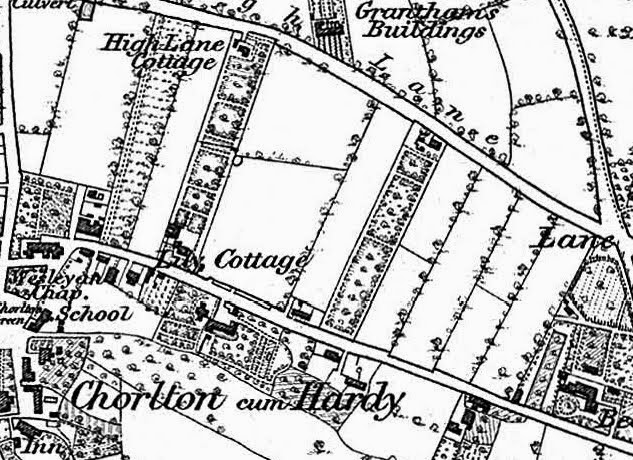
Who stole all of Chorlton's streets?

 Now for all those who never tire of telling the assembled crowd that Chorlton has no streets but only roads, it might be a revelation that this was not always so.

Cross Road, 2018
Acres Road was once Acres Street, while the small stretch of road from the Chorlton Green past the Beech Inn to where there is a twist in the direction of the road was Lloyd Street.

Added to this the Rate Books  show that Cross Road underwent a number of name changes, beginning with Cross Lane, then Cross Street and finally Cross Road.

And nor has Beech Road always been a road, in fact it only became a road in the mid 1870s.

Before that, stretching back the centuries it was Chorlton Row.

Just why we came to prefer road to street is unclear, but it wasn’t always so.

One explanation might be the the swift urbanization of Chorlton from the 1880s onwards, which within two generations transformed the area from a small rural community to a suburb of Manchester.

The coming of mains water, a gas supply and later a railway station made Chorlton ripe for development.

And many of those who came were the "middling sort" who worked in the city and wanted a sort of rural place to come home to

Lloyd Street running north from the Green, 1854
Many of them of them were professionals, or managers, with a strong representation from clerical occupations, and perhaps the draw for them was a "road" not a "street".

It was as the Manchester Evening News commented in the September of 1901 so swift a development that “the green fields of one summer are the roads and avenues of the next.”*

And something of just how quickly the roads and avenues appeared can be got from the street directories for the early 20th century.  

These were not unlike our telephone directories in that they listed the householder in each road, street and avenue, with the added bonus that they often give the occupation.

Location; Chorlton

Picture; Cross Road, 2018, from the collection of Andrew Simpson, and Lloyd Street, 1854, from the OS map of Lancashire, 1854, courtesy of Digital Archives Association, https://digitalarchives.co.uk/

*Manchester Evening News September, 1901

More stories

Looking out from Cross Lane ....... across the fields of Chorlton-cum-Hardy with Mr Samuel Walton, https://chorltonhistory.blogspot.com/2020/06/looking-out-from-cross-lane-across.html

Looking for Lloyd Street ........... the lost roads of Chorlton part 2, https://chorltonhistory.blogspot.com/2019/08/looking-for-lloyd-street-lost-roads-of.html


Friday, 22 March 2024

Slow day in Chorlton ..........

It was a quiet time on Beech Road.


The kids were at school, the commuters were well and truly on their way, leaving just the odd delivery van a couple shopping for a late breakfast and me.

The Lead had yet to open, Etchells, and the Chemist had a few visitors,  leaving me to take a some pictures.

And to reflect on the history of the place.

The Lead as everyone knows was a former police station, the Etchell’s family maintain the continuity of a newsagents which stretches back to the beginning of the last century, and the Chinese takeaway resides in a premise which has an unbroken history of selling fish and chips from when Queen Victoria was on the throne.

Which only leaves me to report that until the 1870s this road was called Chorlton Row and is a pretty old thoroughfare connecting Barlow Moor Lane with the village green.

Stand in the middle of the road  in the early morning before most of the cars have arrived and you can see its twisty turny path which once would have accommodated  the natural obstacles of trees, Blomley's fish pond and field boundaries.


Location; Beech Road

Pictures; Beech Road, 2024, from the collection of Andrew Simpson


Wednesday, 20 March 2024

Coming soon ….. The Streets of Chorlton

The Simpson & Topping partnership are working on a new series of books which will explore the stories behind the doors of some of our most loved places.


And along the way will challenge that widely held belief that there are no streets in Chorlton which is an idea that regularly floats across social media and pops up in the odd pub quiz.

To be fair the last “street” disappeared over a century and a bit ago, but they did exist, can be found in the historical records and were once well known.

Names like Chorlton Row, Lloyd Street, Cross Street, Back Lane and House Yard Road have long since vanished from living memory but along with Pitt Brow and Lane End they were places where people lived.

Chorlton Row [Beech Road] 1854
So, the series will start with the ever-popular Beech Road which for centuries was just a twisty turny rural lane connecting Chorlton Green with Barlow Moor Lane.

Had you walked it in say 1850 you could have marvelled at the few posh houses along its path, caught a glimpse of old Mr. Gratrix in his farm house, chatted with Mrs Sutton in the garden of her thatched wattle and daub cottage and stayed to gaze at the blacksmith engaged in the magic of heating and hammering.

Throw in a pint in the Traveller’s Rest which was a modest beer shop almost facing the village green and you pretty much had the lot.

Andrew has begun writing the stories behind the doors and Peter is busy sourcing previously unknown old pictures as well as painting a few new ones.

If you think your road, lane, close or avenue has a story do let us know.

Location; Chorlton

Picture; Peter’s painting based on a photograph of Beech Road, from the early 20th century, Chorlton Row, 1854, from the OS map of Lancashire, 1854, courtesy of Digital Archives Association, http://digitalarchives.co.uk/

Thursday, 2 June 2022

Who stole Chorlton's Street?

Now for all those who never tire of telling the assembled crowd that Chorlton has no streets but only roads, it might be a revelation that this was not always so.

Cross Road, 2018
Acres Road was once Acres Street, while the small stretch of road from the Chorlton Green past the Beech Inn to where there is a twist in the direction of the road was Lloyd Street.

Added to this the Rate Books  show that Cross Road underwent a number of name changes, beginning with Cross Lane, then Cross Street and finally Cross Road.

And nor has Beech Road always been a road, in fact it only became a road in the mid 1870s.

Before that, stretching back the centuries it was Chorlton Row.

Just why we came to prefer road to street is unclear, but it wasn’t always so.

One explanation might be the the swift urbanization of Chorlton from the 1880s onwards, which within two generations transformed the area from a small rural community to a suburb of Manchester.

The coming of mains water, a gas supply and later a railway station made Chorlton ripe for development.

And many of those who came were the "middling sort" who worked in the city and wanted a sort of rural place to come home to

Lloyd Street running north from the Green, 1854
Many of them of them were professionals, or managers, with a strong representation from clerical occupations, and perhaps the draw for them was a "road" not a "street".

It was as the Manchester Evening News commented in the September of 1901 so swift a development that “the green fields of one summer are the roads and avenues of the next.”*

And something of just how quickly the roads and avenues appeared can be got from the street directories for the early 20th century.  These were not unlike our telephone directories in that they listed the householder in each road, street and avenue, with the added bonus that they often give the occupation.

Location; Chorlton

Picture; Cross Road, 2018, from the collection of Andrew Simpson, and Lloyd Street, 1854, from the OS map of Lancashire, 1854, courtesy of Digital Archives Association, https://digitalarchives.co.uk/

*Manchester Evening News September, 1901

More stories

Looking out from Cross Lane ....... across the fields of Chorlton-cum-Hardy with Mr Samuel Walton, https://chorltonhistory.blogspot.com/2020/06/looking-out-from-cross-lane-across.html

Looking for Lloyd Street ........... the lost roads of Chorlton part 2, https://chorltonhistory.blogspot.com/2019/08/looking-for-lloyd-street-lost-roads-of.html


Monday, 15 June 2020

So why did Chorlton turn its back on streets and opt for only roads? ......... with the exception of a few lanes, and closes.

Now for all those who never tire of telling the assembled crowd that Chorlton has no streets but only roads, it might be a revelation that this was not always so.

Cross Road, 2018
Acres Road was once Acres Street, while the small stretch of road from the Chorlton Green past the Beech Inn to where there is a twist in the direction of the road was Lloyd Street.

Added to this the Rate Books  show that Cross Road underwent a number of name changes, beginning with Cross Lane, then Cross Street and finally Cross Road.

And nor has Beech Road always been a road, in fact it only became a road in the mid 1870s.

Before that, stretching back the centuries it was Chorlton Row.

Just why we came to prefer road to street is unclear, but it wasn’t always so.

One explanation might be the the swift urbanization of Chorlton from the 1880s onwards, which within two generations transformed the area from a small rural community to a suburb of Manchester.

The coming of mains water, a gas supply and later a railway station made Chorlton ripe for development.

Lloyd Street, 1854
And many of those who came were the "middling sort" who worked in the city and wanted a sort of rural place to come home to

Many of them of them were professionals, or managers, with a strong representation from clerical occupations, and perhaps the draw for them was a "road" not a "street".

It was as the Manchester Evening News commented in the September of 1901 so swift a development that “the green fields of one summer are the roads and avenues of the next.”*

And something of just how quickly the roads and avenues appeared can be got from the street directories for the early 20th century.  These were not unlike our telephone directories in that they listed the householder in each road, street and avenue, with the added bonus that they often give the occupation.

Location; Chorlton

Picture; Cross Road, 2018, from the collection of Andrew Simpson, and Lloyd Street, 1854, from the OS map of Lancashire, 1854, courtesy of Digital Archives Association, https://digitalarchives.co.uk/


*Manchester Evening News September, 1901

More stories

Looking out from Cross Lane ....... across the fields of Chorlton-cum-Hardy with Mr Samuel Walton,
https://chorltonhistory.blogspot.com/2020/06/looking-out-from-cross-lane-across.html

Looking for Lloyd Street ........... the lost roads of Chorlton part 2, https://chorltonhistory.blogspot.com/2019/08/looking-for-lloyd-street-lost-roads-of.html

Thursday, 6 March 2014

That stables on Stockton Road, soon to be no more

The lock up on Stockton Road which was a garage has been sold.

Now I know this because Andy Robertson has sent me a series of pictures of the place and as you do I have been drawn into its history.

It is a building I have often wondered about but until now have not bothered to look up.

But I guess now that the sold sign has gone up its days are numbered and like other buildings Andy has recorded over the last few months this one will soon be gone.

It looks to have once been a stable, with the hay stored at the top and the horse and carriage below. It is just possible to make out on the south elevation what would have been the entrance in the first floor for loading the hay into the building, and inside there would have once been a hatch to drop the hay down to ground level.

To the left the old entrance to the coaching area is still visible as is the half bricked up door giving access to the stables.

For as long as I can remember the building has been a motor repairs business, but despite being curious I never knocked on to get a look inside.

And that is another timely reminder that when in doubt investigate.

Now I didn’t so all I am left to do now is to search for its past.

I can’t be sure when it was built but it was there by 1894 and could already been there by the 1840s.

In 1841 it may have been the stables for what I think was the home of a Mary Dunster which stood directly behind it.

But the house has long gone, and to the north of our stables by 1891 were numbers 59 and 57 High Lane.

These were private residences until the beginning of the 20th century when they became a private school with number 59 being converted by 1903 and incorporating its neighbour soon after.

All of which is a tad intriguing because the owner of the school was Miss Annie Booth who lived with her family on Manchester Road.

Her father was Aaron Booth who took some of the early photographs of that end of Chorlton in 1882.  They lived in Sedge Lynn which was demolished for the cinema in 1919.

Now Annie Booth described herself as a school teacher in 1891 and her father was well off enough to help fund the "school for girls" on High Lane and a decade later and she is down on the 1901 census as an employer.

But Mr Booth had died in 1912 Miss Booth was no longer the owner of the school which was now owned by Charles Dadly MA and specialised in training for "Law, Medical Accounts prelims, University, Civil Services Exams" and more.

All of which is a powerful reminder of the large number of private schools in Chorlton.

As for Annie I rather think she continued to live in Chorlton long enough to donate her father’s photographs to John Lloyd the local historian.

All of which is a long way I know from Andy’s picture.

Pictures; Stockton Road March 2014 from the collection of Andy Robertson, detail of High Lane from the OS map of 1841, courtesy of Digital Archives Association, http://www.digitalarchives.co.uk/ and extract from Slater's Manchester, Salford and Suburban Directory 1903

Thursday, 8 December 2011

Today I walked the old road ........ Part Five


Journeys end was the Duke's Canal. But what the canal had been to the late eighteenth century the railway was to the nineteenth. After all as one writer said they were a device for making the world smaller, and their impact was immediate,
“..swifter than a bird flies … you cannot conceive what the sensation of cutting the air was; the motion is as smooth as possible …when I closed my eyes, this sensation of flying was quite delightful and strange beyond description…”
Not that most of the people travelling on our road would have been able to afford the prices on the railway. Later, train fares did come down but in the early years of the Manchester South Junction & Altrincham Railway the people of Chorlton and Stretford might wonder at its brash speed and magnificent power but could only look. They might however have been employed on building it because while the really skilled work was done by navvies there was still casual employment for local farm labourers. Some may even have worked on the bridge which took the railway over the old road.

It still makes for an impressive sight, the two forms of transport which not only assisted in transforming the Industrial Revolution but which were about to wrench Chorlton out of centuries of isolation. The station at Stretford brought people with money who began to buy houses along the route from the station towards the village. Thirty years later another railway line with its station on the edge of the village was going to spark a second building boom on land which had been agricultural.
Picture; replica of the locomotive Planet 1830, from the collection of Andrew Simpson

Wednesday, 7 December 2011

Today I walked the old road ......... Part Four

Our walk terminates at the Duke’sCanal which was built in 1765 to ship coal from the mines of Worsley to the homes and factories of Manchester. So successful was the venture that the price of coal dropped and the Duke was assured a handsome return on his investment. It also carried farm produce into the city and here at Stretford in 1849 the canal helped carry 873 tons of produce which rose a year later to 1,783. Much of this would have been food and much must have come by way of our road from Chorlton. It was a two way traffic with barges bringing night soil from the city to use on the farms.

The building of the canal would have both fascinated and struck terror into the surrounding local villages. The navvies who built the canals and went on to build the railways were tough often violent men who sometimes accepted part payment in alcohol. Many local people went in fear until the men moved on. They lived in temporary camps beside the canal and according to many contemporary accounts were lawless places.

What is certain is that our road became that much busier as more heavy traffic made its way from Chorlton under the canal bridge. And this might explain the raised pavement under the tunnel. Nowhere else did we encounter a pavement and I suppose out on the open road if faced with a heavy farm cart the traveller could jump into a nearby field. But here under the canal no such option was possible and a raised pavement offered protection.

Standing under this canal we reflected on the sheer volume of water above our heads. But then Cut Hole Aqueduct had successfully held that water in place for over 240 years so why should we worry?
For those with money who had travelled down our road it was possible to take the passenger boat into Manchester. In 1841 the cost from Stretford to Manchester was 6d for a front room and 4d for the back room.

“They were fitted up with large deck cabins, surrounded by windows, .... so that a person could be under cover and see the country. They were drawn by two or three good horses at the rate of six miles an hour.”

Having arrived at the canal, passengers could wait in the Watch House. Here an employee would watch for the passenger boat and ready the fresh horses so that little time would be wasted in the changeover.

Tuesday, 6 December 2011

Today I walked the old road .......... Part Three

We had been following the old road and been talking about the massive earthworks which protected us from the Mersey. In a further effort to curb the river and control the ever present danger of flooding they built a weir in the bend of the Mersey just beyond where Chorlton Brook flows into the river.

On a cold bleak and rain swept morning it was possible to sense the importance of the weir. Stretching out from the wall was a deep and placid pool of water home to ducks and broken by bunches of water plants. 

But with just a little imagination how different it might have been on a stormy night when the river swollen with rain water burst over the weir. And almost on queue my companion talked about his own scary moment earlier in the year when after what seemed to be weeks of rain the river rose and topped the protective banks, leaving him scrabbling for safety. And indeed these historic floods were quite sudden. One such event left a farmer just enough time to release his horses from the cart and stamped them to higher ground, while on another occasion one man was forced to take refuge in a birch tree till the following morning. As destructive as these floods were they did deposit silt from the river onto the land which the farmers prized. In normal times it was the practice to “open the sluices or floodgates in order to get the advantage of such sewage upon the land as the river affords, thus saving the trouble and expense of carting ‘management’ there.” Later as our walk took us along the banks of the Mersey we walked through flood silt which had been left by the river earlier in the year when it had nearly topped the bank.

Painting;Higginbotham's field in flood 1946, painted in 1963, J Montgomery m80092 Courtesy of Manchester Libraries, Informationand Archives, Manchester City Council.