Now, if you were born in the first half of the last century then discarded tyres will have been a familiar plaything.
 |
| One tyre and a frozen lake, 2025 |
They were usually to be found on bomb sites of which there were still plenty where we lived in the 1950s.
 |
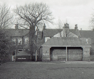
| The lost shelter, 1979 |
Of course, tyres remain a go to thing for kids, and those left on the Rec are put to good use.
Relics come in many different forms and the word Rec itself is now a relic, used by those who remember the two-acre ground on Beech Road before it got its upgrade to “Park”.
I can’t remember when that transition happened, and I wonder how long the original name will survive in living memory.
But the Rec or Recreational Ground is how it started out in 1896, was recorded as such in official records during a big chunk of the twentieth century, and so it is the name still used by many in Chorlton.
 |
| 101 uses for the Rec, 1979 |
Because it was opened in 1896 along with the restored village green and was less a park and more a recreation ground with benches, flower beds and a selection of play furniture. These were later joined by a bowling green.
To which in 1940 was added a large condrete slad with mooring hook for a barage balloon.
The ballon left the Rec at the end of the last war but the concrete slab was still there in the north eastern corner well into the 1980s.
But if the name Rec still lives on that of Old and New Chorlton have now vanished from common usage.
Once before the housing boom of the 1880s there was no distinction, but with rapid development around the junction of Wilbraham and Barlow Moor Roads the old hamlet of Martledge was lost, people began referring to the New Town/village and the old one. The New had the shops, some banks, and the new houses, as well as the railway station.
Old Chorlton was the village green and Beech Road which was the traditional centre of the rural community. The distinction was still in use in the 1970s and lingered on in the conversations of a few well into the 2000s.
 |
| The Rec, Beech Road and our house, circa 1930s |
Leaving perhaps just the locations of Scotch Hill, Lane End and Brundrette’s Corner.
They too have vanished from common usage, but each had a historic origin and each can also be found on the blog or that wonderful book, The Story of Chorlton -cum- Hardy.*
Location; Chorlton
Pictures; The Rec, 1979-2025, from the collection of Andrew Simpson, aerial photograph of Beech Road , circa 1930s-1940s,courtesy of Britain from Above, EPW 017620, courtesy of Manchester Libraries, Information and Archives, Manchester City Council, http://images.manchester.gov.uk/index.php?session=pass
*The Story of Chorlton-cum-Hardy, https://chorltonhistory.blogspot.com/2014/12/the-story-of-chorlton-cum-hardy.html
**A new book for Chorlton, https://chorltonhistory.blogspot.com/search/label/A%20new%20book%20for%20Chorlton
No comments:
Post a Comment