Sunday, 5 April 2026

By train from Chorlton into the Hope Valley in the April of 1957 for a day of rambling


Now it is Sunday April 7th 1957 and I am on Chorlton railway station waiting for the train from Central which left at 9.45 am and is due here just twelve minutes later.

The weather according to the forecast is promising, for “after frost at first, areas will have a fine, mainly sunny day, with normal or slightly higher temperature”* which will gives us about 8⁰C or a little bit more.

And that I reckon is just right for a ramble in the countryside which is what we would have been planning to do on that April morning back in 1957.

This I know from a delightful poster which British Railways published in that year**  advertising Special Excursions to Chinley, Edale, Hope, Bamford and Hathersage.

It is of course a journey that can no longer be made by rail, but back in 1957 our station still had another ten years before it was closed and there are quite a few people who remember making the trip into the Hope valley by train from Chorlton.

All of which makes the poster a valuable piece of history, for not only do we have the journey times for this long vanished service but also the cost.  So from Chorlton it cost 4/3d for a return ticket to Hope and took just 19 minutes.

These were “organised rambles, with leaders provided, details of the routes to be taken and walks for both individuals and parties.”

So having done the ramble the train back would have left Hope at two minutes past seven arriving back in Chorlton at about 8.10 in the evening.


It is a journey I would have loved to have made, not least because it was while in Hope recently that we decided to take up serious walking.  But sadly back in 1957 I was just eight years old and living in London.

Still this little poster gives a flavour to what was on offer back then and an insight into our own railway line.

*The Observer April 7th 1957

**Special Excursions to Chinley, Edale, Hope, Bamford and Hathersage, from Manchester Railway Termini, E.M.Johnson, Foxline Publishing,  1987

Picture; from Manchester Railway Termini, E.M.Johnson, Foxline Publishing,  1987


What a difference 47 years can make ........ The Rochdale Canal transformed

Forty-seven years is a pretty big chunk of any one’s life and in my case falls short of the six decades I have lived here in the city.

It is also the space between the pictures taken by a young art student and roughly the time I revisited the place with some of my own.

The canal was finished in 1804 and ran for 32 miles across the Pennines from the Duke’s Canal at Castlefield Basin to join the Calder and Hebble Navigation at Sowerby Bridge in West Yorkshire. In his description of the canal network published in 1830 Priestley was in no doubt of the canal’s importance.

"The canal is one of the main links in the chain of inland navigation between the east and west seas, being made for vessels of such size as enables them to navigate the tide way, and to pass between Liverpool and Hull without the expense of reshipping their cargoes, thus affording great advantages to the populous towns of Manchester, Rochdale, Halifax, Wakefield and other son the banks of the intermediate rivers. The Baltic produce can thus be readily conveyed into Lancashire and the manufacturers of Lancashire in return exported through the ports of Goole and Hull to Hamburg, Petersburg, Lubeck and other continental markets. The stone from Cromwell Bottom and its neighbourhood is hereby also conveyed to Rochdale and Manchester. These connections are likely to make it ultimately an undertaking of considerable profit to the proprietors.”*

So our own international highway and one that carried everything from “corn, timber, woollen cloth, coals and raw materials.” But like all our canals find it difficult to compete with the railways and finally closed in 1952, although the section through the heart of the city from Castlefield to Piccadilly proved profitable and stayed open.


Location; the Rochdale Canal


Pictures; from the collections of Eileen Blake and Andrew Simpson , map of the canal network around Manchester from Bradshaw’s map of 1830, The Inland Navigation of England and Wales, and the extract from Joseph Priestley’s Historical Account of the Navigable Rivers, Canals, and Railways, 1830 courtesy of Digital Archives http://www.digitalarchives.co.uk/ 

* Priestley, Joseph, Historical Account of the Navigable Rivers, Canals, and Railways, 1830, Page 579

One of those scenes of the High Street that has passed out of living memory

This is another of those scenes of our High Street which I suspect has long faded from living memory.

We are standing a little past the junction with Well Hall Road, looking east and the grand house in the centre of the photograph is Sherard House.*

It went in 1923 when the Nat West Bank was built on the site and was followed by the Congregational Church which made way for that large and grand shop which was Burton’s in 1937.


It is a wonderful image because it takes us back to that time when the  big houses of the people with plenty dominated the High Street.

Most have now gone but a few are left, although all have been much knocked about.

*Sherard House and Church Row in Eltham in 1841 and Richard White census enumerator,
Picture; courtesy of Kristina Bedford from her new book Eltham Through Time, Amberley Publishing, 2013,


Saturday, 4 April 2026

Easter on the Rec ……

Now I have lived across from the Rec for half a century, and I never tire of the place*.


It has hosted concerts, the Beech Road Festival, heaps of impromptu football matches between our three kids and loads of their friends and is one of the go to places for our grandchildren.

And because it is special I regularly return to it exploring its history and just taking pictures of how it has changed over the years. **

There will now be no one who remembers the recreation ground being opened 130 years ago but there will be plenty with fon memories of the bowling green, the old fashioned see saw, and the years when it lost its railings.

And for some it is remains a test of just how "Chorlton" you are, becuause  if you refer to it as the "Rec" then you can claim to have been in here long enough to be regarded as Chorlton.  

For every one else who know it only as Beech Road Park that could be a mark of how far you still have to travel.

Our three always call it the Rec and why not, given that all were grew up opposite it from birth and our Saul was actually born upstairs in the big front room overlooking the place.


Of course such a judgement could be regarded as pure tosh and what counts is how much you like Chorlton and especially Beech Road.


And that is it.

All of which is an introduction to a series of photographs I took a few days ago.

Location; Beech Road

Pictures; Easter on the Rec, 2026, from the collection of Andrew Simpson

*The Rec, https://chorltonhistory.blogspot.com/search/label/The%20Rec

**Breaking News ……….. the Rec on Beech Road is officially opened, https://chorltonhistory.blogspot.com/2020/04/breaking-news-rec-on-beech-road-is.html


That house over the canal ……….. 41 Chorlton Street

Now, I am reunited with a building that has fascinated me for over 52 years.
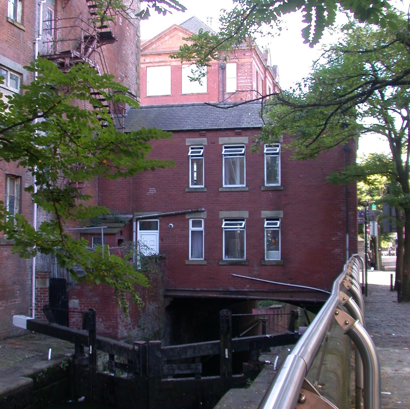
The house in 2016

It is the one that stands on Chorlton Street and straddles the Rochdale Canal.

I always assumed it had once been the home of the lockkeeper, and alternated between thoughts of how cool it would be to live there, with the obvious ones of living directly over a stretch of water on a very busy city street.

Back in the early 1970s it seemed to be unoccupied and as the years went by I had less reason to go down that part of Chorlton Street and just forgot about the place.*

But now I see it appears to be occupied again, and after someone recently asked me about it, the fascination has returned, and with it a mystery.

It does not appear on street directories for the 19th or early 20th centuries, and in 1851 is clearly shown as two buildings, one of which is a warehouse and a place of business and the other residential.

The warehouse and house, 1851

That said a Mr. John Holroyd is listed in the Rate Books for 1863 occupying 41 and 43 Chorlton Street in a property owned by the Rochdale Canal Company.  

All of which was confirmed by a street directory for the same year which describes him as “Lock keeper”.

And as every researcher knows once you have a reference in the historical records, it all comes together.

So, the same Rate Books record the property belonging to the Rochdale Canal from 1847 through into the late 19th century but the census returns stubbornly refuse to record who lived in 41 and 43.

Just occasionally there is a break through and from 1871 through to 1895 and I know that Barton Manchester and his family were there.  

A decade earlier he had been working the canal boats as an assistant, and on the night of the census was with William Wignall and Mr. Wignall’s family on a 50 ton “flat” boat moored on the Dukes Canal.

The house, 1955

He married Elizabeth Baron in 1867 and four years later they were settled in the house over the water.  He described himself as as a waterman.  Ten years later is listed as a “Lock keeper” and he and Elizabeth had a young family with the eldest of the four children aged 7 down and the youngest just 1.

And there the family stay, until his death in 1895.  Elizabeth had died in 1890 and both are buried in Philips Park.** He left £502 and a family that were launched on careers which took them away from the waterways.  The eldest was a clerk to a solicitor, and by 1911 was a “Railway Traffic Regulator", while the others were in various skilled occupations.

In time I will search out their lives, but for now I wll close with what little more I know of Mr. Manchester.  I doubt we will find a reference to his birth or any earlier historical records before 1861.

I know that when he married Elizabeth he was illiterate, giving his mark beside the signature of his wife.  

But there is a clue to that earlier life, and that comes from his first name, which is replicated by another “waterman” who in 1861 was plying another canal, working a boat with his father and family.  He too was called Barton, and I wonder if there is any connection with the aqueduct that carried the Duke’s Canal over the river Irwell at Barton -Upon-Irwell.

The house and canal, 2016

Fanciful perhaps, but possible.

Leaving me just book time to explore the lives of Thomas and Mary Holroyd, Willam Diamond, and Alexander Heap all of whom at some point resided in that house over the canal on Chorlton Street.

To which I can now add this from Hayley Flynn, "I thought you might like some info I found on the house on Chorlton Street over the canal. 

I'm writing a little bit about it at the moment and noticed you'd also been curious over the years - love the occupants you tracked down - Barton Manchester! 

This is the recent update I've written in my article: 

It seems that the Canals and Rivers Trust were the owners of the house until it was sold to an individual, Michael Maybin, in the early 2000s. Maybin continued to live in his flat in Hulme, presumably renting the property out. He died in 2019, evidenced by a police appeal to locate his next of kin; since then the house has remained occupied.

When you look on google maps it's after 2019 that the front of the house has physical changes too, which I guess would signal new occupants but I've not found any new documents relating to the owners so maybe it's still part of his estate".

Location, Manchester

Pictures; 41 Chorlton Street, 2016, from the collection of Andrew Simpson,  British Waterways narrow boats, proceeding to Hassall's Warehouse, Ducie Street, leaving Chorlton Street Lock, 1955, m54248, courtesy of Manchester Libraries, Information and Archives, Manchester City Council, http://images.manchester.gov.uk/index.php?session=pass and 41 &43 Chorlton Street, 1851 from Adshead’s map of Manchester 1851 courtesy of Digital Archives Association, http://digitalarchives.co.uk/


*Little David Street, https://chorltonhistory.blogspot.com/2016/10/lost-and-forgotten-streets-of_14.html

**Philips Park Cemetery, Plot FNon Conformist 426 


In the King's Arms in Eltham with William Goodwin sometime after 1822

“A characteristic feature of the King’s Arms is the quant fire place which still exists in the parlour, as well as the ancient clock, the old bacon rack, and the distinct air of antiquity which all the rooms wear, and it is easy to imagine the association of the house with times earlier than the middle of the 17th century, the date mentioned in the book of taverns.”*

Now when R.R.C, Gregory wrote this description of the place in 1909 it may well already have clocked its second century.

For there is a tantalizing reference to an inn at Eltham from a directory of taverns in the counties around London, but sadly we do not have a name.  Mr Gregory rather thought it might have been the Castle on the strength of the date of two metal tokens found on the site which carried the legend, THE CASTELL. TAVERNE – A Castle, and  ELTHAM. 1649 – N.T.M.

Tokens circulated widely in the 17th and early 18th century and were a direct response to the lack of low denomination currency which led to businessmen and traders creating large issues which could be redeemed at the shop, warehouse or inn of the owner.

And along with the 1649 token were ones from other merchants dating back slightly earlier and in to the 1660s.

All of which lies wide open the question of which was the oldest pub and for that I guess I will have to wait.

But at least I know that the Kings Arms was in the hands of William Godwin by at least 1822, for in that year he and his wife Ann baptized their son in the parish church and there in the records he is listed as an inn keeper.

And we can then track him through tax records, local directories and the census all the way up to 1871, by which time he was 80 and living with his two sons, a married daughter a grandson and two lodgers.

Across the way behind him at the Crown was John Martin who had started his pub career just a little later but was also still going strong in the April of 1871.

Now I like the etail in these pictures so I was drawn to the Dartford Brewery sign which dates our photograoh from sometimetime between 1897 and 1909.

According to AIM25, 'the Dartford Brewery was founded as "Miller and Aldworth", and from 1887 "Miller and Aldworth Limited". 

It was incorporated in July 1897 as "Dartford Brewery Company Limited". The Brewery was situated at Lowfield Street, Dartford, Kent.

The brewery was acquired jointly by Style and Winch Limited and the Royal Brewery Brentford Limited in 1924; and was therefore acquired by Barclay Perkins and Company Limited in 1929 when it purchased Style and Winch Limited and the Royal Brewery Brentford Limited.

The Brewery went into voluntary liquidation in 1970'.**

*R.R.C.Gregory, the Story of Royal Eltham, 1909

**Aim25, AIM25 is a major project to provide electronic access to collection level descriptions of the archives of over one hundred higher education institutions, learned societies, cultural organisations and livery companies within the greater London area http://www.aim25.ac.uk/


Pictures; The Kings Arms and the old fireplace from The story of Royal Eltham, R.R.C. Gregory, 1909 and published on The story of Royal Eltham, by Roy Ayers, http://gregory.elthamhistory.org.uk/


Jack Beasley ……… his collection of Chorlton pictures ……. and a story … part 1

This is Chequers Road, sometime in the 1940s.

Chequers Road/Church Road circa 1940s
Of course, back then it was Church Road, and it is one of a remarkable collection of family snaps belonging to Kirsty.

Her family have lived in Chorlton for over 80 years and many of the photographs are of this one road

Her dad lived at number 41, and as they say the cross in the picture marks the spot.

Walk along the road today and the scene is pretty much the same, barring the inevitable number of cars and the lack of net curtains which were still a badge of respectability.

Outside 39 Church Road, with the "criss cross brown paper", circa 1939-45

Now if I wanted to hazard a guess, I think our picture will predate 1939, or certainly have been taken after 1945.

And the clue is in the absence of “the criss cross brown paper anti blast tape at the windows”, which Jack Beasley refers to on another of the pictures which was taken in the garden of 39 Church Road during the last world war.

The group consist of “Gerald Booth left, Jack Beasley, right, Gerald Vodon, [below] left, and Phyllis Vodon, [below] right”.

 Flo Beasley, date unknown
I know Kirsty has done some family research and the stories of the four will feature later, but for now I am intrigued by the unknown woman posing with a bunch of flowers.

I think she will be in the front garden of number 43, because comparing the image with others the front gate behind her is a match for number 41.*

And a trawl of the 1939 Register shows a Mrs Pauline Donbavand listed as living there along with her husband and Walter Meadows who was a Police Constable.

Pauline gave her occupation as a “Theatre Usherette”, had been born in 1909 and was two years younger than her husband.  

There is a slight confusion of the spelling of her surname which is a little unclear from the official record and Police Constable Meadows is listed as married but his wife is missing.

But like census returns, the 1939 Register was conducted on one night in early September and Mrs Meadows may have been elsewhere.

Added to which our unknown lady may not be Mrs Donbavand.  

According to Kirsty  she  could actually be  "my grandmother Flo Beasley", and certainly looking at family photographs there is a resemblance between the lady with the flowers and her grandmother.

So I rather think that is our mystery woman.

Outside 41/43 Church Road, date unknown
Equally intriguing is the way that some entries are redacted, so while Florence, Lilian and George Beasley appear, another two are hidden from view. 

That said I know that Florence was a “Bedding Machinist”, Lillian a “Shorthand typist” and George a "sapper" in the “Royal Engineers”, added to which an official returned to the list and changed Lillian’s status from single to married and including her new surname of Symonds.

There was nothing odd in the official alterations, as the 1939 Register was a working document and was used both for compiling the war time Identity cards, and for the new National Health Service which came into being in 1948.

Leaving me just to reflect that 83 years ago the occupations of those on Church Road, included two “house painters and paper hangers” a “retired Foreman lamp lighter”, an “Electrical engineer” along with a "chimney sweep", "a salesman", and a lorry driver.  With these were the familiar “unpaid domestic duties” and with a nod to the war, an “Auxiliary Fireman based at No.158 Manchester", and a number of servicemen.

I wonder what a contemporary tally of occupations would reveal.

Location; Chequers Road/Church Road, Chorlton

Pictures; Church Road circa 1939-45, from the collection of Kirsty

*There is however one hiccup and that is the modern street numbers for 41 and 43, do not correspond to what I think was the case in 1939 which may mean there was a change of numbers after 1939 ..... or I have just got it wrong.


When Manchester embraced Mr. Shakespeare …….

It might seem a daft title, but it perfectly sums up the story of how William Shakespeare came to mean so much to Manchester over the last two centuries.

Mr Shakespeare's window
And for those who aren’t fully aware of the connection between the city and the playwright, there is an excellent exhibition at the Central Reference Library which offers up the story.

It runs until May 30th and in the words of Ian Nickson who collated the exhibition it is “the story of how seven personalities transformed Manchester into a global centre of Shakespearean theatre in the Victorian era and reveals present-day evidence of the city’s innovative engagement with the works of Shakespeare.

These seven people operated in diverse fields - business, religion, theatre, architecture, academia, politics - but were united by their appreciation of Shakespeare’s cultural value and, as if imitating the seven bees atop Manchester’s coat of arms, they collaborated to create an urban, libertarian, distinctively Mancunian interpretation of Shakespeare’s works”

They include “local businessman John Knowles who commissioned the Theatre Royal on Peter Street in 1845 and installed a marble statue of Shakespeare above the main entrance, early evidence of a desire to link Manchester with high culture

The actor-manager Charles Calvert who produced spectacular, historically accurate and commercially successful revivals of Shakespeare’s plays which, by appealing to all sections of society, developed into a ‘one-nation Shakespeare’ with global appeal.

Mr. Shakespeare and the Theatre Royal, 2024
In 1875, Calvert’s revival of Henry the Fifth was exported to the United States, prompting two New York impresarios to organise the fastest crossing of the continent by train as a publicity stunt and launching the career of the first global Shakespearean celebrity, George Rignold".

To these can be added Henry Irving who in 1860 came to Manchester and resurrected his career. He had who arrived as a failing actor, and his time in Manchester set him on the road to becoming the Victorian era’s most celebrated tragedian.

But that is where I shall stop because where would the fun be in just reading about the exhibition when you can come along and enjoy if for yourself and discover the other four notable people who in their own different ways brought the Bard to the city and whose influence is still here to uncover?

For more details please contact:

r. Ian Nickson. Honorary Research Fellow, University of Manchester, ian.nickson-2@manchester.ac.uk

Kattie Kincaid, Project Lead for the Shakespearean Garden,  kattiekincaid@hotmail.com

Location; Manchester Central Library, St Peter's Square, Manchester, M2 5PD

Pictures; the Shakespeare Window, 2025, courtesy of Ian Nickson, and Mr. Shakespeare at the Theatre Royal, 2024, from the collection of Andrew Simpson 


Friday, 3 April 2026

When the Rec had a bowling green ………..

Now, I don’t remember the bowling green on the Rec, by Beech Road, but lots of people over the years have talked about it.

I have always thought it was on the south side of the Rec, close to Wilton Road, but not so.

It occupied a space in the north west corner, and this I know because I am looking at the OS map for Beech Road, dated 1956.

I know the bowling green was not in the original plan for the Recreational Ground and had disappeared by the 1970s.

Just when it was deemed no longer a recreational asset will be down to people’s memories and a trawl of subsequent maps.

And back then there was that other bowling green beside Cross Road, it became the car park for the Irish Club.

All of which leaves me to wait for comments of those who remember the bowling green on the Rec and when it disappeared.

Location; Chorlton

Picture; detail from the OS map for south Chorlton, 1956, "Courtesy of Manchester Archives+ Town Hall Photographers' Collection", https://www.flickr.com/photos/manchesterarchiveplus/albums/72157684413651581?fbclid=IwAR0t6qAJ0-XOmfUDDqk9DJlgkcNbMlxN38CZUlHeYY4Uc45EsSMmy9C1YCk 

Walking the streets of Manchester in 1870 ................ part 4 ... calling on Mr and Mrs Hall at no.35 Wood Street

Now I am standing outside numbers 33 and 35 Wood Street in 1903.

33 and 35 Wood Street, 1903
In time I will search out who had been living in the two properties although by the time Mr Bradburn took his picture on March 20th 1903 they were unoccupied and in a pretty poor state.

That said I suspect they had never been prime examples of good housing.

In 1870 when we were walking the streets of Manchester they backed onto Paul’s Court, which consisted of eight back to back properties facing onto a narrow open space.

Originally our two houses had been made up of just three rooms but at some point in the 19th century they were extended, by the simple process of knocking through into the two homes they backed  onto.

Without more research I can’t be sure when this was but I do know that in 1871 number 35 was occupied by Mr and Mrs Hall who had moved in the year before and were still there twelve years later.

He was a general labourer aged 46 and had been born in Manchester.  His wife Ann was three years younger and was from Ireland.  They had two children, but the youngest, Jane carries a different surname and there in no clue as to the relationship with Mr and Mrs Hall.*

Wood Street, circa 1900
The rate books show that when they moved in they were paying 2shillings and sixpence which a decade later had risen to 3 shillings.

And back in 1871 number 35 was unoccupied.

Their immediate neighbours made a living from a mix of skilled, semi skilled and manual work.

Three doors down at number 29 Mr Leslie was a shoemaker, while his wife was a seamstress, and there was a brass moulder, butcher, poulterer, two charwomen and a cotton weaver close by.

33 and 35 Wood Street, circa 1900
Now we can actually pinpoint numbers 33 and 35 on Wood Street, for while they have long ago vanished, maps of the period place them directly opposite the Wood Street Mission.

Today the site is a small car park for the Rylands Library and just down from that space is a passageway which may have been the entrance to another court called Bradley’s Yard.

I like the idea of being able to walk along Wood Street and stand in front of what had been a house I have come to know.

Of course the challenge is now to peel back more of its past and in so doing reveal a little of its residents and
owners.

We know the names of some of the other occupants, and also that for two decades it was owned by the Taylor family.

Back of 33 and 35, once Paul's Court, 1900
But there will always be much that we will never know, and I suspect the young Jane Thompson will be one of those lost stories.

Still a trip down Wood Street is well worth it.

The Mission Hall which the Hall family would have seen every day is still there and is well worth a picture.

After that there is always the Rylands Library or a quick walk down that passage sandwiched between the back of the library and the side of the Magistrates Court and on to a small open square.

Location, Deansgate, Manchester

Pictures; Wood Street, 2007, from the collection of Andrew Simpson, numbers 33 &35, m05389, backs of numbers 33 & 35 m05391, A Bradburn courtesy of Manchester Libraries, Information and Archives, Manchester City Council, http://images.manchester.gov.uk/index.php?session=pass  and Wood Street, circa 1900, from Goad's Fire Insurance Maps, Digital Archives Association, http://digitalarchives.co.uk/

Wood Street, 2017


*Wood Street, 1871 census, Enu 2 11, Deansgate, St Mary’s Manchester, 1871

Visitation of God or manslaughter, the death of John Bradshaw in Eltham in 1837

Rural communities have never been the peaceful idyllic places some would have us believe.

In just a short two decades, the small township of Chorlton-cum-Hardy experienced two murders, a series of daring burglaries and two cases of infanticide.

There were also groups of violent drunks from Manchester who persistently intimidated the local residents and just a mile or so away passengers on packet boats travelling along the Duke’s Canal from Stretford were pelted with stones.

Some of the crimes were opportunistic, others like the poaching of potatoes from the fields on the northern side of Chorlton were organised by gangs who came in from Hulme equipped with wheel barrows and their own sacks.

From the Times February 1 1837
And then because the southern end of the township opened out onto the flood plain and was relatively remote it was perfect for illegal prize fighting which could attract hundreds who if necessary could escape over the Mersey into Cheshire and thereby evade the Lancashire police.

All of which makes me think that the drunken attack on the landlord of the Castle in Eltham High Street in the January of 1837 will not have been an isolated case.  Indeed just a few months later an armed gang of escaped convicts from Woolwich were apprehended trying to make for the woods to the south of Shooters Hill.*

Now there is a danger in elevating two events into a crime wave, but I rather think it is just that we haven’t looked too closely at the newspaper reports or the Quarterly Sessions.

And so back to Mr John Bradshaw, late of the Castle in the High Street and the story of John Foster who came to the assistance of the landlord.

Like so many nice tales of the past its telling emerged from a chance discovery of a newspaper report of the inquest into Mr Bradshaw’s death and the work of my new chum Jean who is a descendant of John Foster.**

The Foster’s ran the smithy in the High Street and were well respected that stories of old Mr Foster were still circulating into the town almost a hundred years after he first arrived from Carlisle.

The Castle in 1909
The story itself is not an unusual one, a drunk by the name of Lucas fell foul of the landlord who ordered him out and in the subsequent scuffle Mr Bradshaw was hit and fell over.

And this was where the young John Foster came into the story attempting to remove Lucas from the pub not once but twice.

In the meantime Mr Bradshaw had died and the medial opinion was his death had been “caused by a sudden fit or a convulsion of the brain, produced by a fall.  His death must have been instantaneous.”***

The inquest was held in Mr Bradshaw’s pub which was a common enough practice, given that after the church the only other public place large enough would have been the school house or a pub.

Now I have come across quite a few inquests from the period and what I always find fascinating is that they provide a rare opportunity to hear ordinary people, many of whom have not left a scrap of written material about themselves or their times.

And so here we have John Foster, along with John Heritage and Mrs Bradshaw speaking directly to us of the event that happened that night.

Nor is that all for in the course of the inquest other people are mentioned all of whom it should be possible to track down.

But most striking is the clash between the coroner and the Jury.  He was satisfied and said so that the death was “by the visitation of God” rather than at the hand of Lucas which conflicted with their verdict “That the death of the deceased was caused by over excitement, produced by the conduct of James Lucas.”

Remarkably the Coroner refused to accept the verdict, directed them to think again and when by a majority they returned the same decision commented “I cannot agree with you that your verdict is a proper one. [and was] bound to order you all to appear at the Criminal Court and take the onion of the learned judge whether I am bound to receive such a verdict, which is in direct opposition to the evidence.”

This is a judgement by the Coroner made all the more odd given one witness reported that it was Lucas’s blow to Mr Bradshaw which had resulted in the fall and subsequent conclusion commented on by the surgeon.

Now unlike other inquests I have written about we do not know who the jurors were and that is a pity because they appear to have been a resolute bunch prepared to stand up to the Coroner.

So much so that the foreman was moved to comment that “If we are obliged to attend without returning our verdict, I am quite at a loss to know what use it is to call jury.  For my part I have come to the determination to return no other verdict.”

All of which makes me feel for these “little men” who were prepared to stand their ground against the professional with all his authority.

Now that could just be the end of the story but not quite.  John Bradshaw was buried in the parish church and there will opportunities to pursue the lives of the others mentioned in the inquest.

And so to Lucas.

From the court records, 1837
A search of the criminal records revealed that a James Lucas aged 51 went before the Kent Assizes on January 30th 1837 for manslaughter and was acquitted.

There is of course a slight mismatch in dates.  The inquest report is dated February 1st and the hearing was the day before.  But given that the Times reported that the inquiry was adjourned until the following evening when the Coroner had consulted a higher authority “as to whether I can receive your verdict” it may well be that the jury was once again ignored.

As it was James Lucas was in Well Hall in 1841, a widow living with his two daughters, Harriet aged 14 and Emmie aged 12.  His given occupation was a sawyer and so now a new search begins, for information on his wife Sarah and perhaps some of the other people named in the inquest who may well have worked with him.

*Convict Chase and Capture, the Times May 8th 1837
**Tragedy at the Castle Inn, Jean Gammons and based on a report in The Times February 1st 1837
***evidence of Mr David King, surgeon

Picture; The Castle Inn from The story of Royal Eltham, R.R.C. Gregory, 1909 and published on The story of Royal Eltham, http://www.gregory.elthamhistory.org.uk/ 

Thursday, 2 April 2026

In the midst of plenty ........ two children sleeping rough “one under a Salford Railway arch and the other below an old staircase in a Deansgate entry”

It still beggars belief that in a city some called the “second city of the Empire,” which proudly displayed its trade links to the world in its brand new Town Hall and would ambitiously build its own route to the sea children slept rough on the streets,  making a pitiful living selling matches, and shoe laces later in to the night.

First Shelter, Quay Street, 1870
But of course it happened and in response to the stories of children sleeping under a Salford Railway arch and another below an old staircase in a Deansgate entry, the Night Refuge for Homeless Boys opened its doors.

Its full title was “The Boys’ Refuge and Industrial Brigade” and on January 4 1870 if offered a handful of boys found on the streets of the twin cities, a bed and breakfast, before turning them out on to the streets again.

Within a decade the organisers had expanded into a  ranges of activities designed to help young people and a full half century later could point to a whole series of achievements, from rescuing children  off the streets to residential and vocational homes,  seaside holidays, and involvement both in the courts and in legislation to protect young people.

Along the way it also migrated some young people to Canada.

But it began with that one building.

It was on Quay Street off Deansgate and a quarter of century later Mr Shaw one of the prime movers in the shelter reflected on those early days.

“In a dark little room on the ground floor of the house was a living room where meals were served.  A front collar was a living-room by day and a school and band room at night.  The back cellar, described as being dark and damp as a cavern, was made to serve the purpose of a bathroom and lavatory .  

The sleeping accommodation was almost amusingly primitive. 


It took the shape of hammocks hung out round the upper room from strong hooks in the wall, each hammock having two iron legs which fitted into sockets in the floor.    [and] when the boys jumped into bed ‘with a burst’ away went the held fasts and sockets and even a portion of the wall too, and that a dusty heap in the middle of the floor was generally the rest.

Mr Shaw and a group of Boys, 1883
In the year 1870 there were some forty inmates of the Refuge.  Today nearly 500 boys and girls are being cared for and trained within the institution to a life of usefulness, while according to the last report issued in 1894 , not less than 2,595 children come more or less under the influence of the Society and its branches in the course of 12 months.”*

Those involved were motivated by strong religious convictions, but also by that simple and obvious response that not only was the plight of destitute and neglected children and an abomination but “while we leave the little children practically uncared for we shall never want for a fully supply of candidates for our reformatories, workhouses and goals.”

The building had a short life and the organisation relocated to Strangeways but the scale of the problem was such that one refuge was not enough.

That lack of provision was highlighted “in the winter months of 1871 when three boys applied at the Refuge looking for shelter.

Major Street Shelter, 1905
As the home was already full, they had to be turned away. Seeking warmth and shelter and being unable to afford three pence to stay in a lodging house for the night they had wandered up to the brickfields of Cheetham.

A few days later a newspaper reported on the demise of a young boy who had been burned to death at one of the brick kilns in the neighbourhood. This boy was one of the three who had, had to be turned away much to the consternation of the committee.

It was this incident that convinced the charity that they needed another building in which to receive any child in need of help, whatever the hour and this led to the opening of another on Major Street.

"Open all day and all night children in need of shelter could be brought and receive food and a bed for the night, whilst their individual circumstances were investigated. It ensured that no child requesting aid would ever be turned away again.”


Location; Manchester & Salford

Pictures; the first refuge opened in 1870 and a group of young boys from the charity in 1883, and the Major Street Shelter 1905 courtesy of the Together Trust, https://www.togethertrust.org.uk/

* The Boys’ and Girls’ Refuges A quarter of a century’s progress, Manchester Guardian, January 4 1895

**A new book on the Together Trust, https://chorltonhistory.blogspot.co.uk/search/label/A%20new%20book%20on%20the%20Together%20Trust

One big House on the High Street

2015
Now I have written about Cliefden House on several occasions, and will go back again in due course.

In the meantime here are three photographs over a full century and a bit and each has it’s own story to tell.

The first was taken recentlt by Ryan and despite the changes of businesses it is not so different from Jean Gammon’s taken 38 years earlier.

1977
Step back another 60 years to 1909 and the transformation is pretty stunning.

Back then it was a private residence and in the middle of the 19th century had been a military academy.

It was built sometime around 1720 with an eastern addition dating from the mid 19th century and together this made for a large 17 roomed house.

In the 20th century the front garden and wall were lost when the High Street was widened and more recently with scant disregard for such an elegant old property businesses have set about about adding the most appalling signage to the exterior.

1909


Pictures; Cliefden House, 2015 courtesy of Ryan Ginn, back in 1977 from the collection of Jean Gammons, and in 1909, from The story of Royal Eltham, R.R.C. Gregory, 1909 and published on The story of Royal Eltham, by Roy Ayers,http://www.gregory.elthamhistory.org.uk/bookpages/i001.htm 

The Lost Chorlton pictures ......... no 9. ......... Beech Road

Now I had quite forgotten this picture, which had sat as a negative in the cellar for four decades.

And I am rather pleased it has come to light.

We are on Acres Road and to our right is the box factory which had once been a laundry, and opposite is the hair dressers which was to become Cafe on the Green.

Directly ahead is the pet shop which closed earlier in 2019, and beside it The Village Wholefood Shop.

Back then there was a debate about that bit of open land, with some of the traders urging the Corporation to make it into a car park which the Council agreed to if the traders made a contribution to the cost.

This never happened and what had once been a fine house before it was demolished remain open land for another decade.

Location; Chorlton

Picture; Beech Road, 1979 from the collection of Andrew Simpson

Wednesday, 1 April 2026

Walking the streets of Manchester in 1870 ......... part 3 ........testing the story of dark secrets and awful tragedies in Wood Street

Now it is very easy to fall into the trap of using newspaper reports to draw a picture of the past.

And so far that is what I have done in the new series on walking the streets of Manchester in 1870.

As everyone knows, just yards from the broad and affluent main thoroughfares of the city, was another world where unless you were very poor you dared not venture.

Wood Street was one of those.

It was and is a narrow street off Deansgate and is best known for the Wood Street Mission which sought to provide basic support for the very poor.

The charity was established in 1869 and is still going today.

Its activities included running a soup kitchen, a rescue society and home for neglected boys, and a night shelter for the homeless.  It handed over thousands of clogs and items of clothing each year, as well as hundreds of toys at Christmas.

Around the Mission poverty not only busied its self but was pretty much what defined the street, and those newspaper reports dug deep into the squalor and human misery.

There were five articles published by the Manchester Guardian from February to March 1870 and they ranged over the back streets of Deansgate, across to Angel Meadow and up Market Street and down to London Road.**

The descriptions of awful living conditions, drunkenness and prostitution are as shocking to day as they were nearly 150 years ago.

And the reports are essential reading for those wanting to know more about living conditions amongst the very poor and in particular as a backdrop to the growing movement to care for the legion of abandoned, destitute and abused children.

But nothing should be taken at face value, which meant trawling the records to test how far the vivid descriptions matched reality.

The starting point as ever were the street directories which list householders and with names you can search the census returns to find the families which in turn will offer up information on occupations, the numbers of people living in each house and the density of housing.

Wood Street, 1849
And that data can be matched with maps of the area, making it possible to follow our journalist along Wood Street.

Not that it is that simple, because in 1870 the entire residents of Wood Street were not worthy of inclusion in the street directory which meant looking instead for the nearest properties on Deansgate, and using the name of the householder to visit the census return for the area.

43-49 Wood Street, 1903
Happily it paid off and just over half of the twenty pages of the particular census return were for Wood Street.  In total there were 276 people living in forty four properties, many of which were in closed courts off Wood Street and accessed by dark narrow passages.***

Some of the courts had names like Smith’s Court, Bradley Court and Pilkington’s while others didn’t even rate a name.

Most of the properties were back to back and consisted of just two rooms and will have been in various states of repair.

And at random I fastened on the Ellis family who lived at number 3 Robinson’s Court which was at the western end of Wood Street hard by a Hide and Skin Yard.

The court was accessed through one of those narrow passages off Wood Street and in turn led off to another and unnamed court.

Robinson's Court, 1849
Robinson’s Court would have been dark, admitting little sunshine or fresh air and its occupants would have had daily to cope with the smell of the Hide and Skin Yard, just yards away.

Mr Thomas Ellis was a stone mason’s labourer, aged 33 from Manchester.

His wife Mary had been born in Dublin and was a silk winder.

Together with their four children they occupied the two rooms which made up number 3.

No photographs exist of their home but by exploring the rate books we know that they paid one shilling a week and that their landlord was John Highams who owned all six properties in the court.

33 & 35  Wood Street, 1903
A further search of the rate books will reveal the extent of Mr Higham’s property portfolio and by finding out just how much Mr Ellis earned it should be possible to judge how significant that shilling was to the family budget.

What is interesting about Wood Street is the number of lodging houses which according to the article were at the bottom end of the market with overcrowding being the norm and some verging on “vice shops.”****

I think it may be impossible now to ascertain how accurate was the journalist’s observation of “drunken women standing about the doorway, or coming in with some drunken man whom the gin shops of Deansgate have half maddened.”****

But I suspect the discovery of a group of women in another house is all too true.  “On the knees of the centre figure of this strange group lies a little month-old baby, dying-the last of twins.  It is miserably thin and the yellow skin shows the articulation of its frame.... the eyelids are drawn close down, and a long bony arm weakly and painfully raises itself.”****

One of the courts off Wood Street, 1903
We will never know the identity of any of the group or the final fate of the child, but a few days later the mother had taken refuge in the most debased of lodging houses.

Today Wood Street is still narrow, the Mission building is still there but as for the rest it has long ago vanished.

Location; Manchester, 1870


Pictures; Wood Street, 2007, from the collection of Andrew Simpson, numbers 43-49, 1904, m05386,numbers 33 &35, m05389, backs of numbers 33 & 35 m05391, A Bradburn courtesy of Manchester Libraries, Information and Archives, Manchester City Council, http://images.manchester.gov.uk/index.php?session=pass  and Wood Street, 1849, from Manchester & Salford OS, Digital Archives Association, http://digitalarchives.co.uk/

*Walking Manchester in 1870

**In the Slums, Manchester Guardian, March 3 1870

***Wood Street, from the 1871 census, Enu 2, 9-20, Deansgate, St Mary’s

****In the Slums, Manchester Guardian, March 3 1870


The Romans really were in Well Hall .... 1,900 years ago

The discovery of what could be the remains of a Roman hypocaust system has been uncovered in an archaeological dig in the back garden of a house in Well Hall.

Elena Verdi of the 'Istituto di antichità classica di Napoli, announced this morning that "the find is very significant and raises the possibility that this was part of a villa complex or even the bathhouse of a previously unknown Roman military establishment".

BREAKING NEWS

It can now be revealed in advance of the press conference to be held in Naples at the offices of the Istituto di antichità classica di Napoli at midday, that the remains discovered in the garden of a Well Hall house are not Roman.

A saddened Elena Verdi, will announce that her team were a little hasty in their conclusions.  "I think we were all too excited by a metal box inscribed with an advert in Latin for 'Mario's take away fish paste', and in retrospect concede the remains appear to be an early 20th century  black pudding mine, which were known to be extensive in the Well Hall area at the time."

It is also believed she has withdrawn the souvenir plastic models of Roman soldiers carrying the inscription. "Visit Well Hall and take a break from all that conquering" which were found at the dig site.

Location; Well Hall

Picture; the remains, 2019 courtesy, Istituto di antichità classica di Napoli