Castlefield is the area off Liverpool Road and the name derives from the Roman fort, which was situated where the Rivers Medlock and Irwell joined.
It runs from Deansgate down to Water Street and across from the Castlefield Basin towards Quay Street.
Castlefield was first settled by the Romans who built a fort here. The fort was part of a network of forts, which linked the big legionary bases at Chester and York. Outside the fort grew up a typical small town. These towns were not the familiar carefully planned towns of history books, but just small time urban sprawl supplying the needs of the military. Such settlements can be found in many of the frontier areas of the Empire, and similar remains have been excavated beside the big forts along Hadrian’s Wall.
They were rough, tough places, more like the small townships of the American West in the mid 19th century. The archaeological excavations of the 1970s showed that Manchester was a thriving and busy place. The main road out of the fort had been resurfaced a number of times and there was evidence of wooden buildings and an iron works. Nothing now remains of the dig but the small residential complex by Tonman Street and Lower Byrom Street rests on the site of the dig.
During the Middle Ages the centre of Manchester shifted to the Cathedral area and by the 13th century Castlefield had become a Deer park.
Today it is just possible to see the geography of the area. Standing at the top of Liverpool Road you can see that there is a gentle slope down to Water Street, and the river Irwell.
Fields Rivers and canals
Castlefield began to develop during the 18th century. By the mid century the river Irwell had been developed to allow ships from Liverpool to dock in Manchester and by the early 19th century the Bridgewater and Rochdale Canals terminated at the Castlefield Basin. This meant that Manchester was connected by water to the rest of the country. It is still possible to use the canal network to link up to the Cheshire Ring, and by following the Rochdale Canal through the heart of the city reach the Dale Street Basin at Piccadilly and link with the Ashton Canal.
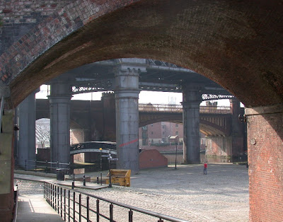
Much still remains of the canal legacy. The canal basin still provides mooring places for barges and by Dukes 92 you can get a view of working lock gates. There are two restored warehouses near Dukes. The Merchants Warehouse opposite Dukes was built around 1823 and originally was used to store cotton. The Middle Warehouse was converted in the 1990s. Dukes was a stables, which served the Merchants Warehouse. While the Oxnoble Hotel on Liverpool Road is a reminder that potatoes were landed from Norfolk at Potato Wharf.
Along the river there developed dye works. One such works belonged to John Rothewell who built a home at the corner of Liverpool Road and Water Street in the early years of the 19th century. His home was to become the stationmaster’s house when the Liverpool Road Railway Station was built, and is still there today. By the 1820s the area was a mix of warehouses dye works timber yards and offices. There after the area retains this mixed industrial character and it’s possible to see little change from the maps of the mid century to those of the close of the 19th century. The only exception being the increased number of railway viaducts, which were erected after 1850.
Location; Castlefield
Pictures; Castlefied Canal Basin from the collection of Andrew Simpson, unearthing Roman Manchester from the Deansgate Dig, photograph by D.Wildgoose, 1972, m07315, courtesy of Manchester Libraries, Information and Archives, Manchester City Council, http://images.manchester.gov.uk/index.php?session=pass


No comments:
Post a Comment