I am looking at one of my favourite maps of Chorlton-cum-Hardy.

It was produced for the Withington Local Board of Health in 1881, and I have Ricard Bond to thank for copying this section.
The Withington Local Board of Health was established following the Public Health Act of 1876, and covered the four townships of Burnage, Chorlton, Didsbury and Withington, and along with building the sewage works commissioned the map.
It is a beautifully detailed map and I have chosen the section which covers the area to the west of what is now the library stretching almost as far as the Longford Estate.
There is much to take in including the 27 properties that made up Fielden Terrace which was a community in itself, along with the Longford Brook, the Canal Feeder and the set of ponds some of which will have been the result of excavating marl and clay, a practice which went back to the 17th century.
These I have written about over the years and came back to recently.*

What I had never noticed before was the footbridge across the Longford Brook, which I guess vanished when this stretch went underground, leaving just a small section through Longford Park open to the sky. There are those who can remember when it was still there to see. Equally another short bit in front of Copley Road was still exposed as late as 1934.
Just when most of it went underground is as yet unclear. It was there in 1907 but had vanished by 1933.
And that is it.
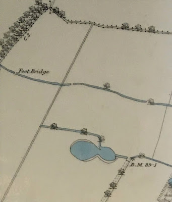 |
"Although I copied the map, I also did not notice the footbridge until much later. As you say, this is a bridge over Longford Brook, not the canal feeder - the canal feeder is the watercourse running parallel to the Longford Brook, a little to the south, so OS have mis-labelled it. The section with the footbridge was culverted by the time OS surveyed a new map in 1892, see https://maps.nls.uk/view/126523724#zoom=5&lat=7759&lon=9124&layers=BT
Note that the trees shown at top left are roughly where the present tree line of the eastern boundary of the disc golf course is located. The trees marked the then eastern boundary of the Longford estate but between 1876 and 1881, John Rylands and the Lloyd family exchanged lands, the result being the artificially straight boundary line running roughly N-S, to the east of the foot bridge. By 1892, Enriqueta Rylands had planted the present line of poplars, next to the boundary with Ryebank Fields, to mark the new boundary of her estate".
Location; Longford Road
Pictures; west of Martledge close to the Longford Estate, 1881 from the Withington Local Board of Health map, 1881,courtesy of Trafford Local Studies, and copied by Richard Bond
*Of clay pits ...... meandering streams …….. and plenty of ponds …… walking west of Martledge in 1854, https://chorltonhistory.blogspot.com/2021/11/of-clay-pits-meandering-streams-and.html
Although I copied the map, I also did not notice the footbridge until much later. As you say, this is a bridge over Longford Brook, not the canal feeder - the canal feeder is the watercourse running parallel to the Longford Brook, a little to the south, so OS have mis-labelled it.
ReplyDeleteThe section with the footbridge was culverted by the time OS surveyed a new map in 1892, see https://maps.nls.uk/view/126523724#zoom=5&lat=7759&lon=9124&layers=BT
Note that the trees shown at top left are roughly where the present tree line of the eastern boundary of the disc golf course is located. The trees marked the then eastern boundary of the Longford estate but between 1876 and 1881, John Rylands and the Lloyd family exchanged lands, the result being the artificially straight boundary line running roughly N-S, to the east of the foot bridge. By 1892, Enriqueta Rylands had planted the present line of poplars, next to the boundary with Ryebank Fields, to mark the new boundary of her estate.
Thank you Richard
ReplyDeleteWas the canal feeder also culverted or just filled in once it was no longer needed?
ReplyDeleteIt was culverted although a bit in Longford Park was still open to the sky until recently.
Delete