Thursday 3 October 2024

The secrets of Turn Moss and the Isles …….. marl pits and water filled ponds

Now, we have lost most of the features of our rural past, here in Chorlton.

The Old Road, 2016
But just occasionally there are still a few hints of that past.

Of these there is the Old Road which stretches out from Chorlton across Turn Moss and on to Stretford.

I call it the Old Road, but most people will know it as Hawthorn Lane, although on official documents from the mid-19th century it was called Back Lane, while parts of it were also referred to as the Cut hole Lane and Town’s Bank.

It is somewhere I have written about in the past and keep coming back to.*

Once it will have been used by farmers transporting produce to the Duke’s Canal and the raised roadway underneath the canal’s aqueduct, bears witness to the need to protect pedestrians from passing wagons.

Even now, if you walk the route there is a sense that you are walking a country lane, with the overhanding trees, the remnants of hawthorn fences and the twisty nature of the lane.

And it is filled with history, starting with the site of Sally’s Hole, a pond which dates to at least the 18th century was only filled in, sometime in the 1960s.

The Old Road, circa 1900
That said, the scene on either side bears little witness to what it would have one looked like.

The mass of trees, and bushes would have been absent and instead the area was very much open land with the od avenue of trees.

And had you walked the lane two centuries ago you might well have caught sight of the “marl men” engaged in extracting marl from pits which was used to spread on the land.

Marl which contains carbonate of lime was a cheap substitute for lime and spreading it on the land would enhance the land’s fertility for up to twelve years.

Writing in 1899, H T Crofton in his book on Stretford, drew on older authorities who recorded that “most of the old pitsheads yet extant in the fields have been quarries whence marl has been obtained.

In marling, the gaffer of the pit, who controlled the falls and excavations, was called ‘My Lord’.  Passersby were solicited to contribute to the marling or shutting, or feast, at the conclusion of their laborer’s”.


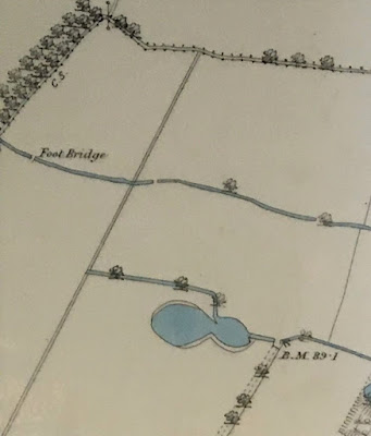
Marl Pits, 1853
These pits could be quite substantial and involved clearing the top soil and then "‘shooting the pace’ which involved “making a broad way of a very easie ascent and descent for the convenience of fetching out the marl”.**

The degree to which this was a lucrative business can be seen in one legal dispute concerning the extraction of marl during the 17th century and the large number of pits in the area around Oswald and Longford roads, which was known as the Isles due to the larger number of pits and lazy watercourses which stretched out across the land.

The 1853 OS map shows plenty of these, and according to H T Crofton the area around what was once Firs Farm was similarly dug.

Most filled with water, and in time must have been a source of concern for parents.

Next; Firs Farm

Pictures; The Old Road, 2014, from the collection of Andrew Simpson, the Old Road, circa 1900, from the Lloyd Collection and detail from the 1841 OS Map of Lancashire courtesy of Digital Archives, http://www.digitalarchives.co.uk/


*The Old Road, https://chorltonhistory.blogspot.com/search/label/The%20Old%20Road

**A History of the Ancient Chapel of Stretford H T Crofton, 1899

1883 .......... one year in the work of the Manchester and Salford Children’s charity

Now 1883 was a busy year for our own children’s charity which had been established just thirteen years earlier as a rescue mission to feed and give a bed for the night to destitute boys on the streets of Manchester and Salford.

Outside the Refuge offices, circa 1900
Just over a decade and a bit later it had expanded into a whole range of support activities including homes for both boys and girls, vocational training, seaside holidays, along with campaigning for legislation to protect vulnerable children and intervening in the courts against neglectful and abusive parents.

And the key  to knowing about  the work of the charity, is to start with the annual reports, and at random I have chosen 1883.

It was a busy year but looking at the spread of reports from 1871 through to 1919 it was typical.

And with that in mind I thought it would be useful to focus on that report.*

The first port of call was the newspapers and in particular the Manchester Guardian, and starting next week I shall be delving into the archives.  Like all good research every item begs a whole set of questions which will take me off in all sorts of directions.

But for now it is that year of 1883 and that report.

The report began with the appalling news of the “virtual collapse of old central premises in Strangeways just when the new additional building was almost finished.”

But that hadn’t stopped the completion of extension scheme for Orphan  Girls’ Home Branch or the start of “The Seaside Home for weak, pale faced city children” which had been established at Lytham.

It is easy perhaps to react against the Victorian directness of language but  this and the other summer camps organized by the charity provided children with a holiday by the sea which for many would have been their first.  And some of the 225 children “under our care and training at the Refuge and branch homes” may well have been on one of those trips to the seaside.

The report detailed the gender split, and the number who had had one or both parents still living, and concluded by describing where 118 went onto who didn’t stay in the Refuge.

And that is all for now.

Location Manchester

Picture; courtesy of the Together Trust

* Manchester & Salford Boys’ and Girls’ Refuges, Manchester Guardian, March 12 1884

**The Together Trust, https://www.togethertrust.org.uk/who-we-are


The Haymarket Affair

Now, this is one I shall listen to with great interest.

1886 engraving was the most widely reproduced image of the event
It is this weeks offering from radio 4's In Our Time, and is a subject I know very little about.*

"Melvyn Bragg and guests discuss the notorious attack of 4th of May 1886 at a workers rally in Chicago when somebody threw a bomb that killed a policeman, Mathias J. Degan. 

The chaotic shooting that followed left more people dead and sent shockwaves across America and Europe. 

This was in Haymarket Square at a protest for an eight hour working day following a call for a general strike and the police killing of striking workers the day before, at a time when labour relations in America were marked by violent conflict. 

The bomber was never identified but two of the speakers at the rally, both of then anarchists and six of their supporters were accused of inciting murder. Four of them, George Engel, Adolph Fischer, Albert Parsons, and August Spies were hanged on 11th November 1887 only to be pardoned in the following years while a fifth, Louis Ling, had killed himself after he was convicted. 

The May International Workers Day was created in their memory.

With Ruth Kinna, Professor of Political Theory at Loughborough University, Christopher Phelps, Associate Professor of American Studies at the University of Nottingham and

Gary Gerstle, Paul Mellon Professor of American History Emeritus at the University of Cambridge

Producer: Simon Tillotson"

Picture; The Haymarket Riot, 15 May 1886, Harper's Weekly, taken from The Haymarket Affair, Wikipedia, https://en.wikipedia.org/wiki/Haymarket_affair

*The Haymarket Affair, https://www.bbc.co.uk/programmes/m0023gm2

A bit more of the “other side” of London life in 1851

"The first rats I caught was when I was about nine years of age. I ketched them an Mr Strickland’s a large cow keeper, in Little Albany –street, in Regent’s park.”  

Now if you wanted a pretty colourful way of being invited into the life of a nine year old on the streets of London this is as good as you can get.

It comes from observations of Henry Mayhew whose descriptions of London life appeared first as articles in the London daily press, and were then published under the title London Labour & the London Poor in 1851.*

And the rat catcher Jack Black was just one of hundreds Mr Mayhew interviewed.

Just over a century later my edition of Mayhew’s London was issued, bought by mum and long ago passed to me, and for Christmas our Saul bought me a new edition.

All of which I like because of that sense of continuity.

And like so many books which reported on the conditions of the working classes in the 19th century it has a direct relevance to BHC because although the scheme began almost a full twenty years after Mayhew began publishing his accounts, many of those who walked across his pages will have had children and some of those might have been migrated.

Now that is not to suggest for one minute that most of the people he wrote about were feckless or bad parents merely that his stories show those Londoners on the very margin and by extension could represent the urban poor in any one of a dozen British towns.

And that makes his book compelling reading because there is no doubt that a full two or three decades after its publication a lot of the descriptions in London life could be replicated.

I have no idea what happened to Jack Black who went on to tell Henry Mayhew “at that time Little Albany –street, in Regent’s park was all fields and meaders in them parts  and I recollect there was a big orchard on one side of the sheds I was only doing it for a game ........... When a rat bite touches the bone, it makes you faint .... in a minute and it bleeds dreadful.”

What is interesting is that amongst all the gruesome details of rat catching Mr Black revealed that at the age of 15 he had got interested in birds and during his conversation he gave a series of renditions  of different bird songs.

On one level we shouldn’t be surprised but it does challenge that picture that many have of the urban poor in the middle of the 19th century.

And that is all I am going to say, other than that it is a fascinating read.

And one I shall return to ... again and again.**

Location; London

Picture; the Boys Crossing-sweepers,  from London Labour & the London Poor 1851

*Henry Mayhew, Introduction, London Labour & the London Poor 1851

**A bit of the “other side” of London life in 1851 ................. stories from Henry Mayhew, 
https://chorltonhistory.blogspot.com/2020/05/a-bit-of-other-side-of-london-life-in.html

Wednesday 2 October 2024

Travelling on the railway in 1830


I wish I could  have rattled along on the Liverpool and Manchester Railway sometime in the 1830s.
But I can't so instead I will offer up the memories of one man who travelled from Manchester to Liverpool during the first decade after it had been built.

This was the remarkable; J.T.Slugg who came to Manchester as a young man and in 1881 published a description of the city of his youth.  He was there at the opening of the railway and recalled that “the morning opened most propitiously as to the weather and at about half past ten I set off with my brother and friend to witness the wonderful sight of a train being moved without a horse.”

But for me it is the comments on the daily running of what was the first passenger railway in the world which are more fascinating.

There were only seven trains a day each way and first and second class passengers had their own trains.  The last first class train left at 5 p.m. and the last second class at 5.30.p.m., but at a time  when the Manchester markets were still a significant factor in the city’s economy “on Tuesday and Saturday, which were then the two principle market days, the last train left at 6 p.m.”

Slugg also seized on the fact that while this was a first the railway still straddled both the past and the future, so the some of the carriages resembled the old stage coaches complete with luggage on the roof with the guard sitting beside it.

Just as every stage coach was designated by some name, so each first class carriage was designated in like manner.  
Amongst the names I remember were King William, Queen Adelaide, Duke of wellington, Sir Robert Peel, Earl Wilton and William Huskinson.”

And like so much of what the railway laid down as not changed over much.  

Steam locomotives more or less resembled the winning design, and carriages as these from the late 1830s testify looked very similar.

Pictures; Traveling the 1830s way, 2008, from the collection of Andrew Simpson Greater Manchester Science and Industry Museum

*Slugg, J.T., Reminiscences of Manchester, 1881 page 234

The lost woods of Chorlton …… and a mystery concerning Mrs Lydia Brown and John Holland

We are looking out on John Holland’s Wood which stretched west along Chorlton Brook towards the Bowling Green Inn.

John Holland's Wood, circa 1900, looking towards Brook Farm

Today the footpath to our left is Brookburn Road which once ran east to Barlow Moor Road and west into the village and then out again to eventually cross Turn Moss to Stretford.

John Holland's Wood, formerly the Cliffs, circa 1900
I can’t be sure exactly when it became known as John Holland’s Wood, but John Holland had taken over the family farm in 1865 on the death of his father. 

The Holland family were farming 54 acres around Chorlton from at least 1841 and their holdings were dotted about the township.

These included a strip of land on Row Acre which was the large field running along Beech Road, a stretch on the northern border beyond the Longford Brook and the delightfully named Back of the World which was located where Chorlton Brook joins the Mersey to the south of the stone bridge.

The Cliffs and Brookburn Farm, 1854
Back then, according to the 1854 OS map the stretch we can see in the picture was more heavily wooded, and was known as the Cliffs, which was rented by Lydia Brown who lived at Brook Farm, and farmed across the township, on land which she owned and land she rented from the Lloyd Estate.  

Added to which she owned the smithy on what is now Beech Road, the property used by the wheelwright, Mr. Brownhill on Sandy Lane and a portfolio of cottages.

We even have a snatch of a conversation she had with the journalist Alexander Somerville who came  to Chorlton-cum-Hardy in the summer of 1847 looking for potato blight, the disease which had ravaged Ireland, and was that summer causing concern in Derbyshire.

He stopped at Brook Farm, and reported his conversation with Mrs. Brown who complained about the ash trees which grew around the fields  “which are not only objectionable as all other kinds are in and around cultivated fields but positively poisonous to other vegetation, and ran through the ground causing much waste of land, waste of fertility, and doing no good whatever.  Squire Lloyd is the landlord.  

Brookburn Farm, circa 1900

Mrs. Brown a widow, is the tenant.  She keeps the farm in excellent order so far as the landlord’s restrictions will allow.  But neither herself nor her workmen must ‘crop or lop top’ a single branch from the deleterious ash trees."

And what is exciting is that we know just which fields she was referring to.  These were Rye Field and New Hey which were plots 317 and 318, and ran beside the woods and today form part of Chorltonville.

Despite not yet finding her on the census record I can track her and her husband across the Rate Books from the 1840s through to the mid 1870s.

The woods and Rye Field, 1845

And here is the mystery, because while Lydia Brown lived at Brook Farm which was roughly on the site of Brookburn School, the Holland family are also recorded at a Brook Farm which was according to the tithe record on the bit of Manchester Road which  for a century and a bit was the Conservative Club.

All of which is compounded by the census records which in 1861 place the Holland farm house  on Brookburn Road.

I will leave it to Eric, and who else cares to attempt an explanation, suggesting only that perhaps Lydia had given up farming by 1861, and was happy to live off the rents from her properties, leaving the Holland family to move closer to the woods which took their name.

Sadly, it is no longer possible to recreate the scene and reproduce an image from roughly the same spot.

The trees have vanished under what is part of Chorltonville and a new residential development which was built on the old dairy.

Location; Chorlton

Pictures; John Holland’s Wood, and Brook farm from the Lloyd collection and the Cliffs in 1854 from the 1854 OS map of Lancashire showing a section of Chorlton-cum-Hardy, courtesy of Digital Archives Association, http://www.digitalarchives.co.uk/ and theTithe map of Chorlton-cum-Hardy, 1845

A bit of the “other side” of London life in 1851 ................. stories from Henry Mayhew

"Of the thousand millions of human beings that are said to constitute  the population of the entire globe, there are – socially, morally, and perhaps even physically considered – two distinct and broadly marked races  viz., the wanders and the settlers-the vagabonds and the citizen – the nomadic and the civilized tribes.”*

Detail of a Costermonger
And with that Henry Mayhew plunges you in to the London of 1851.

The original accounts appeared first as articles in the London daily press, were then published under the title London Labour & the London Poor in 1851.

And just over a century later my edition of Mayhew’s London was issued, bought by mum and long ago passed to me.

Here are descriptions of what he called the “Street Folk” ranging from the “life of a Coster-lad," "the Dredgers or “River Finders” and the “Bird Catchers.”

Along the way there are detailed descriptions of the area like the London Street Markets, the language of the Coster mongers and much else.

So armed with Mr Mayhew’s guide I would happily have been able to know that “Flatch” was a halfpenny “Cool the esclop” meant “Look at the police” and if I was told the beer house was “Kenneteeno” it would have been stinking while the chap in the corner who was “Flach Kanurd” would have been drunk.

The Kitchen Fox Court Gray's Inn-Lane
What makes the book just that bit more fascinating is that it came out in the year 1851 which means that it is possible to crawl over the detailed census records matching his descriptions with the streets, courts and “dark places” that made up this bit of London.

If I am honest I have neglected Mr Mayhew over the years, spending my time on the equally unforgiving streets of Little Ireland, Deansgate and Angel Meadow in Manchester.

But with long summer days ahead, I rather think I shall leave the computer and sit in the garden with this slice of mid 19th century life form the city where I was born.

That said my edition according to the editors “has been designed for the convenience of the general reading public [and much] interesting material including all the longer passages has been sacrificed.”  
And that has meant the “contents of the entire fourth volume on prostitutes, thieves, swindlers and beggars have been omitted in entirety.”

Ah well you can’t have everything. Although just last week that has been sorted as our Saul has got me the full edition.

Location, London 1851

Pictures; the Kitchen Fox Court Gray’s-Inn- Lane and the London Costermonger, from London Labour & the London Poor 1851

*Henry Mayhew, Introduction, London Labour & the London Poor 1851,

Tuesday 1 October 2024

Walks I wish I could have taken, ...... up Liverpool Road towards Deansgate in the spring of 1849

The station and staiton master's house

We are on Liverpool Road just a little under twenty years after the opening of the Manchester terminus of the Liverpool and Manchester Railway.

The station and its warehouse had been opened in 1830 and so successful had the venture been that two new warehouses were added very quickly followed by a second platform to accommodate the increased number of trains, and just fourteen years after its grand start all passengers operations were moved to a bigger and grander station at Hunts Bank.

There had been high hopes in the last decades of the 18th century that the area could be developed into an estate of fine houses like those on St John’s Street but the proposed plans to bring a railway into Manchester had pretty much scuppered that idea.

Instead the land from the Duke’s Canal at Castlefield, north to St John’s Church and east towards Deansgate was filled with more modest houses which were the homes of craftsmen, textile workers, warehouseman and a whole range of lesser occupations. 

The station master's house
Many of which were dependant on the collection of warehouses, timber yards, and coal sites which served the network of canals and now the railways.

The Duke's Canal which had come into the city in the 1760s was but the first of more canals, while our rail terminus was soon joined by the viaducts of the Manchester South Junction and Altrincham Railway which cut through the southern edge of the city.

So in 1849 this spot at the bottom of Liverpool Road may not have offered green fields and scenic views, but it was a place that many visitors would have flocked to because here like the cotton mills was what was making Manchester a new and different type of city. As the German Johann George Kohl wrote

“I know of no town in Great Britain, except London, which makes so deep an impression upon the stranger as Manchester.  London is alone of its kind and so is Manchester.  Never since the world began, was there a town like it, its outward appearance, it’s wonderful activity its mercantile and manufacturing prosperity, and its remarkable moral and political phenomena......”*

The entrance of the first class booking hall
And had he stood at the bottom of Liverpool Road looking up towards Deansgate this frenetic industrial landscape is what he would have seen.  Almost directly behind him was a dye works and just over the river the Regent Bridge Mill while just out of site behind the viaduct was the Elm Street Paper Mill and in all directions were  those timber yards, warehouses and coal yards.

So we shall accompany our visitor up Liverpool Road past what had once been the station entrance for first and second class passengers and was now the company’s offices.  And with a bit of luck we could get a glimpse at the three warehouses of which the first held corn, groceries and butter and the remaining two are given over to cotton. 

Here there is that smell of locomotives which is a mix of steam and oil along with the distinctive clunk of railway wagons being uncoupled and manually pushed into the warehouse on turntables. 

The station and warehouse complex, 1842
Each wagon can be unloaded beside the warehouse but the company had copied the design of the canal warehouse which allowed a boat to go into the building.  

Now this presented a problem because a railway track is not a canal and so getting the wagon into the warehouse involves uncoupling each wagon and turning it at right angles and pushing it in.

But enough of such industrial detail for just beyond this spot was the Oxnoble Inn so named after a type of potato landed at Potato Wharf and a reminder of the amount of agricultural produce that came in the Duke’s Canal.

But if you didn’t fancy the Oxnoble there are three others to chose from, starting with the Queens, Arms, the Railway and Quay Tavern and finishing with the White Lion. And if that was not enough you can throw in seven beer shops which means that a quarter of the shops along our route are given over to alcohol.

That does still leave plenty of grocers, a butcher’s, a druggist, a baker and a large number of furniture shops.  Less welcome are the fish stalls at the top of the road where it joins Deansgate.  The smell is pretty intolerable and has led to the residents’ complaining to the authorities who accept there is a problem but are not prepared to clear them away and lose the revenue that come from the stalls.**

St Matthew's 1850 from the front
On a more pleasant note there is the fine looking Sunday School sandwiched between Wellington Place and Duke Street.  

The entrance is on Liverpool Road but I rather like the rear with its rounded wall.  It was built with money voted by the Government to celebrate the victory at Waterloo and is the Sunday school for St Matthews Church which a little further up the road.

It is built in the modern Gothic style of architecture and according to one guide book “when viewed from the large open space in front has a very elegant appearance.  

The height from the ground to the top spire is 132 feet [and] the west gallery contains a fine organ by Nicholson of Rochdale and the choral service is performed here on Sundays, at half past ten and half past six.”****

All of which is fine but does not hide the fact that just beyond the church in the area known as the Haymarket was what one report described “as a great nuisance [which] at certain times  bears all the appearances of a public privy rendering access to the Church yard & Vestry  from the quarter altogether impossible.   

Looking up Tonman Street with the shambles ahead
Filth seems to have a magnetic attraction hence the whole eastern boundary of the Churchyard as well as the yard itself as far as practicable is the depot of all sorts of refuse from dead rats to decayed cabbage leaves.” 

Which “in the course of years, this open space having never been paved, its level has risen to the top of the stone parapet on which the iron palisading of St. Matthew’s church yard is fixed some 18’’ or more perhaps above the original level.  

To secure access to the Churchyard and through this east gate a sufficient space has been kept clear by propping up the surrounding accumulations with wood.”

Now that I suspect is not the sort of attraction Mr Kohl would have reported with enthusiasm, and I think it a good place to stop the walk.

The church, hay market, shambles and pubs
If we did walk on past the church and the Haymarket along Tonman Street ahead of us would have been the Alport Shambles which was also known as the Butcher's Market.  

It is there just behind St Matthews and the tall chimney may well be part of it.  

I suspect our residents would have been no happier about that place. 

Not that Ebenezer Heap of the Saint Matthew's Tavern or his fellow landlord, James Crowther of the Haymarket Inn would complain over much for long hours in the shambles meant thirtsty customers in their repective pubs.  

Something which may have also been why Mary Morrell opened her beer shop next to to the Haymarket at number one Tonman Street.

So I rather think we shall retrace our steps and look again at St Matthews Sunday school, which was opened in 1827, with its fine entrance facing Liverpool Road and the elegant mock battlements running down each side.


Next; on to Camp Street and its mean secrets, St John Street with its posh houses, and the search for the home of Cholera victims

Pictures; The former station on Liverpool Road, S. Langton, 1860, m62891, St Matthews’s Church, 1850, m71038, courtesy of Manchester Libraries, Information and Archives, Manchester City Council, Liverpool Road from the OS map of Manchester and Salford, 1842-49, courtesy of Digital Archives, http://www.digitalarchives.co.uk/

*Johann George Kohl, “Journeys Through England & Wales 1844, quoted from Visitors to Manchester, complied by L.D. Bradshaw, 1987, Neil Richardson
** Manchester and Salford Sanitary Association, Deansgate District, Report of the Visiting Committee 1853, Appendix A.
***The Strangers Guide to Manchester, H.G.Duffield, 1858
****ibid Manchester and Salford Sanitary Association,

Sweet Thames Flow Softly*


The Thames Flows Down is another of those wonderful children's books written in the 1950s.

It was the companion to  A Valley Grows Up by Edward Osmond.*

The Thames Flows Down was  written by Laurie Osmond and  illustrated by Edmund and tells  the story of the River Thames from its small beginnings to the point when it flowed into the sea.

It is a  mix of history and geography, with the added bonus that it was written in the 1950s and perfectly captures the river and London at a point in time now long gone.

This is my river, that working waterway, when there were still warehouses on the south side facing the Tower of London, and when the docks still provided serious work for many families.

As a child I remember it all and even in the 1960s have memories of barges gently banging together on the tide beside the Cutty Sark pub on long summer evenings.

All of which may seem romantic tosh but it is about the Thames and its impact on those who lived along its banks and relied on it for work long before it became a mere backdrop for luxury flats and flash office blocks.

So I will close with the final words taken from Laurie’s book which pretty much sums up the flow of that river beside which I was born at Lambeth on the south side of the river  which was home for my  first 19 years.

“Back in the quiet reaches of the Upper Valley the Thames still pours steadily seaward through tranquil meadows, where owls are screeching and night jars churr in the trees.  Otters hunt and play, vixen steals for her cubs.


Over the pulsing heart of London an orange glow stains the sky.  The dark, running water is bright with reflections from the City’s embankments, yellow lamplight from bridges pierces the blackness of the tide-race round the piers.  

A police patrol boat slides silently upstream.  A light over Westminster tells that Parliament is still sitting, and along the wharves cranes still work for ships that must make the punctual tides.”


Back in the 1980s I wrote to Mrs Osmond seeking permission to use some of the illustrations from the books in history lessons and she kindly granted permission.

Sadly both books are out of print but maybe one day the O.U.P., will republish both books.  I hope so.

Pictures; from The Thames Flows Down, Laurie Osmond

The Thames Flows Down, Laurie Osmond, O.U.P., 1957

*Sweet Thames Flow Softly* by Ewan Mccoll, https://www.youtube.com/watch?v=zmn5pOxb2iM

**A Valley Grows Up http://chorltonhistory.blogspot.co.uk/search/label/A%20Valley%20Grows%20Up

Pictures; from The Thames Flows Down, Laurie Osmond

Remembering the swimming baths …. Gilbury Marsh and Horsefield

The Chorlton History Wall is back.

Very soon the third of our projects where art meets history will appear on the builder’s boards at the site of the former Chorlton Swimming Baths and Leisure Centre.

Many will remember the 80-meter installation which told the story of Chorlton-cum-Hardy from 1500 to the 21st century.

It ran across 16 large panels along Albany Road and part of Brantingham Road, included Andrew’s stories, Peter’s original paintings, and became a tourist attraction.

You could walk from Chorlton Green just before Henry VIII walked up the aisle with Ann Boleyn and traverse the centuries discovering the changes to where we live, ending at the former Cosgrove Hall Productions, home of Danger Mouse, Chorlton and the Wheelies and Count Duckula.

No less bold was the wall telling the story of Denbigh Villas on High Lane, which mixed the story of the two houses with accounts of the surrounding area.


And now on Manchester Road at the invitation of the developers* and in conjunction with Chorlton Arts Festival which is part of  Chorlton Civic Society we have created three panels stretching 7.2 meters long. 

Together they describe the story of the former swimming baths with a look back to when this part of Chorlton was open fields with names like Gilbury Marsh and Horsefield, accompanied by tales of “dark doings” and culminating with our own Carnegie library and its links to the Titanic.

The panels will soon go up allowing the curious and the tourist another opportunity to walk Chorlton’s past.

Location; Manchester Road

Pictures; bits of the History Walk

*MSV HOUSING GROUP

What we did in October when we were still a farming community

Cows on the meadows by Chorlton Brook, 2003
An occasional series reflecting on what we did in the township when we were still a small rural community.

Now if I had been farming here in the 1850s I might well have turned to The Book of the Farm by Henry Stephens.*

It was written in 1844, and ran to countless editions. It was the manual for anyone wanting to be a farmer.

Everything is here from what crops to plant and when to how to make a well, as well as sound advice on hiring labourers, the construction of a water meadow, and the best location for the milk house and cheese room. I learned which materials were best for building a farm house and how much I could expect to pay for materials, as well as the most up to date scientific information on planting wurzels.

It was a practical book and so “the cost of digging a well in clay, eight feet in diameter and sixteen deep and building a ring three feet in diameter with dry rubble masonry is only L5 [£5] exclusive of carriage and the cost of pumps.”

He calculated that that two brood sows could produce 40 pigs between them and that retaining six for home use the remaining 34 could easily be sold at market.

So many of the smaller farmers and market gardeners in the township might well keep at least one sow and use it to supplement their income.

Nor should we forget that these animals were destined for the table and so the slaughter of pigs was best done around Martinmas in early November because “the flesh in the warm months is not sufficiently firm and is then liable to be fly born before it is cured” and doing so in early November had the added advantage that cured hams would be ready for Christmas.

But today and over the next few weeks I want to drop in to another farming book which is H Rider Haggard’s A Farmer’s Year, written in 1898 and published the following year.

Now he was farming in Norfolk a full half century later than Mr Stephens and of course Norfolk isn’t rural Chorlton or Eltham or anywhere in south east London..

Harrowing in Mustard on stubble
That said this is what he wrote for the beginning of October.

“Since harvest about 250 loads of manure have been carted from the yards direct to the various fields where they are to spread, and sundry dykes on the marshland have been drawn.  

Also a little thrashing has been done and we sold some barley at sixteen shillings and fifteen shillings according to its quality.

Today October 5th we are ploughing on the bean stubble but with the soil in its present condition it is dreadfully hard work for the horses.”


*Stephens Henry, The Book of the Farm, 1844

** Haggard, H Rider, A Farmer’s Year,  1899

Pictures; the Meadows, courtesy of David Bishop 2003, and Harrowing in Mustard on stubble from A Farmer’s Year, 1899