Showing posts sorted by relevance for query ryebank fields. Sort by date Show all posts

Saturday, 25 November 2017

What future Chorlton? ........ no. 2 Ryebank Road

Now the discussion about building new houses on a much loved open space is not an easy one.

Ryebank Fields, 2015
Easy if you want to live close to where you were born and close to family, less so if you have come to treasure the place which could soon become a building site.

The land in question is Ryebank Fields that bit of open land at the bottom of Longford Road which for a big chunk of the 20th century bordered our old brick works, and before that was an area of pasture and meadowland.

During the 1930s it consisted of some clay pits and the lost “Cardiff Road”.

The site passed into the hands of the MMU and for decades was left vacant, but as nature abhors a vacuum the site has slowly been developing into a fascinating site for biodiversity covering 4.6 hectares.

The Isles, 1880s
And now given that debate I have returned to an earlier story* which featured an article by Stuart Marsden,

The history and natural history of MMU’s Ryebank Fields** which mixes the history of the site with a recent survey of the plant and animal life.

Written by Stuart it includes contributions from me and Lynsey Crellin an environmental consultant from The Environment Partnership (TEP), and together we “talk about the site, its history, and its current biodiversity value”.

Now this is one to read., which might help when contributing to the public consultation process.***

Location; Chorlton

Picture; The Isles, in the 1880, courtesy of Miss Booth, from the Lloyd Collection, and Ryebank Fields, 2015 Stuart Marsden

*Down at Rybeank Fields off Longford Road, with a belt of mature woodland some patches of native bluebells and a bit of our history, https://chorltonhistory.blogspot.co.uk/2015/06/down-at-rybeank-fields-off-longford.html

**The history and natural history of MMU’s Ryebank Fields, Stuart Marsden's Conservation Research Group, http://stuartmarsden.blogspot.co.uk/2015/06/the-history-and-natural-history-of-mmus.html

***The public consultation will run till December 15 2017 and comments and observations can be left at www.manchester.gov.uk/consultations

Saturday, 25 January 2020

Walking Ryeband Fields …… on the wireless

Well here is a little gem.

I missed all the adverts for the programme and caught it by chance this morning on the World Service.

It is a picture of the history  and the place today, which captures the magic of the fields, along with a discussion on the proposed developments and an examination of the benefits of keeping it as it is now.

And that is all I am going to say.

Other than to say, it's a wonderful bit of radio, and well worth a listen.

The pictures first featured in the blog back in 2015**

Location; Ryebank Fields


Pictures; The Isles, in the 1880, courtesy of Miss Booth, from the Lloyd Collection, and Ryebank Fields, 2015 Stuart Marsden


*Ryebank Fields, Open Country, Radio 4
https://www.bbc.co.uk/sounds/play/m000dgbk?fbclid=IwAR2fCqeIEqHAmzIIuft4P-DnCKmBId7kgOUGfzpm677RLVAQUnNfefDX97k

**What future Chorlton? ........ no. 2 Ryebank Road, https://chorltonhistory.blogspot.com/search?q=ryebank+fields


Saturday, 27 June 2015

Down at Rybeank Fields off Longford Road, with a belt of mature woodland some patches of native bluebells and a bit of our history

Ryebank Fields is one of those places I have rather just taken for granted.

It’s that bit of open land at the bottom of Longford Road which for a big chunk of the 20th century was the site of our old brick works, and before that an area of pasture and meadowland.

And since the brickworks went it has slowly been developing into a fascinating site for biodiversity covering 4.6 hectares.

Its story has been covered in Stuart Marsden’s recent article  The history and natural history of MMU’s Ryebank Fields* which mixes the history of the site with a recent survey of the plant and animal life.

Written by Stuart it includes contributions from me and Lynsey Crellin an environmental consultant from The Environment Partnership (TEP), and together they “talk about the site, its history, and its current biodiversity value.”

Now this is one to read.

Picture; Ryebank Fields, 2015Stuart Marsden

*The history and natural history of MMU’s Ryebank Fields, Stuart Marsden's Conservation Research Group, http://stuartmarsden.blogspot.co.uk/2015/06/the-history-and-natural-history-of-mmus.html

Wednesday, 24 June 2026

Working the fields of Chorlton

We have very few working pictures of when we were still a rural community.


And so it is always exciting when one turns up and I get permission to write about it.

This one is in the collection of Carolyn Willitts who has kindly allowed me to use it.

There is no date but looking at the clothes of the chap on the left it might date from the early years of the last century. Now I am researching the machinery in the picture and this might fix the date. We shall see.

One of the men is a relative of Carolyn’s and he worked on Red Gate Farm which was close to the site of the library. There had been a farm here from the 1780s* and I guess much earlier.

By the 1840s the tenant farmer was William Whitelegg who farmed 68 acres of land which stretched out on either side of Manchester Road.

 It was mix of meadow, arable and pasture with an orchard.

He grew wheat and oats, along with potatoes, swedes, turnips, and mangle wurzuls, and raspberries and currants.**

But back to the picture. It is almost impossible to locate but it is just possible that it was between Ryebank Road and Longford Brook. Maps from the 1840s show a line of trees stretching out from Edge Lane.

 By the early years of the 20th century some of these beyond Ryebank Road were still standing and even today there are a few left roughly in the same place. So these may be the line which appear the photograph.

For me it is the detail that is fascinating. The man to the left holds one of those ceramic jars which might have been full of anything from water to beer and even cider. 

And there is no reason to suppose it wasn’t cider. Chorlton had plenty of orchards and there is anecdotal evidence of old cider presses turning up in the township. Most of the apples would have destined for the markets of Manchester but some at least would have been retained for home use.

It is one of only five pictures I have come across of men working the fields here in Chorlton and takes us back to a time now almost out of living memory. And it is all the more remarkable because we know one of the people in the picture.

Location; Chorlton

Picture; working the land, date unknown from the collection of Carolyn Willitts


*Yates map of 1786 shows the farm

** From an advert for the sale of the farm contents of Red Gate Farm, Manchester Examiner & Times, November 3rd 1855, Issue 711, British Library of newspapers

Friday, 3 December 2021

Walking west towards Longford Hall …. in the summer of 1845

Now I am back with the tithe map which with its accompanying schedule details who owned, and farmed all of the land in the Township of Chorlton-cum-Hardy in the summer of 1845.

Walking west towards Longford Hall, 1845
It is an impressive document which also records how each field was used, along with the size, and shows all the buildings.

Cross check this with the Rate Books and the census returns and you have a fascinating picture of just what the area was like.

So each field and property is numbered, and that number corresponds to an entry in the schedule.

And for no particular reason I have chosen to focus on a stretch of land from Red Gate Farm west towards Longford Hall.

Today it includes what is currently known as Ryebank Fields.

Mrs. White's pasture field, 1845
Back in 1845 most of the land was owned by either the Egerton Estate, or the Lloyd estate and farmed by different tenant farmers. 

Some of whom rented large amounts of land and other much smaller amounts.

The land was given over to a mix of arable, meadow and pasture, and had names like Ney Ley, Brick Brows, Bagley Acre, and Aunt’s Field.

And I have chosen just one field which was number 101.  

It was called Spear Pitt Field, comprised four acres and was meadow land.  

It belonged to the Lloyd estate and was farmed by Mary White who tenure stretched to 77 acres.

Location; Chorlton-cum-Hardy

Picture; section of the Tithe map, 1845, Chorlton-cum-Hardy


Thursday, 24 October 2024

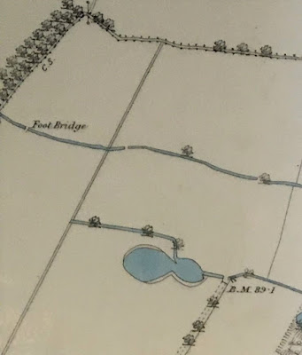
A map .....some ponds .... and a bit of the Longford Brook ……..

I am looking at one of my favourite maps of Chorlton-cum-Hardy.


It was produced for the Withington Local Board of Health in 1881, and I have Ricard Bond to thank for copying this section.

The Withington Local Board of Health was established following the Public Health Act of 1876, and covered the four townships of Burnage, Chorlton, Didsbury and Withington, and along with building the sewage works commissioned the map.

It is a beautifully detailed map and I have chosen the section which covers the area to the west of what is now the library stretching almost as far as the Longford Estate.

There is much to take in including the 27 properties that made up Fielden Terrace which was a community in itself, along with the Longford Brook, the Canal Feeder and the set of ponds some of which will have been the result of excavating marl and clay, a practice which went back to the 17th century.

These I have written about over the years and came back to recently.*


What I had never noticed before was the footbridge across the Longford Brook, which I guess vanished when this stretch went underground, leaving just a small section through Longford Park open to the sky. There are those who can remember when it was still there to see.  Equally another short bit in front of Copley Road was still exposed as late as 1934.

Just when most of it went underground is as yet unclear.  It was there in 1907 but had vanished by 1933.

And that is it.


"Although I copied the map, I also did not notice the footbridge until much later. As you say, this is a bridge over Longford Brook, not the canal feeder - the canal feeder is the watercourse running parallel to the Longford Brook, a little to the south, so OS have mis-labelled it. The section with the footbridge was culverted by the time OS surveyed a new map in 1892, see https://maps.nls.uk/view/126523724#zoom=5&lat=7759&lon=9124&layers=BT 

Note that the trees shown at top left are roughly where the present tree line of the eastern boundary of the disc golf course is located. The trees marked the then eastern boundary of the Longford estate but between 1876 and 1881, John Rylands and the Lloyd family exchanged lands, the result being the artificially straight boundary line running roughly N-S, to the east of the foot bridge. By 1892, Enriqueta Rylands had planted the present line of poplars, next to the boundary with Ryebank Fields, to mark the new boundary of her estate".

Location; Longford Road

Pictures; west of Martledge close to the Longford Estate, 1881 from the Withington Local Board of Health map, 1881,courtesy of Trafford Local Studies, and copied by Richard Bond

*Of clay pits ...... meandering streams …….. and plenty of ponds …… walking west of Martledge in 1854, https://chorltonhistory.blogspot.com/2021/11/of-clay-pits-meandering-streams-and.html


Friday, 13 February 2026

Who knew Derrick A. Lea of Illustrations & Design?


I am looking at one of eight illustrations produced by Derrick A. Lea.  

My eight are all greetings cards, some of which have a Christmas message and others with a more general inscription.

Of the eight, five are of Chorlton, one of Longford Hall and another of the Old Parsonage in Didsbury.

Now this does not surprise me over much because Mr Lea gave his address as Rybebank Road, and earlier in the 1950s he had been living on Dalmorton Road which is in between Egerton Road South and Kings Road.

But that is about all I do know of the chap.  So far I have discovered he was born in Bucklow in Cheshire in 1920, got married in 1949 and produced these fine pictures of south Manchester.

My eight belong to Margaret who bought a job lot some years ago using them as cards for friends and relatives.

Luckily for me she retained these last eight.


And the one I have in front of me is one of the lost buildings which only went in the last decade of the last century.

This is Longford Hall “the residence of the late John Rylands, was bought by him in 1855 and acquired by the Stretford Council in 1911.  The park and playing fields were extended by the purchase of additional land from Manchester Corporation and is much used for sport and other social gatherings.”*

Like many people I let this building go by with little thought about what was lost when it was demolished.

So I shall come back to Mr Lea’s Longford Hall in due course, but in the meantime I am still at a loss to know more about the man.

It was drawn in 1957 and some of the others of the eight date from the years around that time. Others have no date but I guess will be contemporary.

What makes them fascinating is that they cover a period when Chorlton was continuing to change.

I can not however date when they were made into cards but some at least have a telephone number containing the old mix of letters and numbers.

Now the switch to all figure dialing began in 1966 and was completed four years later and Manchester was one of the first cities to make the change.

All of which places the cards no later than 1970 and possibly earlier.

Margaret had seen the cards advertised sometime in the mid 1970s by Mrs Lea and went round to the house on Ryebank and bought a selection.  I would like to know more but that at present is all there is

But at least we his pictures.

Picture; Longford Hall, by Derrick A. Lea

*text by Derrick A. Lea

Monday, 26 June 2017

In search of the Black Brook as it flows through Chorlton


It exists that much I know, because it is there in contemporary accounts from the 19th century and even showed up in a joint local authority report on “strategic flood risk assessment.*

It seems to have run along what is Upper Chorlton Road, crossing north of the Library and then out to Longford Hall feeding a largish pond not far from where Longford Road joins Ryebank Road.

Our local historian Thomas Ellwood mentions it in one of his articles in 1885 linking it to a “footpath from West Point to Brooks’s Bar as a means of communication between Hulme and the village, along which a brook ran, afterwards arched over and utilised by Mr. Brooks as a main sewer for his property, which he drained into the watercourse called Black Brook. The brook frequently flooded the footpath during heavy rain, and old William Hesketh, who lived at the Pop Cottage, was often awakened at night by the cries of travellers for help and guidance through the water.”**

And just a year later turns up in a letter to the Manchester Guardian from a T. Clarke of Athelstone House, High Lane, who drew a connection between the watercourse and “fevers of a malignant character.” “If you take the Manchester Road, in the Black Brook, immediately by the ‘Oswald’ you will have a place of danger and offence.  I believe the ‘The Oswald’ has several times been visited by fevers of a malignant character”***

‘The Oswald’ or Oswald Field was roughly a little north of the library and extending to Oswald Road. From the early 19th century there was a row of cottages here and by the 1880s Oswald Lane ran from Manchester Road up to Oswald Road.

Today only the little stretch of that original Oswald Lane from Manchester Road survives having been re cut in the 1980s, but its old route is preserved in the footpath which continues on to join Oswald Road.

Looking at the 1841 OS it is possible to see the course of the Black Brook, hugging the edge of Oswald Field before running into the biggish pond and onto Longford Park.

By then it was fully culverted. Tracking it back further east is difficult.  It flowed for a while along what id Manchester Road and must have headed north to towards Upper Chorlton Road, but this would take it directly across the path of Longford Brook.

And that is the problem.  That wonderful book The Lost Rivers of Manchester by Geoffrey Ashworth mentions a Black Brook but that is much further east and any way becomes Cringle Brook out by Burnage which leads me to another communication with the Environmental Agency and a closer scrutiny of the SFRA document.

Meanwhile someone will write in to tell me the exact course and the mystery will be solved.

Picture; Oswald Fields, from the OS map of Lancashire, courtesy of Digital Archives, http://www.digitalarchives.co.uk/

*Manchester City, Salford City and Trafford Councils Level 2 Hybrid SFRA, Maps Index, Final March 2011
**Thomas Elwood, History of Chorlton-cum-Hardy, Chapter 6, Roads, December 12th 1885
***The Sanitary Condition of Chorlton-Cum-Hardy, Manchester Guardian May 19th, 1886.

Sunday, 15 March 2026

When Mr. Lea drew Chorlton-cum-Hardy …………..

I have Jon and Hazel to thank for reigniting my interest in our local artist Derrick Lea who I first came across a decade and a bit ago.

Seven in one place, Chorlton-cum-Hardy, in the 1950s
Back then I knew nothing of Mr. Lea other than that during the 1950s he produced a collection of fine pictures of Chorlton-cum-Hardy.

They were drawn in a style which will be familiar to anyone who grew up in that decade and are now unique in being a record of the township over 70 years ago.

They include some of our iconic buildings from the Horse and Jockey, and the Con Club, as well as the Lloyds, Barlow Hall, Hough End Hall and Jackson’s Boat along with Longford Hall.

Now I know some purists will sniffly point out that neither Hough End Hall nor Longford Hall are in Chorlton, but as Mr. Lea made an exception in his calendar of Chorlton sites, I am not going to quibble.

The Lloyd Hotel and Con Club, 1955
As for Hough End Hall it is true it was in Withington for centuries but with a slip of the municipal pen has now come over to us.  As for Longford Hall, yep, there is no denying it is in Stretford, but than Mr. Lea lived on Ryebank Road which is as close as you can get to the hall.

He was a commercial artist, and his son Jon tells me that he produced the Chorlton selection for picture postcards and that calendar.

All date from the 1950s and some I can pinpoint to a specific year. So, the images of the Lloyds, the former Conservative Club and Jackson’s Boat date from 1955 and that of Longford Hall was drawn two years later.

And that makes them an important addition to our understanding of what the area was once like and in particular how some of the buildings have changed over seven decades.

Hough End Hall, circa 1950s
When he drew Hough End Hall it was still part of a working farm and so while its glory days were over when it was at the centre of an estate comprising 250 acres its pond and fields were still home to chickens, pigs, geese and horses. 

Moreover, the last real tenant had only died a few years earlier which resulted in it being taken over by the Bailey family who first began farming in Chorlton in the mid 18th century round about the time the Hall passed out of the Mosley’s possessions who built it and into the hands of the Egerton’s who owned almost all of Chorlton.

Likewise, two images of the Horse and Jockey show that the western end of the pub was still a separate residential property.  

The Horse and Jockey, 1955
That said Mr. Lea was not above introducing a few flights from historical accuracy. In one of the Jockey pictures he includes a pond on the village green which fronts the Jockey. Sadly, there is no evidence for a pond and during a big chunk of the 19th century the green was the private garden of Samuel Wilton who lived in the eastern side of what is now the pub.

But that is a minor quibble when set against the bigger picture which is of a collection of images drawn during the 1950s by Mr. Lea, and which are fast fading from living memory.

And that is it.

Location; Chorlton

Derrick Lea, date unknown


Pictures; The Chorlton-cum-Hardy Mr. Lea drew in the 1950s, courtesy of Jon and Hazel Lea


Next; Longford Hall, Didsbury and out beyond into Cheadle and beyond