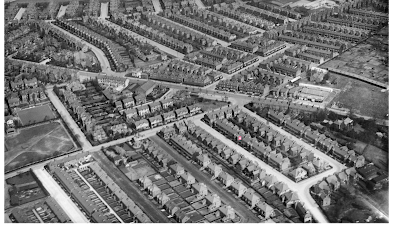
I like aerial photographs of Chorlton and this one has the lot.
My friend Bill sent it over and it comes from Britain from Above.
And what makes it particularly special is that there, to the left is Beech Road, the Rec and our house.
It was taken in 1927, and the picture offers up some interesting detail.
There is a tram cruising down Barlow Moor Road, and there is still some open at the top of Beech Road by the tram terminus. That land I think was built on sometime in the 1950s or 60s.
And looking carefully at Beaumont Road, it is just possible to see the old farmhouse set back from Beech Road, which Scott the builder didn’t demolish until sometime in the 1930s.
Its replacement I am fairly confident was not built until after the war in 1945.
Which just leaves the eagled eyed to spot that to the north of Rec, there is still the bowling ground belonging to the Masons.
This would not become a carpark until the early 1960s.
And the photograph clearly shows the farmyard of what had once been Bailey’s Farm, and would not become Ivy Court until the late 1970s.
 |
| Looking down on my bit of Chorlton, circa 1930s-40s |
And what makes it particularly special is that there, to the left is Beech Road, the Rec and our house.
It was taken in 1927, and the picture offers up some interesting detail.
There is a tram cruising down Barlow Moor Road, and there is still some open at the top of Beech Road by the tram terminus. That land I think was built on sometime in the 1950s or 60s.
 |
| Beech Road, a lost farm, the Rec and a bowling green |
Its replacement I am fairly confident was not built until after the war in 1945.
Which just leaves the eagled eyed to spot that to the north of Rec, there is still the bowling ground belonging to the Masons.
This would not become a carpark until the early 1960s.
And the photograph clearly shows the farmyard of what had once been Bailey’s Farm, and would not become Ivy Court until the late 1970s.
 |
| On Barlow Moor Road |
I could go, but that would spoil the fun, so I shall close by pointing to the buildings on Barlow Moor Road, just south of Beech Road.
The Chorlton Ballroom is still looking splendid, and it would be many decades before it became a series of nightclubs, before being knocked down for a fast food outlet.
And beyond the ballroom, there is Lime Bank, which dates from the late 18th century.
So I shall just thank Bill Sumner who found and sent the image over to me.
Location; Chorlton
Picture; aerial photograph of Chorlton, 1927, Britain from Above, EPW 017620
I’m wondering if this is part of the same series as a picture we have of the Sandy Lane area. We bought it 20+ years ago from a guy selling them on the doorstep. On the back it says it was taken in May 1946 by the RAF and is Crown copyright. You can see some of the site of some bomb damaged houses in the local streets. I’d send you a picture, but it doesn’t seem to be possible here.
ReplyDeleteThe website gives a date of 1927, see https://www.britainfromabove.org.uk/en/image/EPW017620
ReplyDelete