Tuesday, 6 February 2024

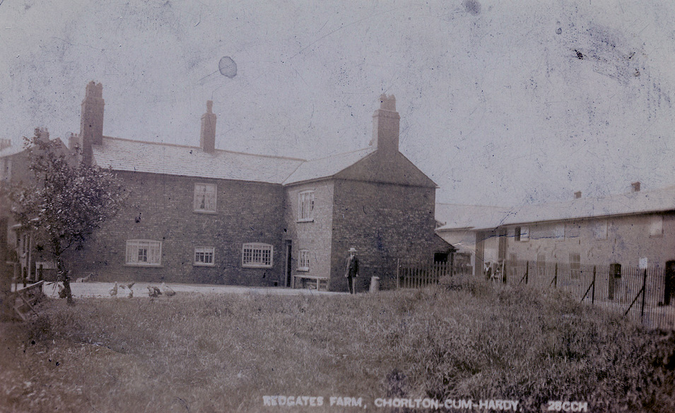
On Manchester Road with Uncle John at Redgates Farm at harvest time

We have been making our way down Manchester Road from the junction of Barlow Moor and Wilbraham Roads around the year 1910 and I thought that was pretty much the end of the journey for a while.

But you can’t be on Manchester Road just by the Library where the road swings to the north without mentioning Redgates Farm.

It dates back certainly to the late 18th century and maybe older and 1910 it was just about to disappear.

So I grateful to Carolyn Willits who supplied me with this picture when it was still a working farm, which is why I like this one of Red Gates Farm.

It is all more exciting because one of the men staring back at us is her Uncle John who worked on the farm for the Wood family.

I guess we are looking at the farm on a Sunday in late summer.

It is a quiet enough moment on a working farm. John and the other chap are out of their everyday working clothes into something smarter as befitting a day off.

To the right of the picture are the farm’s chickens pecking away and even further to the right some farm equipment has been left propped up against the tree.

The picture is actually a postcard and reminds us that travelling photographers would record scenes like this to sell back to the residents as well to commercial postcard companies. In this case Uncle John used the card to send a message to the Wood Family.

And we can date the picture to sometime before 1906 when the postcard was sent to James and Florence Wood at 78 Manchester Road.

James was the son of Thomas Wood who had been farming Red Gates since 1881.

Now it might seem bizarre that Uncle John would send a postcard from Red Gates which was just a few minutes’ walk from number 78 but that was how they did it then. With frequent collections and deliveries in a day people did really send a card in the morning to arrange to meet in the afternoon.

Ours was sent at 8.30 in the evening to arrive at breakfast time and the message was simple enough “Another view for your collection taken while harvesting.” And it was to be one of the last.

Thomas Wood the farmer had died in 1902 and sometime in 1913 or ’14 the farm house was demolished to make way for the new library. It says much for the way that Chorlton had changed since Thomas Wood had taken over Red Gates.

It had been one of the larger operations at this end of the township and had still employed three farm workers in 1901. But Thomas Wood was the last to farm Red Gates.

Already two of his sons had chosen not to follow him. James had become a commercial clerk and John a music teacher.

Their farm house with its seven rooms went the way of many of our farm houses, so it is good that Carolyn’s picture has survived.

Picture; Red Gates Farm circa first decade of the 20th century from the collection of Carolyn Willits.

Monday, 5 February 2024

Looking towards Oswald road ......another scene of lost Martledge from 1880


I have been visiting Martledge which has passed out of common knowledge, but was that part of Chorlton roughly from the four banks up to the Library.

Until the 1880s it was like most of the rest of our township a collection of cottages, farm buildings and open land.
 And in the summer and winter of 1882, Aaron Booth who lived at Sedge Lynn took a series of photographs of the area around his house.  This was Sedge Lynn and stood on the corner of Manchester Road and Nicholas Road.

He was a comfortably off business man who owned a packing business employing 7 men, and sometime after 1881 the family moved from Ardwick to Chorlton.  Only four of his photographs have survived but they are a rare insight into what Martledge was like.

Today I have chosen a picture he took from an upstairs backroom window looking out across what was called the Isles and is now the land stretching out along Oswald and Longford Roads to Stretford. In 1882 it was what it had always been, an open expanse of land dominated by ponds which had been dug out for marl for the fields and clay for house bricks.   The ponds were fed by little streams long since vanished.  Away to our left had been a row of cottages but the rest was just open land.

I rather think for any child it must have been a pretty wonderful place to roam, particularly on a warm summer’s day with little in the way of noise save the odd buzzing insects.  As a parent I might feel less happy.

There were I remember 17 ponds around what was Oswald Field where the cottages were and some were quite large and quiet deep.

Picture; from the Lloyd collection

Travels through Chorlton in February ……. memories of Christmas Day


So ..... on February 5th I wonder about the discarded Christmas tree and assorted empty bottles.

Are we gazing at the tree which has just been forgotten?  Or did its owner only just accept it had to be thrown out along with the unwanted  cans of beer , wine bottle and festive used coffee cup? 

Location; Albany Road

Picture; Memories of Christmas Day, 2024, from the collection of Andrew Simpson


Sunday, 4 February 2024

Robert Rose ... The Bard of Colour .... Manchester 1849

By chance I tuned into Testament to Rose on Radio 4 today.

Liverpool Road close to Byrom Street, 1860
And it has set me off on a search for Robert Rose who described himself as the Bard of Colour.

I know that after living in Liverpool he moved to Manchester where he wrote some fine poetry.

So far all I have is his burial plot number in Manchester General Cemetery and an entry for a Robert Rose "author" living off Byrom Street in Castlefield in 1841.

So I shall keep looking for him and in the meantime listen again to Testament to Rose, which the sleeve notes introduce Mr. Rose,

"When beatboxer and poet Testament discovers a mixed-race poet once lived and prospered 200 years ago in his hometown of Manchester, he’s captivated.

He sets off to talk to historians, a librarian and even a descendant of one of Robert Rose’s friends to find out what he can about The Bard of Colour – Rose’s self-given title. In Britain’s oldest public library, Chetham’s Library, Testament handles one of Rose’s notebooks, marvelling at his beautiful handwriting.

Tonman Street, near Byrom Street, 1850
What was the half-Guyanese Robert Rose doing here, in Victorian Manchester, on a generous private income, wining and dining with people of influence? 

Educated at public school, who were his patrons? Who were his parents? 

Why is he obscured from history? And is his poetry any good? A resounding "Yes!" from poet, novelist and fellow Guyanese David Dabydean who, like Testament, is excited to discover the work of Robert Rose.

A radical unafraid to speak up against slavery, a man with a vivid social life and many good friends, Rose was nevertheless far from home. 

Paterson Joseph brings Rose’s lyrical verse to life, some of it full of longing: "A wanderer here, O! Who for me would mourn/If the vast sea of life should o'er me close?"

Presented by Testament

Contributors: David Dabydeen, Lucy Evans, David Altson, Fergus Wilde, Michael Kelly, Jeanne Carmont, Voice of Robert Rose: Paterson Joseph, Research by Glynis Greenman, Additional recording: Ed Heaton, Produced by Nija Dalal-Small, Executive Producer: Mel Harris, Sound Design by Eloise Whitmore, A Sparklab production for BBC Radio 4"

Pictures; The former station on Liverpool Road, S. Langton, 1860, m62891, St Matthews’s Church, 1850, m71038, courtesy of Manchester Libraries, Information and Archives, Manchester City Council, http://images.manchester.gov.uk/index.php?session=pass

*Testament to Rose, BBC, Radio 4, https://www.bbc.co.uk/programmes/m001w0v2

Lazy history …….

 Well, just occasionally I break the cardinal rule, don’t do then and now pictures.


But rules are meant to be broken  ……. sometimes, and so here are two of the Rochdale Canal as it flows from Knott Mill into the Castlefield Basin.

Something like 44 years separates the two.

The first was taken using a camera which relied on smelly photography and the second the all singing digital replacement.


Of course they are not exactly taken from the same spot, but close enough.

I could have written about the transformation of the canal over those 40 plus years but I have done that heaps of times and anyway this is lazy history.*

Location; the Rochdale Canal

Pictures; the Rochdale Canal, 1979 and 2023, from the collection of Andrew Simpson

*The Rochale Canal, https://chorltonhistory.blogspot.com/search/label/The%20Rochdale%20Canal

Sedge Lynn …….. the missing picture

Now I am looking at a photograph of Sedge Lynn on Manchester Road.

Two Sedge Lynn's .... for the price of one picture, circa 1907-1920
It stood on the site of what was the cinema and later still the Co-op Undertaker’s and its name has now been appropriated by the Wetherspoons pub which in turn was once a temperance snooker hall.

The house dates from 1882 and was the home of the Booth family, who occupied it from when it was built till it was demolished in 1919 or 1920.

It consisted of eleven rooms and the rear offered up views across the fields towards Stretford.

Sedge Lynn, circa 1907-1920
The house and the family have fascinated me for a decade, and I have written about them along with the story of the cinema and the temperance hall. *

Mr. Arron Booth was a successful businessman and a photographer, and we have some fine pictures taken by him of Chorlton in the 1880s, including one looking out on the back garden and across to Longford Hall when the area was still open land and known as the Isles.

One of his daughter’s Ann Shepley Booth owned a private school on High Lane which later transferred to Napier Road, in what appears to be a swap with a Mr. Dadley.

He ran a Grammar school was looking for a larger premises and so transferred his school to 59 High Lane, and later extending into the neighbouring property.

But for those more interested in the Weatherspoons next door, is that irony that it began as a temperance hall, built by the Temperance Billiard Halls company with office in Pendleton.  In 1911 the company had halls across the city and beyond.**

The Temperance Hall, circa 1907-1920
These included Moss Lane East, Stockport Road, Rochdale Road, Ashton Old Road, Bury New Road, Broad Street, Eccles New Road, Liverpool Road, Station Road, Altrincham, Cross Street Sale, Manchester Road, Chorlton-cum-Hardy, Wilmslow Road, Rusholme, Hyde Road in Gorton, Stretford Road, Old Trafford and Cheetham Hill Road. 

All were built to a basic design with those large windows along the roof to admit the maximum amount of daylight.  Some still survive but have morphed into different uses, from a restaurant in Urmston to garages and supermarkets.

Ours in Chorlton long ago lost its temperance connection but remained a place to play snooker until quite recently.

Leaving me just to thank George Cieslik who kindly gave me permission to use the image and point out that the lamp post outside the house was still there in the 1950s.

Location; Manchester Road, Chorlton

Picture; Sedge Lynn circa 1907 -1920, from the collection of George Cieslik

*Sedge Lynn, https://chorltonhistory.blogspot.com/search?q=Sedge+Lynn

**Temperance, https://chorltonhistory.blogspot.com/search/label/Temperance


Saturday, 3 February 2024

The tree …… Marsh Leach Meadow and Mr. William Whitelegg

So, it started with a picture of the tree on Manchester Road beside the bus stop and the Co-op Undertakers.

Tree shapes, 2022

It isn’t a particularly old tree, although someone with more tree knowledge might correct me.

But it got me thinking about what this stretch of Manchester Road would have been like in the middle of the 19th century.

And yes, the OS map for 1854 shows a line of trees advancing up along the road from Longford Brook to Dark Lane.

Manchester Road, 1854
Inconveniently back in 1854 our tree was not there.

This I know because both the 1854 map and the slightly earlier tithe map show the road treeless as as far as Red Gates Farm up to the Longford Brook. 

They were Egerton land and farmed by William Whitelegg who lived at Red Gates Farm which is now the site of the Library.

The two fields were called Long Field and Hulme Marsh Leach.

Long field was farmed as pasture and its neighbour Hulme Marsh Leach was a mix of arable and meadow land.

While opposite on the other side of the road were King High Marsh, Horse Field and High Meadow which were arable and meadow.

You won’t find Longford Brook, it had already been culverted by 1854 while Dark Lane is now Buckingham Road.

And these too were farmed by Mr. Whitelegg who in total rented 68 acres and could include in the roll call of field names, Gilbury Marsh, United Field, Brick Croft Barn Pit,  and Long Dog Platt.

Along with an orchard of 2 acres and a small garden where he grew a selection of fruit destined for the Manchester markets.

Location; Chorlton

Picture; Tree shapes, 2022, from the collection of Andrew Simpson and Manchester Road, 1854, from the OS map of Lancashire, 1854, courtesy of Digital Archives Association, https://digitalarchives.co.uk/

Additional material from the Tithe Schedule, 1845