This will either seem a fascinating exploration of a forgotten bit of our past or confirmation that I need to get a life.
 |
| That brick wall, 2023 |
But I have become fascinated by the detail on this picture which I took last week down by the Rochdale Canal.
Like countless others I have passed it heaps of times and never gave it a thought.
Today it carries the tram which connects south Manchester, Salford and Altrincham to the city centre and beyond.
Added to which the arches to the left of my bit of brick are now home a collection of bars, and restaurants known as Deansgate Locks.
 |
| Those stone yards, 1851 |
And so back to the wall, which offers up the question of why is there a stone section at the bottom?
It may just be the solid stone foundations, but I rather think it may be more, particularly given the arched window which long ago was blocked off.
Looking at maps from the mid-19th century, all of the north side of the canal from Albion Street almost to Deansgate were a mix of stone, timber and coal yards and our spot stored stone.
The rate books for the period offer up eight names of people who may have run our stone yard, and I rather think ours may have been the business of a John Routledge, but that is based purely on his proximity in various records to the Albion Street end of that series of yards.
So it may be that the stone wall with its bricked-up arch ran beside the canal and Mr. Routledge’s business.
He and his family appear in the historical records.
In 1851 they were living on Stretford Road, and he described himself as a “Stone mason employing 40 men”. Their home must have been a busy one give that along with the seven children Mr. and Mrs. Routledge shared the house with a niece and two servants.
 |
| Railway lines, 1900 |
And that is my assumption that this stone wall supports the viaduct that carried the railway out of Central Station to Chorlton, Didsbury, Derbyshire and London.
An easy assumption to make given that the tram now follows the same route as far as East Didsbury.
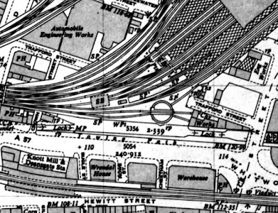
But no, the great viaduct joined a little further east, while running alongside the canal were a series of railway lines including a turntable which terminated close by Trafford Street.
And beside those lines directly facing the canal is a building which appears all all the later maps.
 |
| Trafford Street and the Canal, 1950 |
Of course, as soon as the story goes live someone will be able to offer up more information, with pictures and personal recollections.
We shall see.
Location; Whitworth Street, Manchester
Pictures; Bricks and things, Rochdale Canal, 2023, from the collection of Andrew Simpson, the Rochdale Street and Trafford Street, 1851, from Adshead’s map of Manchester 1851, and in 1900 from Goads Fire Insurance map, courtesy of Digital Archives Association, http://digitalarchives.co.uk/
No comments:
Post a Comment