This is CC 9305, and its story is bound up with the history of public transport and the leisure industry from the 1930s, but it is also intimately linked to our family.
 |
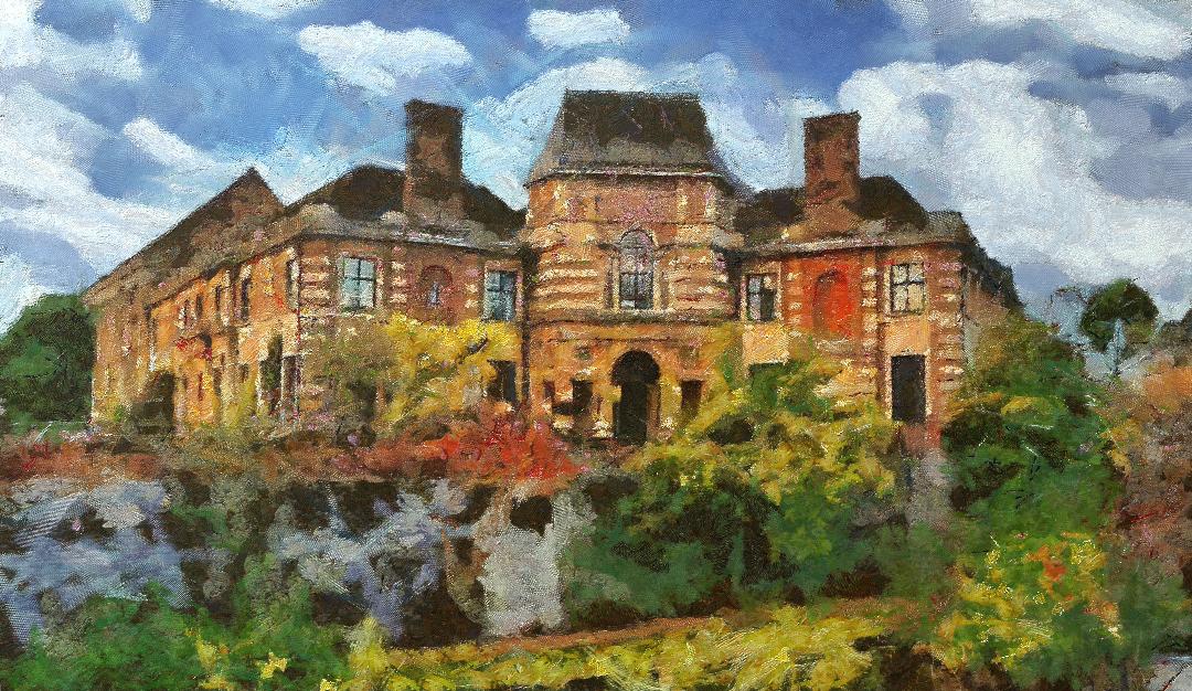
| CC 9305, 2025 |
I came across its existence by pure chance earlier in the week and tracked it down to
Dover Transport Museum where it has resided for 40 years.*
The chairman of the museum told me that it “is a 1929 Dennis GL fitted with a "toastrack" body by J. Roberts for Llandudno Urban District Council who used it for tours of the Great Orme until 1953 and was acquired in the 1960s by Glenton Tours of Peckham Rye and still carries the Glenton Livery”.
And in those two sentences we cover the early years of motor manufacture, the emergence of coaching holidays and two companies which are part of that history.
CC 9305 was made by Dennis Brothers Limited which my Wikipedia tells me “was an English manufacturer of commercial vehicles based in Guildford. It is best remembered as a manufacturer of buses, fire engines and lorries (trucks) and municipal vehicles such as dustcarts. All vehicles were made to order to the customer's requirements and more strongly built than mass production equivalents. Dennis Brothers was Guildford's main employer.”.**
 |
| Happy chara travellers, undated |
And as you do I followed this up with a visit to
Grace's Guide To British Industrial History which chronicles in great detail the emergence of the firm from one which began in 1885 making bicycles and progressed through motor cycles to a variety of vehicles which whizzed across our roads during the twentieth century.***
So, to CC 9305 made in 1929 and customised as a touring vehicle for a local authority doing the business until 1953. It was just a motorised char a banc replacing the older horse drawn version.
In the collection I have pictures of both which often feature groups of day trippers out for a “jolly” into the countryside or on one of those beery excursions to the seaside via as many pubs as could be found.
 |
| Horse drawn chara, undated |
We called the latter
"beanos" and were often a workplace adventure, although I guess any organizations went in for the day trip out taking in beauty sights, churches or the houses of the great and the good.
And that brings us to dad whose career was in the leisure industry ferrying happy and maybe not so happy holiday makers across the country and beyond onto the Continent.
Like Toad of Toad Hall, he was fascinated by motor cars and having forsworn a place at grammar school was working with buses and coaches by 1922 and always described himself on official forms as either a “Motor engineer” or “Motor mechanic”.
And some time in the 1930s he left the North East for London securing a position as a driver for Glenton Tours and quickly became one of the two drivers taking Glenton coaches across Europe, to France, the Low Countries, and on to Switzerland, Austria and Germany.
Only the war interrupted the holidays, but with the return of peace dad and Glenton Tours were back on the road.
 |
| Travelling with Glenton's, 1963 |
The firm was never backward at promoting themselves and they regularly advertised in the quality newspapers, often with a lightness which suggested a company who mixed seriousness with the silly. So, in 1963 the Observer carried an advert announcing
“Snobs & Char-a-bancs are out of date. Dowagers and flower sellers equally enjoy Glenton Coach Cruises. Knowledgeably planned routes, first class hotels and superb char-a-bancs (sorry coaches).***
 |
| Dad and Glenton travellers, Gindleward, Switzerland, undated |
I don’t know if these ads worked but mother always liked them and was impressed with the anonymous copy writer.
And some time around “Snobs & Char-a-bancs” Glenton’s acquired CC 9305, gave it the company livery and used it to promote the firm.
That work will have been done in their garage in Nunhead and given that dad worked in the paint shop in the winter months he may well have been involved with its makeover.
 |
| Back almost where we started in Dover with CC 9305 |
All of which makes CC 9305 special and rekindled long forgotten stories from dad about the Glenton’s Char-a-banc.
He retired in 1986, and sometime after the firm closed down, just when I have yet to find out, but there is a clue which comes from the archive of the Dover Transport Museum in the form of a letter dated 1996.
In that letter a Ms Kenny comments on the purchase of one of the coaches and refers to “Glenton 121 Group”.
So far, I have only found a few references to the group and pretty much all are a record of them participating in vintage vehicle rallies.
But someone will know, and with that I will get a bit closer to the story of Glenton Tours and where they fit in the history of the luxury coach trade.
And a long the way I may find out a bit more of CC 9305, whose story goes dark between 1953 and its acquistion by Glenton's. I am hoping that the archives of the Dover Transport Museum my reveal details of the lost years, and here I have to thank the museum for their help in revealing its history, allowing me to reproduce a picture of the vehicle and their promise to trawl their records for more information.
Which in turn will contribute to Glenton’s story.*****
 |
| Doing the biz of having fun, undated |
Well, we shall see.
Location; with Glenton Tours and Dover Transport Museum which is open from 1030 to 1630 every Wednesday, Sunday and Bank Holiday during the summer and autumn of 2025
Pictures; Glenton Tours memorabilia from the Simpson collection, CC 9305, courtesy of Dover Transport Museum, the horsedrawn char a banc, undated, from the Lloyd Collection and happy holidaymakes, undated courtesy of Ron Stubley
*Dover Transport Museum, https://www.dovertransportmuseum.org.uk/
**Dennis Brothers, https://en.wikipedia.org/wiki/Dennis_Brothers
***Grace's Guide To British Industrial History, https://www.gracesguide.co.uk/Dennis_Brothers
****The Observer, April 21st, 1963
***** Glenton Tours, https://chorltonhistory.blogspot.com/search/label/Glenton%20Tours