Thursday, 24 April 2025

Looking for the lost and hidden bits of Spinningfields

I have been reflecting on how that place between Deansgate and the River remade itself as Spinningfields.

Hardman Street 2025

To be fair it has had many remakes.  I knew it in the 1970s and 80s as an area waiting for something to happen with tired looking buildings.  Go back another twenty years and the scars of the last war were all too visible from what the 1951 OS map recorded as “Ruins” and open spaces.

Hardman Street and Byrom Streets, 1951
Slide back a century and a walk down Hardman Street from Deansgate would have offered up a busy densely populated network of streets, closed courts and small industrial units.  

On the corner of Byrom Street and Hardman Street stood William Murray’s livery stables which described itself as the “Horse Bazaar” while close by were Ashley’s Silk Mill, Hampson’s Hat Factory and Thompson’s Soda Water Works.

In between were heaps of houses occupied by families who worked in a wide range of trades, plenty of unskilled labourers as well as washerwomen and street hawkers.

To these we can add a significant number of “beer sellers”, brewing and selling the stuff from their own front rooms.  So, on Byrom Street there were three listed amongst a total of 23 properties, while Hardman Street boasted two beer houses nestling between the Golden Eagle, Victoria, and Hope Pole Taverns which together made up just twenty-five households.

Hardman Street and Byrom Streets, 1851

And to gain some perspective you just need to walk down those two streets today which are narrow and short to get an idea of how close all these drinking establishments were and how many people they served, because each of these streets led off into back streets, alleys and closed courts.

All of which is a direct contrast to how the area has turned out, with its tall glass and steel towers its bars, offices, and restaurants.

Each time I go there I have to think hard to recall the place I knew, and once again I am forced back on the collection of pictures, I took over four decades ago.

Hardman Street and Byrom Streets, 2025
Google maps shows the bright new Spinningfields while in 1981 the same spot was dominated by what had been “The Hospital for Consumption and Disease of the Throat” which still had inscribed above one door “Tuberculosis Office”.

It is reminder of a grim time when infectious diseases like TB were rife, and treatment was pretty much reliant on segregation, rest and fresh air.

To this day I am still horrified by the practice of spitting in the street which seems to be on the increase and which for my generation and earlier generations ran counter to public health campaigns still evidenced in old signs which can be found on some public places and vintage trains, buses and trams.

I had quite forgotten that hospital but a series of pictures I took in 1981 jogged my memory and took me back to that corner of Hardman and Byrom Street before today.

Hardman Street from Crown Square
It was a protest march which terminated like so many in Crown Square and had taken us from All Saints up Oxford Road to Quay Street and Byrom Street.

That said it took a bit of time to match the 1981 picture with the present spot.

But I did and along the way thought again about how places change.

Location; Spinneyfields

Pictures; Hardman and Byrom Street, 1981 from the collection of Andrew Simpson, and again in 2025, courtesy of Google maps, and the area in 1951 from the OS map of Manchester and Salford, 1851 and in 1849 from the OS map of Manchester and Salford, 1849, courtesy of Digital Archives, http://digitalarchives.co.uk/ 

Hardman and Byrom Streets, 1981

Yom Hashoah Holocaust Memorial Day

 April 23 April 24


Wednesday, 23 April 2025

From the swish to the seedy …..

For nearly sixty years I have wandered the city seeking out the narrow back streets along with the fine new public places which sparkle and shine.

Crown Square, Spinneyfields, 2025

And I delight in the contrasts between places like the new Spinneyfields with its mix of glass and optimism with the grubbier and almost edgy streets which long ago have almost been forgotten.

So, a few days ago I took myself off into Spinnyfields  which seems to be constantly on the cusp of change and as you do ended up a little to the north around Bridge Street, Southgate and King Street West.

Wagon and Horses and New Shambles Street, 1851
In the 1970s we would often dip off the main roads and end up in one of those back street pubs known only to a select band of locals and those who chanced on upon them.

And one we did frequent was the Wagon and Horses on Southgate, because it was close to the old cinema on Deansgate and was perfect for an early drink.

Often, we would be there just after it reopened in that waiting time after the shops and offices had closed and before the clubs and restaurants came into their own.

Which meant that on most nights there would be a mix of office workers and shop assistants finishing the day with a drink and the night people meeting up before they “did” the evening.

It was a time which I liked when this bit of the city went quiet after a busy day but was filled with the expectation of the fun which was just around the corner.

What I didn’t know when we sat in the Waggon and Horses in the mid 1970s was that it was doing the business of serving up beer as far back as 1851 when it was surrounded on two sides by the Pig and Carcase Market and the Bridge Street Market.

Southgate, 2025
Back then this bit of Southgate was called New Shambles Street which given the markets made perfect sense.

The road is quite narrow  and gives off onto Back Bridge Street, which is even narrower, becoming more an alley than a street.

It’s a bit neglected and long ago most of the properties along its track turned their backs on the street. Only halfway along where Butter Lane joins Back Bridge Street are there premises that you can walk into and buy something.

But if you carry on down our narrow street there is nothing much to see, except more recently this drum which stands in an open doorway.

I suspect it is used as a sort of table by the staff who work at the restraint which looks out on to Trinty Square.

It struck me as looking a little forlorn and matched the entire length of our street.

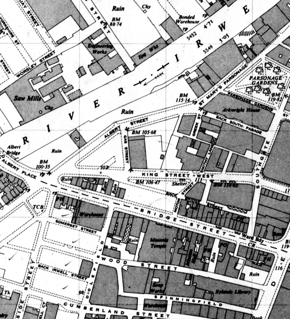
And not content I went looking for the story of the place over the century after it was surrounded by the markets.  In 1951 much of the area had suffered from the aerial bombardments of the Second World War and the OS map of that year shows areas marked “Ruins” along with heaps of open spaces and an air raid shelter on King Street West.

At the bottom of Back Bridge Street, 2025

Even here you sense chabge is on th eplanning table to which l have to say the Waggon and Horses is now Mulligans.

Southgate and surrounding streets, 1951

All a little different from Spinneyfields.

Location; Spinningfields and Back Bridge Street

Pictures; Crown Square, Southgate and Back Bridge Street, 2025, from the collection of Andrew Simpson and Wagon and Horses and New Shambles Street, 1851,  from Adshead’s map of Manchester, 1851, Digital Archives Association, http://www.digitalarchives.co.uk/ and Southgate and surrounding streets, 1951 from the OS map of Manchester and Salford, 1951

Tuesday, 22 April 2025

Lost in Spinningfields …….. with just the past as a guide

I must admit I do get confused in Spinningfields, or more accurately I get disorientated.

Looking down Hardman Street to Hardman Square, 2025

Even now almost two decades after the development began and following heaps of visits, I still lose my way and get a bit surprised at what I come across.

Looking up from Crown Square, 2025
But then most of the rebuilding happened while I was less focused on coming into town with the result that the place took off while I had my eyes elsewhere.

Added to which I remember it from the 1970s and early 80s when the area was best described as a place waiting for something to happen.

And that according to my Wikipedia began in 1997 when a property company purchased several buildings around the Rylands Library.  

The plan was to create a new business quarter and retail area which it dubbed a “Knightsbridge of the North”. *

Inevitably the business area was described as our equivalent of London’s Canary Wharf and by 2010 a report byLooking up  Manchester City Council noted that 16,000 people were employed in Spinningfields which accounted for over 35% of the City’s prime office space.**

And along with the offices, and a mix of restaurants has come residential towers and that footbridge across the river linking Spinningfields to New Bailey in Salford.

Hardman and Byrom Street, 1981

There will I guess be detractors, but I like the place, even given my ability to get confused.  It has a buzz and offers up plenty of photo opportunities but which do present challenges in matching my collection of old pictures with today.

Hardman and Byrom Street, 2024
So I looked out an image from the early 1980s of the end of anti-cruise missile demonstration.  It had begun in All Saints and snaked its way through the city before ending in Crown Square.  

The picture caught the last leg of the march as it made its way via Byrom Street, passing Hardman Street before terminating in the Square.

Standing at the corner of Hardman and Byrom Street recently it was hard to match that picture with the present.

Which I suppose explains my confusion.  It is a bit like staring through a very dirty window.  You can make out something but it is difficult to make sense of what you see.

That said the Spinningfields development has been so comprehensive that there is little left to remember, and you have to fasten on the remaining bits of the old street pattern. 

But that has a bonus because it always takes me back to explore the area in the past and that in particular in the 1840s and 50s when the area was a mix of back-to-back housing, as well as factories and markets.  Much of this was subsequently swept away with the development of warehouses, and offices which in its way was almost as comprehensive as its 21st century equivalent. ***

Hardman Street and surrounding streets, 1951
Which is where I came in, leaving me to ponder how as a resident of the area in 1851 I would have coped with wandering the streets a century later or today.

All I guess would be confusion.

Location; Spinningfields

Pictures; Hardman Street, 2025, and Hardman Street/Byrom Street in 1981 from the collection of Andrew Simpson, Hardman Street/Byrom Street, 2024, courtesy of Google Maps and Hardman Street and surrounding streets, 1951, from the OS map of Manchester & Salford, 1951

 *Spinningfields, https://en.wikipedia.org/wiki/Spinningfields

**Manchester City Council Report for Resolution, March 2010, https://www.manchester.gov.uk/egov_downloads/Spinningfields.pdf

***Spinningfields, https://chorltonhistory.blogspot.com/search/label/Spinningfields

The lost pubs of Chorlton, No 1 the Oaks Hotel


I am looking at a photograph of the Oaks Hotel taken in 1959 and it is pretty much how I remember it two decades later. 

 It had been built sometime after 1911 and catered for the cemetery trade. 

It was a huge rambling building with a fine staircase and plenty of rooms which would have suited cemetery parties.  I suppose in its heyday it must have been a crowded and boisterous place, but when ever  I dropped in it just seemed empty and a little sad.

Perhaps the fact that to get to it you had to pass a line of businesses catering in cemetery goods was not conducive to a happy night out. 

And I rather think R.E. Stanley caught it at its best.  By the 1970s and early 80s the elegant lamp posts on either side of the entrance had gone and the front and enormous back car parks were showing their age.

Thinking about it I suppose I only ever went there a few times and a part from a few locals I guess most of its clientele were the funeral parties.  It closed in the early 1990s and was demolished soon afterwards.

Picture; The Oaks Hotel, by R.E.Stanley, May 1959, m17565, courtesy of Manchester Libraries, Information and Archives, Manchester City CouncilThe Feathers, another lost pub published on Sunday October 14th

Monday, 21 April 2025

The missing three …. tales from the Rec

Odd what people discard on the Rec, and even odder when no one comes to retrieve them.


Early on one day last week I came across the discarded three mirrored by a fourth on a bench nearby. 

And a full  six days later they are still there …. testimony to the many different ways people use the Rec as well as the mystery of why no one came to claim them.


Location; The Rec

Pictures; the missing three and another, 2025 from the collection of Andrew Simpson 


Sunday, 20 April 2025

Stories of Easter ………..

I have always been fascinated by how comics have told stories of events from the past.

And that in part is due to the fact that I grew up in the 1950s with the Eagle, and its companion comics, Girl, Swift and Robin.

Together they presented young people with highly professional comics, which were well drawn, didn’t talk down to their readers and supplied a mix of entertainment and knowledge.

So, whether it was Dan Dare or the Four Mary’s, the stories produced by some of the best artists and story tellers were of the highest quality.

And along with factual cut away diagrams, and the tales of adventures, there would be biographical accounts which portrayed  living people as well as those from the past.

Given that this was the 1950s, they tended to be white, European, and in the case of the Eagle very male.

From what I know of the editorial policy of all four comics, I suspect that if they were still being published today they would reflect multi cultural Britain in their story lines, and in the individuals they featured.

But in 1950 and into the 60s, society and the media were slow to recognise the changes which were already underway.  These included  the Windrush, and those who arrived from different parts of Europe, after the war often from “displaced persons camps”, and a little later those from the sub continent.

Added to which there was that shocking collective amnesia which pretty much “forgot” the vital role that women played in fighting the war, whether it was in the services, in the factories or on the land.

I would be well into my teens before I fully appreciated what mother and other women did in the services, and later in war time factories, none of which appeared in the stories of heroic soldiers, sailors and airmen.

I wish it were otherwise but in 1960 it wasn’t, and that leads me to "The Road of Courge, The Story of Jesus of Nazareth", which appeared in the Eagle on the back page from March 1960 for 56 episodes, ending over Easter Week in 1961. 

It was drawn by Frank Hampson and it fitted well into the ethos of a comic which was the creation of the Rev Marcus Morris.

Not that I was particularly religious back then  and nor am I now.  But what I like about the comic strip is both its clear story line and above all the art work which at times has a feel of the cinema.

There will be those who criticise the portrayal of Jesus as heavily European which I would agree, and  perhaps sixty years on, if he were alive Mr. Hampson would draw him differently.

And that is about it.

Location, Easter

Pictures; from The Road of Courage, 1961, Frank Hampson