Tuesday, 30 April 2024

Ninety - nine stops ….. heaps of stories …. and a favourite tram destination

The publication of our first book in the new series on The History of Great Manchester By Tram has stirred the pot with plenty of people commenting that it’s a novel way to record the past. *

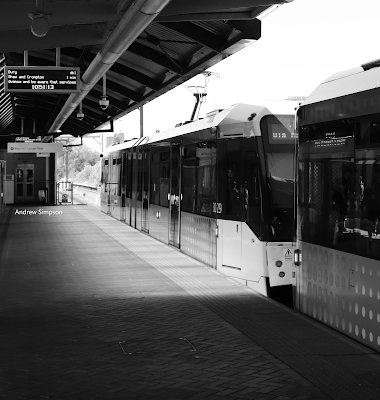
Arriving at Deansgate Castlefield, 2023

After all there are ninety-nine tram stops across the network and each one will have its own history.

Shudehill after the trams have gone, 2023
And so, Peter and I have decided to explore the entire Metro system, travelling the routes looking for interesting pictures and bits of history.

Peter will paint a picture of the stop and surrounding buildings, and I will find stories about each stop, which will build into a mosaic of tales about Greater Manchester’s past.

And it occurred to me that along the way it would be fun to find out which metro stop comes out as a favourite of those who use them.

I must confess to having several. 

Cornbrook is one because it affords fine views of two canals and the changing landscape as each year more new apartment blocks replace the old industrial brown field sites.

But then Deansgate Castlefield, also has a canal, the old Knott Mill Railway Station and is just a few minutes’ walk away from the city’s own Heritage Park, along with some fine bars and historic pubs.

Sneaking up on Mr's Pankhurst in St Peter's Square, 2022

And both of these stops vie with St Peter’s Square, which has a popular open space from which to take in Central Ref, the Town Hall Extension, the Midland Hotel and Mrs Pankhurst addressing an audience.


In addition, we are close to the Cenotaph, the site of the Peterloo Massacre and that other square which boasts a collection of statues.

Peter is attractedto several but it would be presumptuous of me to reflect on just why Shudehill and New Islington are on his list.

So, that is it.

You can nominate your own selected stop, including a picture and a  few sentences which can be sent to us as a comment via, the blog, social media or an old fashioned postcard.

Busy tram day, Deansgate Castlefield, 2023

Missing the tram from Cornbrook, 2024
Location; Ninety- nine spots in Greater Manchester


Pictures; my tram stops, 2018- 2023, from the collection of Andrew Simpson

*Trafford Bar to East Didsbury, The History of Greater Manchester By Tram, The Stories At The Stops, Andrew Simpson & Peter Topping, 2024.  

The tourists at St Peter's Square, 2018

It is available from Chorlton Bookshop, and from us at www.pubbooks.co.uk, price £4.99

Looking to a bright new future ............ history books from the 1950s

Now I have never lost my love of the children’s history books I read back in the 1950s.*

The cooling earth
And so I have returned with another old favourite, and lest anyone thinks this is just a bit of nostalgia I have to say that these books offer up a fascinating glimpse into how history was being written for children and how some writers had embraced the idea that the past is not just about Kings and Queens along with a few of the good and the powerful.

R.J. Unstead and Edward Osmond wrote social history which explored everyday lives and broke new ground by explaining how geography and nature played a part in shaping the history of our country.

The Fotress Home
Added to which there were an abundance of fine illustrations by some of the leading artists of the day.

Of these the pictures of Alan Sorrell and Ron Embleton stand out as excellent examples of historical accuracy matched by a realism which then and even now I find most compelling.

And so to The Pictorial History Book which was published in 1955.  It is a wonderful book covering the history of Britain from the very beginning of the Universe, through to the 1950s lavishly illustrated and offering a mix of short paragraphs with longer explanations of events and detailed fact summaries covering everything from timelines to biographies and data.

My copy I think must date from Christmas 1955 or soon after.  It is now very battered and in danger of falling apart, having lost its protective cover a long time ago, and yet it is still magic to read, and often is a first port of call for information long before those adult reference books or a trawl of Wikipedia.

The New Model Army
So yes, a tad nostalgic indulgence perhaps, but also an exploration of how history was being presented to young people in the 1950s.

And of course it has become history itself for the book drips with the optimism of the 1950s.

The last two pages FROM TODAY INTO TOMORROW, are full of pictures accompanied with comments about “cheap air travel will make distance of no importance, [with] Holidays in the tropics taken all year round, ........ the drudgery will be taken out of housework by many labour saving machines” and “students from the Commonwealth will come to Britain to be taught in our technical colleges and universities.”

All of which was introduced by “In recent years the idea has been accepted in Britain that no citizen should be left unhelped if he is sick or if there is no work for him to do.”

Now, that then, and now is a pretty sound way to sign off on a history book.

Pictures; from The Pictorial History Book, & Co, Ltd Sampson Low, Marston & Co, Ltd, 1955

*Books Children, http://chorltonhistory.blogspot.co.uk/search/label/Books%20Children

Voting in the General Election at Eltham in the November of 1837

In the November of 1837 the electorate of Eltham went to the polls.  

Well Hall in 1844 with Well Hall House a
All 67 of them, which if my sums are correct represented just over 13% of the adult male population and 6% of the entire adults in Eltham.

This did not compare well with some other places.  In the smaller rural township of Chorlton-cum-Hardy just 4 miles from Manchester the figures were 16% and 9% respectively which was better than the national average which in 1833 stood at just 7% of the adult population.

Worse still only 35 of the 67 lived in Eltham and those who didn’t passed most of the year in places like Chorley in Lancashire, Corbridge in Northumberland and Swinthrop in Yorkshire and even where their residences were in the south they were across the Thames on the other side of London.

And stating these figures is important given that only men had the vote and the qualification to vote was tied to property.  Some of our Eltham electors were tenants and this compounded potential inequality.

In an age when voting was still conducted in the open there was always the possibility of intimidation.  A tenant would cast his vote under the watchful eye of his landlord and the tradesmen would share his political choice with all his customers.

In General Elections the powerful made it known who their favoured candidates were and it took great courage for electors to ignore that stated preference.

Eltham Street now the High Street, 1844, Samuel Jeffyres lived near 309
The 1832 Reform Act may have been greeted by some as an attack on privilege and out moded electoral practices and it did abolish some of the more indefensible ways of electing MPs, widen the electorate to some of the middle class and give the great northern towns of manufacture a representation in Parliament.

But is also deprived some working people of the vote, continued to ignore women  and “if there was less rioting and less bribery at an election, there was still much bribery and more intimidation and election day was still a carnival which usually ended in a fight.” *

So just two years earlier in 1835 in South Lancashire the Tories claimed the Whigs owed a “very great proportion of their votes to the direct interference of the [Whig] Earls of Derby, Sefton and Sheffield “and “200 votes were given to Lord Molyenux and Mr Wood at Ormskirk because Lord Derby had expressed his sincere good wishes in their favour” **

This may well have been the case but pales in comparison with the actions of the Tory landowners to their tenants.  According to the Manchester Times & Gazette, *** Thomas Joseph Trafford of Trafford Park instructed his tenants to vote for Lord Frank Egerton & Wilbraham while Lord Wilton followed the same practice, instructing his tenants to vote for Lord Egerton and use their second vote for the candidate of their choice.

 In Stretford all but one of Trafford’s tenants voted the Tory party line. The level of potential intimidation was all too clear from the one tenant who refused to follow the line.  He expected “in the spirit of the olden times, to hear of Tory vengeance.” 

Now much research has to be done on the Eltham result of 1837 because our 67 electors did not march with the general swing of things in the great big constituency of West Kent.

Election result for West Kent, 1835
Five years earlier the Whigs had swept to power on the back of the Reform Act but a combination of Tory fight back and a slowdown of the pace of reform made the Whigs look tired and over confident.

And so the Tory Party made gains in both the 1835 and ’37 General Elections.

In West Kent the two seat constituency elected a Whig and a Tory, but in Eltham the vote went overwhelmingly to the Tory candidates.

Election result for the Eltham Division of West Knet, 1837
Now this we know because the choices the 67 made were recorded in the poll books.

Our old friend Samuel Jeffryes used both his votes for the Tories as he did again in 1847.

So matching the electorate to their landlords and charting the political preferences of these great landowners will be revealing.

But one should be careful. Intimidation is more likely to work on the small tenant farmer or shop keeper and men like Samuel Jeffryes who styled himself “gentleman” and eventually retired to Westminster to live may just have voted as his conscience dictated.

We shall see.

Location,; Well Hall, Eltham, London

Pictures; Well Hall and Eltham Street in 1844 from the Tithe map for Eltham courtesy of Kent History and Library Centre, Maidstone, http://www.kent.gov.uk/leisure_and_culture/kent_history/kent_history__library_centre.aspx

*Young G.M., Portrait of an Age Oxford University Press 1953 Page 28
** The Hull Packet January 30 1835
*** Manchester Times & Gazette January 3 1835
****Thomas Joseph Trafford 1778-1852, owned Trafford Hall and land in Trafford and Stretford

The unremarkable reveals its secrets ...... at Chorlton station in 1911


This is one of those pictures which don’t get included in the collections of Chorlton.

And you can see why of course.  There is nothing here at first glance which anyone would recognise so there is no point in trying to match it with the present.

Nor do we know who any of the four are and given that the photograph is over a hundred years old I doubt that we ever will.

So most of us would pass over the image and if pressed would label it “four men outside a brick hut, possibly industrial, date unknown.”

For me that is pretty much the attraction.  The date is given as circa 1909 and we are down at the Goods Office by Chorlton Station.

And with that small piece of detail the photograph begins to make sense and I think  starts being interesting.

Look closely and to the left there is a carriage no doubt waiting for someone off the train, while directly in front of the hut is the Public Weighing Machine and to the right the offices of the coal merchants.

In 1911 there were five of them working from the yard by the railway line along with J. Duckett & Sons, building merchants, and J. A. Bruce Alexander, nurseryman.

We may even be able to date more accurately when the picture was taken because according to the 1911 directory one of the firms working in the yard was a Frank Tinker and it is his name which appears above and on the office to our immediate right.

And so to the four. I still don’t know who they are, but one  is wearing a railwayman’s cap with the letters CLC, for the Cheshire Lines Committee which will take me down the route of searching out their staffing records.

The two in the doorway judging by their clothes may be clerical staff which I is confirmed by the sheaf of papers held by one of them.

So the brick hut will be connected to the Public Weighing machine, these are employees of the railway and we are down by the station in what is now the car park of the supermarket.

And looking back at the directories for the years before 1911 there is evidence that the number of coal merchants has grown reflecting I suspect how populous Chorlton was becoming and how successful had been the railway in the 20 or so years since it was opened.

And not long after this was posted I got one of those helpful comments from John Anthony Hewitt "Not really a public weighing machine Andrew Simpson, although it could have been used for that purpose as well as railway duties. 

It was most likely used for sale of coal and other materials, by weight, to local merchants. 

They would weigh-in empty wagons, weigh-out the same wagons laden with coal, etc., and calculate the bill. 

The person holding the papers could be one of the merchants judging by the non-railway style of hat being worn. 

He is also looking slightly bemused [at the bill], whereas the railway clerk has a broad smile on his face."

Location; Chorlton

Picture; from the Lloyd collection, 1911

Lost and forgotten streets of Manchester nu 29 ............... the one with two names

Now I have never walked the entire length of West Mosley Street which starts at Princess Street, and ends at Marble Street.


If I did I would cross first Nicholas Street, then Charlotte Street and lastly York Street.

It was there by the 1790s but twenty years earlier the area was just open land.

It is one of the twisty little streets which originally began at Dickinson Street which ran along the north side of St Peter’s Church

Today both of church and most of Dickinson Street have now gone, although a short stretch of  the street does still exist from Portland Street into St Peter’s Square.

Sometime in the 20th century West Mosley Street acquired its present name, which before that was simply

Back Mosley Street.

Location; Manchester

Picture; West Mosley Street, 2016, from the collection of Andrew Simpson

Monday, 29 April 2024

Recreating the lost Well Hall House with Edith Nesbit

Well Hall House from Well Hall Road, 1909
Well Hall House has passed out of living memory.

It was built in 1733, was home to some Eltham notables and was demolished in 1930.

It stood between Well Hall Road and the moat and replaced the Tudor manor house which Sir Gregory Page knocked down to build his fine 18th century house.

But a building which dominated Well Hall, and was known by many seems to have left little trace.  There are a few photographs a handful of maps and the land records of the tithe schedule.

Wll Hall, 1874
Together these show a tall building which ran to three floors, had a wing on each side and was set in an estate of about 33 acres including a front garden, a walled garden to the south, the moat , three ponds, a stream and much meadow and pasture land along with the farm buildings which included the present Tudor Barn.

A little to the north were Well Hall Cottages which in the 1840s had been a complex of six properties but by 1911 seem to have become a farm house and one cottage.

But Well Hall house was sufficiently enclosed that I doubt the cottages proved much of an intrusion, and so within its grounds the occupants of the big house got on with their favoured lives wandering the fourteen rooms and looking out east across the fields and west across their gardens.

Judging by the photographs I am not sure it was a place that would have caught my fancy.  It was tall and the design fitted that classical style of balance so that what you saw on one side was replicated on the other.

All of which is not much for a house which stood for just under two hundred years, but as these things work there is one other source of information, and that comes from Edith Nesbit, the novelist who lived in the house from the late 19th century into the twentieth.

Contained in some of her books are references to Eltham, Well Hall and the house itself.  And of these it is The Red House written in 1902 which provides some wonderful insights into the place.

The back of Well Hall House from the Paddock and moat, 1909
The book itself is a light account of the lives of a newly married couple who inherit the Red House and choose to live there.

In the course of the year that follows Ms Nesbit describes in some detail the house, its gardens, the nearby cottages with references to the village the parish church and offers up walk on parts for both Woolwich and Blackheath.

But it is the house which draws you in, with its panelled rooms, great hall, vaulted cellars and kitchen still with the equipment which would have been in use through the 18th and 19th centuries.

Added to this there are observations about the rooms which had been much messed about by changing fashion.

The front of Well Hall House, date unknown
Now like all such descriptions I suspect there will be points when the Red House departs from the actuality of the original, but I am confident that there is more that will have been the same than less.

This in turn stretched to her descriptions of the gardens, including the walled one, the presence of the railway with its station and embankment and the parish church.

Edith and her husband Hubert had taken on the house and 7 acres of the land.

Of course there may be more sources of information sitting in the Greenwich Heritage Centre and in the letters of the people who visited Edith and her husband at Well Hall which included the Webb’s, H.G.Wells and Bernard Shaw but in the meantime the Red House seems to have done the old place proud.

Location; Well Hall, London


Pictures; Well Hall House circa 1909,  from The story of Royal Eltham, R.R.C. Gregory, 1909 and published on The story of Royal Eltham, by Rob Ayers, http://gregory.elthamhistory.org.uk/bookpages/i001.htm and Well Hall House, from The Edith Nesbit Society, http://www.edithnesbit.co.uk/ map of Well Hall from the OS Map of Kent 1858-74

Melting tar …… a busy butterfly ….. and a long lost adventure

Now the thing about getting old is that there seems to be heaps more time for the memories of the past to invade the doings of a busy day.

Shallow ponds and lazy streams, 2018 
And once that flight of nostalgic fancy starts to run its course it is easy to reflect on how your experiences of 60 odd years ago diverge from those of your kids or grandchildren.

I say that, but much of what our sons did when they were younger are only now being revealed as in their own bouts of nostalgia, they share stories of daring dos which they wouldn’t dare to have admitted to when they were 10.

Some of those stories do resonate.  Their adventures on the meadows on long summer days, chime in with my own, when armed with just a warm bottle of lemonade and a day stretching ahead of us, we wandered off in search of adventures in some faraway park, or along a stretch of the Thames.

Often it was at the end of a train journey or the limit of a Red Rover bus pass, and it usually involved a quiet suburban spot, unhindered by other people. 

One such place was at the end of a railway line, and rather than explore we just sat on the platform.  

There were no trains, no passengers and the only sound was that of a lazy insect collecting pollen, mixed with that distinctive smell of mown grass, which competed with the equally powerful smell of the oil-soaked wooden railway sleepers cooking in the sun.

We must have sat there for hours before boredom and the empty bottle of lemonade prompted us to move on.

The spot where we played  with the hot street tar in 1958
These of course can be replicated by our kids, but those of exploring bombsites have gone as is the simple pastime of watching the tar slowly melt on a hot summer’s day sitting on the side of the road and carefully making patterns of the black oozy stuff with a discarded lolly stick.  

Today the street surface doesn’t melt, and the lolly sticks are no longer there in abundance.

And in the same way those Clean Air Acts of the 1960s have happily done away with the heaps of polluted air which in turn gave us the smog’s which meant we got sent home early from school making our way along roads devoid of landmarks.

Nor today are there those thick sooty deposits on trees which when you climbed them left your hands and clothes grubby and grimy.

But enough of such nostalgic tosh.

Smog's and fogs, 1953
Our grandchildren I hope will never have to use bomb sites as playgrounds or come home with soot smeared clothes.

These they can leave to their imagination fed by granddad’s tales of aimless adventures on long ago summer holidays in that place called the 1950s.

I might try and pretend this is all about the historical context, but perhaps it is just a nostalgic wallow.

Location; nostalgia land

Pictures; Shallow ponds and lazy streams, 2018 from the collection of Andrew Simpson, the spot where me and Jimmy O' Donnel played in with the hot street tar in 1958, from the collection of Liz and Colin Fitzpatrick, 2015, and Nelson’s Column during the Great Smog of 1952, N T Stobbs, licensed for reuse under the Creative Commons Attribution-ShareAlike 2.0 license.


Lost and forgotten streets of Manchester .......... nu 1 Sickle Street

Sickle Street from Market Street 2016
If you walk down Market Street towards St Mary’s Gate you may well miss Sickle Street.

It is a narrow alley which seems to lead nowhere and could just be an afterthought by a careless developer.

But not so it is one of the old streets which connects Market Street with Fountain Street.

It is best approached from Fountain Street via Phoenix Street and will take you by a twisty route back to Market Street which in the 1850s offered up one of those closed courts which was best not investigated by anyone with money in their pockets.

Today it is still possible to follow the course of the street and like them find the way becoming progressively narrower until it is just a canyon between two big buildings.

And that closed court along with a pile of other buildings have gone replaced by a series of car parks and wheelie bins.


Sickle Street, 1849

But with the help of the OS map for 1842, and Mr Adshead's "Illustrated Maps of the Manchester Township, divided into Wards" made in 1850 it is possible to walk along Sickle Street and get a sense of how busy it would have been.

Not that that many of its residents managed to get a listing in the directory for 1850 and the one named court and the smaller unnamed court were even less worthy of a mention.

Location; Manchester

Next; Pool Fold

Pictures; Sickle Street, 2016, from the collection of Andrew Simpson, and in 1849 from the OS of Manchester & Salford, 1842-49, courtesy of Digital Archives, http://digitalarchives.co.uk/

On Chorlton-cum-Hardy Railway Station with Edwin Casson

Now it is rare that you can identify an individual on a picture like this.

But I know that the man sat down, fourth from left in the middle row is Edwin Casson, who continued to work for the railway company well into the 1920s.

And I know this because yesterday I bumped into Steve Casson who is the great grandson of Edwin and promised to send over a series of family photographs.

I don’t have a date for the picture but I do know that Black and White the photographers, were active in Manchester in the early 20th century.

In 1903, they had studios at 62 Oldham Street, 208 Oldham Road, and 93 Oxford Street.

I can’t be more precise, but they do not appear in either the 1895 directory or the 1909 one, so we have a limited time frame for our picture.

The railway station at Chorlton-cum-Hardy had opened in 1880 and proved very popular, particularly with those who lived in Chorlton and worked in town.

The journey took less than fifteen minutes and so for some it was possible to come home for dinner.

Location; Chorlton-cum-Hardy

Picture; Mr. Edwin Casson, on Chorlton-cum-Hardy Railway Station, circa 1903, from the collection of Steve Casson

Friday morning at Cornbrook …..

Cornbrook is one of those switching hubs on the network, which offer up the chance to head to south Manchester, west to Salford, Eccles, and Trafford Centre, or Altrincham.

Missing the tram. 2024
Alternatively, it is the gateway on into the heart of the city centre and out east and north to the edges of Greater Manchester.

And it is one of my favourite interchanges which offers up views of two canals, heaps of brown field sites and the growing story or the redevelopment of the area.

That said it can be a pretty draughty spot to stand.

But I like it, and like the other stops where you can jump on different trams there is a buzz about the place.

And that is it. 

Yellow spots at Cornbrook, 2024

Other than to add a few pictures of a Friday in April at the stop just after the rush hour has come and gone.

Bound for Excchange, 2024
Location Cornbrook


Pictures; Friday at Cornbrook, 2024, from the collection of Andrew Simpson


Sunday, 28 April 2024

By train from Chorlton into the Hope Valley in the April of 1957 for a day of rambling


Now it is Sunday April 7th 1957 and I am on Chorlton railway station waiting for the train from Central which left at 9.45 am and is due here just twelve minutes later.

The weather according to the forecast is promising, for “after frost at first, areas will have a fine, mainly sunny day, with normal or slightly higher temperature”* which will gives us about 8⁰C or a little bit more.

And that I reckon is just right for a ramble in the countryside which is what we would have been planning to do on that April morning back in 1957.

This I know from a delightful poster which British Railways published in that year**  advertising Special Excursions to Chinley, Edale, Hope, Bamford and Hathersage.

It is of course a journey that can no longer be made by rail, but back in 1957 our station still had another ten years before it was closed and there are quite a few people who remember making the trip into the Hope valley by train from Chorlton.

All of which makes the poster a valuable piece of history, for not only do we have the journey times for this long vanished service but also the cost.  So from Chorlton it cost 4/3d for a return ticket to Hope and took just 19 minutes.

These were “organised rambles, with leaders provided, details of the routes to be taken and walks for both individuals and parties.”

So having done the ramble the train back would have left Hope at two minutes past seven arriving back in Chorlton at about 8.10 in the evening.


It is a journey I would have loved to have made, not least because it was while in Hope recently that we decided to take up serious walking.  But sadly back in 1957 I was just eight years old and living in London.

Still this little poster gives a flavour to what was on offer back then and an insight into our own railway line.

*The Observer April 7th 1957

**Special Excursions to Chinley, Edale, Hope, Bamford and Hathersage, from Manchester Railway Termini, E.M.Johnson, Foxline Publishing,  1987

Picture; from Manchester Railway Termini, E.M.Johnson, Foxline Publishing,  1987


Walking Well Hall Lane in 1843, all fields and not a lot else

I am back in Well Hall, or to be more accurate just north of what was Well Hall House and heading north through what is now the Progress Estate.

What is now Well Hall Pleasaunce is down at the bottom of the map, and our journey up along Well Hall Lane to Shooters Hill would have been a pleasant enough stroll past open fields.

Now what makes this such a fascinating stroll is that courtesy of this tithe map and the accompanying notes, we know who owned this land, who rented it and what it was used for.

All of which makes such a stroll a journey deep into the Eltham of the 1840s.  We can even find out who lived in the cottages in that year and comparing these with census returns, and rate books get an idea of just how long people stayed put in one place.

Location; Well Hall, Eltham, London


Picture; detail of the land to the north of 1843 from the Tithe map for Eltham courtesy of Kent History and Library Centre, Maidstone, 
http://www.kent.gov.uk/leisure_and_culture/kent_history/kent_history__library_centre.aspx


Catching the bus ……….. 1967

Despite all my efforts, I have no idea where we are, but as the following images in the collection are from Collyhurst, I am guessing that we are on the north side of the city.

Now, there will be those who question the significance of the image, given the absence of a location and a pretty mundane set of buildings.

But that is the point.

The workshop, and the terraced houses which were once common, have mostly vanished, along with the bus stop.

Neither of the two posters offer up clues.  One is for British Road Services, and the other advertising the film A Man for All Seasons, might just have listed a local picture house, but instead was showing at the New Oxford in the city centre.

So that is it.

Other than to say I like the picture.

Location; unknown

Picture; catching the bus, 1967, Courtesy of Manchester Archives+ Town Hall Photographers' Collection,  https://www.flickr.com/photos/manchesterarchiveplus/albums/72157684413651581?fbclid=IwAR35NR9v6lzJfkiSsHgHdQyL2CCuQUHuCuVr8xnd403q534MNgY5g1nAZfY


The Albert Club ..... a history and an insight into West Didsbury and beyond ...... over two centuries

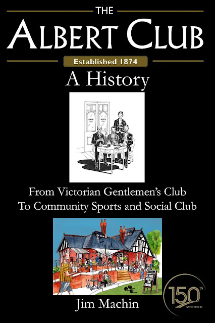
Now I am looking forward to reading The Albert Club, A History, which has been written by Jim Machin.


It is one of those books which combines the story of one sport's club in West Didsbury which was established in 1874 and along the way offers up a wonderful social commentary on both the area and a picture of life over two centuries.

Jim Writes, 

"Pre-order your copy at the Albert Club now, over the bar for £10. All profits will go to the Albert Club. 

The Albert Club started in 1874 as a gentlemen’s club for the wealthy merchants, industrialists, and professionals of late-Victorian Manchester, especially those living in West Didsbury, Didsbury and Withington.

It is now a thriving community sports and social club at the heart of West Didsbury life.

Designed by leading Manchester architects of the time, it is believed that the club is the oldest lawn tennis club, still using the same original clubhouse and grounds, in the world.


How did this happen? Who were the gentlemen? How were they connected? How well-known were they in Manchester and Britain? What was club life like? What were the clubhouse and grounds like? How did the sports develop? How does the club’s story reflect the social history of Manchester and Britain? How long did it take women to be allowed full access? And how did that happen?

There is tragedy and comedy, and evidence of other forgotten Manchester histories. The social norms and dialogue of the earlier eras are often shocking, but sometimes surprisingly similar to the modern day. Some things don’t change!

Written in the style of a reference book, the reader can select those subjects and periods they are interested in, from 1874 right up to the last 35 years.

You can also find out if an early Albert member (1874 to 1924) lived in your house, and what they did for a living.

The book is in Royal format (9" x 6"). The main content of the book is 300 pages long, with another 70 pages of appendices, references, index and introduction".

Here’s what the Albert’s proof readers have been saying:

"Meticulously researched and well written, it brings to life the many generations of Albert members.

It made fascinating reading. You have worked wonders researching the lives of all those amazing early members.

You've done a great job mate! Looking forward to reading the rest.

A fantastic read, absolutely amazing to find out about the history of the club and the courts, you’ve done a fantastic job here and should be really, really proud of yourself!

A love letter to the Albert. Tears in my eyes. Amazing!

A fascinating insight into the people and history of Didsbury.

Undoubtedly the best book about the Albert Club that I have ever seen. I picked it up and could not put it down. Must have been the super glue.

Amazing read. Well done! You must be proud and relieved to have finished.

Hear, hear! Brought tears to my eyes."

The Albert Club, 39-41 Old Lansdowne Road, West Didsbury, Manchester M20 2PA

thealbertclub.co.uk


When the past stubbornly hangs on …..

There will come a time and I am guessing it will not be too long when all those old Chorlton street names will have passed out of living memory.

A little bit of the past, Regents Road, 2024
And that would be a shame.

At present Highfield Road, Regent Road, Church Road, and heaps more cling on remembered by those who knew them.

But that won’t be forever, and then the only record will appear in old directories, some maps, and the former road signs.

And so it is with Regent Road, now Reeves Road, although I doubt this one will last for much longer.

The renaming of many of Chorlton’s roads seems to have occurred in the late 1960s into the 70s and I suppose was about eliminating duplication.

That said it is not new.  Cross Road was variously Cross Street and Cross Lane, while Beech Road was once Chorlton Row, and the start of Whitelow Road was originally Lloyd Street.

Oak Bank, 1959
So never pass an old road sign without recording it for posterity or anyone else.

Location; Reeves Road, 

Picture; When the past stubbornly hangs on, 2024 from the collection of Andrew Simpson, and Oak Bank, 1959, now Silverwood Avenue, A.H.Downes m17489, courtesy of Manchester Libraries, Information and Archives, Manchester City Council, http://images.manchester.gov.uk/index.php?session=pass


Saturday, 27 April 2024

With Reg and David on Chorlton station in 1925 and memories of a book stall in Varese


This is just one of those short little stories which feature some of the people and an unusual scene from the 1920s.

We are on Chorlton railway station beside the W.H.Smith’s bookstall and it is 1925.

On the right is David Ball who was the manager and on the left is Reg Croton who ran a taxi and lived on Sandy Lane.

By the time this picture was taken Reg was 36 and was running the family business.

His father would have made the move from horse drawn cab to motor car and was listed in the 1911 telephone book at Chorlton-c-H 481, CROTON, Chas, Coach Proprietor ...Sandy Lane.

And by another of those links with the past the family home had been a farmhouse and by the 1920s may have been a hundred years old.

But it is also the bookstall that fascinates me.  In their way these kiosks have changed little. To quote another famous retailer the simple approach was to “pile 'em high and sell 'em cheap.”  There is here everything the train traveller might want, need or just be seduced into buying.   So, there are piles of books, pencils, crayons, what look like paint brushes, and piles of books and magazines, including the latest issue of the Strand Magazine with a story by P.G.Woodhouse.

And as ever it is the adverts that draw you into the period.  Amateur Garden at 2d, with articles on "Bedding Plants, Dahlia Culture and Melons and Tomatoes" which underlines the growing leisure time that some of our new residents could enjoy.  But for me it is the WHS Pen in its smart case that intrigues me along with the ad “BOOKS WE’D LIKE TO BURN”

These old fashioned kiosks on stations have pretty much vanished as railway stations become just long empty and soulless platforms where even the waiting room is now a glass sided box.

But they live on in other places.

At the bottom of the road in Varese close by our usual bus stop is just such a kiosk where everything seems available, including English magazines and hard by the station is an even busier one which has the added bonus of a taxi rank next door.

Pictures; from the Lloyd collection and the collection of Andrew Simpson

Snapshots of Well Hall ……….. part 1 …….1873

Now this is Well Hall House in 1873.

And what I like about it is the detail showing the old 18th century house, the gardens to the south and the collection of farm buildings to the north, bounded by what is now Kidbrook Lane and assorted cottages beyond.

What interests me is the small water course which feeds into the moat and back in 1873 required a footbridge to cross it.

I must confess that I had never knew that there was a  watercourse or  given any thought to how the moat would have once been supplied.

Which is a huge omission on my part.

But following the stream east, the map shows it joins the River Quaggy.

And opens up that fascinating bit of speculation as to whether our water course was a feeder for the river, or if it had been dug from the Quaggy to fill the moat.

I rather think I must get in touch with the Environment Agency.

On the other hand, I bet there will be someone who knows and will gently point out the obvious to me.

We shall see.

Location; Well Hall

Picture; Well Hall House and surrounding land, 1873, from the OS map of Kent, 1858-1873, First Edition, six inch to the mile, courtesy of Digital Archives Association, http://digitalarchives.co.uk/


Ghosts ....... a different Camp Street

Now I am fairly confident that this picture of Camp Street will not chime with many people.

Camp Street, 1966
It is still there, running from Deansgate down to Lower Byrom Street, but the properties which stretched along it, and the streets to the south which included Severn Street and Eltoft, have all gone.

The area was redeveloped in the late 1960s and early 1970s and that consigned all of those streets as well as Dumville and Gillow Street pretty much to the memories of those that lived here, and on old maps, and pictures.

I often walk what is left, but that older network of narrow streets and old buildings was unknown to me.

Leaving me just to use the the OS map of 1951 as a guide.

Cam[p Street, 1951
Although I am confident that friends like Alan will soonoffer up their own memories.

Location; Camp Street, 1960, and 1951

Picture; Camp Street, 1960, and 1951  "Courtesy of Manchester Archives+ Town Hall Photographers' Collection", https://www.flickr.com/photos/manchesterarchiveplus/albums/72157684413651581?fbclid=IwAR0t6qAJ0-XOmfUDDqk9DJlgkcNbMlxN38CZUlHeYY4Uc45EsSMmy9C1YCk