Saturday, 30 November 2024

In Eltham with the Reverend John Kenward Shaw Brooke and some revealing records

John Kenward Shaw Brooke from an engraving in the church
am sitting looking at a picture of the Reverend John Kenward Shaw Brooke and have been reflecting on what started as a simple piece of research about the man led me off in all sorts of directions.


John Kenward Shaw Brooke was vicar of St John’s in Eltham from the age of 24 in 1783 till his death in 1840.

Such was his reputation in the parish that on the jubilee of his tenure in office the newly built row of cottages owned by John Fry became known as Jubilee Cottages, a name they retained till their demolition in 1957.

He was in the words of the local historian R.R.C. Gregory “a man greatly revered of strong character, and holding the office of Vicar for the long period of fifty-seven years, he has left a mark upon parochial history more indelible, perhaps, than that of any preceding Vicar.”*

So much so that over 70 years after his death in the summer of 1909 there were engravings of the man “in many of the homes of Eltham ...and so impressive were the demonstrations that took place [to commemorate his fifty years on office in 1833] that the children and grandchildren of those who witnessed them find to this day, a congenial theme for conversational purposes.”

Cover of the by Rev Myers, 1841 
Nor was this all for just a year after his death his life and contribution were recorded in a 22 page booklet focusing particularly on his establishment of the National Infant and Sunday Schools, the endowment he left to the school and his other charity work.**

And as I dug deeper I got side tracked and despite serious efforts to return to our man I was led off on different tracks.

All of which began with the poll books which are not only a record of who could vote in Parliamentary elections but also how they voted.

John Kenward Shaw Brooke appears in a number of them from the late 18th century into the 19th and encompassing the great election after the 1832 Reform Act.

The first comes from 1790 and the last in 1838, and what they show is that the Reverend Shaw Brooke consistently voted Tory.

One of thast enteries by the Reverend Shaw Brook in December 1839
Nor is this all for like so many men of the period he voted in more than one place.

So along with Eltham he was registered in the parish of St Dunstan in the West in the City of London and Wickhambreaux which is just five miles from Canterbury.

And like so many clergymen of the period he also managed more than one church.

In his case the second living was at the Rectory of Hurst-Pierpoint, in Sussex, “where respect and esteem ever awaited him; and where, although his residence was limited to a few weeks annually, he lost no opportunity of promoting the well being of his parishioners, by his sanction and liberal support of every means of advancing their temporal and spiritual interests.”***

But it was in Eltham where he was most busy and trawling the parish records there frequently is his name and of course his handwriting which for any historian is an exciting link with both the man and the period.


Here too purely by chance I came across the burial record of Lucy Jeffery who died in her first year in the June of 1841.

Only weeks before I had uncovered her baptismal records along with her siblings and in the course of charting the family through from the 1840s noted she had fallen off the official records.  At the time I assumed she had changed her name on marriage, and thought that I would follow it up in the future.

Not so, she was buried on June 19th in the parish church yard, which led me to ponder on the ages of the others laid to rest during the period. In time I think it will turn into a major piece of research but for now of the 48 buried during 1840, 19 were under the age of 5 of which many were never to see their first birthday.

Burial record for John Kenward Shaw Brook
It is unscientific, lacks at present any details of the causes of death and is confined to that one year but most of us will I suspect reflect on the lost lives and unfilled futures which they represent.

John Kenward Shaw Brooke had died the year before aged 81 and was buried on December 23rd 1840.

Pictures; John Kenward Shaw Brookes from The story of Royal Eltham, R.R.C. Gregory, 1909 and published on The story of Royal Eltham, by Roy Ayers, http://www.gregory.elthamhistory.org.uk/bookpages/i001.htm,

*The story of Royal Eltham, R.R.C. Gregory, 1909

**Rev W.T.Myers, 1841

***ibid R.R.C. Gregory

Remembering the eight children of Charles, Elizabeth, and Hannah Sharp ....... Ashton under Lyne in the 19th century

It will have been sometime in the summer of 1979 that I came across this grave stone in the parish church in Ashton-Under-Lyne.

The gravestone, the parish church yard, 1979
I had wandered past it for years and never really noticed it, but on that day by chance I stopped and looked at the memorial to the eight children of Charles, Elizabeth and Hannah Sharp who all died between 1839 and 1843.

Of the eight, only one reached the age of 18 with other seven dying between the ages of 2 months and one year and a bit.

It is a powerful reminder of the level of infant mortality in the not so distant past and is one that I have used over the years to illustrate just how uncertain were the chances of surviving to the age of 5.

And while I had transcribed it and included it in stories and articles, I have never reproduced the original memorial stone or gone looking for the family.

But today I have done just that and it has been a slow process taking up a big part of a morning and even now I have not got very far.

I know that Mr Sharp was married three times, and that his wives were Elizabeth, Hannah, and Sarah.

His marriage to Hannah took place in what is now Manchester Cathedral in June 1834 and he married Sarah in 1851 in Ashton-Under-Lyne.

This third marriage was sometime between January and March, and in April they are recorded as living at 10 Old Cross which was close to the parish church.  He described his occupation as “Hair  dresser and seedsman”, which chimes in with an earlier reference in 1828 to him in a directory as living on Old Street and earning a living as a “seedsman”.

In 1861 they had moved to the small village of Hotham where he continued to describe himself as a “seedsman” but also as a “Lodge Gate Keeper”.*

The children
Of his children I have so far only come across a reference to the baptism and death of Charles Slater Sharp, which occurred in 1843 but in time the others may come out of the shadows.

As it is, the death of Thomas aged 18 in 1839 might offer a clue as to his father’s marriage to Elizabeth which must be sometime at the start of the 1820s if not earlier.

I doubt we will ever know why Charles and Sarah moved to Yorkshire.

Places the Sharp's would have known, Ashton-Under-Lyne, 1854
It may be that they were returning to his birth county or perhaps the tiny rural village offered job opportunities and a quality of life which was no longer the case in Ashton.  Mr Piggot’s Directory for 1828 had commented that “its new streets are well built and contain many good and some elegant residences; but the old streets are narrow” and while in 1826, “the number of steam engines in Ashton was thirty-four, ..... at this period [1828] the number and power has greatly increased”, which was to continue into the 1860s.

By comparison, Hotham in 1825 contained just 62 houses and 203 inhabitants, which by 2011 had only grown to 233.**

Of course there is that darker and sadder explanation which falls back on the need to move away from such a litany of tragedy.

Location Ashton-Under-Lyne

Picture; the gravestone of the Sharp family, 1979, parish church, Ashton-Under-Lyne, from the collection of Andrew Simpson, and Old Ssquare, close to where the Sharp's lived, from the OS, Lancashire, 1854, courtesy of Digital Archives Association, http://digitalarchives.co.uk/

*Pigots Directory, 1828, Census Enu 1s 2 Ashton-Under-Lyne, Hotham Yorkshire, 1861, page 214

**A Topographical Dictionary of the United Kingdom, Benjamin Pitts Capper, 1825, page 432
Down at the Savoy Cinema in 1937 on Manchester Road watching Road to Glory

Now back in the summer of 1937 I could have had three cinemas to choose from here in Chorlton and of these the most impressive was the Savoy on Manchester Road which had opened in 1920 as the Picture House before being renamed the Savoy when it was leased to the Savoy Cinemas and later became the Gaumont.

And in the summer of 1937 for three days I could have gone and seen Road to Glory made the year before by Howard Hawks which told the story of trench life during the Great War through the lives of a French regiment and included as you would expect a tangled “love interest” between a nurse and two officers.

I am not sure it would have appealed but at least I know what was on offer and that is thanks to Peter McLoughlin who shared this film bill with me.

I doubt that there are many of these still knocking around.  After all they are the sort of thing which you pick and then discard but this one has survived it is a wonderful insight into a night at the “flicks.”

The obvious starting point are the films themselves and in time I will look them all up and in the process get something of an idea of what the cinema going public were being offered back then.

For modern audiences the frequency of the shows will also be a revelation.  

When I was growing up in the 1950s you got I think a week of the same show, but two decades earlier and programmes changed more regularly which I guess is both a recognition of the number of films being churned out but also that people went to the pictures more than once a week.

Not that this should be much of a surprise.  In an age before the telly the pictures offered a nights entertainment which included the film and a newsreel and was all done with style.

The old flea pits still existed but the big purpose built cinemas of the 1920s and more especially the 30’s gave you a sense of luxury which started with the uniformed doorman and continued with that plush auditorium which was light and bright and had a distinctive smell which I guess was a mix of those thick carpets and the floor polish and much later there was the smell of the hot dogs slowly cooking in a corner beyond the box office.

And the picture houses were warm which on a cold winter’s night was another attraction and on one of those dark nights they would be one of the only buildings which were lit up and acted a beacon as well as a promise of a good night ahead.

All of which brings me back to that film bill and the simple observation that you should always be careful about what you are going to throw away.

Pictures; film bill for the Savoy ABC, 1937 courtesy of Peter McLoughlin, and the Picture House later the Savoy, 1922, from the Lloyd Collection.


Friday, 29 November 2024

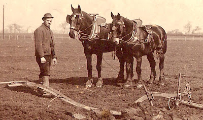
Ours was a time still dominated by working animals


Ours was a time still dominated by working animals.

For centuries the main draught animal had been the oxen and in some parts of the country their use continued well on till the end of the 19th century and the start of the twentieth.

But by the 1840s the horse had taken over in most areas.

The horse was a familiar sight here in the township.  As well as working the fields, they would have pulled the carts and wagons of the farmers and carriers as well as the coaches of the well to do.

Horses provided work for the blacksmith, and the farrier and indirectly for the wheelwright.  Then there were the men who worked with the horses.  Of these the ploughman and the carter earned more than most other farm workers.  The carter after all was assured a regular wage because horses needed to be looked after all the year round, unlike the farm labourer who could expect seasonal periods of unemployment.

But most farm workers came into some contact with horses at some point and on the smaller farms and market gardens, the job of caring and working with horses fell to the farmer or his son.

The Bailey family on the Row who farmed seven acres had just one horse which would have doubled for both ploughing and pulling the spring cart.  

This would have been the pattern here with so many of our market gardens operating with less than 10 acres of land.

On our bigger farms there were men who were employed specifically to deal with the horses.  James Higginbotham, farmer on the green employed a carter and at Dog House Farm just outside the township eight of the men who lived on this 380 acre farm were carters.

Here horses were worked in pairs and there might be two or three teams each with a carter and mate.  The most intensive period for a working horse were sowing wheat, or turnips, carting mangels and harvest time.

Many carters formed close bonds with their horses, a bond which was deepened by the long hours they spent together.  

A carter might start as early as five in the morning as the horses were prepared for work and last after the day had finished in the fields.

The horses had to be cleaned of the thick mud they had picked up and then fed, watered and groomed.

For this a carter might be paid just over £1 a week, although James Higginbotham was less generous.  During the mid 1840s he was paying his carters between 4s 6d [22p] and 6s [30p] a week.  But these wages reflected the fact that the men lived in and so received their food and lodging as part of their wages.

This supplement could make a difference of between 5s [25p] and 7s [35p] a week.   Even given this their wages seem much lower.

From THE STORY OF CHORLTON-CUM-HARDY, Andrew Simpson, http://chorltonhistory.blogspot.co.uk/2012/10/the-story-of-chorlton-cum-hardy-new.html

Pictures; from the collections of Allan Brown, Carolyn Willitts  and the Lloyd collection

Walking Well Hall Lane in 1843, all fields and not a lot else

I am back in Well Hall, or to be more accurate just north of what was Well Hall House and heading north through what is now the Progress Estate.

What is now Well Hall Pleasaunce is down at the bottom of the map, and our journey up along Well Hall Lane to Shooters Hill would have been a pleasant enough stroll past open fields.

Now what makes this such a fascinating stroll is that courtesy of this tithe map and the accompanying notes, we know who owned this land, who rented it and what it was used for.

All of which makes such a stroll a journey deep into the Eltham of the 1840s.  We can even find out who lived in the cottages in that year and comparing these with census returns, and rate books get an idea of just how long people stayed put in one place.

Location; Well Hall, Eltham, London


Picture; detail of the land to the north of 1843 from the Tithe map for Eltham courtesy of Kent History and Library Centre, Maidstone, 
http://www.kent.gov.uk/leisure_and_culture/kent_history/kent_history__library_centre.aspx


A bus for every occasion .......

The Museum of Transport on Queens Road really does have a bus for every occasion as well as offering examples from all over Greater Manchester, along with "coaches, trams, objects and displays".


Here can be found the Corpi red of Manchester, the green livery of Salford, as well as blue buses, mauve, and of course that odd coloured offering from what was SENEC.

Nor is that all, because  there is a fire engine, a horse drawn vehicle and the opportunity to sit inside a number of those old rear entry buses which those of us of a certain generation remember with affection.

And while those old style buses allowed you to hop on and off and even to chase after them with a view to jumping aboard, they were not user friendly to the disabled and out of reach to anyone using a wheel chair.

Upstairs volunteers are working on the records of the old companies transferring the lists of employees from hard paper to digital which in time will be available to those wanting to study the history of Greater Manchester.

I had never been before and it was a revelation made all the more memorable by the premises which dates back to 1930s and was originally part of the bus garage, which was later used by the G.P.O to service their vans and lorries, before becoming a museum.


It is open on Wednesdays and weekends and attracts a wide range of visitors, from school parties to crinklies like me.


Location; The Museum of Transport on Queens Road


Pictures; wot I saw on my trip to the museum, 2024, from  collection of Andrew Simpson

*Museum of Transport Greater Manchester,  https://motgm.uk/ 


Back on the streets of Ashton-Under-Lyne in the 19th century

Victorian Ashton, 1974

I have fond memories of Ashton-Under-Lyne.

It was where I lived for three years in a small terraced house off Penny Meadow and it suited me just fine.

It was after all about as far away from south Manchester as you could go and the life of a student which had been my lot for four years.

But above all for someone interested in 19th century history it had the lot.  Here were the mills, a canal and a fine market hall and the old PSA building.*

Now I know that if I had washed up in Oldham, Rochdale or any one of a number of the mills towns in the region I would have found something of the same, but Ashton was where we lived and it was Ashton’s industrial and social past that we explored in the mid 1970s.

It was a place which really came into its own during the 19th century.  So while it had been a market town since 1284 it remained a small place until the Industrial Revolution.

Its population in 1775 was about five thousand and according to one account the town was contained in “four narrow dark streets formed by mean looking dwellings.”**

But during the last quarter of the 18th century and the first four decades of the 19th it rapidly expanded as the textile industries were developed.

So the population increased and in just fifteen years from 1827 “the place has been rapidly augmented; .... the banks of the canal and the Tame are now lined by numerous streets; the area betwixt Old Street and Charlestown is nearly built upon, and a portion of it forms  a spacious Market-place, on the north side of which is erected an elegant Town Hall; the fields formerly bordering on the north of the Old Cross have been transformed into street avenues; the east side of the Rectory has received a large accession of habitations, the west side of Oldham Road is become a portion of the town; and the vicinities of Henry-square and St Peter’s Church abound with edifices.”***

Ashton, 1841-54
It is a story which has been told in part but for me one of the most excellent and enduring accounts is that of Victorian Ashton which as the Preface says, is not so much a history of Ashton in the 19th century but “a collection of essays dealing with aspects of life at the time, and a record of what remains of the period today.”****

I bought it back in 1974 when it was first published and regularly go back to it. It includes articles on 19th century housing, the Churches and Chapels, leisure and Industrial Archaeology along with descriptions of Chartist activity and individuals like Hugh Mason.

Ashton in 1834
In the almost forty years since the publication of Victorian Ashton, the town has changed a lot and some of the places featured in the book will have gone.

Rereading the section on the Industrial Archaeology of Ashton-under-Lyne by Owen Ashmore is to be reminded of just how much of the economic and industrial landscape has altered in the last four decades.

Likewise the account of the town’s 19th century housing by Sylvia A. Harrop is a wonderful record of what was and still is.

Ashton in 1821
So I am rather pleased that I still have my forty year old copy of Victorian Ashton, and equally pleased that it is still available from Tameside Local Studies and Archives Centre.*****

What is all the more remarkable is that while I paid 75p for it in 1974, it still retails for just a £1, which I reckon has got to be a major incentive to get a copy.

Pictures; Victorian Ashton, courtesy of Tameside Local Studies and Archives Centre, population increase taken from Nineteenth Century Housing in Ashton, Sylvia Harrop, Victorian Ashton, and detail of the town centre from the OS map for Lancashire, 1841-54, courtesy of Digital Archives, http://www.digitalarchives.co.uk/ extracts of Ashton in the 1830s from Butterworth Edwin, A Historical Account of the towns of Ashton-Under-Lyne, Stalybridge and Duckinfield,


*Pleasant Sunday Afternoon Brotherhood, http://chorltonhistory.blogspot.co.uk/2012/06/tram-and-pleasant-sunday-afternoon.html
**Butterworth Edwin, A Historical Account of the towns of Ashton-Under-Lyne, Stalybridge and Duckinfield, 1842, page 52
***ibid Butterworth, page 54
**** Victorian Ashton, Ed by Sylvia A. Harrop and E.A. Rose, Tameside Libraries and Arts Committee 1974
*****Tameside Local Studies and Archives Centre, Central Library, Old Street, Ashton-under-Lyne, OL6 7SG, http://www.tameside.gov.uk/archives

The Chorlton Carnival "the most considerable effort of its kind undertaken in the city"


Now there is a story to tell about the Chorlton Carnival which ran through the 1930s and echoed the village celebrations of a century before.


Walking through Chorlton, date unknown
These earlier ones I have researched and written about in my book but those from the 1930s are still as yet only a vague promise of things to come.

This is all the more important given that they will soon pass out of living memory and I doubt that there are many accounts of what went on.

It was it seems linked to the Alexandra Rose Day which was the prime fund raising activity for medical charities in the Manchester and Salford area and dated back to the first held in London in 1912.

There were a number of carnivals across the city during the 1930s but ours seemed to be the biggest, according the Manchester Guardian in the June of 1937, “The gala held in St Margaret’s playing fields, Chorlton-cum-Hardy, on Saturday [June 19th] may be said to mark the opening of the charity carnival season. 

 
The parade
It has a history of five or six years, but already it has become perhaps the most considerable effort of its kind undertaken in the city on behalf of the Manchester and Salford Charities’ Fund.”*


The format was much the same with the crowning of a Rose Queen a procession through Chorlton “of characters in comic and fancy dress, on horseback, cycle or on foot.” and the gala which included Morris dancing, a horse show and a brass band competition. The 1937 show had excelled itself with five bands taking part but so far there is no record of whether our own band won a prize.

I must confess a little pride in knowing that the procession set off from the Rec after the crowning of the Queen and have often speculated whether Joe and Mary Ann Scott who lived opposite in the house we now occupy were in the crowd.

Oswald Road
A generation earlier and most of the horses competing for prizes at the show at St Margret’s playing fields would have been from the local farms but by the time the carnival was staged the contest was between the tradesmen. Men like Enoch Royle and Bill Mellor who were coal merchant or the many shop keepers who still delivered in the years before the last world war.

And it may have been the war that contributed to it coming to an end. The last seems to have been in 1938 and the break of ten years and changing attitudes made it less likely that it would come back.

In 1948 the Labour Government had introduced a national health service which made the penny finding activities of hospitals and medical charities less necessary.

And for those with a keen sens of the past here is Andy Robertson's picture of the same spot taken a few years ago.

Oswald Road, 2016
He says, "re picture in today's blog. I think this must be on the corner of Ransfield (Richmond Road). 

It is not the ones on the corner of Claridge or Kensington and I know of no others. 

Also if you check out that old Lloyd photo you posted of Oswald Road a while back there is that big Tree!"

Location; Chorlton-cum-Hardy

Picture; Horses being paraded along Oswald Road sometime in the 1930s, courtesy of Mrs Kay, from the Lloyd collection and the shop on Oswald Road, courtesy of Andy Robertson

*Manchester Guardian June 21 1937

Thursday, 28 November 2024

With John Fry, builder, sawyer, land agent and appraiser in Eltham circa 1837

Fry's Buildings numbered as 264-275 in 1844
John Fry is another of those people that has faded pretty much from history.

He appears only once in The Story of Royal Eltham* and yet the more I looked into the contemporary records the more there was about the man.

He is there of course in the census returns but also the land tax records, the tithe schedule and the parish records.

Not bad for a man who up until recently I knew only as a name for a block of cottages tucked behind the High Street.

All of which remains an instructive lesson in how even the forgotten of history can be rediscovered.

Which begs the question of why John Fry?

The answer is partly because the paper trail is there and also that such people were important to the community and so deserve to be recorded as such.

He was born in 1792 in Kent, possibly at Tunbridge and may have been in Eltham by 1818 for although I can find no record of his marriage to Henrietta she was from Eltham and their first daughter was baptized in the parish church in October 1819.

The Smithy just a littel east of their home, 1909
He described himself variously as a builder, carpenter, sawyer, land agent and appraiser and in 1833 he built Fry’s Buildings which were just north of the High Street.

They were twelve wooden cottages** which faced east across the fields with longish gardens at the rear.

The buildings were only demolished in 1957 to make way for an extension to Hinds Store and an additional playground to the old village school on Roper Street.

As cottages go they were a decent size consisting of three rooms upstairs and two down.***  And in 1837 were assessed for the land tax at £3 12shillings.

It was these properties which allowed him to qualify to vote in Parliamentary elections and in the election of 1837 he voted for the two Tory candidates.

Fry's Buidlings and their home shown in in yellow, 1858-73
His standing in the community was high enough for him to be one of the assessors for the land tax in 1837 and he was active as a church warden.

All of which does bring him out of the shadows.

We know also that his three daughters were all baptized in the parish church, and that he his eldest was still living with him in 1871.****

There is still much to uncover but as  a start I am pretty pleased with how much we know about John and Harriet and so we will leave them in their house set back from the High Street in a long garden a little west of his twelve cottages.

This house, the workshop and his garden he rented from a Francis Kirkpatrick of which
more later.

Location; Eltham, London

*R.R.C.Gregory, the Story of Royal Eltham, 1909
**Ibid Gregory
***1911 census
**** Harriet, 1819, Lydia, 1823,and Sarah 1825

Pictures, detail of Eltham High Street,  1844 from the Tithe map for Eltham courtesy of Kent History and Library Centre, Maidstone, http://www.kent.gov.uk/leisure_and_culture/kent_history/kent_history__library_centre.aspx
and Fry's Buildings from the the OS map of Kent 1858-73, the Smithy from The story of Royal Eltham, R.R.C. Gregory, 1909 and published on The story of Royal Eltham, by Roy Ayers, http://www.gregory.elthamhistory.org.uk/bookpages/i001.htm

“I make no rash promises …. promises never fulfilled and perhaps never meant to be” ……

Yesterday I wrote about the election campaign of Frank Beverley who stood as the candidate for the Chorlton-cum-Hardy Labour Party in the local elections of 1937.

At the time I had yet to uncover his election address containing the outline of what he stood for.

Happily today I have that address in front of me and it makes interesting reading, partly because of its honesty but also because the points he made 85 years ago have a resonance with the problems faced by many during this “Crisis in the cost of living” and the response of some in National Government.

So here it is, along with the endorsement by the Chorlton-cum-Hardy Labour Party.

He lost, and the story of that election can be read by following the link.

Location; Chorlton-cum-Hardy

Pictures; Election leaflet, courtesy of Cllr Mathew Benham 


*Mr. Frank Beverley ……. Chorlton-cum-Hardy .... 1937, https://chorltonhistory.blogspot.com/2023/01/mr-frank-beverley-chorlton-cum-hardy.html

As others saw us, travelling across the North West in 1792, part 1 Ashton Under-Lyne

Now something new was happening in the North at the end of the 18th century and it was attracting the interest of the rest of the country as well as from further afield.

Just 40 years after our tourist visited Ashton
These visitors marvelled at the new technology, shuddered at the awful conditions and to use that much used phrase confidently proclaimed they had seen the future and it worked.

Their observations have been collected, repackaged and represented in numerous books about the period but there are still plenty who have lain forgotten.

So here is the first of a series representing the experiences of the less familiar starting with an unknown tourist from Worcestershire who made his way across the North West in 1792.

And by 1853 this was the centre of Ashton
On the way he encountered bad food, dangerous roads, dubious resting places but also the wonders of that new technology.

“Friday morning went to Ashton-under-Lyne to see Mills & Machine for Carding & Spinning of Cotton; which is very curious & Surprising to see The Spinning Mules & Jennys, as they call ‘em, Spin 144 threads at once, & will spin one Pound of Cotton to so fine a thread that it will reach – according to Calculation -168,000 Yards or 95 miles &½.

Then its weav’d into Aprons, Handkerchiefs, & c.

Likewise saw the Iron works where they Cast Iron Rolls & Cylinders & Bore thro ; an Iron Pipe, the same as we Bore a Pump.

It goes by Water, & the Wheels as Large as our Mill wheels-all Cast Iron Except the Water wheel.  They likewise turn Large Iron work in a Lathe, the same as our Carpenters turn a Piece of Wood.

Very wet this Afternoon.”

Picture; Ashton-Under-Lyne, from the Map of the inland navigation canals and rail roads with the situations of the various mineral productions throughout Great Britain from actual surveys projected on the basis of the trigonometrical survey made by the order of the honourable the Board of Ordnance, John Walker, Richard Nicholson and Joseph Priestley, 1830, and detail of the town centre from the OS map for Lancashire, 1841-53,  courtesy of Digital Archives. Association,    http://www.digitalarchives.co.uk/

*A Tourist’s Diary, Countryman sees the Sights, Mills Quays, and Prisons, from ‘A Journey to Manchester and Liverpool from Broadway’ 1792, published in the Manchester Guardian, July 16. 1936

Nothing more evocative than a bus stop

How easy it is to forget or never knew an older way to travel by bus through Salford.


And just for good measure because I can and because once I chanced my pocket money on a machine like this, here is how sweets were dispensed long before now


Leaving me just to complete the trio of lost Salford transport, with the bus to the "Docks" which is now as much a lost item as an old penny, the Bandit biscuit and jumping on a slow moving bus from the rear.


Location; Transport Museum, Queen Street, Manchester

Picture; Salford Bus Stop, vending machine, and the 71 Bus, undated, from the collection of Andrew Simpson, 2024 

Wednesday, 27 November 2024

Never let prejudice get in the way of history ….. walking New Islington

Now, I have a habit of getting sniffy about the new names developers and city planners give to old bits of Manchester.

The Ashton Canal, 2022
So, over the years I have been a bit dismissive of the names like The Northern Quarter, Spinnyfields, and New Islington.

Only to find that there is often a basis for these names.

And so, it is with New Islington which is that area roughly between the Rochdale and Ashton Canals.

In my ignorance I assumed the name had been dreamed up by some smart backroom young thing as an echo of that other place in London.

But not so apparently back in 2000, the residents of what was then called the Cardroom Estate were asked to choose a new name for the area in advance of regeneration plans and with the help of Urban Splash “choose the area’s new name (taking their inspiration from the name of a road that ran through the estate)”.*

New Islington, 1851
This was New Islington Road, which was cut sometime between 1844 and 1853, and in turn references the name New Islington which appears on maps dating back into the 18th century.

So once again the lesson is never get sniffy before looking back into the past.

And the history of the area pretty much confirms that simple observation that canals make for development.

In the late 18th century Green’s map of 1794 shows the area as open land but indicates the line of the “Intended Ashton Canal" while Johnson’s map of 1819 shows a only limited development.

Relics, 2022
That said between the OS map of 1844 and Adshead’s map of just seven years later New Islington has followed the patten of other parts of the city and is characterised by acres of densely packed terrace houses, textile mills, dye works, plenty of coal yards and a foundry.

All very different from the smart properties which today line the canal along with the equally smart bars, restaurants, and heaps more including a free school and the aptly named Cotton Field which is “an idyllic water park where you can escape the hustle and bustle of the city. 

Improvement works have recently been completed, and it’s used daily by families and people young and old for fitness and sport, walking and picnics*.**

The multi coloured set of homes, 2022
I am glad I took Timmy tram yesterday and visited the area, motivated by curiosity and the sunshine.

The challenge now is to go back and wander the New Islington of 1851 and in particular to get a sense of who lived there and where they may have worked.

And while that is in progress I think a few more visits back to the area, perhaps looking at how many of the old streets have survived along with buildings from the mis 19th century, and matching those discoveries with the continued rose of the new tower blocks.

Rising blocks, 2022

Location; New Islington

Pictures; walking New Islington, 2022, from the collection of Andrew Simpson, and in 1851 from Adshead’s map of Manchester, Digital Archives Association, http://www.digitalarchives.co.uk/ 


*The regeneration of New Islington - Creating Manchester's most thriving neighbourhood, urbansplash, https://www.urbansplash.co.uk/blog/the-regeneration-of-new-islington

**This is the place: why New Islington is now the best place to live in Manchester city centre, I Love Manchester, Chris Greenhalgh, January 10th 2020, https://ilovemanchester.com/new-islington-best-place-to-live-manchester-city-centre

Going to school in Eltham in 1840

Now the National School  was opened in 1814 by the Reverend J.K. Shaw Brooke.

These were church schools and provided elementary education for the children of the poor.

They were the product of the National Society which had begun in 1811 and aimed to establish a national school in every parish delivering a curriculum based on the teaching of the church.

According to a report of the Charity Commissioners from 1819 the annual salary of the school master was to be £20 and by one of those wonderful chance survivals the first register was preserved which the historian R.R.C.Gregory published in his of Eltham.*

“Amongst the “batch of boys admitted were many bearing names that are still familiar in Eltham,
James Shearing, aged 7
John Scriven, aged 11
Thomas Foster, aged 6
Edward Hand, aged 10, 
William Stevens, aged 6
Charles Russell, aged 9
James Kingston, aged 7
I. Wakeman, aged 6
T.Wakeman, aged 8.”

And just like these names were familiar to Mr Gregory and his readers in 1909, some have stepped out of the shadows again today.

Thomas Foster was the son of the blacksmith who helped run the smithy on the High Street and the Wakeman boys were I think related to Peter Wakeman who had been invited to the Jubilee celebrations to mark the Reverend J.K. Shaw Brooke’s fifty years as vicar of Eltham.

This first school was at the end of Pound Place where it joined Back Lane and 1840 the infants’ school was added.

Now given that I have already mentioned Richard White who taught at the school in 1841, and lived on Pound Place I reckon there are a few more stories to come on the National School, its teachers and students.

Location; Eltham, London


Pictures; The National Infants School 1909,  from The story of Royal Eltham, R.R.C. Gregory, 1909 and published on The story of Royal Eltham, by Roy Ayers, http://www.gregory.elthamhistory.org.uk/bookpages/i001.htm

Chorlton's brass band


There is something about old photographs and as much as I like the ones of the buildings, fields and roads of Chorlton it is those that contain people that I am drawn to.

This is our own brass band sometime in the 1920s and at least a few like William Mellor on the extreme right played in the 1893 band which I featured back in November of last year.*


Ours was one of the oldest brass bands in the country having been started in the 1820s.

 Of course the Stalybridge Band is older and can claim to have marched in to St Peter’s Fields on the day of Peterloo but ours had an almost continuous run until it agreed to wind up after the last world war.

 It performed in many of the great and not so great events here in the township and went on to win prizes in brass band competitions.

What makes this one that little more interesting is that none of them are in uniform. Perhaps it was an impromptu photograph with at least one chap still in what I think is the uniform of a Manchester Corporation tram driver. But I wait to be corrected. Nor can it be the full band.

But I am going to leave the band for another time and focus instead on the three young faces behind the bandsman.

In those early years of photography stretching into the 1920s when it was all still a novelty the camera attracted the curious and the vain. They appear on the edges of a picture always staring directly into the lens but never really part of what is going on.

I would love to know more about three children especially the girl in the middle. Were they related to the bandsman? Had they followed the camera man or was it just chance that they were staring over the wall when the bandsman pose?

I doubt that we will ever know who they were, or for that matter where it was taken. My guess is in the schoolyard of the old National School which could place our three interlopers in Number 1 Passage which runs behind the old playground wall from what was once called Crescent Road and is now Crossland. But there are some things I suppose we will never know.

Picture; from the collection of Allan Brown, some of the band circa 1920s and William Rogers in 1893


*http://chorltonhistory.blogspot.co.uk/2011/11/1893-brass-band-lives-revealed.html